Residents from communities near Ecuador’s Tungurahua volcano faced a massive cleaning operation on Thursday (19 November) after the volcano erupted, covering houses and fields with smoke and ash. Authorities issued an orange alert as emissions reached 2,500 metres above the crater.
In nearby Queros, one of the most affected communities, officials registered 10kg of ash per square metre.
As he swept the street near his house, resident Luis Vaca said the volcanic material was damaging crops. “Ash is falling everywhere; it’s strong, especially in the countryside where it’s falling more heavily. It’s damaging the crops. It would be good if the president came to visit us,” he said.
Tungurahua spews hot lava and ash at night (1999), As of July 2015 Tungurahua Volcano is still active and is under constant monitoring by EPN Geophysics Institute, National Polytechnic School. Wikipedia.org
Tungurahua at night as of July 2015 a constant monitoring by E.P.N. Geophysics Institute..Wikipedia.org
QUITO, Ecuador (AP) ” A second volcano is once again spewing plumes of ash in the mountain chain near Ecuador’s capital.
The country’s Geophysics Institute says the Tungurahua volcano shot out several bursts of gas and ash over the weekend, with one reaching more than a mile (about 2 kilometers) above 16,475-foot (5,023-meter) summit. It also hurled incandescent rock onto its slope.
The volcano observatory reports a change in activity, which could herald a new eruptive phase in the near future. Starting from yesterday at approximately 17:00 (local time), increased steaming and gas emissions were visible, producing a column reaching about 1 km height. Incandescence in the crater area could be detected at night as well. Previously, activity had been consisting of weak steaming producing a column of less than 200 m height. Seismically, there has been a slight increase in the number of events related to rock fracturing and fluid movements within the volcano, but seismic activity still remains at a level considered moderate to low.
…
…
Satellite image of Tungurahua volcano by (c) Google Earth View
Ecuadorian Tungurahua volcano today reported a slight increase in the energy of seismic activity, after the blast past Sunday, the Geophysical Institute of the National Polytechnic School (IG) reported. The IG said that from about 04:10 local time on Tuesday, there is a tremor signal emission, which from 06:50 local time saturates the stations near the volcano of 5016 meters. Since the last time the intensity and length of the howlings have increased, said the IG, and explained that due to the presence of high clouds in the volcano area there have been no observations of the surface manifestations. The National Secretariat for Risk Management (SNGR) on Sunday decreed alert, of caution at the volcano area, with a possible increase in the activity of the colossus after the explosion of great intensity that day and the ejection of a high column of ash and rocks. The Tungurahua, located about 45 miles south of Quito, its current eruptive process began in 1999 and has since periods of intense activity interspersed with periods of relative calm. The population of areas near the volcano were affected on Sunday by falling rubble of black and pink color, while other remote areas received falling of thick black ash. Authorities Risk Management Secretariat volcano kept under constant observation to implement the measures in case of an increase in its activity.
Scientists say lava flow and ash and gas emissions have intensified at a second Ecuadorean volcano, Reventador, as the full-bore eruption of the Tungurahua cone continues. Ecuador’s Geophysics Institute says the lava flow on Reventador’s southern flank has increased since Saturday but poses no immediate threat to villagers in the region 60 miles (100) kilometers) east of the capital, Quito. The 11,400-foot (3,475-meter) volcano is nearly three times that distance from Tungurahua to the southwest. It has been roaring since Sunday, when 200 people were evacuated from its flanks and one pyroclastic blast was heard as far away as the coastal city of Guayaquil. Tungurahua is 16,480 feet (5,023 meters) high and has been active since 1999. Reventador had its last big eruption in November 2002.
IGPEN reports an increase of seismic activity over the past days which might herald a new phase of activity in the near future. The number of earthquakes associated with fluid movement within the volcano has risen from 10 daily earthquakes on June 20 to 54 earthquakes on 29 June. These so-called long period (LP) earthquakes often reflect an increase in pressure inside the volcano. So far, the earthquakes are small and not felt by people. In the afternoon of 29 June, mild fumarolic activity was observed in the crater area. Gas sensors installed near the volcano showed no increase in the concentration of SO2 gas, which suggests that the conduit is currently blocked by a plug, which supports the idea of increasing pressure inside the volcano. Based on the above, IGPEN warns that the pressure build-up could lead to an explosion that destroys the plug, as has happened on other occasions, such as on 16 December last year, and result in new activity of the volcano such as in March and May this year.
Ecuador’s ever-active Tungurahua had a significant explosive eruption this morning (July 14), producing an impressive ash plume that could be spotted in Quito (135 km away) and pyroclastic flows. The report from the Washington VAAC has ash as high as FL450 (~13 km / 45,000 feet). The eruption was also caught on weather satellite images of the area (see above), spreading to the northeast of the volcano. The pyroclastic flow threat has prompted the Ecuadoran government to evacuate people living nearest to the volcano as well. The explosion was confused with gunfire in towns as distant ~50 km from the volcano and ash from the eruption was falling on towns around Tungurahua as well and a sharp increase in volcanic material in streams and rivers leading from the volcano has also been noticed — mainly ash and gravel, likely tephra (volcanic debris from an explosive eruption). You can see the explosion occur on this two loops of NOAA/NESDIS satellite imagery, one showing the IR loop (animated GIF), with the heat from the ash clearly visible as the explosion happens (top below) and the visible ash cloud (animated GIF – or see still image below) spreading mainly to the north but dispersing quickly after then initial explosion . Both of these loops suggest that the explosion was somewhat of an ephemeral event likely related to the destruction of a lava dome or plug.
Authorities in Ecuador say at least 200 people have been evacuated from near the Tungurahua volcano after it spewed an ash plume more than 5 kilometres (3.1 miles) into the air. The regional director of the National Risk Management Secretariat, Lourdes Mayorga, says the explosion produced ash and pyroclastic flows, and could be felt hundreds of kilometres away. She said Sunday that at least 200 people were evacuated from the zones of Cusua, Chacauco and Juive near the volcano. Authorities declared an orange alert, which allows officials to acquire the goods and carry out works to provide humanitarian assistance if needed. Tungurahua has been active for more than 13 years. The 16,480-foot (5,023-meter) volcano is located about 84 miles (135 kilometres) southeast of the capital, Quito.
The authorities of Ecuador began evacuating people from villages located near the country’s Tungurahua volcano, local media reported on Sunday, July 14. Ecuador’s Tungurahua exploded on Sunday spewing stones, gases and ash from its crater up to over five kilometers (three miles) in the air. No casualties were reported as a result of the explosion. The country’s emergencies ministry reported that some 200 people were evacuated from nearby villages and taken to safer localities, where they were provided with shelter and humanitarian assistance. The volcano, located 135 kilometres (84 miles) southeast of the capital Quito, has been active since 1999. The volcano went through a period of high activity in December last year and in March this year, but no eruption resulted.
Tungurahua volcano in Ecuador spews huge ash plume forcing hundreds from their homes
Authorities in Ecuador say at least 200 people have been evacuated from near the Tungurahua volcano after it spewed an ash plume more than 5 kilometres (3.1 miles) into the air.
A man walks on rocks and ashes spewed by the Tungurahua volcano in the outskirts of Cusua, Tungurahua province, EcuadorPhoto: AP
AP
12:45AM BST 15 Jul 2013
The regional director of the National Risk Management Secretariat, Lourdes Mayorga, says the explosion produced ash and pyroclastic flows, and could be felt hundreds of kilometres away.
Ecuador’s Tungurahua volcano hurled lorry-sized pyroclastic boulders more than a mile in a powerful eruption that prompted at least 300 people to flee their homes, authorities said.
Schools were closed for a third straight day as ash showered down on a dozen towns in the sparsely populated area surrounding the 16,480-foot volcano.
Thundering explosions could be heard miles from Tungurahua, which is on the Andes cordillera 84 miles southeast of Ecuador’s capital, Quito.
Fireball: The Tungurahua Volcano spews ash and stones during an eruption which forced 300 people to flee from their homes
Melting point: A huge ash cloud is formed after the volcano began hurling lorry-sized boulders from its tip
A state Geophysics Institute scientist monitoring the volcano from a nearby observation post said by phone that incandescent boulders were landing up to 1.2 miles beneath crater level.
‘The smallest blocks are that size of an automobile while the biggest reach the size of a truck, which cause impact craters up to 10 meters (33 feet) wide as they hit the flanks,’ the scientist, Silvana Hidalgo, told The Associated Press.
BEN NUCKOLS, Associated Press, STEVE SZKOTAK, Associated Press
FILE – In this Aug. 23, 2011, file photo, a U.S. Park Service helicopter flies between the Washington Monument and the Capitol on the National Mall in Washington, following an earthquake in the Washington area. The unexpected jolt cracked the Washington Monument in spots and toppled delicate masonry high atop the National Cathedral. The shaking was felt far along the densely populated Eastern seaboard from Georgia to New England. While West Coast earthquake veterans scoffed at what they viewed as only a moderate temblor, last year’s quake has forever changed the way officials along the East Coast view emergency preparedness. Photo: AP / AP
MINERAL, Va. (AP) — When the “Big One” rocked the East Coast one year ago, the earthquake centered on this rural Virginia town cracked ceiling tiles and damaged two local school buildings so badly that they had to be shuttered for good. Now as the academic year gets under way, students are reciting a new safety mantra: Drop, cover, and hold on.
Earthquake drills are now as ubiquitous as fire drills at Louisa County schools in central Virginia, where 4,600 students were attending classes when the 5.8-magnitude quake struck nearby on Aug. 23, 2011. Miraculously, no one was seriously hurt.
“It’s the new normal,” Superintendent Deborah D. Pettit said of the earthquake drills. “It’s become a normal part of the school routine and safety.”
One such drill is planned for Thursday at 1:51 p.m. EDT — the precise moment a year ago when the quake struck.
The unexpected jolt cracked the Washington Monument in spots and toppled delicate masonry high atop the National Cathedral. The shaking was felt far along the densely populated Eastern seaboard from Georgia to New England.
While West Coast earthquake veterans scoffed at what they viewed as only a moderate temblor, last year’s quake has changed the way officials along the East Coast view emergency preparedness.
Emergency response plans that once focused on hurricanes, tornadoes, flooding and snow are being revised to include quakes. Some states have enacted laws specifically related to the quake, and there is anecdotal evidence of a spike in insurance coverage for earthquake damage.
The quake was centered 3 to 4 miles beneath Mineral, a town of fewer than 500 people about 50 miles northwest of Richmond. Yet it was believed to have been felt by more people than any other in U.S. history.
The damage, estimated at more than $200 million, extended far beyond rural Louisa County. In the nation’s capital, the Washington Monument sustained several large cracks and remains closed indefinitely.
The National Park Service plans next month to finalize the contract to repair the Washington Monument. Repairs are expected to cost $15 million and require a massive scaffolding, and the landmark obelisk is likely to remain closed until 2014.
The National Cathedral reopened last November, but repairs are expected to take years and cost $20 million. The cathedral announced Thursday that it has received a $5 million grant from the Indianapolis-based Lilly Endowment Inc. With that funding in place, stonemasons were scheduled to begin active restoration Thursday afternoon. Previously, they had been stabilizing the damaged components and cataloging the damage.
In Virginia, the North Anna Power Station became the first operating U.S. nuclear power plant shut down because of an earthquake.
Was it a once-in-a-century anomaly, or are there more quakes to come?
Scientists are trying to answer that question as they pore over the data and survey the epicenter from the air.
According to the U.S. Geological Survey, much of central Virginia has been labeled for decades as an area of elevated seismic hazard. But last year’s quake was the largest known to occur in that seismic zone.
“Scientists would like to know if this earthquake was Virginia’s ‘Big One,'” said J. Wright Horton of the USGS.
Meanwhile, the quake prompted several jurisdictions to revise their emergency response plans.
Photographs of the inner crater inside the outer crater, the presence of magma inside the inner crater and pyroclastic deposits in the crater. (S. Vallejo and MF. Naranjo, OVT-IGEPN)
Small pyroclastic flow on the western flank of the volcano in the afternoon of August 21, 2012 (IGEPN)
Thermal image of the continuous emission of gases and ash accompanied by expulsion of incandescent material (Source: S. Vallejo, OVT-IG)
Thermal image of the northern flank of the volcano with fresh pyroclastic deposits and the trace of the lava flow recorded on Saturday August 18 (S. Vallejo, OVT-IGEPN)
Current seismic signal (RETU station, IG)
Tremor signal on current seismic recording (RETU station, IG)
SO2 plume from Tungurahua yesterday 21 Aug (NOAA)
Tungurahua’s eruption continues. This morning, a tall ash plume was rising to 32,000 ft (ca. 10 km) altitude and drifting west. A slight decrease in tremor is visible on the latest seismograms.
So far, effects of the eruption have been limited to ash fall. In canton Quero, the ash fall during the past days has damaged more than 5000 hectares of plant cultivations and hit about 2.000 families.
In the meanwhile, scientists from the volcano observatory have made an overflight of the volcano and posted the following interesting update (freely translated) for 20-21 Aug:
The volcano emits a neary constant eruption column, associated with explosions, that reached a maximum height of 5 km and an average height of 1.5 km above the crater, with moderate ash content, drifting to the west. There were no new reports of ash fall.
An increase in the number and size of the explosions was observed since 15:00 local time on 20 Aug. Until 16:00 on 21 Aug, there were 16 large explosions producing strong cannon-shot noises heard in villages near the volcano and in cities as far away as Ambato, Riobamba and Miracle.
The seismic activity at Tungurahua shows a constant tremor signal associated with steam, gas and ash emissions.
Otherwise, the roaring noises have decreased in intensity and duration with respect to the previous days.
In the evening observatory staff observed constant expulsion of hot material in jets. Lava blocks landed outside the crater and rolled up to 1.5 km from the top of the volcano’s flanks.
An explosion at 14:11 on 21 Aug generated an ash column rising 4 km above the crater, that produced a small pyroclastic flow that descended approximately 2.5 km along the Achupashal creek.
Staff of the Geophysical Institute of the National Polytechnic School conducted an overflight of the volcano yesterday afternoon for thermal and visual monitoring of the activity in the crater area and top of the mountain. They observed that that much of the western and southwestern flank have been covered by fresh ash and blocks.
Thermal images show near continuous explosive activity from the inner crater, ejecting incandescent material onto the the upper flanks of the volcano, where temperatures ranged between 116 and 150°C.
The morphology of the summit consists of an outer crater containing an inner crater about 80 m wide, and a few dozend meters distance from the outside crater. The inner crater was observed to be almost filled with fresh lava. Numerous large meter sized hot blocks could be identified in the crater area and the upper flanks. Temperatures measured at the crater raned between 550°C for the inner crater and 236°C at the outer crater.
Many fresh lava blocks have accumulated in ravines on the south-west, west and north-west upper flanks of the volcano. These could be mobilized to form avalanches IG scientists warn.
The thermal image analysis confirmed that during the night of Saturday, August 18, a lava flow and an incandescent avalanche of blocks that had accumulated in the north-western flank flew down through the Cusu canyon as had been observed then.
IG recommends the authorities and the general public to maintain protective and preparative measures in case the activity escalates further which is a possibility. Most danger during the ongoing activity comes from pyroclastic flows, lahars and ash fall.
An aerial view of New Yorkers taking in the sun on a beach at Coney Island on August 4, 2012 in the Brooklyn borough of New York City. (Mario Tama/Getty Images/AFP)
PARIS: Heat waves, drought and floods that have struck the northern hemisphere for the third summer running are narrowing doubts that man-made warming is disrupting Earth’s climate system, say some scientists.
Climate experts as a group are reluctant to ascribe a single extreme event or season to global warming.
Weather, they argue, has to be assessed over far longer periods to confirm a shift in the climate and whether natural factors or fossil-fuel emissions are the cause.
But for some, such caution is easing.
A lengthening string of brutal weather events is going hand in hand with record-breaking rises in temperatures and greenhouse-gas levels, an association so stark that it can no longer be dismissed as statistical coincidence, they say.
“We prefer to look at average annual temperatures on a global scale, rather than extreme temperatures,” said Jean Jouzel, vice chairman of the U.N.’s Nobel-winning scientists, the Intergovernmental Panel on Climate Change.
Even so, according to computer models, “over the medium and long term, one of the clearest signs of climate change is a rise in the frequency of heat waves”, he said.
“Over the last 50 years, we have seen that as warming progresses, heat waves are becoming more and more frequent,” Jouzel said.
“If we don’t do anything, the risk of a heat wave occurring will be 10 times higher by 2100 compared with the start of the century.”
The past three months have seen some extraordinary weather in the United States, Europe and East and Southeast Asia.
The worst drought in more than 50 years hit the U.S. Midwest breadbasket while forest fires stoked by fierce heat and dry undergrowth erupted in California, France, Greece, Italy, Croatia and Spain.
Heavy rains flooded Manila and Beijing and China’s eastern coast was hit by three typhoons in a week.
Last month was the warmest ever recorded for land in the northern hemisphere and a record high for the contiguous United States, according to the U.S. National Oceanic and Atmospheric Administration.
Globally, the temperature in July was the fourth highest since records began in 1880, it said.
James Hansen, arguably the world’s most famous climate scientist (and a bogeyman to climate skeptics), contends the link between extreme heat events and global warming is now all but irrefutable.
The evidence, he says, comes not from computer simulations but from weather observations themselves.
In a study published this month in the peer-reviewed U.S. journal Proceedings of the National Academy of Sciences, Hansen and colleagues compared temperatures over the past three decades to a baseline of 1951-80, a period of relative stability.
Over the last 30 years, there was 0.5-0.6 C (0.9-1.0 F) of warming, a rise that seems small but “is already having important effects”, said Hansen, director of NASA’s Goddard Institute for Space Studies.
During the baseline period, cold summers occurred about a third of the time, but this fell to about 10 percent in the 30-year period that followed.
Hot summers, which during the baseline period occurred 33 percent of the time, rose to about 75 percent in the three decades that followed.
Even more remarkable, though, was the geographical expansion of heat waves. During the baseline period, an unusually hot summer would yield a heat wave that would cover just a few tenths of 1 percent of the world’s land area.
Today, though, an above average summer causes heat waves that in total affect about 10 percent of the land surface.
“The extreme summer climate anomalies in Texas in 2011, in Moscow in 2010 and in France in 2003 almost certainly would not have occurred in the absence of global warming with its resulting shift of the anomaly situation,” says the paper.
In March, an IPCC special report said there was mounting evidence of a shift in patterns of extreme events in some regions, including more intense and longer droughts and rainfall.
But it saw no increases in the frequency, length or severity of tropical storms.
Budgets leave governments in tough spot to get people, planes, bulldozers to beat back flames
Jeff Barnard / AP
A damaged truck sits among other remains on Wednesday at a rural house site outside Manton, Calif., where a huge wildfire burned through on Saturday, forcing residents to evacuate.
By Jeff Barnard and Nicholas K. Geranios
MANTON, Calif. — Twisted sheets of metal, the hulks of pickup trucks and brick walls were all that was left of homes once sheltered by green pine and cedar trees.
In a rural Northern California subdivision that was the latest to feel the wrath of massive western wildfires, long pine needles bent back on themselves, unburned but dried to a brittle dusty gray by the intensive heat of the Ponderosa fire.
Thousands of residents of tiny rural communities just outside Lassen Volcanic National Park who had been forced to flee soon after the fire was ignited by lighting on Saturday were allowed to return home on Wednesday. But hundreds of other homes were threatened as the fire burned a new front on the southern flank.
The blaze has grown to 44 square miles in the hills about 30 miles east of Redding.
Bob Folsom, who works at a nearby hydroelectric facility, tended the gasoline generator that is keeping his refrigerator running while utility crews worked to replace power lines destroyed by the blaze when it roared through the area last weekend.
“I was ready for this day,” he said. “I try to be self-sufficient.”
Folsom and his son never left their home as the fire burned within a half mile of them last weekend, close enough that they heard trees exploding and the flames roaring like a freight train. Over the past 10 years, they had thinned hundreds of trees, dug a pond to store water, and installed hydrants to fill fire hoses.
“When it comes through, it’s gonna come fast,” he said. “You don’t have time to cut down trees.”
Fires across the West have left some states with thin budgets to scramble to get people, planes, bulldozers and other tools on fire lines to beat back the flames.
And that’s with about a third of the annual wildfire season remaining.
Video: Ponderosa blaze prompts state of emergency (on this page)According to the National Interagency Fire Center in Boise, Idaho, the nation as of Wednesday had seen 42,927 wildfires this year, which burned just over 7 million acres.
While the number of fires is down from the 10-year average of 54,209 as of Aug. 22, the acreage was well above the average of 5.4 million acres, said Don Smurthwaite, a NIFC spokesman.
“The fires are bigger,” he said.
In Colorado Springs, Colo., this summer, about 350 homes were burned in the most destructive wildfire in state history. Another fire in northern Colorado just before it scorched 257 homes.
The costs have mounted, not just in the damage to houses and other buildings.
In Utah, for example, officials have spent $50 million as of mid-August to fight more than 1,000 wildfires, far surpassing the $3 million a year the Legislature budgeted for fighting wildfires.
The state’s share is estimated at $16 million, said Roger Lewis of the Utah Division of Forestry, Fire and State Lands. He said lawmakers will need to figure out how to come up with $13 million.
That’s the largest-ever supplemental appropriation request needed for firefighting in the state, agency spokesman Jason Curry said. He said, “It’s obviously been a big year.”
Washington state fire officials project that they will spend about $19.8 million on emergency fire suppression activities in the current fiscal year that ends next June.
That is expected to far surpass the $11.2 million the agency was allotted for such work, meaning the Department of Natural Resources will have to ask the Legislature for supplemental funds.
Not all Western states are seeing their budgets busted because of fires.
In Oregon, the state estimated it had spent $3.4 million through last Saturday to fight wildfires, with more than two months of the season left. Last year, it spent $6.6 million.
In Montana, forest managers told Gov. Brian Schweitzer that long-term forecasts call for fire conditions through the end of September, which is longer than normal.
The Northern Rockies Coordination Center put the total cost of fighting large wildfires in Montana, including costs to federal and state agencies, at $64 million so far this season. The state’s share is about $25 million to fight fires that have burned about 1,100 square miles.
Schweitzer said the state has already burned through cash reserves set aside for such natural disasters, but that plenty of money is available from surplus general funds.
While parts of the Southwest, particularly Southern California, still have three months of fire season left, Smurthwaite said, shorter days, declining temperatures and higher humidity will help curtail fires.
“That’s almost like putting a little wet blanket over a fire,” he said.
Firefighters in Northern California on Thursday made progress in containing a huge wildfire that has burned 80 homes and other buildings and is threatening 900 more. It was 57 percent contained on Thursday.
Fire crews assessing the rural area determined Thursday that 84 buildings had been destroyed since it was sparked by lightning Saturday. It was unclear when the structures burned and how many were homes.
More than 2,500 firefighters were battling the fire near several remote towns about 170 miles north of Sacramento.
Elsewhere in California, a large wildfire in Plumas National Forest continued to expand, helped by gusty winds.
In Washington state, fire crews still hoped to fully contain a week-old wildfire that has destroyed 51 homes and 26 outbuildings and damaged at least six other homes, authorities said.
The fire, about 75 miles east of Seattle, has caused an estimated $8.3 million in property damage.
In south-central Idaho, authorities have spent more than $23 million fighting a fire near the towns of Pine and Featherville and another in a forest near the resort town of Stanley.
Those wildfires have each consumed about 150 square miles, and will not be extinguished for some time, Smurthwaite said.
“We expect to be managing them for weeks to come,” he said.
Associated Press writers Haven Daley in Manton Calif., Jonathan Cooper in Salem, Ore., Brian Skoloff in Salt Lake City, Terry Collins, John S. Marshall and Terence Chea in San Francisco, Shannon Dininny in Yakima, Wash., Mike Baker in Olympia, Wash., and Jessie Bonner in Boise, Idaho, contributed to this report.
California Governor Jerry Brown declared a state of emergency in three Northern California counties on Wednesday after officials said wildfires in the region had destroyed at least 50 buildings and were threatening hundreds more. Some 3,000 people have been evacuated as the so-called Ponderosa fire burned through more than 24,000 acres (9,700 hectares) of steep, rugged terrain in the rural counties of Tehama and Shasta, about 125 miles (200 km) north of state capital Sacramento. The blaze is 50-percent contained, fire officials said. Brown also declared a state of emergency in nearby Plumas County, where a fire has burned through 47,000 acres (19,000 hectares). Declaring a state of emergency frees up funds to help battle the fires. Firefighters on Wednesday were expected to start inspecting the damage from the Ponderosa fire, which they surveyed by air on Tuesday. Efforts to prevent the fire from overrunning the rural towns of Manton and Shingletown have succeeded so far despite high winds and heat, fire officials said.
23.08.2012
Forest / Wild Fire
USA
State of Washington, [Ahtanum Forest, Yakima County]
State officials have closed part of Ahtanum State Forest to help fight a wildfire burning in a closed section of the Yakama reservation about 15 miles northwest of White Swan. Steep terrain is hampering firefighters efforts to contain the blaze, said Sarah Foster, a spokeswoman for the state fire management team that took over the 331-acre fire early Wednesday. The team’s staging camp is in the closed state forest land, which covers Ahtanum Meadows, Ahtanum Campground, Whites Ridge Trailhead and Middle Fork Road. The closures, which were enacted by the state Department of Natural Resources, are expected to last through the weekend, Foster said. Other parts of the state forest, including South Fork Road, Nasty Creek Road, North Fork Road and Jackass Road, are still open to the public. Lightning sparked the fire Sunday. About 200 firefighters and support people are working to contain the flames, which are burning in lodge pole pine trees in the Diamond Butte area. There are no structures in the area. The fire’s commanders want to keep the flames from reaching forested land with heavy infestation of mountain pine beetles. The insects’ activity kill trees, which creates ready fuel for wildfire, Foster said. “Those dead trees burn really rapidly.” Calm weather conditions are expected until Friday, when a cool front will bring lower temperatures and higher winds, she said. Helicopters and nine hand crews worked Wednesday to make progress on the fire. The helicopters are flying out of an area a couple miles outside Tampico. As many as 350 firefigthers could be called in to corral the fire, she said. Some of them could come from the Taylor Bridge Fire, where the incident commanders are starting to reduce the number of crews. In Washington, firefighters can work 14 days on a fire, then have to take 24 hours off before going back out.
TODAY’s Al Roker tracks Tropical Storms Isaac’s current path as it takes aim at Puerto Rico and the eastern Caribbean.
By Weather.com and wire reports
Updated at 11:12 a.m. ET: Tropical Storm Isaac brought rain and gusty winds to Puerto Rico and the eastern Caribbean Islands and was expected to gradually strengthen as it moved west through the northeastern Caribbean on Thursday.
Forecasters said it was too soon to gauge Isaac’s potential impact on Tampa on Florida’s Gulf Coast, where the Republican National Convention is to run from Monday through Thursday.
Some computer models showed Isaac shifting slightly to the west and eventually moving parallel to Florida’s western coastline. Others forecast the storm to make landfall in South Florida and then move inland.
Forecasters predict Isaac will become a hurricane by Friday morning, but perhaps the more ominous threat in the short term is the potential for extremely heavy rainfall over the islands near Isaac’s path, weather.com reported.
More than a foot of rainfall, and potentially as much as 20 inches in some places, was possible on the island of Hispaniola, home to Haiti and the Dominican Republic. Life-threatening flash floods and mudslides could result from that amount of rain.
Residents and visitors of the northern Caribbean, Yucatan Peninsula, southeastern United States and the central/eastern Gulf Coast should watch the progress of Isaac closely over the next week or more, weather.com reported.
Numerous watches and warnings have been issued, including a hurricane warning for Haiti and the south coast of the Dominican Republic. Puerto Rico was under a tropical storm warning, and it was expected to see its greatest impacts from Isaac on Thursday.
On Thursday, Isaac was passing just south of Puerto Rico. As the storm approached, Puerto Rico Governor Luis Fortuno declared a state of emergency, canceled classes, closed government agencies and activated the National Guard.
The government also froze prices on basic necessities such as food, batteries and other supplies and prepared emergency shelters at schools and other facilities.
Despite Tropical Storm Isaac’s threatening winds and rains ahead of the GOP convention in Florida, Mitt Romney and running mate Paul Ryan are taking aim at President Obama and his handling of the economy. NBC’s Peter Alexander reports.
Isaac was projected to weaken to a tropical storm over Haiti and then pass over Cuba before strengthening into a hurricane in the Florida Straits between Cuba and Florida. Its exact path after that remained uncertain.
Heavy rainfall, flooding and mudslides will be threats in all of the northern Caribbean islands regardless of how strong the system becomes, weather.com reported.
Isaac may also threaten U.S. energy interests in the Gulf of Mexico, weather experts said. It was centered about 265 miles southeast of San Juan, Puerto Rico, early on Thursday, the U.S. National Hurricane Center said. Isaac had top sustained winds of 45 miles per hour.
At the Guantanamo Bay U.S. Naval Base in southeast Cuba on Wednesday, authorities said Isaac forced the postponement of pretrial hearings that were to begin on Thursday for five prisoners accused of plotting the September 11 attacks.
The U.S. military was preparing flights to evacuate the base of lawyers, paralegals, interpreters, journalists, rights monitors and family members of 9/11 victims who had traveled there for the hearings.
Lixion Avila, a senior hurricane specialist at the hurricane center, suggested it would be foolish for anyone to think Tampa — where Republicans will nominate Mitt Romney as their presidential candidate — was out of harm’s way.
Hurricane expert Jeff Masters of private forecaster Weather Underground said Tampa had a 9 percent chance of getting hit with tropical storm-force winds for a 24-hour period ending on the morning the Republican convention kicks off. But that could make the storm a non-event in terms of the convention itself.
“I put the odds of an evacuation occurring during the convention in the current situation at 3 percent,” Masters said in his blog on the weatherunderground.com website.
Orange juice prices rise Florida has not been hit by a major hurricane since 2005 and forecasts showed Isaac was not expected to strengthen beyond a weak Category 1, with top sustained wind speeds of about 80 mph.
The threat to Florida triggered a nearly 6 percent jump in orange juice prices on Wednesday as they surged to a six-week high in trading in New York.
Florida produces more than 75 percent of the U.S. orange crop and accounts for about 40 percent of the world’s orange juice supply.
Lurking behind Isaac, the hurricane center said another tropical depression grew into Tropical Storm Joyce on Thursday.
Located about 1,045 miles west of the Cape Verde Islands, it was packing winds of 40 mph and was moving northwest at 17 mph.
Forecasts predicted it will eventually veer toward the open Atlantic and away from the Caribbean. No coastal watches or warnings were in effect for Joyce.
Reuters and weather.com contributed to this report.
Tropical Storm Isaac has strengthened slightly, data from the hurricane hunters show, but the storm remains disorganized and difficult to forecast. If you have to make decisions based upon what Isaac will do, I highly recommend that you wait until at least Friday morning to make a decision, if at all possible, as the forecasts then should be of significantly higher accuracy. Isaac continues to have a large area of light winds about 50 miles across near its center. This makes the storm subject to reformations of the center closer to areas of heavy thunderstorms that form, resulting in semi-random course changes. Until Isaac consolidates, the lack of a well-defined center will make forecasts of the storm’s behavior less accurate than usual. An Air Force Reserve hurricane hunter aircraft is in Isaac this afternoon, and has found that surface tropical storm-force winds on the east side of the storm, south of Puerto Rico, have undergone a modest expansion. These winds were mostly in the 40 mph range, with a few areas of 45 mph winds. The surface pressure remained fairly high, at 1004 mb. Infrared and visible satellite loops show that Isaac has fairly symmetric circular cloud pattern, with developing spiral bands that are contracting towards the center, which suggests intensification. However, the storm has a very clumpy appearance, and is a long way from being a hurricane. Given the storm’s continued reluctance to organize, Isaac is unlikely to reach hurricane strength before encountering Haiti and Cuba. An analysis of upper level winds from the University of Wisconsin CIMSS shows an upper-level outflow channel well-established to the north, and an intermittent outflow channel to the south. Radar imagery from Puerto Rico shows some weak low-level spiral bands that haven’t changed much in intensity or organization this afternoon. NOAA buoy 42060 reported 1-minute mean winds of 35 mph and a wind gust of 40 early this afternoon. At St. Thomas in the Virgin Islands, wind gusts up to 45 mph were observed early this afternoon. Isaac’s rains caused major flooding last night in Trinidad and Tobago, the southernmost islands of the Lesser Antilles chain, according to the Trinidad Express. Isaac’s rains have not been heavy enough today to cause flooding problems on other islands.
Figure 1. True-color MODIS image of Isaac taken at 1:40 pm EDT August 23, 2012. Image credit: NASA.
Latest model runs for Isaac
The latest set of 12Z (8 am EDT) model runs have shifted to the west compared to the previous set of runs. The models continue to show a west-northwestward track to a point on the south coast of Hispaniola, then across eastern Cuba and into the Florida Straits between Florida and Cuba. A trough of low pressure is then expected to pull Isaac to the northwest and then north, towards the Florida Panhandle. The big news in this model cycle is that both of our top models–the GFS and ECMWF–predict that 5 – 6 days from now, the trough of low pressure pulling Isaac to the north may not be strong enough to finish the job. These models predict that the trough will lift out and a ridge of high pressure will build in, forcing Isaac more to the west. The GFS predicts this will occur after Isaac makes landfall in the Florida Panhandle, resulting in Isaac moving slowly to the west over land, from Georgia to Alabama. The ECMWF predicts the westward motion will happen while Isaac is in the northern Gulf of Mexico, resulting in an eventual landfall near the Louisiana/Texas border on Thursday. There are some huge issues to resolve to make an accurate long-range track forecast for Isaac. Where will its center consolidate? How will the interaction with the mountains of Hispaniola and Cuba will affect it? Where will Isaac pop off the coast of Cuba? Hopefully, the data being collected by the NOAA jet this afternoon will give us a more unified set of model forecasts early Friday morning. For now, pay attention to the cone of uncertainty. If you’re in the cone, you might get hit.
A worker tapes the window of a convenience store in Hualien, Taiwan province, on Wednesday, in preparation for typhoon Tembin. (Photo/China Daily)
Two powerful typhoons are heading toward China, putting the weather-beaten nation on alert again after four storms have caused landfalls across the country since the start of August.
“Typhoons Tembin and Bolaven may have a combined impact on coastal areas in the coming 10 days,” Zhang Chang’an, chief forecaster at the China Meteorological Administration, said on Wednesday.
Both storms are strengthening, with Bolaven expected to be the strongest typhoon to hit China this year if it lands in the country, Zhang said, adding that the storm will bring maximum winds of 220 km/h.
The National Commission on Disaster Reduction issued a typhoon alert on Wednesday, warning authorities to make emergency plans.
Tembin was about 2,000 km from the coast of Zhejiang province on Wednesday, moving at a speed of 5 km/h.
The administration has asked authorities in potential affected areas to set up warning signs in high-risk areas such as construction sites and low-lying areas, and open emergency shelters including schools and stadiums for evacuation of affected people.
The Fujian Meteorological Bureau urged boats to take shelter in ports by Wednesday to avoid possible damage brought by Tembin.
Cannon Beach City Councilor Sam Steidel displays the three containers residents can choose from to store their emergency supplies on Aug. 10, 2012 in Cannon Beach, Ore. By Oct. 18, when a statewide earthquake drill called the “Great Oregon Shakeout” is planned, city officials expect to complete the placement of at least one shipping container on Elk Creek Road, east of U.S. Highway 101. (AP Photo/The Daily Astorian, Nancy McCarthy)
CANNON BEACH, Ore. (AP) — What does one stash for a tsunami? Residents of Cannon Beach are thinking about that.
They’re planning to store drums full of survival gear far enough inland and high enough to be safe if the big one hits the Oregon coast and sends a tsunami wave ashore.
The Daily Astorian reports the city is offering residents space in a shipping container and various sizes of drums, barrels and buckets that can be stored inside.
Cannon Beach held a workshop on how to pack for the days after the big one, the equivalent of last year’s Japanese earthquake that could send a deadly tsunami across West Coast beaches and flood coastal towns.
Essential items would include a shelter, such as a tent or tarp; sleeping bags or blankets; food with a long shelf life, such as ready-to-eat meals or canned goods, and a can opener; a basic first-aid kit, either pre-assembled or one containing personal medical items; a survival knife; axe or hatchet; garden trowel or folding shovel; flashlights with extra batteries; matches or lighter with a fire starter; water purification; and bottles or canteens for water storage.
“We’re encouraging people not to turn this into a big to-do,” said City Council member Sam Steidel. “Most things they will need they can find at rummage sales, or they could be surplus stuff they find around the house that they’re not using all the time.”
“I have packed my barrel with enough things for a two-person camp,” said Steidel, who participates in Civil War re-enactments. “The things are pretty much up-to-date items that are in the re-enactment trailer. A simple pot or Dutch oven is all you really need to cook with. Just about everyone has an old cast iron fry pan.”
Cannon Beach is a popular tourist destination on the north Oregon coast, at the other end of a highway from Portland. It’s also known for thinking hard and creatively about tsunamis — something critics say has been lacking along the West Coast.
A few years ago, Cannon Beach looked at the idea of rebuilding City Hall on stilts to provide refuge for people fleeing a tsunami. Computer modeling showed that the location wasn’t the best, and a study of alternative ideas continues.
Recently, state and federal officials said they plan to use Cannon Beach in a pilot study of how landscape and a town’s demographics affect how long it takes for people to flee a tsunami.
For the storage exercise, the city is preparing a 2,000-square-foot pad for at least one, and perhaps two shipping containers, each 20 feet long, 8 feet wide and 8 feet high. The pad is inland, east of the coastal highway, and planned for an elevation above the expected inundation level.
Each shipping container could hold at least 50 of the largest containers offered, those of 55-gallon capacity, Steidel said.
There also are 30-gallon plastic barrels and five-gallon buckets.
In October, the shipping container is to be opened for families to store their emergency stashes. Unless there’s a disaster, the container wouldn’t be reopened until spring, when the caches could be restocked.
Earlier this year, 53 people at a forum signed up for the small containers, and orders are being accepted for more. City officials said some families are buying more than one.
In addition to a purchase fee, the city is charging an annual maintenance fee based on capacity. A 55-gallon plastic barrel costs $57.90, and the annual fee is $55.
Russian authorities said Wednesday that a flash flood had killed four people in the southern Krasnodar region where 172 people drowned in rising waters last month, many trapped in their homes.
“Four people have died,” a spokeswoman for the regional emergency situations ministry told AFP.
“Three people are listed as missing,” the Krasnodar regional government said in a statement.
Heavy rain battered the coastal Tuapse area overnight causing many rivers to overflow and flood the houses and apartments of around 1,837 people, the regional authorities said.
In July, 172 people were found dead after severe flooding in the Krymsk area not far from Tuapse. Around 35,000 people lost some or all of their possessions.
The local authorities faced widespread censure for their failure to warn people in time of the need to evacuate. Three officials have been arrested and accused of negligence leading to the deaths.
On Wednesday the regional government stressed that this time the warning system had functioned “in time” so that the public was not caught unaware by the flooding.
“There will not be a second Krymsk,” the regional government promised, saying that residents had been warned this time with an onscreen message on local television and officials driving the streets with loudspeakers.
Punjab and Khyber Pakhtunkhwa are facing the threat of floods because of heavy rains which various districts of the two provinces are likely to receive over the next two days. The late spell of monsoon has already claimed 11 lives in parts of Khyber Pakhtunkhwa and Bajaur Agency while eight people have died in Azad Kashmir. Officials said that torrential rains triggered flash floods in hill torrents in Nowshera, Mansehra and Bajaur Agency. The provincial disaster management authority said that floods had killed three people in Nowshera and six in Mansehra districts. A landslide blocked a portion of the main highway near Garhi Habibullah, Mansehra district. In Rawalpindi’s Kotli Sattiyan area, Ahmed Nawaz, a retired army man, lost three children-a son and two daughters- when a wall of their room collapsed after heavy rain. The three children were asleep when the wall collapsed on them, killing them on the spot. National Disaster Management Authority chairman Dr Zafar Iqbal Qadir told Dawn on Wednesday that catchment areas of Chenab and Ravi rivers’ distributaries were expected to receive heavy rains over the next two days. This may cause floods in Lahore, Faisalabad and Gujranwala divisions. He said the District Management Authority had been placed on alert.Areas around Jhelum river are also likely to receive rains which will raise the level of Mangla dam and will be of benefit to agriculture. He said the level at Mangla had risen by five feet over the past three days to reach 1,173 feet and was expected to go up by another 10-15 feet during the upcoming spell – sufficient for the irrigation requirements. He said there were fears of flash flood in urban areas of Khyber Pakhtunkhwa, particularly in Nowshera, Peshawar, Mardan, Swat and Buner. He said the PDMA was fully operational in the province and working round the clock to cope with any situation and minimise losses. In reply to a question, he said the threat of drought was not yet fully over, but it had substantially fallen. He said Makran, Kharan, Chaghai and Washuk areas in Balochistan were not receiving rains and might face drought if the dry weather persisted. “There is no possibility of massive flooding and the heavy downpour is likely to cause medium-level floods.” The country saw worst flooding of its history in 2010. It affected one-fifth of the population and rendered several hundred thousand people homeless right from Himalayas in the north to the deserts of Sindh in the south. The following year, comparatively low-intensity floods hit the country again, especially parts of lower Sindh. This year the monsoon spell in the middle of July and August was predicted to cause disaster with a forecast of 15 per cent more than the usual rains, but the situation suddenly changed and the threat of flood turned into one of drought. The situation has once again changed and now moderate floods are likely in at least two provinces.According to the Flood Forecasting Division (FFD), heavy rains triggered a low flood in the Ravi river at Shahdara on Wednesday. The Ravi, Jhelum and Chenab rivers were expected to attain medium to high flood by Friday. The three rivers swelled because of rains in their catchment areas during Eid holidays. The FFD centre in Lahore forecast fairly widespread thunderstorm/rain, with isolated heavy to very heavy falls (extremely heavy at one or two places) over Azad Kashmir, northern and north-eastern Punjab (mostly areas falling within Lahore, Gujranwala and Rawalpindi divisions) for Thursday. Azad Kashmir covers the upper and low catchments of the Jhelum river while northern and north-eastern Punjab constitutes the lower catchments of the Chenab and Ravi. The rain forecast means the water level will shoot up by Friday. Riaz Khan, the FFD chief, however said the situation was not alarming.
Rain in the Jhelum catchments would help fill Mangla Dam. The Chenab and Ravi were approaching flood level because of rain in their lower catchments in Pakistan while rain in their upper catchments in India was being stored in dams. “Hence there is no threat of devastating floods.” The FFD reported that a peak of 40,000 cusecs was passing the Ravi at Shahdara on Wednesday evening and the level was rising. The river was in low flood and was expected to attain medium flood level on Thursday. The FFD expected medium to high flood in Jhelum river at Mangla and in Chenab at Marala and Khanki on Thursday or Friday. Heavy rains flooded the Dek and Basantar nullahs in Sialkot region, submerging hundreds of acres of agricultural land. Traffic also remained suspended on Narowal-Pasrur road because of the flooding. The FFD expected more flooding of almost all nullahs in the region over 24 hours.
The Met office reported that Kakul had received 84mm of rain, Murree 77mm, Jhelum 76mm, Sialkot airport 74mm, Mandi Bahauddin 60mm, Mangla 39mm, Kotli 37mm, Sialkot Cantt 32mm, Cherat 29mm, Saidu Sharif 21mm, Islamabad 14mm, Rawlakot 12mm, Muzaffarabad 10mm, Gujranwala 8mm, and Balakot 4mm.
It also forecast scattered thunderstorm/rain with isolated heavy showers over Khyber Pakhtunkhwa as well as Sahiwal, Faisalabad and Sargodha divisions of Punjab for Thursday. Azad Kashmir Prime Minister Chaudhry Abdul Majeed on Wednesday appealed to the federal government to help his administration in rehabilitation of rain victims. A spell of relentless rain since Sunday has displaced thousands of people in the region, besides leaving eight dead. In Muzaffarabad, the capital, one person was killed and landslides threatened over 100 families living on the outskirts of the city. Within the city area, many areas were virtually buried under a huge rock that the gushing rainwater had brought with it. Four people were killed in Bagh district on Eid day and two children died in Mirpur on Wednesday in incidents of house collapse and drowning. Officials said almost all inter-city roads had been cleared for traffic.
A teenager was missing Thursday after heavy rain in southern Nevada brought flash flooding to both Las Vegas and Henderson. The 17-year-old disappeared late Wednesday morning in Henderson. He was swept into flood waters in Pittman Wash. Firefighters say the teen was with friends who witnessed his disappearance. Bud Cranor, a spokesman for the city, said a search for him turned up nothing. “I noticed a man go right through, right in the middle of it,” Mike Harms said. “I got in the car and rode down. I saw him one more time, he was waving his arms and yelling for help, but it was hopeless because he was going so fast, he was gone.” While the water had receded in most areas, it left debris behind. The Desert Rose Golf Course in Las Vegas was covered with trash, including a shopping cart and bottles. For some daredevils, the flood was a chance to show off, authorities said. A Metro Las Vegas helicopter pilot, sent to check out a report of teens riding an air mattress down a flooded wash, saw them leave the water without injury
An official from Thailand’s Food and Drug Administration takes a sample from a shipment of frozen fish imported from Japan to test for possible radiation contamination at Ladkrabang customs in Bangkok (Reuters/Sukree Sukplang)
A pair of fish captured near Japan’s crippled Fukushima nuclear plant have shown to be carrying record levels of radiation. The pair of greenlings are contaminated with 258 times the level government deems safe for consumption.
The fish, which were captured just 12 miles from the nuclear plant, registered 25,800 becquerels of caesium per kilo, according to Tokyo Electric Power Company (TEPCO).
TEPCO says the high levels may be due to the fish feeding in radioactive hotspots. The company plans on capturing and testing more of the fish, as well as their feed, and the seabed soil to determine the exact cause of the high radiation.
The findings were surprising for officials, who had previously seen much lower levels of radiation in contaminated fish.
Fishermen been allowed to cast their reels in the nearby waters on an experimental basis since June – but only in areas more than 31 miles from the plant.
Previously, the highest recorded radiation seen in the captured wildlife was 18,700 becquerels per kilo in cherry salmons, according to the Japanese Fisheries Agency.
The radiation was caused by a meltdown of three reactors at the Fukushima power plant after it was damaged by an earthquake and tsunami in March 2011.
The disaster was so intense that contaminated fish were caught all the way across the Pacific Ocean, on the California coast.
But it’s not only aquatic life that is suffering from side effects of the leaked radiation.
According to researchers, the radiation has caused mutations in some butterflies, giving them dented eyes, malformed legs and antennae, and stunted wings.
The results show the butterflies were deteriorating both physically and genetically.
But the harmful risks don’t stop with butterflies. The radioactivity which seeped into the region’s air and water has left humans facing potentially life threatening health issues.
The report shows that nearly 36 per cent of children in the Fukushima Prefecture have abnormal thyroid growths which pose a risk of becoming cancerous.
The World Health Organization warns that young people are particularly prone to radiation poisoning in the thyroid gland. Infants are most at risk because their cells divide at a higher rate.
NASSAU, Bahamas: The health minister of the Bahamas says he has ordered an investigation into a bacteria outbreak at a local hospital following the death of two babies and amid reports of new cases.
Perry Gomez says four adults and one child in the general intensive care unit of Princess Margaret Hospital in Nassau are carrying the bacteria.
About a month ago, the acinetobacter bamannii outbreak sickened eight babies in the neonatal intensive care unit, killing two.
Gomez announced in Parliament Thursday that the ministry will hire a physician to investigate the outbreak.
The hospital reported a similar outbreak in August 1996 that killed three infants and infected five others.
The bacteria enter the body through open wounds, breathing tubes and catheters and are highly resistant to antibiotics.
Written by UN News Service Wednesday, 22 August 2012 15:39
The United Nations health agency today reported that the cholera outbreak in Sierra Leone was escalating and stressed the need to rapidly scale up the response to the spread of the of the frequently fatal water and food-borne disease.
In a press briefing in Geneva, Glenn Thomas, a spokesperson for the World Health Organization (WHO), confirmed the spread of cholera to an additional two districts of the West African country, noting that since the beginning of 2012, there had been 11,189 reported cases and 203 deaths due to the outbreak.
Mr. Thomas told reporters that the WHO was supporting the Government of Sierra Leone in the areas of epidemiology and social mobilization and had sent three cholera experts form its regional office to respond to the deteriorating crisis, UN News Service reports.
Cholera is an acute intestinal infection caused by eating food or drinking water contaminated with the bacterium known as vibrio cholerae. The disease has a short incubation period and produces a toxin that causes continuous watery diarrhoea, a condition that can quickly lead to severe dehydration and death if treatment is not administered promptly. Vomiting also occurs in most patients.
In his briefing, Mr. Thomas also provided an update on the outbreak of Ebola virus in the Democratic Republic of the Congo (DRC), where a total of 15 cases of viral contamination, including nine deaths, have been reported.
He said that the WHO was supporting the DRC Ministry of Health in conducting a series of epidemiological investigations as well as surveillance, public information and social mobilization initiatives.
Ebola is transmitted by direct contact with the blood, secretions, other bodily fluids or organs of infected persons or animals such as chimpanzees, gorillas, monkeys and antelopes, and it has an incubation period of two to 21 days.
Sufferers can experience fever, intense weakness, muscle pain, headaches and a sore throat, as well as vomiting, diarrhoea, rashes and impaired kidney and liver function. In the most severe cases, the virus leads to both external and internal bleeding. The most recent outbreak happened last month in Uganda with a total of 20 cases, including 14 deaths, reported across the western part of the country.
In its briefing, the WHO added that it did not recommend that any travel or trade restrictions be applied to the DRC because of the outbreak.
Aerial mosquito spraying is underway in Dallas County and Houston to prevent the spread of West Nile virus while the disease spreads farther, faster and earlier in the season than ever before, according to the U.S. Centers for Disease Control and Prevention.
Only 29 cases were reported a month ago. Now, the CDC is reporting 1,118 cases spread across 47 states, with 41 deaths.
Seventy-five percent of the cases have been reported from five states: Texas, Mississippi, Louisiana, Oklahoma and Illinois. Texas appears to be the hardest hit, with 586 reported cases in total. The death toll in Texas was 21 as of Wednesday, with Dallas County hit hardest, for a total of 270 cases and 11 deaths.
No place is striking back harder against the West Nile virus than Texas, which has launched an aerial assault against mosquitoes despite objections from environmental groups. Overnight, planes carrying pesticides took to the skies dousing more than 63,000 acres of land in Dallas and Houston to battle the disease.
“These kinds of chemicals are most toxic to young children, infants and babies,” said Jennifer Sass, senior scientist at the Natural Resources Defense Council.
Dallas Fights West Nile Virus With Aerial Spray Watch Video
The CDC and health officials in Texas insist the worries about the spray are overblown and pale in comparison to the devastating effects of the disease. Harris County Mosquito Control Director Dr. Rudy Bueno told ABC News that the spray is “very safe and effective.”
“We normally kill 90, 95 percent of the mosquitoes that are out flying the night we put this out,” pilot Malcolm Williams said.
The CDC says this outbreak is on track to be the worst in the country’s history. The worst year on record is 2003, in which the country saw 9,862 cases of West Nile virus infection and 264 deaths.
Many experts point to last year’s mild winter for the drastic outbreak and the scorching temperatures this summer, helping the mosquitoes thrive.
Eighty percent of the people who contract the West Nile virus have no symptoms and their body eventually gets rid of it, according to the CDC. The remaining 20 percent experience flu-like symptoms.
One in 150 people will develop more severe forms of the disease and experience neurological symptoms and brain swelling, according to ABC News’ Dr. Richard Besser.
Patient Garrick Larson told ABC News affiliate WDAY in Minnesota, “I woke up with a headache like I have never come close to feeling before. The pain was immense. I knew I was in trouble.”
Larson, a cross country coach in Moorhead, Minn., was hospitalized for a week with a high fever and meningitis.
Deputy White House Press Secretary Josh Earnest briefed reporters aboard Air Force One as President Obama traveled from Las Vegas to New York Wednesday.
“The president’s been briefed on the increase in the number of West Nile virus cases,” he said. “[The] White House staff are at regular contact with the experts at the CDC, and the president will continue to receive updates as necessary.”
These are common disease manifestations in patients with anti-interferon-γ autoantibodies, according to researchers.
STORY HIGHLIGHTS
Patients with disease are making antibodies that attack their immune system
Cases date back to 2004, with most of them occurring in Thailand and Taiwan
Scientists do not believe the disease is contagious
The NIH has seen about 12 cases, all in people of Asian descent
(CNN) — Researchers at the National Institutes of Health (NIH) have identified a new disease among people in Asia that causes AIDS-like symptoms but is not associated with HIV.
The study, released in the New England Journal of Medicine Thursday, found patients with the disease were making antibodies that attacked their immune systems.
“We all make molecules and proteins in the body that tell our immune system how to function properly,” said Dr. Sarah Browne, a clinical investigator at the National Institute of Allergy and Infectious Diseases at NIH and the lead author on the study.
“They tell different immune cells when to turn on and when to start fighting infection,” she said. “We found a large number of the patients that we studied with serious opportunistic infections make an antibody that blocks the function of one of these molecules, which is interferon-gamma.”
Without functioning interferon-gamma, people become more susceptible to certain types of infections — infections people with working immune systems normally don’t get, she said.
The disease is being called an adult-onset immunodeficiency syndrome because it strikes adults. Cases date back to 2004, with most of them occurring in Thailand and Taiwan. The NIH has been studying the disease since 2005.
“It’s rare — more prevalent over in Southeast Asia,” Browne told CNN. “But we have been diagnosing it here in the U.S. in individuals of Asian descent.”
So far NIH has seen about 12 cases, all of them in people of Asian descent. According to Browne, most patients survive. There have been deaths in other countries, she said, but did not know how many. No one has died in the United States.
Dr. Anthony Fauci, director of NIAID, says it’s important to note the disease is not contagious.
“It is not a virus, that’s the first thing. It’s not a new AIDS-like virus,” Fauci said. “It’s a syndrome that was noticed and discovered in Asia where people get opportunistic infections similar to HIV/AIDS, but the cause of the syndrome is not an infection like HIV.”
Fauci said researchers “found the people have an autoimmunity, where their bodies are making antibodies against a protein that’s important in fighting infection.
“The reason the body is making that antibody is unclear but it isn’t a virus like HIV that’s causing it,” he said. ” It’s autoimmune disease, and people get secondary infections similar to AIDS.”
The study was already in the early stages in 2009, when Kim Nguyen, a 62-year-old Vietnamese woman from Tennessee, came to NIH suffering from symptoms that would be linked to the mystery disease.
A little more than 200 people — almost exclusively from Thailand and Taiwan between the ages of 18 and 78 — were studied. All were HIV-negative.
“We want to understand what triggers people to make these antibodies in the first place,” Browne said. “And we want to use that information to guide treatment — because really, when you treat the infection you’re treating the symptom. You’re not treating the underlying cause.”
Right now, doctors are simply treating the infections. For many of the patients, that’s sufficient, Browne said, but for those cases where it’s not, they are trying to find ways to target the antibodies themselves by lowering the antibody levels and trying to reverse the immunodeficiency.
Both Fauci and Browne believe a combination of both genetic and environmental factors are most likely at play, but don’t yet know what those factors are.
“Overall it appears to be a chronic disease, but we have not yet studied it for a long enough period of time to know the long-term prognosis,” Browne said. “We don’t yet know what factors may distinguish those with mild versus those with severe disease.”
The Ebola virus has killed 10 people in the Democratic Republic of Congo, the World Health Organization said Tuesday. As of Monday, WHO said, the deaths are among 13 probable and two confirmed Ebola cases reported in Orientale province in eastern Congo. The Congolese Ministry of Health has set up a task force to deal with the outbreak and is working with WHO, UNICEF, Doctors Without Borders and the Centers for Disease Control and Prevention. Twelve cases and eight deaths occurred in the area of Isiro, a town in Congo’s north, WHO said. The fatalities included three health care workers. One death each occurred in Congo’s Pawa and Dungu regions. Congo’s Orientale province borders western Uganda, where 24 probable and confirmed cases, including 16 deaths, have been reported since the beginning of July.But WHO spokesman Gregory Hartl told CNN that there’s no connection between the outbreaks in Uganda and Congo. The viruses, he said, are two different Ebola strains. There are five strains of the virus, a highly infectious and often fatal agent spread through direct contact with bodily fluids And, Hartl said, it is extremely difficult to travel between Isiro, for example, and Kiballe, the western Ugandan district where an outbreak emerged last month. That’s because it is heavily forested with impassable roads, and the only viable way to travel is going 10 to 15 kilometers per hour via motorbike. So it is unlikely there would be contact between Ugandans and Congolese that would lead to infection. The natural habitat of the Ebola virus is in the central African forest belt region, Hartl said. It’s “either by chance” or from “more surveying” for the disease, he said, that “we see these two outbreaks concurrently.” Health agencies have embarked on an aggressive approach in Uganda to deal with the cases. WHO has asked countries bordering Uganda to “enhance surveillance” for the virus. The last confirmed case in Uganda was admitted to an isolation facility on August 4, WHO said.
Officials Find Another “Bubbles on the Bayou” Site in Louisiana Near Bayou Corne
The Assumption Parish Police Jury said it was discovered Monday between two previous sites in Grand Bayou.
A news release classified the bubbling as small and added it will be monitored daily.
A meeting is scheduled for Friday at St. Joseph the Worker Church Hall in Pierre Part at 6:30 p.m.
Tuesday is day four of drilling at the observation well near the giant South Louisiana sink hole in Assumption Parish. The company believed to be responsible for the sink hole, Texas Brine, brought members of the news media to examine what they hope will be a good piece of evidence as to what exactly happened at the sink hole 18 days ago.
The observation well is being used to show Louisiana DEQ officials exactly what happened to create the sink hole, or what they call a slurry.
Texas Brine is hooking its wagon to a 140-foot, 10-story drilling rig, and placed just 1,000 feet from the sink hole. The plan is for the well to drill to the salt dome believed to be responsible for the sink hole, and take observations of the dome. Those observations will be sent topside for analysis.
John Boudreaux is tired, he has worked 18 straight days at the staging area in Bayou Corne. Because the drilling will last at least another 40 days, he hopes things will be quiet.
“You have really two different events. You have the drilling, the observation event as they call it, but you have the sink hole and monitoring that and make sure that doesn’t expand or move any further,” said Boudreaux.
“We’ve got the casing, they are now drilling into the cap rock which covers the salt dome and I think once they get through that, things may move a little more rapidly,” said Sonny Cranch with Texas Brine.
Cap rock is being pulled out of the hold at 486 feet. It is pulverized by the drill bit before being sucked out of the ground. They are drilling 24 hours a day, seven days a week and Texas Brine is hoping they get some answers once the dome is pierced.
“All we want to know is what has happened,” said Cranch.
The drilling platform will be drilling for at least another 40 days. Texas Brine says 40 days is an optimistic goal.
Officials said the site of the slurry is still off limits and the cleanup remains halted.
The parish has requested Texas Brine provide a plan for continued cleanup.
Health officials have confirmed four people have contracted Murine typhus in Burbank. Two cases originated in the 700 block of Screenland Drive. Both of those men were treated at local hospitals and released. Murine typhus is also called endemic typhus and is transmitted by fleas. While rat fleas are the most common transmitters, cat fleas and mouse fleas can also transmit the Murine typhus virus.
Biohazard name:
Murine typhus
Biohazard level:
2/4 Medium
Biohazard desc.:
Bacteria and viruses that cause only mild disease to humans, or are difficult to contract via aerosol in a lab setting, such as hepatitis A, B, and C, influenza A, Lyme disease, salmonella, mumps, measles, scrapie, dengue fever, and HIV. “Routine diagnostic work with clinical specimens can be done safely at Biosafety Level 2, using Biosafety Level 2 practices and procedures. Research work (including co-cultivation, virus replication studies, or manipulations involving concentrated virus) can be done in a BSL-2 (P2) facility, using BSL-3 practices and procedures. Virus production activities, including virus concentrations, require a BSL-3 (P3) facility and use of BSL-3 practices and procedures”, see Recommended Biosafety Levels for Infectious Agents.
Symptoms:
Status:
confirmed
24.08.2012
HAZMAT
USA
State of Washington, Richland [Hanford Nuclear Reservation]
As part of the biggest, costliest environmental cleanup project in the nation’s history – disposing of 53 million gallons of radioactive waste at the Hanford Nuclear Reservation in Washington state – one thing was supposed to be sure: Waste stored in the sturdy, double-wall steel tanks that hold part of the toxic ooze wasn’t going anywhere. But that reassurance has been thrown into question with the discovery of a 3-foot-long piece of radioactive material between the inner and outer steel walls of one of the storage tanks, prompting new worries at the troubled cleanup site. “We’re taking it seriously, and we’re doing an investigation so we can better understand what it is,” Department of Energy spokeswoman Lori Gamache said. The discovery marks the first time material has been found outside the inner wall of one of the site’s 28 double-shell tanks, thought to be relatively secure interim storage for the radioactive material generated when Hanford was one of the nation’s major atomic production facilities. It opened in 1943 and began a gradual shutdown in 1964. Cleanup started in 1989. The $12.2-billion cleanup project eventually aims to turn most of the waste stored at Hanford into glass rods at a high-tech vitrification plant scheduled to be operational in 2019, assuming the formidable design and engineering hurdles can be overcome. In the meantime, plant engineers have been gathering waste stored in the facility’s 149 aging, leaky single-wall storage tanks and redepositing them in the double0-shell tanks for safekeeping. Over the years, more than 1 million gallons of waste has leaked out of 67 single-wall tanks into the surrounding soil.”There’s been this presumption that the double-shell tanks at least are sound and won’t fail, and they’ll be there for us,” said Tom Carpenter of the advocacy group Hanford Challenge. Several days ago the group obtained a memo from the cleanup site detailing discovery of the mysterious substance. “This changes everything. It is alarming that there is now solid evidence that Hanford double-shell has leaked,” Carpenter said in a separate statement on the discovery. The 42-year-old tank, known as AY-102, holds about 857,000 gallons of radioactive and other toxic chemical waste, much of it removed several years ago from a single-shell storage tank where it was considered unsafe. Workers who relocated the material fell ill simply from inhaling the fumes, Carpenter said. Department of Energy officials said none of the material has leaked outside the outer steel wall or the concrete casing that surrounds the structure, and there is no present hazard to workers or groundwater. They said they were trying to determine whether the material leaked from the inner tank or oozed from a nearby pit into the space between the two walls, known as the annulus. “There’s no evidence of it leaking the liquid from the inner shell right now,” Gamache said. The material – a mound 2 feet by 3 feet by 8 inches — is dry and doesn’t appear to be growing. It was discovered during a routine video inspection of the annulus conducted last month from a viewpoint not normally used. The possibility that it could have come as overflow from a nearby pit arises because a pipe runs into the annulus from the pit, Gamache said.But Carpenter, who has talked extensively with workers at Hanford and was briefed Tuesday by one of the Department of Energy’s senior officials at the tank farm, said he believed the evidence was strong that there was a leak. “I know Hanford would like it not to be so. But the people I’m talking to at the Hanford site say, no, it really does look like a leak,” he said. “From what I’m being told and looking at the pictures, it appears it’s coming from under the tank and going up. Which is a far cry from it coming from the pit.” Gamache said an initial sample of the material revealed that “the contamination levels were higher than expected” and it definitely contained radioactive waste. “There wasn’t enough material to fully characterize the material, so we’re preparing to pull another sample. That will probably happen around the mid-September time frame,” she said. Carpenter said that if the inner tank leaked, it would probably prompt the need to reevaluate expectations that the tanks could safely act as interim storage vessels for several decades.
[In accordance with Title 17 U.S.C. Section 107, this material is distributed without profit, for research and/or educational purposes. This constitutes ‘FAIR USE’ of any such copyrighted material.]
JAKARTA, Indonesia — An earthquake registering magnitude 6.3 rocked a northern Indonesian island on Saturday as residents were ending their fast on the final day of the Muslim holy month of Ramadan, officials said. There were reports of at least two injuries but no tsunami warning was issued.
The U.S. Geological Survey said the late-afternoon quake struck 56 kilometers (35 miles) southeast of Palu city on Sulawesi Island at a depth of 19.9 kilometers (12.4 miles).
Sudirman, an officer at the Disaster Management Agency who uses one name, said there were reports from the province that at least two people were injured by falling debris and of damage to houses in Parigi Mountong, the district closest to the epicenter.
He said the full extent of the injuries and damage was not yet known.
The earthquake struck as people in the province were ending their fast on the last day of Ramadan, causing many to rush out into the streets in panic, local news reports said.
The USGS initially measured the quake at magnitude 6.6 but later adjusted it to 6.3.
Indonesia is prone to earthquakes because it is in the Pacific Ring of Fire, an arc of volcanos and fault lines encircling the Pacific Basin.
A giant quake off the country on Dec. 26, 2004, triggered a tsunami in the Indian Ocean that killed 230,000 people, half of them in Indonesia’s westernmost province of Aceh.
(Reuters) – A magnitude 5.6 earthquake struck off the coast of the West Coast state of Washington on Sunday, the United States Geological Survey said.
The depth was reported at 6.3 miles and the quake was located 190 miles west of Neah Bay, the USGS said. There was no immediate statement from the U.S. Pacific Tsunami Warning Center based in Hawaii on the quake.
Thermal images taken of the lava flow and mobilized incandescent blocks tumbling down from a notch in the crater wall on the northwestern flank of the volcano Tungurahua. (S. Vallejo / IGEPN)
Current seismic signal (RETU station) with saturated tremor visible on the spectrogram (IG)
At 19h36 (local time) on 18 August, a possible lava flow from the summit crater and incandescent lava blocks continuously tumbling down were observed using thermal imagery.
The lava flow which some observers also reported seeing by naked eye is emerges from a breach in the sidewall of the crater on the upper NW flank and directed towards the Cusu gorge.
Apparently the lava flow stopped after nearly 4 hours of motion, but bad weather conditions make detailed observations difficult.
Preceding the effusion of the new flow, there had been a strong increase of activity since 16 August including seismic tremor, steam and ash emissions and loud explosions audible in nearby towns such as Ambato.
A sharp increase in activity has been observed at Popocatépetl since yesterday. During 17-18 August, 176 mostly small explosions were observed (compared to values of 10-20 for the previous week), and 74 alone during the following 9 hours, i.e. about 1 every 8 minutes. The largest eruption occurred at 20:41 h local time yesterday and threw incandescent bombs to 800 m distance, which landed on the rim of the lower crater. Glow from the summit was visible during clear weather at night. After 19:00 h local time yesterday, a constant steam plume with small amounts of ash was being erupted and formed a plume rising about 2 km above the crater. No reports of ash fall have been given in the latest CENAPRED summary.
On Aug. 15, NASA’s Earth Observing-1 (EO-1) satellite caught a crystal-clear image of a small ash plume emanating from a tiny volcanic Indonesian island. The volcano, called Batu Tara, is located on the island of Pulau Komba, and has been experiencing frequent, mild eruptions since mid-2006, according to a NASA release. While much of the island appears green thanks to tropical vegetation, one side of the island is noticeably free of plants and appears grayish. This barren area is a scarp that drops from the summit of the volcano to the ocean, a distance of 2,454 feet (748 meters). The scarp is created by the frequent eruptions, which send rocks and ash barreling down the slope.
The late summer heat wave that has gripped western Europe has started to arrive in Bulgaria, with highs set to rise over the week. Until the end of next weeks, temperatures in parts of Bulgaria, especially the south-west and north-east, are expected to reach around and above 40 degrees Centigrade. Highs Monday are expected to be in the range of 29-34 C, announced the National Institute of Meteorology and Hydrology at the Bulgarian Academy of Sciences. Light clouds are expected all over the week, but no precipitation is to be awaited. Weather in Bulgaria’s mountains and along the Black Sea coast is also expected to be clear and sunny. Air temperatures at the Black Sea will be around 25-27 C Monday, with almost the same expected for the water, 24-26 C.
French authorities are fighting wildfires, keeping an eye on isolated elderly populations and advising people to drink fluids as temperatures soar in the country. Heatwave warnings were issued for a swath of central and southern France, from Burgundy to the Pyrenees. Temperatures are expected to reach up to 40C in some areas. The government is determined to avoid a repeat of the summer of 2003, when about 15,000 people died during a heatwave. Wildfires raged around Lacanau in the south-west on Thursday. Patrick Stefanini, prefect for the Aquitaine region, said on French television that they were brought under control on Friday. French television is airing public service announcements with recommendations to drink water and wear hats.
One person was killed and several others were injured by lightning in what is the third mass U.S. lightning-related incident to occur in recent weeks. The Duluth News Tribune reports a 9-year-old boy died from his injuries and seven other were injured when lightning struck a private sailboat on Lake Superior off Minnesota Point late Saturday afternoon. The call came in around 5:30 p.m. CDT, Active Asst. Chief Jarry Keppers said. He says four people were critically injured including a 9-year-old boy, who was found face down in the water without a pulse shortly after the lightning strike. Only after repeated CPR attempts were crews able to regain it. The St. Louis County, Minn. Sheriff’s Office later reported that the boy died after being airlifted to Essentia Health-St. Mary’s Medical Center. The group was believed to be on shore but near the sailboat when the lightning hit. The boat had been brought to shore, seeking refuge from the storm moving through the area. The area was said to be so remote that initial emergency responders had to get there by boat.
This is the third mass lightning-related incident in recent weeks. On August 5, one person was killed and nine others injured when a cloud-to-ground lightning strike hit after a NASCAR race in Pennsylvania. On Aug. 14, 10 soldiers were injured at Fort Drum in New York after lightning struck their tent. August along with June are historically the second most dangerous months for lightning strikes. July is number one. Twenty-four people have now been killed by lightning strikes so far this year including the unborn child of a woman who was nine months pregnant when she was struck and killed.
Today
Forest / Wild Fire
Italy
Province of Grosseto, [Il Sole, Marina di Grosseto, and Maremma camping areas, Tuscany]
More than 1,000 tourists were evacuated from three campgrounds in Italy’s Tuscany region as forest fires threatened the area, officials said. Campers were evacuated late Saturday from the Il Sole, Marina di Grosseto, and Maremma camping areas as fires blazed in the coastal region. Emergency accommodations were set up in a local shopping center and other places where the displaced campers spent the night. Firefighters are still working to put out the fire, which had consumed 296 acres. Italy was hit by a total of 31 fires Friday and Saturday as temperatures reached triple digits.
A forest fire is raging on the island of Chios in the Greek archipelago and villagers and tourists are fleeing to the beach to escape the flames. Over 200 fire-fighters, soldiers and volunteers are involved in the operation and have been joined by eight aircrafts and two helicopters. At least three villages and tourist resorts have been evacuated and residents can only watch from the beach as fire consume the island. Rescue forces report that strong winds are making it difficult to control the fire which is thought to have broken out in the early hours of Friday morning. It is threatening ten villages on Chios and has moved very close to the Greek army base “PAP” near the Vessas village. Local media reports that the smoke can be seen from the island of Crete, over 60 miles south of Chios. The island is the fifth largest in the Greek archipelago and is a popular tourist destination with many tourists drawn to its scenery and medieval villages, which are now at risk. It is not clear if the 11th century monastery of ‘Nea Moni’, which is a UNESCO World Heritage Site, will be saved from the flames but local media reports that the fire is likely to have caused substantial damage to the islands tourism industry.
Tropical Storm Gordon, seen over the Atlantic Ocean in this NASA handout satellite image Thursday, became a hurricane Saturday.
By NBC News staff and wire services
Updated at 1:30 p.m. ET: Tropical Storm Helene made landfall off the Gulf of Mexico on Saturday and weakened into a tropical depression as it plowed up Mexico’s east coast, the U.S. National Hurricane Center said.
The depression was about 15 miles south-southwest of Tampico and had maximum sustained winds of 35 miles per hour, the NHC said.
As Helene weakened, tropical storm warnings were discontinued on the Mexican coast, although it was expected to produce three to six inches of rain in the states of Veracruz and Tamaulipas.
Helene was predicted to continue weakening and dissipate within 48 hours, the NHC said.
There were no reports that Helene had affected the Gulf of Mexico’s oil installations, which are built to resist much more powerful hurricanes.
Earlier, Portugal posted warnings for the central and eastern Azores islands as Tropical Storm Gordon moved eastward across the Atlantic and later turned into a hurricane.
In the northern part of Veracruz, a lush coastal state with hundreds of towns and villages sitting along streams and rivers that can swell dangerously in heavy rain many were evacuated as Ernesto approached last week, and flood damage made some 10,000 people homeless.
State of emergency
Mexico’s government declared a state of emergency in more than 100 population centers in Veracruz and was providing them with emergency aid. The country’s national weather service warned of intense rains and winds along the Veracruz and Tamaulipas coasts, with heavy rain, hail and lightning possible.
A storm surge could raise water levels by as much as 1 to 2 feet above normal along the immediate coast and to the north of where landfall is made.
Heavy rain was expected in the city of Tampico, an oil-refining center and important port in the southernmost part of Tamaulipas state. The Tampico metropolitan area has roughly 790,000 inhabitants, sits just above sea level and is surrounded by lakes and lagoons that are already full and could easily flood in the event of heavy rains.
Civil protection authorities in Veracruz issued a yellow alert, one level below the highest warning, for population centers in the north and center of the state, warning residents to familiarize themselves with the locations of emergency shelters, avoid crossing swollen streams and rivers, and keep listening to radio and TV for storm updates.
The Associated Press and Reuters contributed to this report.
Typhoon kills four, causes flooding in Vietnam Hanoi (AFP) Aug 18, 2012 – At least four people died as Typhoon Kai-Tak barrelled across northern Vietnam bringing high winds and floods to several areas including the capital Hanoi, authorities and a report said Saturday.The typhoon, which made landfall late Friday, was downgraded to a tropical depression Saturday but continued to dump water on already flooded parts of the country.A taxi driver was killed when high winds caused a tree to fall on his car in Hanoi, while two others died from electric shock after a cable was felled in northern Son La city, according to an update from the national flood and storm central committee.
In Bac Giang province a 46-year-old woman died after soil from a partially collapsed hill buried her house in the middle of the night, VNExpress news site reported.
Earlier more than 11,000 boats, including several hundred used by tourists at the UNESCO world heritage site Halong Bay, were ordered to stay close to the shore.
The Vietnamese army put 20,000 soldiers backed by helicopters, rescue boats and canoes on standby to handle any incidents.
Kai-Tak swept across the Philippines’ main island of Luzon, dumping heavy rain on the Cagayan basin and other areas in the north, killing four people.
At least nine people were killed, thousands of homes damaged and swathes of farmland flooded as Typhoon Kai-Tak swept across northern Vietnam, authorities said Sunday.
The storm, which made landfall late Friday, brought strong winds and heavy rains that inundated several densely populated communities including part of the capital Hanoi.
Five people were swept away by floodwaters while one woman died when a landslide buried her house while she was sleeping in Bac Giang province, according to the government’s central committee on flood and storm control.
A taxi driver was killed by a toppled tree while two people were electrocuted by a falling electricity cable, it said.
Nearly 12,000 houses were damaged and 23,000 hectares (56,800 acres) of cropland were flooded, according to the committee.
In Hanoi, about 200 large trees were uprooted and part of the city remained under water early Sunday.
The Vietnamese army had put 20,000 soldiers backed by helicopters, rescue boats and canoes on standby for rescue operations, but only a small number of them were deployed.
More than 11,000 boats, including several hundred used by tourists at the UNESCO world heritage site Halong Bay, were ordered to stay close to the shore.
The storm, which earlier killed four people in the Philippines, was packing winds of about 100 kilometres (62 miles) per hour when it slammed into Vietnam, but it was downgraded to a tropical depression on Saturday.
A nuclear reactor automatically shut down Sunday due to problems of power supply, only 19 days after beginning its commercial operation, triggering concerns over power shortage in the season of high electricity demand. The accident took place at the New Wolsong 1 reactor in Gyeongju, North Gyeongsang Province at around 11:00 a.m. as its power supply system did not work properly, the state-run Korea Hydro & Nuclear Power (KHNP) said. Officials said an investigation was underway to learn the exact cause of the malfunction but claimed that there is no danger of a radiation leak. “The shutdown is the level zero, according to the nuclear and radiological event scale by the International Atomic Energy Agency,” a KHNP official said. “It has nothing to do with the safety of the nuclear plant or radiation risks.” But he said that the operation of the reactor will resume only after two phases ― the KHNP completes its investigation, which may take two or three days, and the Nuclear Safety and Security Commission approves its resumption.
The 1 million kilowatt nuclear reactor went into full operation on July 31, but as it was sidelined, worries sprout up that power shortage might hit the nation at a time when electricity reserves have fallen to an alert level several times of late. The Korea Electric Power Corp. (KEPCO) has already issued an alert several times as the demand for electricity may be increasing due to hot summer weather after the peak vacation season ends at the end of August. Midway through last September, the nation suffered unprecedented rolling blackouts due to unseasonable heat waves, which ended up inconveniencing households and causing industrial damage across the country. In order to prevent recurrence of the disaster, the Seoul administration has pulled out all the stops to jack up its capacity of providing electricity while trying to deter rising energy demand. Currently, Korea operates 20 nuclear reactors out of total 23, which supply about 30 percent of its overall electricity consumption. But due to fears of a power shortage, the government considered resuming operation of reactors earlier than originally scheduled.
Democratic Republic of the Congo, KAMPUNGU : This picture released by the World Health organization 01 October 2007 taken 29 September 2007 at the Doctors without borders (MSF) isolation ward of Kampungu shows MSF nurse Isabel Grovas (L) and Dr Hilde Declerck (R) taking care of a 43 year old patient who has been laboratory confirmed to have Ebola haemorrhagic fever (EHF). (AFP Photo/WHO/Christofer Black)
Nine people have died from an outbreak of the Ebola virus in the Democratic Republic of Congo, only weeks after the virulent disease was declared “under control” in neighboring Uganda, the World Health Organization (WHO) reported.
The new cases of the Ebola virus were detected near the country’s northwestern town of Isiro, the Congolese health minister said.
A group of specialists from various international organizations – the WHO, Doctors Without Borders and the Centers for Disease Control and Prevention – are working in the country alongside local doctors. They are conducting a detailed epidemiological investigation, and are attempting to quarantine people who may have been in contact with those infected.
The new outbreak comes just weeks after another Ebola epidemic in neighboring Uganda – roughly 30 miles from its border with DR Congo – was declared to be over. The Ugandan outbreak killed 16 people in July. The two epidemics are not believed to be linked, since the strain found in DR Congo is different from the one identified in Uganda, Doctors Without Borders reported.
Ebola is a rare hemorrhagic virus, first discovered in 1976 in Zaire (now known as DR Congo). The disease was named after a small river in the country. Symptoms of Ebola infection include a sudden onset of fever, weakness, headaches, vomiting and kidney failure.
The virus is reportedly fatal in 50-90 percent of cases. In the most severe infections, victims bleed from bodily orifices before dying. There is no treatment and no vaccine for Ebola, which is transmitted by close personal contact. It can also be transmitted to humans through the handling of infected animal carcasses, including monkeys and birds.
Congo’s last major Ebola epidemic in 1995 killed 245 people. Recent Ebola outbreaks were recorded in Uganda, when 37 people were killed in the western part of the country in 2007, and when at least 170 died in the nation’s northern region in 2000.
An outbreak of Ebola has killed one person and is believed to have infected three others over the last week in northeastern Congo, medical charity Medecins Sans Frontieres (MSF) said today. The outbreak is in Isiro, a busy town in Democratic Republic of Congo’s Oriental province, which shares a border with Uganda, but the strain of the deadly disease is different to the one that killed 16 there last month, MSF said. Ebola is transmitted to humans from monkeys and birds and causes massive bleeding in victims, with mortality rates as high as 90 per cent. Anja de Weggheleire, the medical coordinator for MSF in the area, said blood samples from one victim had confirmed Ebola in Isiro and there were at least three other suspected cases being treated in an MSF-supported local hospital. “We cannot speak of a direct link between the two epidemics, I think unfortunately it’s just pure coincidence,” Ms de Weggheleire told Reuters. MSF was helping track and isolate people who may have come in contact with the disease, she added. Authorities in Uganda said this week that the outbreak there was under control after they imposed strict measures to prevent Ebola from spreading in the west of the country. However, Congo’s health system is permanently stretched and MSF warned that preventing the spread of the disease from the town, a provincial transit point, could be a challenge. “(The situation) is quite serious already … Isiro is quite a busy place, quite well connected, that could make it quite complex to contain (the fever),” Ms de Weggheleire added.
Just days ago, MSF reported the Uganda outbreak was under control with the last confirmed fatality 17 days ago. The GAR reports that a National Task Force convened by the Congolese Ministry of Health, is working with several partners including WHO, MSF and CDC. A joint MoH, WHO and MSF emergency response team are in the field to conduct a detailed epidemiological investigation and case management. Ebola hemorrhagic fever (HF) was first recognized in 1976 and was named after a river in the Congo. It received a lot of popular attention thanks to the best-seller, “The Hot Zone”. Infections with Ebola virus are acute. There is no carrier state. Because the natural reservoir of the virus is unknown, the manner in which the virus first appears in a human at the start of an outbreak has not been determined. People can be exposed to Ebola virus from direct contact with the blood and/or secretions of an infected person. Thus, the virus is often spread through families and friends because they come in close contact with such secretions when caring for infected persons. People can also be exposed to Ebola virus through contact with objects, such as needles, that have been contaminated with infected secretions. The incubation period for Ebola HF ranges from 2 to 21 days. The onset of illness is abrupt and is characterized by fever, headache, joint and muscle aches, sore throat, and weakness, followed by diarrhea, vomiting, and stomach pain. A rash, red eyes, hiccups and internal and external bleeding may be seen in some patients. The death rate for Ebola HF can be up to 90%. There is no standard treatment for Ebola HF. The World Health Organization (WHO) does not recommend that any travel or trade restrictions be applied to DRC.
Recent outbreaks of Ebola have also recently been appearing in the Kabaale District of Western Uganda. On July 30 up to 16 persons were confirmed dead from the disease with 7 more cases diagnosed as medical teams from the International Federation of the Red Cross, the Uganda Red Cross and the National Emergency Taskforce from the Uganda Minsitry of Health went into the region to assist and survey the extent in the spread of the disease. On August 3 officials from the WHO stated that the outbreak in Uganada was under control. Spread of the disease was tempered as medical advocates noted that contagion for the disease was happening to those who were attending funerals. Proper disposal of the bodies of those who have died from the disease has helped to keep the spread of the disease down. The Ebola virus has been a disease that scientists and medical experts alike are still studying and researching. The disease is known to hibernate for years and then suddenly appear, then go into hibernation again. Animal hosts, especially bats, are suspected to be carriers. Contagion with the disease is made through blood and bodily fluids. Recent outbreaks in the African regions have been in areas where poverty levels are high and lack of proper sanitation is common.
WHO is supporting the Ministry of Health in the DRC areas for coordination; surveillance; epidemiology; laboratory; case management; logistics for outbreak; public information and social mobilization. An additional team of experts from Congo, DRC and IST/Gabon comprised of an epidemiologist, logistician, anthropologist and social mobilization officers are being mobilized for possible deployment in the field. Control activities that are being carried include active case finding and contact tracing, enhanced surveillance, case management, public information and social mobilization and reinforcing infection control practices. The last outbreak of Ebola, charted by the Washington, D.C. based CDC â Center for Disease Control and Prevention, outlined for the Congo region happened near the border of Zaire in the towns of Mweka and Luebo in the Province of Kasai Occidental between December 2008 â February 2009. During the outbreak 32 people contracted Ebola as 47 percent (15 people) died from conditions that were caused by the disease. Currently the WHO â World Health Organization does not recommend that any travel or trade restrictions be applied to Democratic Republic of Congo at this time.
The health authorities of the Dominican province of Santiago remained today the alert to the increasing number of people with symptoms of cholera in that territory, where more than 300 are reported affected. The outbreak of diarrhea in the last three days is caused by poor quality of drinking water consumed by residents of the territory, said the provincial director of Public Health, Ramon Martinez. An addition to diarrhea, patients treated at public and private hospitals, had vomiting and severe pain in the abdomen. Most of the patients were tested for diagnosis, and many of them confirmed the presence of bacterial infections without discarding cholera, said an epidemiologist quoted by local media. Cholera coming from Haiti, appeared in th Dominican Republic in November 2010, this disease caused so far more than 170 deaths, official figures indicate. Dominican former Minister of Health, Bautista Rojas, said last month that cholera has affected 0.22 percent of the Dominican population of about nine and a half million inhabitants, although concentrated in the areas of greatest social vulnerability. “We will maintain continuous monitoring the issue, including the strengthening of the various components of the strategy to combat the disease to reduce risk and achieve its elimination”, said Rojas.
Biohazard name:
Cholera
Biohazard level:
2/4 Medium
Biohazard desc.:
Bacteria and viruses that cause only mild disease to humans, or are difficult to contract via aerosol in a lab setting, such as hepatitis A, B, and C, influenza A, Lyme disease, salmonella, mumps, measles, scrapie, dengue fever, and HIV. “Routine diagnostic work with clinical specimens can be done safely at Biosafety Level 2, using Biosafety Level 2 practices and procedures. Research work (including co-cultivation, virus replication studies, or manipulations involving concentrated virus) can be done in a BSL-2 (P2) facility, using BSL-3 practices and procedures. Virus production activities, including virus concentrations, require a BSL-3 (P3) facility and use of BSL-3 practices and procedures”, see Recommended Biosafety Levels for Infectious Agents.
The Los Angeles County Public Health Department is investigating a possible cluster of syphilis among adult film industry performers, officials said Friday afternoon. The department has received reports of at least five possible cases in the past week, said Peter Kerndt, director of the county’s Sexually Transmitted Disease programs. The county plans to follow up with the affected individuals to ensure that they have been properly treated and to determine who else may have been infected. Public health workers are also attempting to find out the original source of the recent cluster. “Whenever there is a cluster like that it may be the tip of the iceberg,” Kerndt said. “It is a concern. It is a serious health risk to workers in this industry.” Kerndt added that it was “not a surprise that from time to time this would occur” in the industry. Between 2010 and 2011, there was an increase in syphilis cases throughout Los Angeles County, Kerndt said.
Biohazard name:
Syphilis
Biohazard level:
2/4 Medium
Biohazard desc.:
Bacteria and viruses that cause only mild disease to humans, or are difficult to contract via aerosol in a lab setting, such as hepatitis A, B, and C, influenza A, Lyme disease, salmonella, mumps, measles, scrapie, dengue fever, and HIV. “Routine diagnostic work with clinical specimens can be done safely at Biosafety Level 2, using Biosafety Level 2 practices and procedures. Research work (including co-cultivation, virus replication studies, or manipulations involving concentrated virus) can be done in a BSL-2 (P2) facility, using BSL-3 practices and procedures. Virus production activities, including virus concentrations, require a BSL-3 (P3) facility and use of BSL-3 practices and procedures”, see Recommended Biosafety Levels for Infectious Agents.
MessageToEagle.com – The scientists and engineers of NASA’s Curiosity rover mission have selected the first driving destination for their one-ton, six-wheeled mobile Mars laboratory.
The target area, named Glenelg, is a natural intersection of three kinds of terrain. The choice was described by Curiosity Principal Investigator John Grotzinger of the California Institute of Technology during a media teleconference on Aug. 17.
“With such a great landing spot in Gale Crater, we literally had every degree of the compass to choose from for our first drive,” Grotzinger said. “We had a bunch of strong contenders.
It is the kind of dilemma planetary scientists dream of, but you can only go one place for the first drilling for a rock sample on Mars.
That first drilling will be a huge moment in the history of Mars exploration.”
The trek to Glenelg will send the rover 1,300 feet (400 meters) east-southeast of its landing site. One of the three types of terrain intersecting at Glenelg is layered bedrock, which is attractive as the first drilling target.
“We’re about ready to load our new destination into our GPS and head out onto the open road,” Grotzinger said.
“Our challenge is there is no GPS on Mars, so we have a roomful of rover-driver engineers providing our turn-by-turn navigation for us.”
Prior to the rover’s trip to Glenelg, the team in charge of Curiosity’s Chemistry and Camera instrument, or ChemCam, is planning to give their mast-mounted, rock-zapping laser and telescope combination a thorough checkout.
Curiosity Rover Report – Aug. 17, 2012. Credits: JPL/NASA
On Saturday night, Aug. 18, ChemCam is expected to “zap” its first rock in the name of planetary science. It will be the first time such a powerful laser has been used on the surface of another world.
“Rock N165 looks like your typical Mars rock, about three inches wide. It’s about 10 feet away,” said Roger Wiens, principal investigator of the ChemCam instrument from the Los Alamos National Laboratory in New Mexico. “We are going to hit it with 14 millijoules of energy 30 times in 10 seconds. It is not only going to be an excellent test of our system, it should be pretty cool too.”
Click on image to enlargeGlenelg Intrigue
This image shows a closer view of the landing site of NASA’s Curiosity rover and a destination nearby known as Glenelg. Curiosity landed inside Gale Crater on Mars on Aug. 5 PDT (Aug. 6 EDT) at the blue dot. It is planning on driving to an area marked with a red dot that is nicknamed Glenelg. That area marks the intersection of three kinds of terrain.
Starting clockwise from the top of this image, scientists are interested in this brighter terrain because it may represent a kind of bedrock suitable for eventual drilling by Curiosity. The next terrain shows the marks of many small craters and intrigues scientists because it might represent an older or harder surface. The third, which is the kind of terrain Curiosity landed in, is interesting because scientists can try to determine if the same kind of rock texture at Goulburn, an area where blasts from the descent stage rocket engines scoured away some of the surface, also occurs at Glenelg.
The science team thought the name Glenelg was appropriate because, if Curiosity traveled there, it would visit the area twice — both coming and going — and the word Glenelg is a palindrome. After Glenelg, the rover will aim to drive to the base of Mount Sharp.
These annotations have been made on top of an image acquired by the High Resolution Imaging Science Experiment on NASA’s Mars Reconnaissance Orbiter. Image credit: NASA/JPL-Caltech/Univ. of Arizona
Mission engineers are devoting more time to planning the first roll of Curiosity. In the coming days, the rover will exercise each of its four steerable (front and back) wheels, turning each of them side-to-side before ending up with each wheel pointing straight ahead. On a later day, the rover will drive forward about one rover-length (10 feet, or 3 meters), turn 90 degrees, and then kick into reverse for about 7 feet (2 meters).
“There will be a lot of important firsts that will be taking place for Curiosity over the next few weeks, but the first motion of its wheels, the first time our roving laboratory on Mars does some actual roving, that will be something special,” said Michael Watkins, mission manager for Curiosity from the Jet Propulsion Laboratory in Pasadena, Calif.
The Mars Science Laboratory spacecraft delivered Curiosity to its target area on Mars at 10:31:45 p.m. PDT on Aug. 5 (1:31:45 a.m. EDT on Aug. 6), which included the 13.8 minutes needed for confirmation of the touchdown to be radioed to Earth at the speed of light.
The audio and visuals of the teleconference are archived and available for viewing at: – here
MessageToEagle.com – The Milky Way galaxy is part of a larger cosmic neighborhood, consisting of more than 35 galaxies known as the Local Group.
One of the most prominent members of the Local group and at the same time – our neighbor is M31, the Andromeda Galaxy. It has two small satellite galaxies, M32 and M110.
Also prominent in the local group is the Triangulum Galaxy (M33), Leo I, and NGC 6822. There are over 30 galaxies that are considered to be in the local group, and they are spread over a diameter of nearly 10 million light years, with the center of them being somewhere between the Milky Way and the Andromeda Galaxy.
Both M31 and the Milky Way have dwarf galaxies associated with them.
Numerous, less glamorous dwarf galaxies, keep the Milky Way company.
Many other galaxies, however, are comparatively isolated, and have no close neighbors. One of them is a lonely galactic island – a dwarf irregular galaxy called DDO 190.
Recently, the NASA/ESA Hubble Space Telescope with its advanced Camera for Surveys, captured a new image of this lonely galactic island.
DDO 190 is relatively small and lacks clear structure.
Older, reddish stars mostly populate DDO 190’s outskirts, while some younger, bluish stars gleam in DDO 190’s more crowded interior.
Some pockets of ionised gas heated up by stars appear here and there, with the most noticeable one shining towards the bottom of DDO 190 in this picture.
Click on image to enlarge
DDO 190 lies around 9 million light years away from our solar system.
Image Credit: ESA/Hubble & NASA
Meanwhile, a great number of distant galaxies with evident spiral, elliptical and less-defined shapes glow in the background.
DDO 190 lies around nine million light-years away from our Solar System. It is considered part of the loosely associated Messier 94 group of galaxies, not far from the Local Group of galaxies that includes the Milky Way.
Canadian astronomer Sidney van der Bergh was the first to record DDO 190 in 1959 as part of the DDO catalogue of dwarf galaxies. (“DDO” stands for the David Dunlap Observatory, now managed by the Royal Astronomical Society of Canada, where the catalogue was created).
Although within the Messier 94 group, DDO 190 is on its own. The galaxy’s nearest dwarf galaxy neighbour, DDO 187, is thought to be no closer than three million light-years away. In contrast, many of the Milky Way’s companion galaxies, such as the Large and Small Magellanic Clouds, reside within a fifth or so of that distance, and even the giant spiral of the Andromeda Galaxy is closer to the Milky Way than DDO 190 is to its nearest neighbour.
Hubble’s Advanced Camera for Surveys captured this image in visible and infrared light. The field of view is around 3.3 by 3.3 arcminutes
Residents in a Cumberland County, N.J., community were left wondering what caused dozens of birds to drop dead from the sky earlier this week.
Residents along Peach Drive in Millville found at least 80 dead birds — mostly red-winged blackbirds — on the ground, having fallen from trees and the sky.
“Crazy — something out of a movie,” said resident Michelle Cavalieri, who saw the birds fall.
The birds caused a bloody mess on roadways in the residential neighborhood.
“They’d get up and try and fly and they were out of control so they’d crash and fall again,” said resident Jim Sinclair. “It was just strange.”
Animal control, public health officials and other emergency crews were on the scene Tuesday morning collecting dead birds to try and figure out exactly what caused so many of them to die.
Cumberland County Public Information Officer Troy Ferus said the birds’ death likely was caused by something they ate — a granular pesticide put down legally by nearby Ingraldi Farms.
One of dozens of birds that was found dead on the ground in Millville, N.J.
“Preliminary investigation gives us the impression that.. he had problems with birds,” said Ferus. “He applied for and got a permit for a product that kills birds and that’s what it seems to have been effective at doing.”
Here is the county’s press release on the incident:
The Department of Health reports that Monday evening Ingraldi Farms applied a granular pesticide intended and approved to cull birds, causing an unusually high volume of dead birds in the area of Ingraldi Farms and Whitemarsh Estates in Millville.
The material used; Avitrol Double Strength Corn Chops (EPA reg. # 11649-5) is approved by the U.S. Environmental Protection Agency and intended to be used for bird control for Blackbirds, Brewer’s Blackbirds, Cowbirds, Grackles, Red-Winged Blackbirds, Rusty Blackbird, Starlings and Yellow-Headed Blackbirds.
In the past, Ingraldi Farms has also used Avian Control (EPA reg. # 33162-1) a ready to use liquid repellent intended to be used for bird control for Geese, Gull, Pigeon, Crows, Starlings, House Sparrows, Blackbirds, Grackles and House Finches.
Ingraldi Farms is licensed through the New Jersey Department of Environmental Protection to apply pesticides on their farms and has been working with the New Jersey Division of Fish and Wildlife to alleviate the crop damage done by large flocks of birds. Remedies include auditory shock, hunting and pesticides. Ingraldi Farms has estimated a crop loss of $15,000 so far, due to the birds eating their crops.
Bird specimens have been collected and are being sent to the NJ-Department of Environmental Protection Laboratory for testing.
No one at Ingraldi Farms would talk to NBC10’s Ted Greenberg when he went there for comment.
Officials say the dead birds are not toxic, but that any member of the public that encounters a dead bird should use gloves when picking it up and wash their hands thoroughly after handling and disposing of it in the trash.
But they put out a call to residents Tuesday afternoon that urged residents to remain inside “due to an odor and the death of several birds in the area.”
One possible case of [a] hantavirus [infection] was reported in Herrera province after a 32 year old patient, resident of the Monagrillo neighborhood, presented with symptoms of the disease [probably hantavirus pulmonary syndrome]. Francisco Rios, regional health director of the province, stated that tests on the patient to determine if he had this disease were negative. Despite these results, the man was moved to the capital city where the tests are being done again by the Gorgas Memorial Center. It is worth noting that 2 family members of this man are currently in hospital, having presented with the same symptoms. Because of this, authorities of the Ministry of Health have carried out an inspection of the house of the patient, where they determined that there were various risk factors for the disease within the home.
Biohazard name:
Hantavirus
Biohazard level:
4/4 Hazardous
Biohazard desc.:
Viruses and bacteria that cause severe to fatal disease in humans, and for which vaccines or other treatments are not available, such as Bolivian and Argentine hemorrhagic fevers, H5N1(bird flu), Dengue hemorrhagic fever, Marburg virus, Ebola virus, hantaviruses, Lassa fever, Crimean-Congo hemorrhagic fever, and other hemorrhagic or unidentified diseases. When dealing with biological hazards at this level the use of a Hazmat suit and a self-contained oxygen supply is mandatory. The entrance and exit of a Level Four biolab will contain multiple showers, a vacuum room, an ultraviolet light room, autonomous detection system, and other safety precautions designed to destroy all traces of the biohazard. Multiple airlocks are employed and are electronically secured to prevent both doors opening at the same time. All air and water service going to and coming from a Biosafety Level 4 (P4) lab will undergo similar decontamination procedures to eliminate the possibility of an accidental release.
Seven people, most of them elderly women, died after eating pickles contaminated with E. coli in northern Japan, officials said Sunday, in the country’s deadliest mass food poisoning in 10 years. A total of 103 others have been made ill after eating the same lightly pickled Chinese cabbage produced in late July by a company in the city of Sapporo, according to health bulletins issued by the local government. Of the dead, six were elderly women who ate the pickles at nursing homes in Sapporo and in another city on Hokkaido island. A four-year-old girl died on August 11 in Sapporo. In the city of Ebetsu, a woman centenarian died early Sunday from multiple-organ failure, nine days after she was hospitalised, a Hokkaido regional health official said. “She ate the pickles served at breakfast at her nursing home on August 1,” the official, Narihiko Kawamura, told AFP by telephone. The Sapporo girl died five days after developing symptoms of E. coli poisoning, according to an official at the city’s public health centre. “She and her family used to eat the company’s cabbage pickles, which they often bought at a local supermarket. But it is not certain when she ate the contaminated product,” the official, Seiichi Miyahara, said by telephone. Two other women in their 90s died on Thursday in Ebetsu after eating the pickles at nursing homes.
Biohazard name:
E Coli Outbreak (contaminated pickles)
Biohazard level:
0/4 —
Biohazard desc.:
This does not included biological hazard category.
Symptoms:
Status:
19.08.2012
Biological Hazard
Vietnam
Province of Thanh Hoa, Quang Ngu Village [Sam Son District]
Bird flu has broken out in three districts of Thanh Hoa province and thousand of birds have been culled. The disease was discovered in Quang Ngu village, Sam Son town, said Pham Van Can, head of the communal Veterinary Centre, on August 18. Can said that after it was detected on July 24, the authorities sent blood samples for testing, which came back positive for the H5N1virus. Quang Ngu has since destroyed more than 300 birds. Bird flu outbreaks have also been reported in three villages in Hau Loc district over the period of a week and more than 13,000 birds have been culled. These localities have strengthened supervision and sent working groups to be on duty around the clock to prevent sick birds from being transported outside the area.
Biohazard name:
Highly pathogenic avian influenza virus (H5N1)
Biohazard level:
4/4 Hazardous
Biohazard desc.:
Viruses and bacteria that cause severe to fatal disease in humans, and for which vaccines or other treatments are not available, such as Bolivian and Argentine hemorrhagic fevers, H5N1(bird flu), Dengue hemorrhagic fever, Marburg virus, Ebola virus, hantaviruses, Lassa fever, Crimean-Congo hemorrhagic fever, and other hemorrhagic or unidentified diseases. When dealing with biological hazards at this level the use of a Hazmat suit and a self-contained oxygen supply is mandatory. The entrance and exit of a Level Four biolab will contain multiple showers, a vacuum room, an ultraviolet light room, autonomous detection system, and other safety precautions designed to destroy all traces of the biohazard. Multiple airlocks are employed and are electronically secured to prevent both doors opening at the same time. All air and water service going to and coming from a Biosafety Level 4 (P4) lab will undergo similar decontamination procedures to eliminate the possibility of an accidental release.
A man died and a woman became seriously ill after contracting a rare rodent-borne disease that might have been linked to their stay at a popular lodging area in Yosemite National Park, officials said Thursday. The man was the first person to die from hantavirus pulmonary syndrome contracted in the park, though two others were stricken in a more remote area in 2000 and 2010, officials said. Testing by the Centers for Disease Control and the California Department of Public Health showed the virus was present in fecal matter from deer mice trapped near Curry Village, an historic, family friendly area of cabins. “There’s no way to tell for sure, but state health officials feel they may have contracted it here in Curry Village,” park spokesman Scott Gediman said. The woman was expected to survive. Their names weren’t released. Hantavirus develops from breathing in particles transmitted by rodent droppings, urine or saliva. Early symptoms of hantavirus can include fever and muscle aches, chills, headaches, nausea, vomiting, diarrhea, abdominal pain and coughing. Symptoms can show up within one to six weeks after exposure. There is no specific treatment for the virus, and about one-third of people who contract it will die. Curry Village is the most popular and economical lodging area in the park, a picturesque assemblage of rustic cabins at the base of the 3,000-foot promontory Glacier Point. Earlier this summer park officials placed some of the area off limits when a geologist’s report revealed it is a rock fall hazard zone. Both victims stayed at the park on overlapping days in June in canvas tent cabins located about 100 feet apart from each other, park officials said. Tent cabins are built on wooden platforms and are impossible to completely seal.
“It’s a wilderness setting and the inspections have shown that the park concessionaire has done an excellent job at keeping them clean,” Gediman said. “But there are rodents in the wilderness and some of them are infected and that’s what happens.” There have been 60 cases in California and 587 nationally since hantavirus pulmonary syndrome was first identified in 1993. These two new cases bring to four the number of people stricken in California this year. Most cases are in the eastern Sierra at higher elevations. The park’s two previous cases were contracted in Tuolumne Meadows at 8,600 feet. Yosemite Valley is 4,000 feet. Health officials say people should avoid contact with mice and other rodents. People should wear gloves and spray areas contaminated with rodent droppings and urine with a 10 percent bleach solution then wait 15 minutes before cleaning the area. State health officials said their investigation showed that park concessionaire Delaware North Co. used good cleaning practices. Company officials are telling visitors when they call to make reservations that the outbreak has occurred, said spokeswoman Lisa Cesaro. She said the company is working with the park service to come up with a plan to educate visitors about the potential danger.
Biohazard name:
Hantavirus
Biohazard level:
4/4 Hazardous
Biohazard desc.:
Viruses and bacteria that cause severe to fatal disease in humans, and for which vaccines or other treatments are not available, such as Bolivian and Argentine hemorrhagic fevers, H5N1(bird flu), Dengue hemorrhagic fever, Marburg virus, Ebola virus, hantaviruses, Lassa fever, Crimean-Congo hemorrhagic fever, and other hemorrhagic or unidentified diseases. When dealing with biological hazards at this level the use of a Hazmat suit and a self-contained oxygen supply is mandatory. The entrance and exit of a Level Four biolab will contain multiple showers, a vacuum room, an ultraviolet light room, autonomous detection system, and other safety precautions designed to destroy all traces of the biohazard. Multiple airlocks are employed and are electronically secured to prevent both doors opening at the same time. All air and water service going to and coming from a Biosafety Level 4 (P4) lab will undergo similar decontamination procedures to eliminate the possibility of an accidental release.
Symptoms:
Status:
confirmed
Today
HAZMAT
USA
State of California, San Francisco [Treasure Island]
HAZMAT in USA on Sunday, 19 August, 2012 at 03:42 (03:42 AM) UTC.
Description
The city of San Francisco plans to convert former Naval base ‘Treasure Island’ into a residential neighborhood, but new reports by the US Navy and public health officials suggest the island may be more radioactive than previously believed. Construction is set to begin on a planned 20,000-person high-rise community in 2013, right in the middle of scenic San Francisco Bay. Treasure Island, whose former facilities included a training center for radioactive decontamination, is already the site of multiple recreation centers and home to 2,500. But recent reports have put the city’s lofty plans for the manmade island on hold. While the past use of the island as a naval site is public knowledge, new reports compiled by civilian investigators hired by the Navy have revealed that radioactive exercises at the base were more extensive than previously revealed. The new Navy report and several emails cite numerous concerns from public health officials over the actual levels of leftover radioactivity, San Francisco-based nonprofit news publication The Bay Citizen reported. New investigations have revealed that gun sights on Navy ships containing radioactive material were routinely repaired there. Several ships from the Pacific fleet that may have been contaminated by radiation from US nuclear bomb tests also underwent refits at the island.
The report showed that the Navy was so concerned about radioactive contamination on the island at one point that it built a ‘counting room,’ which would measure whether personnel had been overexposed to radiation. The Navy previously revealed that the island was home to training programs on how to decontaminate radioactive ships. A mock-up ship, the USS Pandemonium, was repeatedly doused with radioactive material and cleaned by Navy trainees. The Navy claimed that the material used on the ship was not highly radioactive, and dissipated within weeks. But a classroom spill in 1950 prompted a cleanup, and 200 barrels of contaminated material were dumped into the ocean. When the Navy cleaned up the island in 1997, they disposed of the remains of the USS Pandemonium at an undisclosed location, and declared the former training sites clear without testing them for radiation. The Navy has yet to reveal the location of the scrapped USS Pandemonium. The Navy is selling the island to the city of San Francisco for $105 million, prompting health inspectors to press the Navy for more details after discovering contaminated soil areas that had previously been declared clean. In December 2010, Navy contractors excavated and removed 16,000 yards of contaminated dirt, some with levels of radioactivity up to 400 times the Environmental Protection Agency’s limit for human exposure. In another incident in August 2011, the Health Department raised concerns that a contracted Navy cleanup crew may have accidentally exposed children on the island to radioactive dust at a Boys & Girls Club and a child development center.
The Department of Toxic Substances Control, a separate agency also monitoring the cleanup, maintains that the children were never exposed to radiation. It echoed the Navy’s claim that much of the island is safe for final transfer to the city of San Francisco, citing the Navy’s 2006 report, ‘Final Treasure Island Naval Station Historical Radiological Assessment.’ Overall radiation levels on the island are only slightly higher than the exposure one would receive in a typical backyard, and do not pose a threat to the planned community, nor to the residents already living there, the Navy and the Department of Toxic Substances Control said. But health officials and activists argue that those assessments are premature, as the contractors hired to remove waste based their efforts on the 2006 report, which health officials consider erroneous in light of recent developments. Stephen Woods, an environmental cleanup manager for the public health department, wrote in a 2011 memo that “the large volume of radiological contaminated material, high number of radioactive commodities, (individual items or sources,) and high levels of radioactive contamination … have raised concerns with the CDPH (California Department of Public Health) regarding the nature and extent of the radiological contamination present at Treasure Island.” By May of that year, over 1,000 truckloads of radioactive waste had been removed from the island, with more to go, Woods wrote, concluding that such a massive cleanup operation would certainly undermine the Navy’s 2006 report. The island is therefore much more radioactive than the Navy had previously acknowledged, he said. “That amount of radium found to date cannot be explained by gauges, deck markers and decontamination activities,” he wrote.
[In accordance with Title 17 U.S.C. Section 107, this material is distributed without profit, for research and/or educational purposes. This constitutes ‘FAIR USE’ of any such copyrighted material.]
(Reuters) – A magnitude 6.3 earthquake struck off southwest Mexico near the Guatemalan border on Tuesday, the U.S. Geological Service said.
The quake, which hit 51 miles (82 km) west-southwest of Suchiate, Chiapas, had a depth of 27.3 miles (43 km), the USGS said. The quake’s magnitude was originally listed as 6.0
Earlier on Tuesday, a 5.5 magnitude quake 130 miles (210 km) from Mexico City shook the capital, but officials had no reports of damage in the city.
An ongoing swarm of small earthquakes is rattling homes and nerves in the Inland Empire.
Over the weekend, there were a handful of new quakes near Devore, Idyllwild and Indio. The Devore quake on Saturday morning measured 3.8.
The recent earthquakes have been near the San Andreas Fault, that ominous crack in the Earth that threatens SoCal with the “Big One.”
The current swarm may seem like a lot of quakes, but that’s not necessarily the case.
UC Riverside professor and earthquake expert Gareth Funning crunched the numbers for April 2012 compared to the same time last year.
“There were 200 more events of all earthquake sizes a year ago than there were this year,” Funning said.
The last major rupture of the San Andreas Fault happened about 330 years ago — near Fort Tejon, north of Los Angeles. Seismologists say we’re overdue for another one.
“It’s a one in two chance in the next 30 years that this earthquake will happen,” Funning said.
But pressure on the San Andreas Fault will not, as rumor has it, cause California to fall into the ocean, Funning said.
“It’s causing the mountains to rise and causing California to rise out of the sea,” Funning said.
As for the all recent quakes in the Inland Empire, he calls them purely random.
Elly Burhaini Faizal, The Jakarta Post, Jakarta | Tue, 05/01/2012 6:19 PM
The Mt. Merapi volcano restarted its inflation process immediately after the 2010 eruption and has entered its preparation stage of a forthcoming eruption, a Japanese researcher has said.
Masako Iguchi, a researcher from the Disaster Prevention Research Institute at Kyoto University, said Tuesday that the global positioning system (GPS) installed on three Indonesian volcanoes, namely Guntur, Sinabung and Merapi, to detect their ground deformations, had signaled the inflation of Mt. Merapi.
Before the 2010 eruption, he said, Merapi had erupted in 2001 and 2006. This showed that there were some periods in which the volcano had no deformation until it inflated and the next eruption occurred on Oct. 26, 2010.
“But in this latest case, we detected that after its 2010 eruption, Merapi inflated again very quickly. This means that Merapi is a very active volcano,” Iguchi said during a meeting to present the team’s project report titled “Multi-Disciplinary Hazard Reduction from Earthquakes and Volcanoes in Indonesia”.
The three-year project, which is funded by the Japan International Cooperation Agency (JICA) and the Japan Science and Technology (JST) institute, will end later this year. The project was led by Hery Harjono, an earthquake researcher from the Indonesian Institute of Sciences (LIPI).
Iguchi said that during the observation, a joint team of experts from Indonesia and Japan found drastic changes in the chemistry of deposits around Merapi had occurred between October and November 2011.
“More efforts are needed to develop eruption scenarios, volcano monitoring, and countermeasures to mitigate a possible volcanic disaster,” said Iguchi.
Tomoyuki Tada, a JICA senior representative, said the “Multi-Disciplinary Hazard Reduction from Earthquakes and Volcanoes in Indonesia” project marked the first collaboration between the JICA and JST in Indonesia.
“This is a very important project as Indonesia and Japan are both well-known countries for natural disasters,” he said.
During the project, which began in 2009, three significant natural disasters occurred both in Indonesia and Japan, namely the Merapi eruption, the tsunami on Mentawai Island and the earthquake and tsunami in eastern Japan.
“When those disasters struck, this project was able to utilize its network of researchers, which contributed to our cooperation for disaster management and responses to disasters,” said Tada.
Citing one example, he said the JICA sent a Japanese disaster rescue team to Indonesia follwing the Merapi eruption and Mentawai tsunami; while, after the devastating Japanese earthquake and tsunami, workshops and seminars were held in Japan in collaboration with this project’s network of researchers. (nvn)
The Jakarta Post, Jakarta | Tue, 05/01/2012 1:05 PM
Mt. Lokon: (Tribun Manado)
Mount Lokon volcano in North Sulawesi erupted again at 11:55 a.m. local time on Tuesday.
The latest eruption was larger in magnitude compared to the eruption last Wednesday but local residents were more prepared.
The eruption was preceded by a number of mild earthquakes over a span of two minutes.
National Disaster Mitigation Agency (BNPB) spokesman Sutopo Purwo Nugroho said smoke plumes reached 2,500 meters in height when Mount Lokon erupted.
According to geologists with the Volcanology and Geological Disaster Mitigation Center (PVMBG), it is not time for residents to evacuate yet, but evacuation sites are being prepared just in case.
The BNPB has deployed a team to keep the situation in Mount Lokon under control. The agency has also prepared transport, Rp 400 million (US$43,600) in cash and other equipment.
Other emergency teams are on stand-by in Malang’s Abdul Rahman Saleh Airport with Hercules C-130 aircraft ready for evacuation. “Everything is ready,” Sutopo said. (nat/swd)
May 1, 2012 – ECUADOR – The Geophysical Institute of the National Polytechnic School today reported a slight increase in seismic activity and ash from the volcano Tungurahua. According to the Geophysical, from about 13:00 the seismic activity is characterized by the generation of a constant tremor signal, high frequency energy that remains. Also he could see a column of about 3 km emission with moderately high ash load and direction of movement to the west and south-west. Also reported minor ash falls in the sectors of El Manzano, Choglontús and Cahuají, south-west of the volcano, with almost constant roar of varying intensity. –La Hora (translated)
GUWAHATI: A ferry with some 250 passengers aboard sank in a river in northeast India on Monday following a storm, police said, adding that 50 people had swum to safety.
The double-decker ferry sank in the fast-flowing Brahmaputra river in Assam state, police said, adding that the fate of the other 200 passengers was not immediately known.
Indian state-owned broadcaster Doordarshan said more than 100 people were feared dead in the ferry accident. “The steamer was travelling with about 250 people on board when it capsized mid-stream in the Brahmaputra following a storm,” P.C. Haloi, police chief of Dhubri district, told AFP by telephone. The boat was on its way from Dhubri to the adjoining district of Fakirganjan when the accident occurred late afternoon, Haloi said, adding that rescue workers were rushing to the site. “I could see people being swept away as the river current was very strong,” Rahul Karmakar, who witnessed the sinking, told AFP. Dhubri is some 300 kilometres (186 miles) from Guwahati, Assam’s largest city. afp
CHANGSHA, May 1 (Xinhua) — Heavy rain and hailstorms in central China’s Hunan Province have affected the lives of nearly 800,000 people, local authorities said Tuesday.
According to a statement issued by the Department of Civil Affairs of Hunan, rain and hail have battered parts of the province since April 28, affecting 758,000 people in Yueyang, Yiyang, Zhangjiajie and Yongzhou.
Massive rainfall triggered mountain torrents, landslides and floods in those areas, where 47,500 residents had been evacuated.
Some 32,600 hectares of farmland have been damaged, and 5,780 hectares of crops would bear no harvest.
Nearly 15,000 houses have been damaged or destroyed by the extreme weather. It was estimated that direct economic losses would add up to 464 million yuan (73.8 million U.S. dollars), according to the statement.
The department dispatched working groups to the worst-hit cities to deliver blankets to residents and conduct other rescue efforts.
A wildfire sparked Monday morning near Toquerville has since grown to 500 acres according to fire officials.Two firefighters have been injured due to the blaze.Toquerville Fire Information Officer Nick Howell says the two firefighters were injured due to heat exposure from the flames. One was treated on the scene and another was transported to an area hospital and then released.The fire started just northeast of the city off of U.S. 17.Howell says the fire was caused from someone burning debris. He says the fire is not currently threatening any structures.Fire crews from Toquerville and the Bureau of Land Management are handling the fire and have two helicopters and 13 fire engines to help them battle the blaze.As of Tuesday evening, crews have about 30 percent of the fire contained.
5:30 p.m. CDT: “Golf ball-sized hail right now,” from Stearns Cunty, Minn. police scanner
5:05 p.m. CDT: Two tornado reports are coming out of Pope County, Minn., near Brooten and in Sedan as storms heat up across the Upper Midwest.
4:20 p.m. CDT: Hail with diameters up to 1.25 inches covered the ground with drifting reported.
Severe thunderstorms will ignite across the upper Mississippi Valley later this afternoon and tonight.
Places that will need to keep an eye out for damaging severe storms include St. Cloud, Minneapolis and Mankato, Minn., Sioux Falls, S.D., and Omaha, Neb.
The greatest risks will be large hail, locally damaging wind gusts, flash flooding and a few tornadoes.
Hail the size of baseballs and wind gusts to 60 mph can cause significant damage to automobiles, homes, trees and power lines.
Torrential downpours are capable of causing flash flooding. Heavy rain that falls in a short amount of time can lead to roadways becoming submerged in quickly rising water, especially in low-lying and poor drainage areas.
Never drive on a roadway that has been completely covered with water. Turn around and seek a safer alternative route to your destination.
There will also be the threat for isolated tornadoes. Heed all watches and warnings and be prepared to take action if a warning is issued for your area.
A storm system will move eastward from the northern Rockies into the northern Plains later today. Out ahead of the storm, warm and moist air will stream northward into the region, creating an atmosphere conducive for explosive thunderstorms.
Later in the afternoon and at night, after daytime heating has taken place, a cold front will slice into the region from the northwest.
The cold front will act as a trigger for damaging severe thunderstorms to erupt.
Strong to severe storms will also fire across parts of western Texas this afternoon.
While the threat is much more isolated today, some places that were hit with severe storms on Monday will be in store for another round this afternoon.
Cities in the threat zone include Amarillo, Lubbock and Midland.
Residents in this area should be on the lookout for thunderstorms capable of producing large hail and strong, potentially damaging winds.
A boundary separating very dry air from very moist air, also known as a dry line, will provide the spark for thunderstorms to ignite later this afternoon.
Keep checking back with AccuWeather.com for the latest severe weather updates.
Around 1,000 people were last night evacuated from a caravan holiday park beside a marina over fears that it could suffer flash flooding. Caravan owners and guests at the Billing Aquadrome site in Great Billing, Northampton were told to leave after the Environment Agency (EA) issued a flood warning, with heavy rain predicted overnight.
Northamptonshire Police confirmed the site had been successfully evacuated yesterday evening and said most people had been able to stay with friends or family or had travelled home.An emergency shelter had been set up at Lings Forum for those in need of alternative accommodation.It comes after a second holiday park, Cogonhoe Mill, started to evacuate its residents over the weekend following concerns about the level of the River Nene. A number of flood warnings are in place along the river.A statement on Billing Aquadrome website yesterday said: “EA officers have visited Billing Aquadrome today and instructed that the park is evacuated as a precautionary measure to ensure the safety of holiday guests and holiday home owners.
The toll of those sickened by apparent food poisoning at a Children’s Day festival in a Mexican village has risen to 302 children and 15 adults.The health department in southern Guerrero state says 47 children and one adult remain hospitalized. The others have been released.The department said Monday that all of those who fell ill ate spaghetti, beef, salsa and cake at a grade school celebration in the hamlet of Los Organos, on the outskirts of the Pacific coast resort of Acapulco.The adults who fell ill were teachers, parents and school staff.State health authorities are analyzing food served at the party to determine exactly what caused the food poisoning.
Biohazard name:
Unknow or unidentifed hazard.”
Biohazard level:
0/4 —
Biohazard desc.:
This does not included biological hazard category.
Thousands of dead herring have been discovered washed up on a north Norwegian beach – prompting Doomsday predictors to hail it as another sign the world is set to end. More than 20 tonnes of the fish is currently carpeting the beach of Kvaenes, in Nordreisa, with experts views differing on how they have come to be there. One thing is for sure, it will provide welcome ammunition to those believing the Mayan prophecy that 2012 will bring the end of Earth. Jan-Petter Jorgensen, 44, was walking with his dog Molly when he found the stinky haul. He said: ‘People say that something similar happened in the 80s. Maybe the fish have been caught in a deprived oxygen environment, and then died of fresh water?’ Experts have said the school could have been trapped by tidal waters after predatory fish – such as coalfish – chased them towards the shoreline. Another theory is that the fish were washed ashore during a recent storm, or trapped in shallow waters and affected by freshwater from a river that flows into the bay. Jens Christian Holst, of the Institute of Marine Research, said several factors could have come together at once. And he said he hoped they would be able to conduct tests on the dead fish to see if they had died of a disease.
Biohazard name:
Mass Fish-Die off
Biohazard level:
0/4 —
Biohazard desc.:
This does not included biological hazard category.
Skywatcher Tim McCord of Entiat, Washington caught this amazing view of the March 19, 2011 full moon – called a supermoon because the moon was at perigee, the closest point to Earth in its orbit – using a camera-equipped telescope.
CREDIT: Tim McCord
Skywatchers take note: The biggest full moon of the year is due to arrive this weekend.
The moon will officially become full Saturday (May 5) at 11:35 p.m. EDT. And because this month’s full moon coincides with the moon’s perigee — its closest approach to Earth — it will also be the year’s biggest.
The moon will swing in 221,802 miles (356,955 kilometers) from our planet, offering skywatchers a spectacular view of an extra-big, extra-bright moon, nicknamed a supermoon.
And not only does the moon’s perigee coincide with full moon this month, but this perigee will be the nearest to Earth of any this year, as the distance of the moon’s close approach varies by about 3 percent, according to meteorologist Joe Rao, SPACE.com’s skywatching columnist. This happens because the moon’s orbit is not perfectly circular.
Penn State University astronomers have discovered record-breaking radio waves from an ultra-cool star that is not much warmer than the planet Jupiter.
The team used a giant 1,000-feet radio telescope at Arecibo, Puerto Rica to look for radio signals from a class of objects known as brown dwarfs. Brown dwarf’s bridge the gap between gas giant planets, and hydrogen-fusing stars.
The astronomers found that a brown dwarf named J1047+21 that lies 33.6 light years away in the constellation Leo could help boost the odds of discovering life in other places in the universe.
“This object is the coolest brown dwarf ever detected emitting radio waves – it’s half the temperature of the previous record holder, making it only about five times hotter than Jupiter,” Matthew Route, a graduate student at Penn State and the lead author of the discovery paper, said in a press release.
The newly discovered star has a surface temperature that is not much higher than that of a giant plant, and is scarcely visible in optical light.
The radio flares seen at the giant telescope show that the star has a strong magnetic field, which could imply that the same could be true of other similar stars, according to the researchers.
“We hope that in the future we’ll be able to detect yet colder brown dwarfs, and possibly even giant planets around other stars,” Wolszczan, an Evan Pugh Professor of Astronomy and Astrophysics and the leader of the project, said.
He said the possibility that young, hot planets around other stars could be detected in the same way the team did has implications for the chances of finding life in other places in the Milky Way Galaxy.
“The Earth’s field protects life on its surface from harmful particles of the solar wind,” Wolszczan said. “Knowing whether planetary magnetic fields are common or not throughout the Galaxy will aid our efforts to understand chances that life may exist beyond the Solar System.”
Discovering the brown dwarf through radio signals helps broaden the window through which astronomers are able to study the atmosphere and interiors of this class of stars.
The researchers said that the brown dwarf’s atmosphere must be made of neutral gas, which would not give off radio signals like they saw. So, the energy to drive the signals is coming from magnetic fields found deep inside the star, according to the astronomers.
The astronomers said that this field is similar to the field that protects the Earth from dangerous high-energy particles.
The astronomers will be able to determine how stable the magnetic field is over time by monitoring J1047 +21, and also find out the size of the emitter itself from flare duration.
The research was published in The Astrophysical Journal, a peer-reviewed scientific journal published by the Institute of Physical for the American Astronomical Society.
Dan Janisse/Windsor StarCanadians suspect a mysterious rumble is coming from Zug Island, on the U.S. side of the Detroit River.
WINDSOR, Ontario—Last month, Bob Dechert, a senior aide to Canada’s foreign minister, was dispatched to Detroit with an important diplomatic mission: To stop a highly annoying noise.
The so-called Windsor hum, described as a low-frequency rumbling sound, has rattled windows and knocked objects off shelves in this border community just across the Detroit River from the Motor City. Locals have said it sounds like a large diesel truck idling, a loud boom box or the bass vocals of Barry White.
Windsor residents have blamed the hum for causing illness, whipping dogs into frenzies, keeping cats housebound and sending goldfish to the surface in backyard ponds. Many have resorted to switching on their furnace fan all season to drown out the noise.
Even weirder, Americans can’t seem to hear it. Canadians find that suspicious—especially since their research suggests the hum is coming from the Yankees’ side—and accuse U.S. officials of staying silent over the noise.
A strange hum on the U.S./Canadian border has Windsor, Ontario residents pointing the finger at an industrialized wasteland on the southern fringe of Detroit. WSJ’s Alistair McDonald reports.
“The government of Canada takes this issue seriously,” Mr. Dechert said after his recent fact-finding trip, which included a visit to a heavily industrialized area on the American side of the river that some Canadian scientists believe is to blame for the hum.
Unexplained noises have tormented city dwellers for centuries. Residents west of Green Bay, Wis., have been trying to identify an occasional loud boom that they say sounds like a cannon blast—geologists have said earthquakes made the noise. Locals in upstate New York and other places have described similar episodes.
But few such cases have become international diplomatic incidents.
After three months of seismic studies conducted by Canada’s natural resources department, scientists said the noise was likely coming from Zug Island, a nearly 600-acre man-made island on the Michigan side of the Detroit River. The coal-blackened industrial zone is dominated by steel mills, including facilities operated by U.S. Steel Corp. and others whose blast furnaces belch out steam and flames.
The area is off-limits to the general public and surrounded by wire fences, with the only access via a guarded gate. A spokeswoman for U.S. Steel didn’t respond to requests for comment.
The sound has been plaguing Windsor residents on and off for two years. Last May, a particularly loud eruption shook Windsor resident David Robins as he watched the National Basketball Association playoffs. The room began to vibrate with a loud throbbing noise.
Mr. Robins hit mute, fearing he had gone overboard on volume. But the noise persisted. Stepping outside, Mr. Robins said he found the “entire neighborhood pulsating.”
“To be honest, I was scared,” he said.
Hundreds of other sleep-deprived locals have demanded action from politicians in Windsor and Ottawa.
Locals blamed earthquakes, local salt mines, an underground river and wind turbines in the past. But Canada’s seismic study last summer narrowed the likely source down to approximately 250 acres in the vicinity of Zug Island.
American officials say they aren’t so sure.
“It may not be actually emanating from Michigan,” said Hansen Clarke, the U.S. Representative for the East Detroit congressional district that includes Zug.
[In accordance with Title 17 U.S.C. Section 107, this material is distributed without profit, for research and/or educational purposes. This constitutes ‘FAIR USE’ of any such copyrighted material.]
A series of small earthquakes over the weekend in the area between Mt. Rose and Incline Village is nothing out of the norm, a seismologist for the University of Nevada, Reno said Monday.
More than a dozen small tremors registering between 1.0 and 1.9 on the Richter scale were recorded on Sunday, most taking place about 6 miles north of Incline Village. The quakes were so small, and at a depth that they likely weren’t felt.
“I wouldn’t consider this unusual,” said Diane Depolo, a seismologist with the UNR Seismological Lab. “These are pretty small, and depth-wise, they’re what we’d consider normal depth for that area.”
The quakes were about 8 to 12 kilometers deep. Depolo said it would normally take a quake of 2.5 to 3 to be felt at that depth.
Depolo said this cluster of quakes is different from those that affected the Verdi-Mogul area in past years because the Verdi-Mogul quakes were much shallower.
A 1.1 quake was registered in the Mt. Rose area on Monday morning.
BOGOTA (AFP) – Colombia on Sunday issued a warning for areas crossed by rivers that pass through the Nevado del Ruiz volcano area, amid heavy rains and concern that an eruption could be in the works.
Authorities issued a ‘red alert’ for rivers near the volcano in Caldas and Tolima departments ‘due to the change in the eruption threat and to heavy rains in the area,’ the national weather and environmental institute (IDEAM) said.
The volcano has been rumbling at a greater rate in recent days; its alert level was boosted on March 31.
On Saturday, the volcano’s activity was still unstable and it was emitting more gases, the National Geological Service said.
Quito, Apr 9 (Prensa Latina) A new increase in the seismic activity of Tungurahua Volcano, in Ecuador, began early Monday with a constant sign of high energy tremor linked with ash emissions.
According to the report of the Geophysics Institute of the National Polytechnic School, the increase of the seismic activity in this crater started with a column of smoke that reached 3 kilometers high along with low intensity roaring and sounds.
The first explosions caused minor thunders or crashes due to the rolling of blocks through the side walls of the volcano.
Shortly after, the falling of black and fine ashes on populations in the south-southwest regions, such as Palitahua, Capil, and Toctes, was reported.
According to the last report, the area surrounding the volcano remains highly cloudy, and with seismic activity.
It’s been so warm in the United States this year, especially in March, that national records weren’t just broken, they were deep-fried.
Temperatures in the lower 48 states were 8.6 degrees above normal for March and 6 degrees higher than average for the first three months of the year, according to calculations by the National Oceanic and Atmospheric Administration. That far exceeds the old records.
The magnitude of how unusual the year has been in the U.S. has alarmed some meteorologists who have warned about global warming. One climate scientist said it’s the weather equivalent of a baseball player on steroids, with old records obliterated.
“Everybody has this uneasy feeling. This is weird. This is not good,” said Jerry Meehl, a climate scientist who specializes in extreme weather at the National Center for Atmospheric Research in Boulder, Colo. “It’s a guilty pleasure. You’re out enjoying this nice March weather, but you know it’s not a good thing.”
-Heavy storm and rainfall in Australia damaged roofs of several houses.
-Power outage in several areas of Ryde, Lindfield, Killara, St Ives, Frenchs Forest and Turramurra.
-Australian Bureau of Meteorology issued a severe thunderstorm warning for Sydney, the Hunter region, the Mid North Coast, North West Slopes and Plains districts.
-Evacuation order issued to several houses across Harford county.
-100 firefighters controlled the fire which spread to more than 50 acres.
-People were allowed to return their homes after three hours.
-More than 500 people evacuated from Turner Falls area after flooding caused by heavy rainfall.
-Evacuated people are taking shelter in Murray County Expo Center.
-Many flood affected people are from Texas.
-Power outage reported in several places.
-The National Weather Service hadn’t issued any weather watches or warnings in this area.
-Turner Falls is currently closed and expected to reopen when water levels are safe.
-No fatalities or injuries reported.
-In March, Norman and Oklahoma City were affected by Flash floods
Update
-About 600 people are living in evacuation centers.
-The American Red Cross is supporting the shelter in the evacuation center.
-Following officials, more storms are expected in Oklahoma this week.
-National Meteorological Center (NMC) of China has issued a BLUE ALERT for different areas of Northern China.
-Strong winds and sandstorms are forecast over the next 24 hours in parts of Xinjiang Uygur autonomous region, Inner Mongolia autonomous region, Ningxia Hui autonomous region and the provinces of Gansu, Shaanxi and Shanxi.
-Last week Gansu province of China was hit by the biggest sandstorm in 2012
-Schools in Western Division will resume classes from Tomorrow.
-Flood victims are currently living in 60 different evacuation centers. Click for detail report on Fiji floods
-More than 900 people affected by flood last week are suffering from influenza and skin rashes.
-About 7,000 people were affected by flood which caused due to torrential rainfall.
-Following Indonesian Meteorology, Climatology and Geophysics Agency (BMKG), rainfall last week was a normal phenomenon during the transition period from the rainy to dry season
Radioactive cooling fluid leaked at a French nuclear reactor Thursday following two small fires, but the spillage was safely collected in special tanks, officials said.
A reactor at the power plant in Penly on the English Channel near the port of Dieppe shut down automatically after two small fires broke out Thursday, the plant’s operator EDF said.
Firefighters easily extinguished the blazes but a cooling pump was damaged, in turn causing a joint to leak radioactive water into collection tanks located inside the reactor building, EDF said.
The reactor continued to be cooled properly and teams were working to lower the water pressure, the company said.
EDF said the installation was secure, no one was injured, and there were “no consequences for the environment”…..
California nuclear plant shut indefinitely amid hunt to find cause of problems
By the CNN Wire Staff
(CNN) — A large Southern California nuclear plant is out of commission indefinitely, and will remain so until there is an understanding of what caused problems at two of its generators and an effective plan to address the issues, the nation’s top nuclear regulator said Friday.
Gregory Jaczko, chairman of the U.S. Nuclear Regulatory Commission, refused to give a timetable as to when the San Onofre nuclear plant could resume operation. He said only that his agency had “set some firm conditions” as to when that could happen.
“We won’t make a decision (to approve the facility’s restart) unless we’re satisfied that public health and safety will be protected,” Jaczko told reporters. “They have to demonstrate to us that they understand the causes, and … that they have a plan to address them.”
The power plant has been shut down since this winter, when a small amount of radioactive gas escaped from a steam generator during a water leak. At the time, federal regulators said there was no threat to public health, though they could not identify how much gas leaked or exactly why it had happened.
North Sea Gas Leak: Experts Assess Climate Impact of Ongoing Accident
Elizabeth Grossman, InsideClimate News:
“The French energy company Total estimates that its North Sea Elgin field gas well is leaking about 200,000 cubic meters of natural gas per day … If the gas continues escaping at that rate, and all of it reaches the atmosphere, it would approximate the annual global warming impact of 35,000 Americans. The gas is mostly methane, which is considered the second largest contributor to human-caused global warming after carbon dioxide.”
Polar bears have symptoms of mystery disease: U.S. agency
(Reuters) – Symptoms of a mysterious disease that has killed scores of seals off Alaska and infected walruses are now showing up in polar bears, the U.S. Geological Survey (USGS) said on Friday.
Nine polar bears from the Beaufort Sea region near Barrow were found with patchy hair loss and oozing sores on their skin, similar to conditions found in diseased seals and walruses, the agency said in a statement.
Unlike the sickened seals and walruses, the affected polar bears seem otherwise healthy, said Tony DeGange, chief of the biology office for the USGS’s Alaska Science Center. There had been no deaths among polar bears, he said.
The nine affected bears were among the 33 that biologists have captured and sampled while doing routine studies on the Arctic coastline, DeGange said.
[In accordance with Title 17 U.S.C. Section 107, this material is distributed without profit, for research and/or educational purposes. This constitutes ‘FAIR USE’ of any such copyrighted material.]
The Hunger Site – Your click helps to feed the hungry
Wheatgrass Kits.com
FAIR USE NOTICE
The material on this site is provided for educational and informational purposes. It may contain copyrighted material the use of which has not always been specifically authorized by the copyright owner. It is being made available in an effort to advance the understanding of scientific, environmental, economic, social justice and human rights issues etc. It is believed that this constitutes a 'fair use' of any such copyrighted material as provided for in section 107 of the US Copyright Law. In accordance with Title 17 U.S.C. Section 107, the material on this site is distributed without profit to those who have an interest in using the included information for research and educational purposes. If you wish to use copyrighted material from this site for purposes of your own that go beyond 'fair use', you must obtain permission from the copyright owner. The information on this site does not constitute legal or technical advice.
Any materials (ie. graphics, articles , commentary) that are original to this blog are copyrighted and signed by it's creator. Said original material may be shared with attribution. Please respect the work that goes into these items and give the creator his/her credit. Just as we share articles , graphics and photos always giving credit to their creators when available. Credit and a link back to the original source is required.
If you have an issue with anything posted here or would prefer we not use it . Please contact me. Any items that are requested to be removed by the copyright owner will be removed immediately. No threats needed or lawsuit required. If there is a problem and you do not wish your work to be showcased then we will happily find an alternative from the many sources readily available from creators who would find it amenable to having their work presented to the subscribers of this feed.
Thank you for your time and attention, blessings to all :)


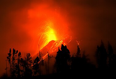

 Google Earth View")


 including in Banos, a tourist destination three miles away


")
")
")
")
")
")
")


 The United Nations health agency today reported that the cholera outbreak in Sierra Leone was escalating and stressed the need to rapidly scale up the response to the spread of the of the frequently fatal water and food-borne disease.


")
 with saturated tremor visible on the spectrogram (IG)")
 Nasa / Reuters

 MessageToEagle.com – The scientists and engineers of NASA’s Curiosity rover mission have selected the first driving destination for their one-ton, six-wheeled mobile Mars laboratory.
 MessageToEagle.com – The Milky Way galaxy is part of a larger cosmic neighborhood, consisting of more than 35 galaxies known as the Local Group.


")
 May 1, 2012 – ECUADOR – The Geophysical Institute of the National Polytechnic School today reported a slight increase in seismic activity and ash from the volcano Tungurahua. According to the Geophysical, from about 13:00 the seismic activity is characterized by the generation of a constant tremor signal, high frequency energy that remains. Also he could see a column of about 3 km emission with moderately high ash load and direction of movement to the west and south-west. Also reported minor ash falls in the sectors of El Manzano, Choglontús and Cahuají, south-west of the volcano, with almost constant roar of varying intensity. –
 “Minnesota Thunder Storm on Lake Waconia,” by Flicker user antti_nannimus


![[CANHUM]](https://i0.wp.com/si.wsj.net/public/resources/images/P1-BF989_CANHUM_G_20120430175307.jpg) Dan Janisse/Windsor StarCanadians suspect a mysterious rumble is coming from Zug Island, on the U.S. side of the Detroit River.
Dan Janisse/Windsor StarCanadians suspect a mysterious rumble is coming from Zug Island, on the U.S. side of the Detroit River.


