Category: Fire – Forest/ Wild Fires


Earth Watch Report Banner photo FSPEarthWatchReport900x228Blogger_zps53ef6af0.jpg

……………………………………………………………


Montana Kootenai National Forest Forest Fire 12.11.2015 photo Montana Kootenai National Forest Forest Fire 12.11.2015_zpsqgzgixoy.png

 Montana Kootenai National Forest Forest Fire 12.11.2015

RSOE EDIS

……….

……….

Base data

EDIS Number WF-20151211-51205-USA
Event type Forest / Wild Fire
Date/Time December 11 2015 04:22 AM (UTC)
Last update December 11 2015 04:25 AM (UTC)
Cause of event
Damage level Medium Damage level

Geographic information

Continent North-America
Country United States of America
County / State State of Montana
Area Fort Belknap area
Settlement
Coordinate 48° 28.950,108° 45.926

……….

A large grass fire is burning several miles east of Fort Belknap. There are no reports of injuries at this time; the cause of the fire is not yet known. Randy Perez tells us that the fire is heading toward Pony Hill Cemetery, and is south of Savoy Road. Perez, who lives very close to where the fire is burning, says that it is burning in mostly grass-land, with some alfalfa. He tells us that the wind pushed the fire toward Savoy Road, and the fire then changed direction. Hundreds of tons of hay have burned; at this point, no livestock are believed to have perished. The fire is believed to be about nine miles long, and more than a mile wide. Perez says that ranches have moved two herd of cattle and 100 bulls from the area to escape the approaching flames. At least ten fire trucks are at the scene, with crews responding from the MT Department of Natural Resources and Conservation, Harlem, Turner, Chinook, Dodson, Malta, and Fort Belknap. Authorities estimate that the fire has burned about 5,000 acres.

………..


Fires Continue to Burn on Kootenai National Forest

Fires in Lincoln County continue to burn and send smoke to the Flathead Valley

Unseasonably dry and warm fall weather has allowed the lightning-caused fires in the Goat Rock complex and Marston Fire to continue to burn and send smoke to the Flathead Valley.The fires in the Goat Rock complex have burned more than 22,000 acres and are located in and around the Cabinet Mountains Wilderness and Scotchman Peaks area. The Marston Fire has burned over 7,000 acres north of Trego.

While some of the fires are continuing to grow slowly, the majority of the burning is in the interior with pockets of fuel burning within the perimeter of the fires, fire managers say. These fires will continue to burn and put up smoke until the area receives significant rain and or snow.


Read More Here

………..

Earth Watch Report Banner photo FSPEarthWatchReport900x228Blogger_zps53ef6af0.jpg

……………………………………………………………………………..


Mongabay Environmental News

There have been more than 11,000 fires in just one region of the Brazilian Amazon this year

5th November 2015 / Mike Gaworecki

While climate change can certainly exacerbate drought conditions, leading to more frequent wildfires, this year’s ferocious fire season might also have been heavily influenced by the El Niño event developing in the Pacific Ocean.

  • Satellite images revealed that on October 4, 2015 there were over 900 fires burning in the Brazilian Amazon at once.
  • The region most affected by the fires was the northern state of Amazonas, where some 11,114 forest fires were recorded this year.
  • If the Pacific El Niño continues to strengthen, researchers expect fire risk in the Amazon to increase, as well.
On October 4, 2015, satellite images revealed that there were over 900 fires burning in the Brazilian Amazon.That figure was reported by Brazil’s Institute for Space Research, known as INPE, which said that the region most affected by the fires was the northern state of Amazonas. Some 11,114 forest fires have already been observed in Amazonas this year, a 47 percent increase over the same period last year, according to INPE.

Amazonas is not alone in dealing with increased incidence of forest fires. More than a quarter of the fires so far this year have occurred in the Cerrado agricultural region, which encompasses parts of the central states of Mato Grosso, Mato Grosso do Sul, Tocantins and Minas Gerais, for instance.

Meanwhile, Brazil’s southeastern states have been suffering from extreme drought, and a study by researchers at the Carnegie Institution for Science at Stanford University determined that the area of the Amazon affected by mild to severe drought is likely to double in the eastern part of Amazonia and triple in the west by 2100, due largely to the impacts of deforestation.

The Carnegie Institution researchers did not factor rising global temperatures into their calculations, however, meaning drought conditions are likely to be even worse than they projected. That does not bode well for future fire seasons being tamer than 2015.


Read More Here


………………………………………………………………………………….

the guardian

El Niño: food shortages, floods, disease and droughts set to put millions at risk

Agencies warn of unchartered territory as strongest-ever El Niño threatens to batter vulnerable countries with extreme weather for months

Indonesian workers load rice on a truck at Tanjung Priok Port in Jakarta, Indonesia, on 14 November. Indonesia will import about 1.5m tonnes of rice from Vietnam due to the impact of El Niño.
Indonesian workers load rice on a truck at Tanjung Priok Port in Jakarta, Indonesia, on 14 November. Indonesia will import about 1.5m tonnes of rice from Vietnam due to the impact of El Niño. Photograph: Bagus Indahono/EPA

The UN has warned of months of extreme weather in many of the world’s most vulnerable countries with intense storms, droughts and floods triggered by one of the strongest El Niño weather events recorded in 50 years, which is expected to continue until spring 2016.

El Niño is a natural climatic phenomenon that sees equatorial waters in the eastern Pacific ocean warm every few years. This disrupts regular weather patterns such as monsoons and trade winds, and increases the risk of food shortages, floods, disease and forest fires.

This year, a strong El Niño has been building since March and its effects are already being seen in Ethiopia, Somalia, Kenya, Malawi, Indonesia and across Central America, according to the World Meteorological Organisation. The phenomenon is also being held responsible for uncontrolled fires in forests in Indonesia and in the Amazon rainforest.

The UN’s World Meteorological Organization warned in a report on Monday that the current strong El Niño is expected to strengthen further and peak around the end of the 2015. “Severe droughts and devastating flooding being experienced throughout the tropics and sub-tropical zones bear the hallmarks of this El Niño, which is the strongest in more than 15 years,” said WMO secretary-general Michel Jarraud.

Jarraud said the impact of the naturally occurring El Niño event was being exacerbated by global warming, which had already led to record temperatures this year. “This event is playing out in uncharted territory. Our planet has altered dramatically because of climate change,” he said. “So this El Niño event and human-induced climate change may interact and modify each other in ways which we have never before experienced. El Niño is turning up the heat even further.”


Read More Here

Global Community Report Banner photo FSPLogoGlobalCommunityFulloldworldmapbckgrnd_zps43d3059c.jpg

Earth Watch Report Banner photo FSPEarthWatchReport900x228Blogger_zps53ef6af0.jpg

……………………………………………………………………………….


NaturalNews's profile photo
NaturalNews
EPA

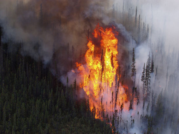
(NaturalNews) A five-year fire is burning beneath a landfill in a St. Louis suburb, and it’s rapidly approaching an old cache of nuclear waste.

At present, St. Louis County emergency officials are unsure whether or not the fire will set off a reaction that releases a radioactive plume over the city. An emergency plan was put together in October 2014 to “save lives in the event of a catastrophic event at the West Lake Landfill.”

St. Louis County officials warn, “There is a potential for radioactive fallout to be released in the smoke plume and spread throughout the region.”

Many residents are taking precautions; some are buying gas masks, while others are considering moving away. Just recently, over 500 local residents discussed the precarious situation at a church meeting which usually draws in less than 50 people.

EPA not worried about the fire or the nuclear waste

Nothing stands in the way of the uncontrollable landfill fire, which is smoldering hot underneath the trash of the West Lake Landfill of Bridgeton County, St. Louis. This “smoldering event” is not uncommon. Fires ignite and smolder under landfills because the trash becomes so compact and hot. In this case, the fire is brewing less than a quarter mile from an old deposit of nuclear waste that threatens to spread cancer-causing radon gas.

Surprisingly, the Environmental Protection Agency (EPA) isn’t taking the situation very seriously.

EPA officials admit that although the waste may eventually emit radon gas, it won’t affect anything outside the landfill property. This is the same EPA that polluted the Colorado River with 3 million gallons of toxic sludge full of lead, arsenic and other heavy metals. EPA contractors breached a mine, sending the sludge flowing into the Animas river, which quickly turned putrid and murky. That pollution has now spread to New Mexico, Utah and Arizona, infiltrating the countryside with toxic elements. Why should anyone in St. Louis County trust the EPA with radioactive waste?

To make matters worse, the EPA isn’t even worried about the fire reaching the nuclear waste. “We just do not agree with the finding that the subsurface smoldering event is approaching the radiologically impacted material,” said Mary Peterson, director of the Superfund division for EPA Region 7.

There have been no plans to remove the radioactive waste as of yet, leaving local residents baffled and worried. Most residents were unaware of the existence of the radioactive waste, which had been dumped there illegally four decades ago. If it weren’t for activists educating the public about the waste, no one would know.

Radioactive waste comes back to haunt St. Louis

The radioactive waste includes 8,700 tons of leached barium sulfate residue. It was illegally dumped in the West Lake Landfill by Cotter Corporation sometime after World War II and wasn’t discovered by investigators until 1973. The radioactive waste was left behind due to the mishandling of uranium by Mallinckrodt Chemical Works, a company that started out working for the federal government’s Manhattan Project.

Since 1990, the West Lake Landfill has been managed by the EPA and deemed a Superfund site. The U.S. Department of Health and Human Services Agency for Toxic Substances and Disease Registry recently warned all agencies not to disturb the surface of the landfill. They warned that radium-226, radon-222 and radium-228 could be released into the air, putting people near the landfill at risk.

The agency reported that radon levels in the area are often measured above regulations “by as much as 10 to 25 times at individual surface test locations.” Moreover, radium increases people’s risk of developing bone, liver and breast cancer.

The EPA is downplaying the potential for a Chernobyl or Fukushima-like disaster, but residents have every reason not to trust the agency’s guesswork, given its decades-long refusal to safely remove the radioactive material from the area.

Sources:

LATimes.com

Collapse.news

STLToday.com

WashingtonTimes.com

………………………………………………………………………………..

About NaturalNews

The NaturalNews Network is a non-profit collection of public education websites covering topics that empower individuals to make positive changes in their health, environmental sensitivity, consumer choices and informed skepticism. The NaturalNews Network is owned and operated by Truth Publishing International, Ltd., a Taiwan corporation. It is not recognized as a 501(c)3 non-profit in the United States, but it operates without a profit incentive, and its key writer, Mike Adams, receives absolutely no payment for his time, articles or books other than reimbursement for items purchased in order to conduct product reviews.

The vast majority of our content is freely given away at no charge. We offer thousands of articles and dozens of downloadable reports and guides (like the Honest Food Guide) that are designed to educate and empower individuals, families and communities so that they may experience improved health, awareness and life fulfillment.

Learn More About Natural News Here


…………………………………………………………………………………….

stl today.com

Residents demand answers about radioactive Bridgeton landfill

October 15, 2015 10:45 pm  • 

Tonya Mason, who works just feet away from the fence line of Republic Services’ landfill in Bridgeton, expresses anger that the air from burning underground material has never been tested for contaminants on Thursday, Oct. 15, 2015 at a meeting by Just Moms at John Calvin Presbyterian Church. Hundreds of people gathered to hear about the ongoing problems at the site. Photo by Christian Gooden, cgooden@post-dispatch.com

More than 40 years ago, radioactive waste was dumped at the West Lake Landfill in Bridgeton. The decades since have been filled with legal and political moves that have not gotten the site cleaned up.

Now a growing number of residents want to know how dangerous it is to live and work in the area as a fire burns underground in the adjoining Bridgeton Landfill. More than 500 people showed up at a Bridgeton church on Thursday for a meeting organized by residents. The monthly meetings held for the last two years typically attract no more than 50.

The surge in public interest comes after state reports showed the fire is moving toward the nuclear waste, and radioactive materials can be found in soil, groundwater and trees outside the perimeter of the landfill.

At least six school districts have sent letters home in the last week outlining their plans for a potential nuclear emergency. St. Louis County recently released its own emergency evacuation plan that was written last year.

Underground fires are common in landfills as buried garbage can get hot, much like the bottom of a compost pile. Typically they are monitored and allowed to burn out. But none of the fires have gotten so close to nuclear waste, which was created during the World War II era for St. Louis’ part in the production of the atomic bomb.

Read More Here


 Earth Watch Report Banner photo FSPEarthWatchReport900x228Blogger_zps53ef6af0.jpg
 ………………………………………………………………………………
Forest / Wild Fire Indonesia Province of Central Java, [Mount Merapi] Damage level Details

……….

Forest / Wild Fire in Indonesia on Monday, 02 November, 2015 at 03:56 (03:56 AM) UTC.

Description
About 200 climbers are trapped were reported trapped after forest fire in Selo District sector on Mount Merapi, Central Java. Tempo gathered information that fire first appeared around 9 am Sunday, November 1, on a cliff around Pos 1, then the fire began to spread but not close the climbing lane. Head of Disaster Management Operation Control Center (Pusdalops) of the Boyolali Regional Disaster Management Agency (BPBD) Kurniawan Fajar Prasetyo said together with a SAR team and local residents, they are trying to evacuate the climbers. “We are trying that all hikers can go down,” he said Sunday. According to Kurniawan, about 300 climbers went off, most of them departed from the Barameru Post, Selo, on Friday last week. So far around 100 people have been evacuated. Kurniawan said, health condition of the climbers that were evacuated are well. Some of them immediately return to their homes, some of them are staying to wait for their friends who are still trapped. While evacuating climbers, officers are fighting fire around Post 1. Kurniawan said if fire is not immediately extinguished, it could expand and close the climbing lane. Cause and the extent of the fire is not immediately known.

……….

The Huffington Post

Indonesian Forest Fires Have Been Burning Since August

Posted: 02/11/2015 16:07 AEST Updated: 2 hours ago
INDONESIA FIRE

Millions of acres of pristine, irreplaceable and invaluable Indonesian forest has been reduced to smouldering blackened ash, as 100,000 fires rage through the island region.

The sheer size and scale of the fire crisis is difficult to properly comprehend. Some of these fires have been burning since August, torching forest eons old and blanketing Papua, Singapore, Kuala Lumpur and countless islands of Indonesia in thick grey hazy smoke.

The World Resources Institute reports a staggering 127,000 fires have been reported in the region in 2015, the majority sparking and taking off in recent months.

Pictures from NASA’s Earth Observatory, show the extent of smoke from the fires — these images were taken over Borneo.

borneo\Smoke over Borneo

Earlier in October, Indonesia’s Forestry Ministry reported 4.2 million acres of forest had been burnt out, a figure which is sure to have risen since first reported.

Carbon emissions from the fires, at their peak, surpassed emissions belched out by the entire United States of America. More than half a million people have reported respiratory problems.


Read More Here

……….


……….


……….

Earth Watch Report Banner photo FSPEarthWatchReport900x228Blogger_zps53ef6af0.jpg

………………………………………………………………………………

Discovery News

El Nino May Bring Civil Unrest This Winter

//

When an unusually powerful El Niño struck in 1997, civil conflicts erupted across the tropics, from Sudan to Peru — as floods, droughts and fires devastated crops, fisheries and livelihoods.

It wasn’t an isolated case, suggests growing evidence that links El Niño’s extreme weather with a spike in violent conflicts in tropical regions. As one of the strongest El Niño events in recorded history gains steam this fall, some experts are warning of the potential for more unrest to come – and the urgent need to take preventive action.

Play Video
Some fairly nutty and violent weather can occur during El Nino years.
DCI

“Half the world’s population is exposed to a higher risk of violence this year,” says Solomon Hsiang, professor of public policy at Berkeley. “Now that we know what to expect, we shouldn’t necessarily sit back and watch sparks fly. There are a lot of things we can do.”

Civilizations That Withered in Drought

Collapses of entire civilizations have been linked to climate shifts, with examples that go back centuries. The Little Ice Age in the mid-1600s, for example, has been blamed for widespread wars and political crises that occurred around much of the world at the time.


Read More Here

Earth Watch Report Banner photo FSPEarthWatchReport900x228Blogger_zps53ef6af0.jpg

………………………………………………………………………………

Yahoo News

Associated Press

Associated Press Videos

Raw: Texas Wildfire Covers Six Square Miles

Raw: Texas Wildfire Covers Six Square Miles

AUSTIN, Texas (AP) — The worst of a rural Texas wildfire that has destroyed nearly 50 structures is likely over as firefighters make big strides containing more than 7 miles of scorched and bone-dry forestland, authorities said Friday.

Some residents remain unable to return to their homes on barricaded roads in Bastrop County. But officials said the fire that began Tuesday and grew big enough to waft smoke into downtown Austin, some 40 miles away from the fire, now appears to be getting under control.

“Barring some totally unforeseen circumstance, we’re on the downhill side of this fire,” Bastrop County Judge Paul Pape said.


Read More and Watch Video Here

Earth Watch Report Banner photo FSPEarthWatchReport900x228Blogger_zps53ef6af0.jpg

………………………………………………………………………………

Earth Watch Report Banner photo FSPEarthWatchReport900x228Blogger_zps53ef6af0.jpg

********************************************************

EarthSky

Worst recorded years for U.S. wildfires are 2005, 2006, 2007, 2011 and 2012. This year has already joined that list, and wildfire season is still going strong.

Trees engulfed in flames at the Tetlin National Wildlife Refuge in Alaska. Image Credit: U.S. Fish and Wildlife Service.

The ongoing drought in the U.S. West is not helping the wildfire situation in 2015. Current info about 2015's drought in the U.S. here

The 2015 wildfire season in the United States has already broken records. So far this year, more acres of land have burned as of mid-September than the total annual amount in 2011, which was the 4th worst year for wildfires at least since the 1960s. So will this year be the new fourth worst, third worst, second worst, or worst wildfire year since then? Read on, and take a guess.

The National Interagency Fire Center in Boise, Idaho, publishes a ton of useful statistics on wildfires that are critical for helping state and federal agencies manage the flames. These records date back to the 1960s.

The chart below, created with the National Interagency Fire Center data, shows that the worst years for wildfires in the U.S., since these records began being kept, were 2006 (9,873,745 acres burned), 2007 (9,328,045 acres burned), 2012 (9,326,238 acres burned), 2011 (8,711,367 acres burned), and 2005 (8,689,389 acres burned).

Already as of September 18, 2015, 8,821,040 acres of land have burned across the U.S., and this number exceeds the total number of acres burned for 2011. Hence, 2015 has already earned a spot as the 4th worst year on record, and the 2015 wildfire season is still going strong.


Read More Here

Earth Watch Report  –  Nuclear Event


…..

Nuclear Event USA State of California, [San Onofre nuclear power plant] Damage level Details


…..

RSOE EDIS

Nuclear Event in USA on Thursday, 15 May, 2014 at 17:56 (05:56 PM) UTC.

Description
An out-of-control brush fire at Camp Pendleton was creeping closer to the San Onofre nuclear power plant, prompting evacuations. Southern California Edison said in a tweet that “about a dozen non-essential employees evacuated” from the plant because of the fire. The plant is located off Interstate 5 at the Orange-San Diego county line north of Camp Pendleton. Edison announced last year it was closing the plant due to structural problems with facility. The Camp Pendleton fire was spotted shortly before 10 a.m. Wednesday and forced evacuations of the De Luz housing area, Mary Fay Pendleton Elementary School and the Naval Weapons Station Fallbrook, which is on the northeast edge of the sprawling base. A second school and housing area have been evacuated as the brush fire at Camp Pendleton continues to spread. The fire, dubbed the Tomahawk fire, on the northeast section of the base, had burned more than 150 acres as of 1 p.m., according to Cal Fire. An evacuation center was established at the Paige Fieldhouse on the base. The Pendleton fire was one of several blazes burning in San Diego County. One in Carlsbad has burned homes. More than 11,500 evacuation notices have been issued for the fire as it moves through neighborhoods amid steep brushy canyons.


…..

L.A. Now

Fire forces evacuation of San Onofre nuclear plant

An out-of-control brush fire at Camp Pendleton was creeping closer to the San Onofre nuclear power plant, prompting evacuations.

Southern California Edison said in a tweet that “about a dozen non-essential employees evacuated” from the plant because of the fire.

The plant is located off Interstate 5 at the Orange-San Diego county line north of Camp Pendleton. Edison announced last year it was closing the plant due to structural problems with facility.

The Camp Pendleton fire was spotted shortly before 10 a.m. Wednesday and forced evacuations of the De Luz housing area, Mary Fay Pendleton Elementary School and the Naval Weapons Station Fallbrook, which is on the northeast edge of the sprawling base.


Read More Here


…..

Return to FOX5 San Diego – San Diego news, weather, traffic, sports from KSWB home page

Huge Pendleton fires nearly contained

CAMP PENDLETON, Calif. — Firefighters continued making progress Sunday containing three fires that have blackened 21,900 acres on Camp Pendleton and Naval Weapons Station Fallbrook.

The largest of the fires, the fast-moving Las Pulgas Fire, had burned about 15,000 acres since it erupted for unknown reasons at about 3:15 p.m. on Thursday near a sewage plant in Camp Las Pulgas. The blaze was 75 percent contained Sunday afternoon, according to officials.

Camp pendleton fires

The first fire reported, the so-called Tomahawk Fire, broke out at Naval Weapons Station Fallbrook at the eastern outskirts of Camp Pendleton at about 9:45 a.m. on Wednesday and later spread to the Marine base. It was 100 percent contained Sunday and had blackened about 5,400 acres.

The most recent blaze to break out at Camp Pendleton, dubbed the San Mateo Fire, began spreading just before 11:30 a.m. on Friday near Basilone Road. It had grown to about 1,500 acres today and was 97 percent contained, according to base officials.

Gen. James F. Amos, the Commandant of the Marine Corps, and Brig. Gen. John W. Bullard, the Marine Corps Installations West commanding general, were briefed today on the three fires — known collectively as the Basilone Complex – – at Camp Pendleton. Amos and Sgt. Maj. Michael P. Barrett, sergeant major of the Marine Corps, also spoke with firefighters working to extinguish the blazes.


Read More Here

…..

Enhanced by Zemanta

KING 5.com


Climate change increasing massive wildfires in West

Climate change increasing massive wildfires in West

Credit: Draysen Brooks Bechard

Wildfire near Wenatchee, 2013.

by Doyle Rice, USA TODAY

Posted on April 19, 2014 at 11:06 AM

Updated today at 11:09 AM


Massive wildfires are on the increase in the Western US due to rising temperatures and worsening drought from climate change, and the trend could continue in the decades to come, new research suggests.

Overall, the number of large wildfires increased by a rate of seven fires a year from 1984 to 2011, while the total area damaged by fire increased at a rate of nearly 90,000 acres per year, according to the study, published this week in Geophysical Research Letters, a journal of the American Geophysical Union (AGU).

The study comes against the backdrop of what could to be a disastrous year for fires in the West, especially drought-plagued California, which even saw fires in the normally quiet month of January.

Though relatively calm this week, “Expect dry and windy conditions to develop over the Southwest Tuesday and Wednesday,” according to a forecast Friday from the National Interagency Fire Center in Boise. By May, “Above normal significant fire potential will expand over portions of Southern, Central and Northern California,” the NIFC predicted earlier this month.


Read More Here

Enhanced by Zemanta