Category: Extreme Temperatures


Earth Watch Report Banner photo FSPEarthWatchReport900x228Blogger_zps53ef6af0.jpg

………………………………………………………..

Today's Zaman

Meteorology directorate warns against heavy snowfall across Turkey

Meteorology directorate warns against heavy snowfall across Turkey

The Central Anatolian city of Sivas was quickly covered by heavy snow on Wednesday. There has also been snowfall in the capital, Ankara. (Photo: Cihan)


December 02, 2015, Wednesday/ 18:40:36/ TODAY’S ZAMAN / ISTANBUL

The General Directorate of Meteorology has released a statement saying that heavy snowfall is expected in Turkey on Wednesday night and warns of traffic-related problems.

The warning came after snow started falling in the capital city of Ankara early on Wednesday, covering the city in a short time. There has also been snowfall in Kayseri, Nevşehir, Sivas and Yozgat provinces.

As the snowfall intensified in Bolu and Ankara, highway maintenance teams shoveled the snow and salted the roads trying to open up the blocked highways, especially the TEM and D-100 near Bolu. The police also advised that people residing in these provinces should be careful when driving.

The directorate emphasized in its statement that heavy snowfall and blizzards will be seen on Thursday in some provinces that include Ağrı, Bitlis, Hakkari and Van and in the eastern parts of Şırnak, Siirt and Muş. “People [residing in these provinces] should be careful about possible ice and frost that might cause problems to traffic,” the statement read.


Read More Here

Earth Watch Report Banner photo FSPEarthWatchReport900x228Blogger_zps53ef6af0.jpg

………………………………………………………..


  • By Slma Shelbayah and Kimberly Hutcherson CNN

    10 dead as wintry storm hits Plains

    Millions under winter weather, flood warnings

    UPDATED 4:59 PM CST Nov 29, 2015
    OK ice storm 11.29.15
    CNN KOCO

    (CNN) —The governor of Oklahoma, Mary Fallin, has declared a state of emergency for her state, according to KOCO.

This follows an ice storm and flooding that has knocked out power for thousands of people throughout the state.

Meanhwhile, flooding and wintry precipitation have led to at least 10 deaths in Texas and Kansas as a storm system moves across the central Plains, authorities reported.

Five people died in single-vehicle accidents in Kansas, according to Lt. Adam Winters with the state’s Highway Patrol. He said all of the accidents could be attributed to black ice or hazardous road conditions.

Flooding claimed at least three lives in the Dallas area. The victims include a man in Garland, northeast of Dallas. Benjamin Floyd, 29, was on his way to work when raging floodwaters swept his car off the road, according to CNN affiliate KTVT. He was unable to get out of his vehicle before it was submerged Friday, Garland city officials said.

The two other flooding deaths came in Johnson County, south of Fort Worth, county emergency management officials said.

The National Weather Service reported ice storms in the Texas Panhandle. Three people died in a road accident on Interstate 40 about 45 miles west of Amarillo, the weather service reported.


Read More Here

Earth Watch Report Banner photo FSPEarthWatchReport900x228Blogger_zps53ef6af0.jpg

………………………………………………………


Eyewitness News

Major increase in weather disasters over last 2 decades

Since 1995, weather disasters have killed millions of people & left billions injured & homeless.

A flood-affected resident swims through floodwaters in Kalay, upper Myanmar’s Sagaing region on August 3, 2015. Relentless monsoon rains have triggered flash floods and landslides, destroying thousands of houses, farmland, bridges and roads with fast-flowing waters hampering relief efforts. Picture: AFP.


GENEVA – Weather-related disasters such as floods and heatwaves have occurred almost daily in the past decade, almost twice as often as two decades ago, with Asia being the hardest hit region, a UN report said on Monday.

While the report authors could not pin the increase wholly on climate change, they did say that the upward trend was likely to continue as extreme weather events increased.

Since 1995, weather disasters have killed millions of people, left billions injured, homeless or in need of aid, and accounted for 90 percent of all disasters, it said.

A recent peak year was 2002, when drought in India hit 200 million and a sandstorm in China affected 100 million.

But the standout mega-disaster was Cyclone Nargis, which killed 138,000 in Myanmar in 2008.


Read More Here

Earth Watch Report Banner photo FSPEarthWatchReport900x228Blogger_zps53ef6af0.jpg

…………………………………………………………………………………


Chronicle

North East braced for cold snap as Met Office warns of snow


Snow falls on the Millennium Bridge. Photo Dave Charlton February 2009
Snow falls on the Millennium Bridge in 2009

A cold snap will grip much of the North East throughout this weekend, with forecasters warning of gale-force winds, snow and hazardous driving conditions.

The Met Office has said a band of rain, sleet and snow will move south across Northern and Eastern Scotland on Friday afternoon, reaching North East England at night.

The snow will mainly affect higher ground at first, but by Friday night up to four centimetres could fall at lower levels.

Forecasters warned: “Wintry showers will spread to many Northern areas in particular and night frosts will become much more widespread.”

Chris Hogan, from MeteoGroup, said Friday will deliver blustery showers, but the conditions will deteriorate into Saturday morning.


Read More Here

Earth Watch Report Banner photo FSPEarthWatchReport900x228Blogger_zps53ef6af0.jpg

……………………………………………………………………………….


Iceland in grips of cold snap

Frost and snow in parts of Iceland today.

Frost and snow in parts of Iceland today. Photo: Rax

Anybody venturing outside in Iceland yesterday evening will have found that predictions of bitterly cold weather were not exaggerated.

Even the most extreme forecast minimum temperature was reached – it was exactly -20°C at the Icelandic Met Office weather station at Sandbúðir in inland South-East Iceland early this morning.

It is currently -9°C in the capital Reykjavik and temperatures will struggle to exceed -4°C at their very warmest today.


Read More Here

Earth Watch Report Banner photo FSPEarthWatchReport900x228Blogger_zps53ef6af0.jpg

……………………………………………………………………………..


Mongabay Environmental News

There have been more than 11,000 fires in just one region of the Brazilian Amazon this year

5th November 2015 / Mike Gaworecki

While climate change can certainly exacerbate drought conditions, leading to more frequent wildfires, this year’s ferocious fire season might also have been heavily influenced by the El Niño event developing in the Pacific Ocean.

  • Satellite images revealed that on October 4, 2015 there were over 900 fires burning in the Brazilian Amazon at once.
  • The region most affected by the fires was the northern state of Amazonas, where some 11,114 forest fires were recorded this year.
  • If the Pacific El Niño continues to strengthen, researchers expect fire risk in the Amazon to increase, as well.
On October 4, 2015, satellite images revealed that there were over 900 fires burning in the Brazilian Amazon.That figure was reported by Brazil’s Institute for Space Research, known as INPE, which said that the region most affected by the fires was the northern state of Amazonas. Some 11,114 forest fires have already been observed in Amazonas this year, a 47 percent increase over the same period last year, according to INPE.

Amazonas is not alone in dealing with increased incidence of forest fires. More than a quarter of the fires so far this year have occurred in the Cerrado agricultural region, which encompasses parts of the central states of Mato Grosso, Mato Grosso do Sul, Tocantins and Minas Gerais, for instance.

Meanwhile, Brazil’s southeastern states have been suffering from extreme drought, and a study by researchers at the Carnegie Institution for Science at Stanford University determined that the area of the Amazon affected by mild to severe drought is likely to double in the eastern part of Amazonia and triple in the west by 2100, due largely to the impacts of deforestation.

The Carnegie Institution researchers did not factor rising global temperatures into their calculations, however, meaning drought conditions are likely to be even worse than they projected. That does not bode well for future fire seasons being tamer than 2015.


Read More Here


………………………………………………………………………………….

the guardian

El Niño: food shortages, floods, disease and droughts set to put millions at risk

Agencies warn of unchartered territory as strongest-ever El Niño threatens to batter vulnerable countries with extreme weather for months

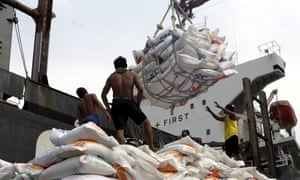
Indonesian workers load rice on a truck at Tanjung Priok Port in Jakarta, Indonesia, on 14 November. Indonesia will import about 1.5m tonnes of rice from Vietnam due to the impact of El Niño.
Indonesian workers load rice on a truck at Tanjung Priok Port in Jakarta, Indonesia, on 14 November. Indonesia will import about 1.5m tonnes of rice from Vietnam due to the impact of El Niño. Photograph: Bagus Indahono/EPA

The UN has warned of months of extreme weather in many of the world’s most vulnerable countries with intense storms, droughts and floods triggered by one of the strongest El Niño weather events recorded in 50 years, which is expected to continue until spring 2016.

El Niño is a natural climatic phenomenon that sees equatorial waters in the eastern Pacific ocean warm every few years. This disrupts regular weather patterns such as monsoons and trade winds, and increases the risk of food shortages, floods, disease and forest fires.

This year, a strong El Niño has been building since March and its effects are already being seen in Ethiopia, Somalia, Kenya, Malawi, Indonesia and across Central America, according to the World Meteorological Organisation. The phenomenon is also being held responsible for uncontrolled fires in forests in Indonesia and in the Amazon rainforest.

The UN’s World Meteorological Organization warned in a report on Monday that the current strong El Niño is expected to strengthen further and peak around the end of the 2015. “Severe droughts and devastating flooding being experienced throughout the tropics and sub-tropical zones bear the hallmarks of this El Niño, which is the strongest in more than 15 years,” said WMO secretary-general Michel Jarraud.

Jarraud said the impact of the naturally occurring El Niño event was being exacerbated by global warming, which had already led to record temperatures this year. “This event is playing out in uncharted territory. Our planet has altered dramatically because of climate change,” he said. “So this El Niño event and human-induced climate change may interact and modify each other in ways which we have never before experienced. El Niño is turning up the heat even further.”


Read More Here

Earth Watch Report Banner photo FSPEarthWatchReport900x228Blogger_zps53ef6af0.jpg

………………………………………………………………………………..


Business Insider

This year’s El Niño is shaping up to be one of the most powerful on record

el ninoNOAA

If you’ve been paying attention to the weather news at all lately, you’ll know that it’s a big year for a weather event called El Niño.

The complex phenomenon could bring warmer, wetter weather to the Northeast this winter and much-needed rain to California, but worsen cold and drought conditions elsewhere in the US.

And this year’s El Niño could be one of the most powerful on record, experts say.

“One of the strongest El Niño events in the past 65 years is likely to bring significant winter weather to the United States,” James Aman, senior meteorologist at Earth Networks, said in a statement.

What the heck is El Niño, anyway?

El Niño is a weather event characterized by warmer-than-normal temperatures in the equatorial Pacific Ocean, with important consequences for global weather and climate, according to the National Oceanic and Atmospheric Administration. By contrast, La Niña refers to colder-than-normal Pacific temperatures.

The effects of El Niño can be seen across the globe, from increased rainfall in the Southern US and Peru to drought in the Western Pacific and brush fires in Australia.


Read More Here

Earth Watch Report Banner photo FSPEarthWatchReport900x228Blogger_zps53ef6af0.jpg

Global Community Report Banner photo FSPLogoGlobalCommunityFulloldworldmapbckgrnd_zps43d3059c.jpg

………………………………………………………………………………..

Queen Mary's Psalter shows men harvesting in 14th century Europe

Climatologists Piece Together a Millennium of Droughts and Downpours

© Photo: Wikimedia commons
Environment
22:00 07.11.2015(updated 22:08 07.11.2015) 

The new Old World Drought Atlas of droughts and wet weather in the Old World gives climate scientists greater perspective on current weather phenomenon.

Climate scientists have produced an atlas reconstructing weather conditions over the last millennium, in an effort to understand more about current changes to the weather.They hope their Old World Drought Atlas (OWDA) will allow for a greater understanding of climate forecasts.

“Climate model projections suggest widespread drying in the Mediterranean Basin and wetting in Fennoscandia in the coming decades largely as a consequence of greenhouse gas forcing of climate,” write the scientists in their paper, published in Science Advances on Friday.

The researchers used archaeological tree ring data to measure more than a thousand years of European weather. They compared their findings to historical accounts of severe droughts, wet weather events or other catastrophes, and found that the tree ring data corresponds with many documented incidents of extreme weather.

……………………………………….

The 700 Year Old Weather Chart That Gives Me Butterflies

Posted by Dan Satterfield

Oh, and look at 1741, and the terrible drought. The trees are showing the results of the cold and dry spell that began in 1739. This is the year of the great Irish famine, and it killed millions as well. Here’s what the paper has to say about the 1741 map:

The Irish famine of 1740–1741: This event has been attributed to unusually low winter and spring temperatures in 1740, resulting in crop failures and subsequent famine (17). The OWDA is not well suited for determining temperature anomalies because it primarily reflects warm season hydroclimate. However, climate field reconstructions of seasonal precipitation from documentary and early instrumental data (18) indicate that spring-summer rainfall over Ireland in 1741 was well below normal relative to the modern average. Drought over Ireland may therefore have contributed to the severity of the famine through its negative impact on food production in 1741. The OWDA map of 1741  indicates severe drought over Ireland that also extended over England and Wales, consistent with previously reported record rainfall deficits.


Fig. 2 OWDA maps of known years of hydroclimatic extremes

Is it just me, or does this give you the willies? It’s like looking at that big high pressure over the NW Atlantic on the night of April 14,1912. The Titanic survivors reported the ocean as still as a mill-pond, and I have the surface weather map that proves they were right. That’s how I feel about these rainfall charts. That horrible famine was seven long centuries ago, but the trees still remember, and they tell us that those old faded pieces of parchment were not exaggerating. It was real, and it left millions dead, and millions more in grief.


This Old World Drought Atlas will have great benefits in climate research, and historians will find them invaluable as well, but they also give us a warning. Our limited 100 years or so of written weather records can be deceiving. We think we know what a bad crop year is, and how long a bad drought can last, but our lifetimes are rather short, and perhaps we are fools. Knowing this makes fooling with our planet’s temperature control even more egregious.

The paper is open access and you can read it all HERE.


Read More Here


Earth Watch Report Banner photo FSPEarthWatchReport900x228Blogger_zps53ef6af0.jpg

……………………………………………………………………………….


An intolerable unimaginable heat forecast for Persian Gulf

Associated Press

FILE In this June 10, 2010 file photo, an Asian laborer avoids the direct sun by working behind a wooden sign, as he works on a manhole alongside of an under construction road in Dubai, United Arab Emirates. Parts of the Persian Gulf by the end of the century will on occasion will be just too hot for the human body to tolerate, if carbon dioxide emissions continue on current trend, a new study says. (AP Photo/Kamran Jebreili, File)
.
FILE In this June 10, 2010 file photo, an Asian laborer avoids the direct sun by working behind a wooden sign, as he works on a manhole alongside of an under construction road in Dubai, United Arab Emirates. Parts of the Persian Gulf by the end of the century will on occasion will be just too hot for the human body to tolerate, if carbon dioxide emissions continue on current trend, a new study says. (AP Photo/Kamran Jebreili, File)

WASHINGTON (AP) — If carbon dioxide emissions continue at their current pace, by the end of century parts of the Persian Gulf will sometimes be just too hot for the human body to tolerate, a new study says.

How hot? The heat index — which combines heat and humidity — may hit 165 to 170 degrees (74 to 77 Celsius) for at least six hours, according to numerous computer simulations in the new study. That’s so hot that the human body can’t get rid of heat. The elderly and ill are hurt most by current heat waves, but the future is expected to be so hot that healthy, fit people would be endangered, health experts say.

“You can go to a wet sauna and put the temperature up to 35 (Celsius or 95 degrees Fahrenheit) or so. You can bear it for a while, now think of that at an extended exposure” of six or more hours, said study co-author Elfatih Eltahir, an MIT environmental engineering professor.

While humans have been around, Earth has not seen that type of prolonged, oppressive combination of heat and humidity, Eltahir said. But with the unique geography and climate of the Persian Gulf and increased warming projected if heat-trapping gas emissions continue to rise at current rates, it will happen every decade or so by the end of the century, according to the study published Monday in the journal Nature Climate Change.


Read More Here

Earth Watch Report Banner photo FSPEarthWatchReport900x228Blogger_zps53ef6af0.jpg

……………………………………………………………………………..

Unseasonal Snowfall Brings Winter in October in Parts of Kashmir

Met department officials say they have no record of heavy snowfall in the Valley during the month of October

Srinagar:  Even though it’s the middle of autumn, in parts of Kashmir it seems like winter. Cold temperatures have brought unseasonal snowfall at higher reaches of the valley.

For last two days Mughal Road that connects Kashmir valley with Pirpanjal region has remained closed and hundreds of trucks were stranded along the key passage.

At an altitude of 11,000 feet, Peer Ki Gali, the highest spot on Mughal Road has seen about two feet of snowfall in last 48 hours. But as the weather improved today and sun came out, officials increased their efforts to clear the road.

“Snow clearance machines are at work since yesterday and road will be fully functional today. We have already cleared over 500 trucks yesterday evening,” said Nisar Ahmad, an engineer at Mughal Road.

Read More Here