A horrifying video of a landslide swallowing up the city of Shenzhen in southern China shows entire buildings being gobbled up in seconds. Meanwhile, the number of people missing has jumped to 91, China Central Television (CCTV) reports.
The disaster occurred in the Hengtaiyu industrial park in Shenzhen, Guangdong province, on Sunday morning, destroying a total of 22 buildings and causing a gas pipeline explosion.
Shocking video footage from CCTV shows an entire multi-level building collapse in under five-seconds. At first, people are in disbelief, but are then seen running away from the landslide seeking safety.
China’s Ministry of Land & Resources has blamed the disaster on a collapse of piled-up construction waste and soil residue in the area, state media said. It also cited a local emergency office giving a sharply increased estimate of the number of people missing. The figure had previously stood at 59.
Watch: Tourists defy death at Manali-Chandigarh highway
Last Updated: Monday, December 7, 2015 – 15:50
Zee Media Bureau
New Delhi: Several tourists on had a narrow escape when a part of a mountain near Chandigarh-Manali highway collapsed. The 31-second video, recorded by a mobile phone camera, shows tourists running for their lives.
Initially, it was said that the landslide was caused due to an earthquake today in the region, but later it was clarified that the incident has no connection with the earthquake.
I cover science and innovation and products and policies they create.
Opinions expressed by Forbes Contributors are their own.
A NASA image from 2014
It’s not exactly a Pacific beach resort just yet, but the Japanese Coast Guard reports that a volcanic island that first popped up in the middle of the ocean two years ago has already grown to twelve times its initial size.
Molten rock cooled by the ocean first poked out of the water in November, 2013, when it was initially spotted next to island Nishinoshima, which it eventually grew to engulf.
Tens of thousands of years ago, an undersea volcano a thousand kilometers south of Tokyo reached a milestone: Its peak reached the surface of the Pacific Ocean. It became an actual island. For millennia it slept, but in the 1970s a series of eruptions grew the island, which was named Nishinoshima. It was tiny, just a couple of hundred meters across.
But then there were a series of eruptions just south of the island in November 2013, in a still-submerged part of the volcano. This created a second peak, which poked through the water’s surface to become a new island just a few hundred meters from Nishinoshima.
That wouldn’t last: The new island grew as the volcano continued to erupt, and just before New Year’s Day 2014, the new island grew so big it actually connected to the old island. Now there is just one … and it’s still erupting, as you can see in this lovely image taken by the Landsat 8 satellite on March 20, 2014:
The new volcanic Nishinoshima Island, seen FROM SPAAAAACE. Click to hephaestenate.
A recent study found that the historical occurrence of earthquakes in the eastern Mediterranean Sea has been much more plentiful than previously thought. They have suggestions for precautions to take, considering that. (Photo : Wikimedia Commons)
There is more seismic activity in the eastern Mediterranean than was previously thought, and a study about this was recently accepted for publication in the journal Geophysical Research Letters.
Historically in the long stretch of geological time, seismic activity near and around Crete has stirred up bursts of earthquakes, and this may increase the region’s future risk of earthquakes and tsunamis, according to a release.
Several tectonic plates are in the Mediterranean basin, caused by the African and Eurasian Plates crashing together there. While scientists have been aware that the collision between the two plates can make the eastern part of that sea and land area susceptible to earthquakes, they’ve also been confused by the region having gone through only two (known) earthquakes larger than 8 on the Richter scale in 4,000 years.
The African Plate goes under the Aegean microplate just south of Crete. This occurs in an area shaped like an arc, which is called the Hellenic margin. The scientists in the study looked at the history of earthquakes in this subduction zone, to learn what could drive mega-earthquakes in the area.
“We study the Hellenic subduction margin going back to about 50,000 years, which is about 10 times the time window of paleo-earthquake observations in the eastern Mediterranean that we had before,” Vasiliki Mouslopoulou, at the GFZ German Research Center for Geosciences, and study lead author, in the release. “For the first time ever, we were able to chart the spatial and temporal pattern with which mega-earthquakes rupture the Hellenic margin.”
Sky5 aerials show a buckling Vasquez Canyon Road in Canyon Country. (Credit: KTLA)
A portion of Vasquez Canyon Road remained closed indefinitely Friday after a landslide prompted buckling and significant damage along a 2-mile stretch in the Canyon Country area.
KTLA reporter Mark Mester stands next to Vasquez Canyon Road, which continued to buckle on Nov. 20, 2015. (Credit: KTLA)
“This isn’t just the road; it’s the mountain itself that’s moving and it’s pushing the road up,” said Paul Funk with L.A. County Department of Public Works.
The roadway was closed Thursday between Lost Creek Road and Vasquez Way after public works officials first noticed the shift around 10:30 that morning.
The closure was said to be indefinite and would likely last for “a long time,” Funk said.
In less than 24 hours, the roadway changed from appearing slightly tilted to being very badly damaged.
More than half the road was lifted some 15 feet in the air, with dirt from the neighboring hillside sliding underneath and causing significant cracks.
Geoscientists have for the first time revealed the magma plumbing beneath Mount St. Helens, the most active volcano in the Pacific Northwest. The emerging picture includes a giant magma chamber, between 5 and 12 kilometers below the surface, and a second, even larger one, between 12 and 40 kilometers below the surface. The two chambers appear to be connected in a way that could help explain the sequence of events in the 1980 eruption that blew the lid off Mount St. Helens.
So far the researchers only have a two-dimensional picture of the deep chamber. But if they find it extends to the north or south, that would imply that the regional volcanic hazard is more distributed rather than discrete, says Alan Levander, a geophysicist at Rice University in Houston, Texas, and a leader of the experiment that is doing the subterranean imaging. “It isn’t a stretch to say that there’s something down there feeding everything,” he adds.
Levander unveiled the results on 3 November at a meeting of the Geological Society of America in Baltimore, Maryland—the first detailed images from the largest-ever campaign to understand the guts of a volcano with geophysical methods. The campaign, “imaging magma under St. Helens” (iMUSH), started in 2014 when researchers stuck 2500 seismometers in the ground on trails and logging roads around the volcano. They then detonated 23 explosive shots, each with the force of a small earthquake. “You’d feel this enormous roll in the ground, and everyone would go, ‘Oh wow’,” Levander says.
IMUSH: MAGMA RESERVOIRS FROM THE UPPER CRUST TO THE MOHO INFERRED FROM HIGH-RESOLUTION VP AND VS TOMOGRAPHY BENEATH MOUNT ST. HELENS
KISER, Eric1, LEVANDER, Alan2, PALOMERAS, Immaculada1, ZELT, Colin A.1, SCHMANDT, Brandon3, HANSEN, Steven3, HARDER, Steven4, CREAGER, Kenneth5 and VIDALE, John E.5, (1)Earth Science, Rice University, 6100 Main Street, Houston, TX 77005, (2)Earth Science, Rice University, 6100 Main Street MS-126, Houston, TX 77005, (3)Earth & Planetary Sciences, University of New Mexico, Albuquerque, NM 87131, (4)Dept. of Geological Sciences, University of Texas at El Paso, 500 W. University Ave., El Paso, TX 79968, (5)Earth & Space Sciences, University of Washington, Johnson Hall Rm-070 Box 351310, 4000 15th Avenue NE, Seattle, WA 98195, alan@rice.edu
Seismic investigations following the 1980 eruption of Mount St. Helens have led to a detailed model of the magmatic and tectonic structure directly beneath the volcano. These studies suffer from limited resolution below ~10 km, making it difficult to estimate the volume of the shallow magma reservoir beneath the volcano, the regions of magma entry into the lower crust, and the connectivity of this magma system throughout the crust. The latter is particularly interesting as one interpretation of the Southern Washington Cascades Conductor (SWCC) suggests that the Mount St Helens and Mount Adams volcanic systems are connected in the crust (Hill et al., 2009).
The multi-disciplinary iMUSH (imaging Magma Under St. Helens) project is designed to investigate these and other fundamental questions associated with Mount St. Helens. Here we present the first high-resolution 2D Vp and Vs models derived from travel-time data from the iMUSH 3D active-source seismic experiment. Significant lateral heterogeneity exists in both the Vp and Vs models. Directly beneath Mount St. Helens we observe a high Vp/Vs body, inferred to be the upper/middle crustal magma reservoir, between 4 and 13 km depth. Southeast of this body is a low Vp column extending from the Moho to approximately 15 km depth. A cluster of low frequency events, typically associated with injection of magma, occurs at the northwestern boundary of this low Vp column. Much of the recorded seismicity between the shallow high Vp/Vs body and deep low Vp column took place in the months preceding and hours following the May 18, 1980 eruption. This may indicate a transient migration of magma between these two reservoirs associated with this eruption.
Outside of the inferred magma bodies that feed Mount St. Helens, we observe several other interesting velocity anomalies. In the lower crust, high Vp features bound the low Vp column. One explanation for these features is the presence of lower crustal cumulates associated with Tertiary ancestral Cascade volcanism. West of Mount St. Helens, high Vp/Vs regions in the upper and middle crust have eastern boundaries that are close to the eastern boundaries of the accreted Siletzia terrain inferred from magnetic data. Finally, a low Vp channel northeast of Mount St. Helens between 14 and 18 km depth correlates well with the location of the SWCC.
Its scarred and jagged crater is a reminder of the terrible devastation that Mount St Helens wrought over the Washington countryside 35 years ago.
Now a new study of the volcanic plumbing lurking beneath the 8,363ft (2,459 metre) summit suggests the volcano could yet again blow its top in an explosive eruption.
Geologists studying the volcano, which is responsible for the most deadly eruption in US history, have discovered a second enormous magma chamber buried far beneath the surface.
The IMUSH project has detected signs that a second larger magma chamber may lie beneath Mount St Helens, filling the chamber directly under the volcano from below (illustrated) through a series of earthquakes. The chamber may also connect Mount St Helens to other nearby volcanoes
The American Dream Is Becoming A Nightmare And Life As We Know It Is About To Change
By Michael Snyder, on November 1st, 2015
More than 25 million people live in the vicinity of North America’s 2nd-highest volcano, and in recent weeks this volcano has been steadily rumbling and has been spewing out massive amounts of black smoke and ash. I have previously written about “the most dangerous mountain in the United States” (Mt. Rainier), but if the volcano that I am talking about today experiences a full-blown explosive eruption it could potentially be a cataclysmic event beyond what most of us would dare to imagine. Popocatepetl is an Aztec word that means “smoking mountain”, and it is also the name of a giant volcano that sits approximately 50 miles away from Mexico City’s 18 million residents. “Popo”, as it is called by locals, was dormant for much of the 20th century, but it came back to life in 1994. And now all of this unusual activity in recent weeks has many wondering if a major eruption may be imminent.
Historians tell us that Popocatepetl had a dramatic impact on the ancient Aztecs. Giant mud flows produced by massive eruptions covered entire Aztec cities. In fact, some of these mud flows were so large that they buried entire pyramids in super-heated mud.
But we haven’t witnessed anything like that in any of our lifetimes, so it is hard to even imagine devastation of that magnitude.
In addition to Mexico City’s mammoth population, there are millions of others that live in the surrounding region. Overall, there are about 25 million people that live in the immediate vicinity of Popocatepetl. Thankfully, we haven’t seen a major eruption of the volcano in modern times, but at some point that will change.
As most of you already know, Mexico sits on the “Ring of Fire” that stretches along the outer rim of the Pacific Ocean. Over the past couple of years seismic activity throughout this area has started to really heat up, and according to Volcano Discovery there are dozens of volcanoes associated with the Ring of Fire that have recently erupted.
Published: 16:07 EST, 30 October 2015 | Updated: 14:58 EST, 31 October 2015
A gigantic ‘crack in the earth’ has opened over Wyoming.
The gigantic opening was spotted in the Big Horn Mountains in Wyoming this month.
Now, a geologist has suggested it is in fact a ‘slow-moving landslide’ – and warned it could get even bigger.
Gaping: A gigantic opening was spotted in the Big Horn Mountains in Wyoming this month. SNS Outfitter & Guides said ‘Everyone here is calling it ‘the gash’. It’s a really incredible sight’
The Wyoming Geological Survey’s Seth Wittke told GrindTV: ‘Without getting out there and looking at it, I can’t be positive, but from what I’ve seen on the Internet it looks like a slow-moving landslide.’
Growing pains? Wittke has said the crack may get larger ‘as long as there’s room for it to move it could keep moving’
He told the website: ‘A lot of landslides are caused by subsurface lubrication by ground moisture or water and things like that, or in this case, a spring.’
Wittke told GrindTV the crack may get larger ‘as long as there’s room for it to move it could keep moving.’
He explained to The Powell Tribune that ‘A number of things trigger them, moisture in the subsurface which causes weakness in soil or geology, and any process that would weaken the bedrock or unstabilize it somehow.’
Published: 07:53 EST, 23 October 2015 | Updated: 13:14 EST, 23 October 2015
This is the incredible moment a huge piece of rock broke free from the side of a mountain and plummeted 1,000 feet in Switzerland.
The incredible footage was captured by a geologist who just happened to be filming when the rock fall occurred on a mountain in the Swiss Alps.
According to local reports the 2,000 cubic metres of solid rock that fell caused an avalanche on the mountain of Mel de la Niva, near Evolene.
The incredible footage was captured by a geologist who just happened to be filming when the rock fell
2,000 cubic metres of solid rock that fell caused an avalanche on the mountain of Mel de la Niva
Geologists studying the mountain had noted geological activity prior to the incident and the site had been under surveillance since 2013, reported Le Nouvelliste.
The noise from the rockfall was said to have echoed around the valley, as the debris rained down on the mountain, tearing a path through the trees
Major movements were detected last week and the hamlet of Arbey and a road below the mountain had been evacuated and shut the day before.
Shell and Exxon’s €5bn problem: gas drilling that sets off earthquakes and wrecks homes
Groningen has been one of Europe’s richest gas fields for 30 years, and thousands of people say their homes have been damaged by the tremors that drilling sets off. Now a class action may finally bring them compensation – and force a rethink of European energy security
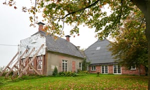
‘Nobody is taking this seriously, not the school or the mayor, no one’ … Annemarie Heite, whose home in Groningen has been scheduled for demolition after earthquakes caused by oil drilling. Photograph: Hans Knikman/Demotix
Lucas Amin
Saturday 10 October 2015 05.00 EDT
Five years ago, Annemarie Heite and her husband, Albert, bought their dream home; a traditional 19th-century farmhouse in Groningen province in the northern Netherlands. The couple planned to raise their two young daughters in this charming corner of the Dutch countryside. “Then, the living was still easy, and affordable,” Annemarie says, her tone bittersweet and nostalgic. Today, their house is scheduled for demolition.
Hundreds of earthquakes have wrecked the foundations of the Heites’ home and made it unsafe to live in. Annemarie’s biggest fear is the safety of her daughters. She points to a room. “This is where my children sleep,” she says, “and everyday I’m just picking up pieces of bricks and stuff from the ceiling.”
Heite fears that her children may not be any safer at school. Her daughter Zara goes to a local primary school that has not been structurally reinforced to withstand strong earthquakes. “I feel powerless. It feels like I can’t do anything,” Heite says. “It’s not like I’m a frantic, hysterical person, but nobody is taking this seriously, not the school or the mayor, no one.”
Next door, Heite’s neighbour’s farmhouse is already a pile of rubble, which yellow JCBs are clearing away. “It’s collapsed. It’s gone,” Heite says. “They lived there for 30 years … and over there behind the trees, they demolished another house.”
Farmhouses like Heite’s are disappearing across the Groningen countryside as a peculiar, profound environmental crisis grips the province. At the heart of it are two oil companies, Shell and Exxon Mobil, and a government that, for two decades, denied responsibility for its actions and ignored the voices of citizens and scientists. The scandal has already cost the oil companies €1.2bn [£880m], but last month a landmark court ruling gave the victims fresh hope that their voices could be ignored no longer. And if they are right, the consequences could be profound: a compensation bill that could stretch to more than €5bn in Holland, an energy security headache for Europe, and an invocation for the world to think about the real cost of burning fossil fuels.
The Hunger Site – Your click helps to feed the hungry
Wheatgrass Kits.com
FAIR USE NOTICE
The material on this site is provided for educational and informational purposes. It may contain copyrighted material the use of which has not always been specifically authorized by the copyright owner. It is being made available in an effort to advance the understanding of scientific, environmental, economic, social justice and human rights issues etc. It is believed that this constitutes a 'fair use' of any such copyrighted material as provided for in section 107 of the US Copyright Law. In accordance with Title 17 U.S.C. Section 107, the material on this site is distributed without profit to those who have an interest in using the included information for research and educational purposes. If you wish to use copyrighted material from this site for purposes of your own that go beyond 'fair use', you must obtain permission from the copyright owner. The information on this site does not constitute legal or technical advice.
Any materials (ie. graphics, articles , commentary) that are original to this blog are copyrighted and signed by it's creator. Said original material may be shared with attribution. Please respect the work that goes into these items and give the creator his/her credit. Just as we share articles , graphics and photos always giving credit to their creators when available. Credit and a link back to the original source is required.
If you have an issue with anything posted here or would prefer we not use it . Please contact me. Any items that are requested to be removed by the copyright owner will be removed immediately. No threats needed or lawsuit required. If there is a problem and you do not wish your work to be showcased then we will happily find an alternative from the many sources readily available from creators who would find it amenable to having their work presented to the subscribers of this feed.
Thank you for your time and attention, blessings to all :)


![[Visit Client Website]](https://gsa.confex.com/img/gsa/banner.jpg)