Category: Drought


Earth Watch Report Banner photo FSPEarthWatchReport900x228Blogger_zps53ef6af0.jpg

……………………………………………………………


Montana Kootenai National Forest Forest Fire 12.11.2015 photo Montana Kootenai National Forest Forest Fire 12.11.2015_zpsqgzgixoy.png

 Montana Kootenai National Forest Forest Fire 12.11.2015

RSOE EDIS

……….

……….

Base data

EDIS Number WF-20151211-51205-USA
Event type Forest / Wild Fire
Date/Time December 11 2015 04:22 AM (UTC)
Last update December 11 2015 04:25 AM (UTC)
Cause of event
Damage level Medium Damage level

Geographic information

Continent North-America
Country United States of America
County / State State of Montana
Area Fort Belknap area
Settlement
Coordinate 48° 28.950,108° 45.926

……….

A large grass fire is burning several miles east of Fort Belknap. There are no reports of injuries at this time; the cause of the fire is not yet known. Randy Perez tells us that the fire is heading toward Pony Hill Cemetery, and is south of Savoy Road. Perez, who lives very close to where the fire is burning, says that it is burning in mostly grass-land, with some alfalfa. He tells us that the wind pushed the fire toward Savoy Road, and the fire then changed direction. Hundreds of tons of hay have burned; at this point, no livestock are believed to have perished. The fire is believed to be about nine miles long, and more than a mile wide. Perez says that ranches have moved two herd of cattle and 100 bulls from the area to escape the approaching flames. At least ten fire trucks are at the scene, with crews responding from the MT Department of Natural Resources and Conservation, Harlem, Turner, Chinook, Dodson, Malta, and Fort Belknap. Authorities estimate that the fire has burned about 5,000 acres.

………..


Fires Continue to Burn on Kootenai National Forest

Fires in Lincoln County continue to burn and send smoke to the Flathead Valley

Unseasonably dry and warm fall weather has allowed the lightning-caused fires in the Goat Rock complex and Marston Fire to continue to burn and send smoke to the Flathead Valley.The fires in the Goat Rock complex have burned more than 22,000 acres and are located in and around the Cabinet Mountains Wilderness and Scotchman Peaks area. The Marston Fire has burned over 7,000 acres north of Trego.

While some of the fires are continuing to grow slowly, the majority of the burning is in the interior with pockets of fuel burning within the perimeter of the fires, fire managers say. These fires will continue to burn and put up smoke until the area receives significant rain and or snow.


Read More Here

………..

Earth Watch Report Banner photo FSPEarthWatchReport900x228Blogger_zps53ef6af0.jpg

………………………………………………………


Eyewitness News

Major increase in weather disasters over last 2 decades

Since 1995, weather disasters have killed millions of people & left billions injured & homeless.

A flood-affected resident swims through floodwaters in Kalay, upper Myanmar’s Sagaing region on August 3, 2015. Relentless monsoon rains have triggered flash floods and landslides, destroying thousands of houses, farmland, bridges and roads with fast-flowing waters hampering relief efforts. Picture: AFP.


GENEVA – Weather-related disasters such as floods and heatwaves have occurred almost daily in the past decade, almost twice as often as two decades ago, with Asia being the hardest hit region, a UN report said on Monday.

While the report authors could not pin the increase wholly on climate change, they did say that the upward trend was likely to continue as extreme weather events increased.

Since 1995, weather disasters have killed millions of people, left billions injured, homeless or in need of aid, and accounted for 90 percent of all disasters, it said.

A recent peak year was 2002, when drought in India hit 200 million and a sandstorm in China affected 100 million.

But the standout mega-disaster was Cyclone Nargis, which killed 138,000 in Myanmar in 2008.


Read More Here

Earth Watch Report Banner photo FSPEarthWatchReport900x228Blogger_zps53ef6af0.jpg          Global Community Report Banner photo FSPLogoGlobalCommunityFulloldworldmapbckgrnd_zps43d3059c.jpg

……………………………………………………………………………………..


VOA Voice of America

California Drought Affects Winter Refuges for Migratory Birds

Sandhill cranes land in flooded fields at the Sandhill Crane Reserve near Thornton, California, Nov. 3, 2015. The state's ongoing drought has left millions of waterfowl that migrate from northern climes to California with fewer places to land, seek food.

Sandhill cranes land in flooded fields at the Sandhill Crane Reserve near Thornton, California, Nov. 3, 2015. The state’s ongoing drought has left millions of waterfowl that migrate from northern climes to California with fewer places to land, seek food.

Reuters

With their red heads, 2.13-meter (7-foot) wingspan and a trilling call, migrating Sandhill Cranes provide a dramatic sunset spectacle as they land by the thousands in wetlands near Sacramento each night during the fall and winter.

But the state’s ongoing drought has left the cranes, along with millions of other waterfowl that migrate from Canada and other northern climes to spend the winter in California, with fewer places to land, threatening their health as they crowd in on one another to seek shelter and food.

“They’re left with fewer and fewer places to go, which will start to have impacts on their population,” said Meghan Hertel, who works on habitat issues for the Audubon Society in California. “They can die here from starvation or disease or be weaker for their flight back north.”

Beloved sight

The cranes are a beloved sight in California’s Sacramento and San Joaquin Valleys when they arrive each fall.

Tourists flock to see them as they take off en masse at dawn or land in a series of swooping, trilling groups as the sun goes down.


Read More Here


Related Articles

Earth Watch Report Banner photo FSPEarthWatchReport900x228Blogger_zps53ef6af0.jpg

……………………………………………………………………………..


Mongabay Environmental News

There have been more than 11,000 fires in just one region of the Brazilian Amazon this year

5th November 2015 / Mike Gaworecki

While climate change can certainly exacerbate drought conditions, leading to more frequent wildfires, this year’s ferocious fire season might also have been heavily influenced by the El Niño event developing in the Pacific Ocean.

  • Satellite images revealed that on October 4, 2015 there were over 900 fires burning in the Brazilian Amazon at once.
  • The region most affected by the fires was the northern state of Amazonas, where some 11,114 forest fires were recorded this year.
  • If the Pacific El Niño continues to strengthen, researchers expect fire risk in the Amazon to increase, as well.
On October 4, 2015, satellite images revealed that there were over 900 fires burning in the Brazilian Amazon.That figure was reported by Brazil’s Institute for Space Research, known as INPE, which said that the region most affected by the fires was the northern state of Amazonas. Some 11,114 forest fires have already been observed in Amazonas this year, a 47 percent increase over the same period last year, according to INPE.

Amazonas is not alone in dealing with increased incidence of forest fires. More than a quarter of the fires so far this year have occurred in the Cerrado agricultural region, which encompasses parts of the central states of Mato Grosso, Mato Grosso do Sul, Tocantins and Minas Gerais, for instance.

Meanwhile, Brazil’s southeastern states have been suffering from extreme drought, and a study by researchers at the Carnegie Institution for Science at Stanford University determined that the area of the Amazon affected by mild to severe drought is likely to double in the eastern part of Amazonia and triple in the west by 2100, due largely to the impacts of deforestation.

The Carnegie Institution researchers did not factor rising global temperatures into their calculations, however, meaning drought conditions are likely to be even worse than they projected. That does not bode well for future fire seasons being tamer than 2015.


Read More Here


………………………………………………………………………………….

the guardian

El Niño: food shortages, floods, disease and droughts set to put millions at risk

Agencies warn of unchartered territory as strongest-ever El Niño threatens to batter vulnerable countries with extreme weather for months

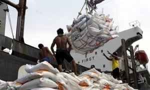
Indonesian workers load rice on a truck at Tanjung Priok Port in Jakarta, Indonesia, on 14 November. Indonesia will import about 1.5m tonnes of rice from Vietnam due to the impact of El Niño.
Indonesian workers load rice on a truck at Tanjung Priok Port in Jakarta, Indonesia, on 14 November. Indonesia will import about 1.5m tonnes of rice from Vietnam due to the impact of El Niño. Photograph: Bagus Indahono/EPA

The UN has warned of months of extreme weather in many of the world’s most vulnerable countries with intense storms, droughts and floods triggered by one of the strongest El Niño weather events recorded in 50 years, which is expected to continue until spring 2016.

El Niño is a natural climatic phenomenon that sees equatorial waters in the eastern Pacific ocean warm every few years. This disrupts regular weather patterns such as monsoons and trade winds, and increases the risk of food shortages, floods, disease and forest fires.

This year, a strong El Niño has been building since March and its effects are already being seen in Ethiopia, Somalia, Kenya, Malawi, Indonesia and across Central America, according to the World Meteorological Organisation. The phenomenon is also being held responsible for uncontrolled fires in forests in Indonesia and in the Amazon rainforest.

The UN’s World Meteorological Organization warned in a report on Monday that the current strong El Niño is expected to strengthen further and peak around the end of the 2015. “Severe droughts and devastating flooding being experienced throughout the tropics and sub-tropical zones bear the hallmarks of this El Niño, which is the strongest in more than 15 years,” said WMO secretary-general Michel Jarraud.

Jarraud said the impact of the naturally occurring El Niño event was being exacerbated by global warming, which had already led to record temperatures this year. “This event is playing out in uncharted territory. Our planet has altered dramatically because of climate change,” he said. “So this El Niño event and human-induced climate change may interact and modify each other in ways which we have never before experienced. El Niño is turning up the heat even further.”


Read More Here

Earth Watch Report Banner photo FSPEarthWatchReport900x228Blogger_zps53ef6af0.jpg

………………………………………………………………………………..


Business Insider

This year’s El Niño is shaping up to be one of the most powerful on record

el ninoNOAA

If you’ve been paying attention to the weather news at all lately, you’ll know that it’s a big year for a weather event called El Niño.

The complex phenomenon could bring warmer, wetter weather to the Northeast this winter and much-needed rain to California, but worsen cold and drought conditions elsewhere in the US.

And this year’s El Niño could be one of the most powerful on record, experts say.

“One of the strongest El Niño events in the past 65 years is likely to bring significant winter weather to the United States,” James Aman, senior meteorologist at Earth Networks, said in a statement.

What the heck is El Niño, anyway?

El Niño is a weather event characterized by warmer-than-normal temperatures in the equatorial Pacific Ocean, with important consequences for global weather and climate, according to the National Oceanic and Atmospheric Administration. By contrast, La Niña refers to colder-than-normal Pacific temperatures.

The effects of El Niño can be seen across the globe, from increased rainfall in the Southern US and Peru to drought in the Western Pacific and brush fires in Australia.


Read More Here

Earth Watch Report Banner photo FSPEarthWatchReport900x228Blogger_zps53ef6af0.jpg

Global Community Report Banner photo FSPLogoGlobalCommunityFulloldworldmapbckgrnd_zps43d3059c.jpg

………………………………………………………………………………..

Queen Mary's Psalter shows men harvesting in 14th century Europe

Climatologists Piece Together a Millennium of Droughts and Downpours

© Photo: Wikimedia commons
Environment
22:00 07.11.2015(updated 22:08 07.11.2015) 

The new Old World Drought Atlas of droughts and wet weather in the Old World gives climate scientists greater perspective on current weather phenomenon.

Climate scientists have produced an atlas reconstructing weather conditions over the last millennium, in an effort to understand more about current changes to the weather.They hope their Old World Drought Atlas (OWDA) will allow for a greater understanding of climate forecasts.

“Climate model projections suggest widespread drying in the Mediterranean Basin and wetting in Fennoscandia in the coming decades largely as a consequence of greenhouse gas forcing of climate,” write the scientists in their paper, published in Science Advances on Friday.

The researchers used archaeological tree ring data to measure more than a thousand years of European weather. They compared their findings to historical accounts of severe droughts, wet weather events or other catastrophes, and found that the tree ring data corresponds with many documented incidents of extreme weather.

……………………………………….

The 700 Year Old Weather Chart That Gives Me Butterflies

Posted by Dan Satterfield

Oh, and look at 1741, and the terrible drought. The trees are showing the results of the cold and dry spell that began in 1739. This is the year of the great Irish famine, and it killed millions as well. Here’s what the paper has to say about the 1741 map:

The Irish famine of 1740–1741: This event has been attributed to unusually low winter and spring temperatures in 1740, resulting in crop failures and subsequent famine (17). The OWDA is not well suited for determining temperature anomalies because it primarily reflects warm season hydroclimate. However, climate field reconstructions of seasonal precipitation from documentary and early instrumental data (18) indicate that spring-summer rainfall over Ireland in 1741 was well below normal relative to the modern average. Drought over Ireland may therefore have contributed to the severity of the famine through its negative impact on food production in 1741. The OWDA map of 1741  indicates severe drought over Ireland that also extended over England and Wales, consistent with previously reported record rainfall deficits.


Fig. 2 OWDA maps of known years of hydroclimatic extremes

Is it just me, or does this give you the willies? It’s like looking at that big high pressure over the NW Atlantic on the night of April 14,1912. The Titanic survivors reported the ocean as still as a mill-pond, and I have the surface weather map that proves they were right. That’s how I feel about these rainfall charts. That horrible famine was seven long centuries ago, but the trees still remember, and they tell us that those old faded pieces of parchment were not exaggerating. It was real, and it left millions dead, and millions more in grief.


This Old World Drought Atlas will have great benefits in climate research, and historians will find them invaluable as well, but they also give us a warning. Our limited 100 years or so of written weather records can be deceiving. We think we know what a bad crop year is, and how long a bad drought can last, but our lifetimes are rather short, and perhaps we are fools. Knowing this makes fooling with our planet’s temperature control even more egregious.

The paper is open access and you can read it all HERE.


Read More Here


Earth Watch Report Banner photo FSPEarthWatchReport900x228Blogger_zps53ef6af0.jpg

………………………………………………………………………………

Discovery News

El Nino May Bring Civil Unrest This Winter

//

When an unusually powerful El Niño struck in 1997, civil conflicts erupted across the tropics, from Sudan to Peru — as floods, droughts and fires devastated crops, fisheries and livelihoods.

It wasn’t an isolated case, suggests growing evidence that links El Niño’s extreme weather with a spike in violent conflicts in tropical regions. As one of the strongest El Niño events in recorded history gains steam this fall, some experts are warning of the potential for more unrest to come – and the urgent need to take preventive action.

Play Video
Some fairly nutty and violent weather can occur during El Nino years.
DCI

“Half the world’s population is exposed to a higher risk of violence this year,” says Solomon Hsiang, professor of public policy at Berkeley. “Now that we know what to expect, we shouldn’t necessarily sit back and watch sparks fly. There are a lot of things we can do.”

Civilizations That Withered in Drought

Collapses of entire civilizations have been linked to climate shifts, with examples that go back centuries. The Little Ice Age in the mid-1600s, for example, has been blamed for widespread wars and political crises that occurred around much of the world at the time.


Read More Here

Earth Watch Report Banner photo FSPEarthWatchReport900x228Blogger_zps53ef6af0.jpg

………………………………………………………………………………

Yahoo News

Associated Press

Associated Press Videos

Raw: Texas Wildfire Covers Six Square Miles

Raw: Texas Wildfire Covers Six Square Miles

AUSTIN, Texas (AP) — The worst of a rural Texas wildfire that has destroyed nearly 50 structures is likely over as firefighters make big strides containing more than 7 miles of scorched and bone-dry forestland, authorities said Friday.

Some residents remain unable to return to their homes on barricaded roads in Bastrop County. But officials said the fire that began Tuesday and grew big enough to waft smoke into downtown Austin, some 40 miles away from the fire, now appears to be getting under control.

“Barring some totally unforeseen circumstance, we’re on the downhill side of this fire,” Bastrop County Judge Paul Pape said.


Read More and Watch Video Here

Global Community Report Banner photo FSPLogoGlobalCommunityFulloldworldmapbckgrnd_zps43d3059c.jpg

Earth Watch Report Banner photo FSPEarthWatchReport900x228Blogger_zps53ef6af0.jpg

………………………………………………………………………………..

the guardian

Environmental groups claim Nestlé is breaking federal law by operating on an expired permit to remove millions of gallons of water from a southern California forest despite the state’s historic drought

A new lawsuit against Nestlé claims the company is illegally pumping millions of gallons of water from California’s San Bernardino National Forest.
A new lawsuit against Nestlé claims the company is illegally pumping millions of gallons of water from California’s San Bernardino National Forest. Photograph: Larry W Smith/EPA

A consortium of environmental advocacy groups filed a lawsuit Tuesday against the US Forest Service, alleging that the federal agency has allowed food and beverage giant Nestlé to illegally pump millions of gallons of water from California’s San Bernardino National Forest for decades, despite the current historic drought.

The Story of Stuff Project, along with co-plaintiffs the Center for Biological Diversity and the Courage Campaign Institute, claim that Nestlé is breaking federal law, operating on a permit expired nearly 20 years ago, in 1988, removing between 50m-150m gallons of water each year from a creek in the southern Californian forest to use in its Arrowhead bottled water brand. The organizations are asking the US Forest Service to immediately turn off the water spigot and conduct a permit review, assessing the environmental impact of Nestlé’s operations.

“They are taking water from a national forest that desperately needs that water,” said Michael O’Heaney, executive director at the Story of Stuff, a group that advocates to clean up consumer culture. “The Forest Service is obligated by law to ensure the natural resources of the forest are protected.”

Lisa Belenky, senior attorney at the Center for Biological Diversity, said the Forest Service “has a duty to look at permits and make sure they’re current and do an environmental review to make sure it isn’t impacting areas of the forest”.

But Nestlé says it isn’t breaking any laws, and insists that its permit hasn’t expired.


Read More Here

WALKER LAKE, Calif.— Thousands of fish are dead after a Northern California reservoir ran dry overnight, reports CBS Sacramento.

Mountain Meadows reservoir also known as Walker Lake is a popular fishing hole just west of Susanville. Now the reservoir is dry and all the fish are dead.

Residents tell CBS Sacramento that people were fishing on the lake just last Saturday. But it drained like a bathtub overnight.


Resident Eddie Bauer has lived near the lake his entire life. He says that this is the first time he has ever seen the lake run dry. He and other residents now want answers as to why and how this could have happened.

CBS Sacramento reports that Pacific Gas & Electric Company own the rights to the water and use it for hydroelectric power.

“It’s the situation we worked hard to avoid but the reality is we’re in a very serious drought, there’s also concerns for the fish downstream,” said spokesman Paul Moreno.


Read More and Watch Video Here