Tag Archive: Extreme Weather in China


Earthquakes


RSOE EDIS


Date/Time (UTC) Magnitude Area Country State/Prov./Gov. Location Risk Source Details
22.07.2012 04:30:35 3.4 North America United States Alaska Clam Gulch There are volcano(s) nearby the epicenter. VulkĂĄn 0 VulkĂĄn 0 USGS-RSOE Details
22.07.2012 03:20:21 3.9 South-America Argentina Salta San Antonio de los Cobres There are volcano(s) nearby the epicenter. VulkĂĄn 0 VulkĂĄn 0 EMSC Details
22.07.2012 03:20:45 4.7 Pacific Ocean – East Tonga Tongatapu Havelu VulkĂĄn 0 VulkĂĄn 0 VulkĂĄn 0 EMSC Details
22.07.2012 02:25:27 4.7 Pacific Ocean Tonga Tongatapu Havelu VulkĂĄn 0 VulkĂĄn 0 VulkĂĄn 0 USGS-RSOE Details
22.07.2012 01:30:40 2.0 North America United States Nevada Topaz Lake There are volcano(s) nearby the epicenter. VulkĂĄn 0 VulkĂĄn 0 USGS-RSOE Details
22.07.2012 01:16:31 2.7 North America United States Alaska Salcha VulkĂĄn 0 VulkĂĄn 0 VulkĂĄn 0 USGS-RSOE Details
22.07.2012 01:31:05 3.1 Caribbean British Virgin Islands Road Town VulkĂĄn 0 There are airport(s) nearby the epicenter. VulkĂĄn 0 USGS-RSOE Details
22.07.2012 01:15:20 4.2 Europe Russia Kuril’sk There are volcano(s) nearby the epicenter. VulkĂĄn 0 VulkĂĄn 0 EMSC Details
22.07.2012 00:56:05 4.2 Asia Russia Kuril’sk There are volcano(s) nearby the epicenter. VulkĂĄn 0 VulkĂĄn 0 USGS-RSOE Details
22.07.2012 01:15:46 2.5 Asia Turkey Denizli Kale VulkĂĄn 0 There are airport(s) nearby the epicenter. VulkĂĄn 0 EMSC Details
22.07.2012 01:16:07 2.9 South-America Chile Antofagasta Calama There are volcano(s) nearby the epicenter. There are airport(s) nearby the epicenter. VulkĂĄn 0 EMSC Details
21.07.2012 23:30:29 2.7 North America United States Alaska Susitna VulkĂĄn 0 VulkĂĄn 0 VulkĂĄn 0 USGS-RSOE Details
22.07.2012 01:20:39 3.2 Pacific Ocean New Zealand Canterbury Tai Tapu VulkĂĄn 0 There are airport(s) nearby the epicenter. VulkĂĄn 0 GEONET Details
22.07.2012 00:10:22 2.0 Europe Italy Umbria Monte Grimano VulkĂĄn 0 There are airport(s) nearby the epicenter. VulkĂĄn 0 EMSC Details
22.07.2012 00:10:43 4.8 Pacific Ocean – East Tonga Vava`u Hihifo There are volcano(s) nearby the epicenter. VulkĂĄn 0 VulkĂĄn 0 EMSC Details
21.07.2012 23:20:22 4.9 Pacific Ocean Tonga Vava`u Hihifo There are volcano(s) nearby the epicenter. VulkĂĄn 0 VulkĂĄn 0 USGS-RSOE Details
21.07.2012 23:10:23 4.2 Europe Greece South Aegean Kamarion There are volcano(s) nearby the epicenter. There are airport(s) nearby the epicenter. VulkĂĄn 0 EMSC Details
21.07.2012 23:10:54 2.8 Europe Italy Emilia-Romagna San Prospero VulkĂĄn 0 There are airport(s) nearby the epicenter. VulkĂĄn 0 EMSC Details
21.07.2012 23:11:18 3.1 Europe Poland Lower Silesian Voivodeship Sieroszowice VulkĂĄn 0 There are airport(s) nearby the epicenter. VulkĂĄn 0 EMSC Details
21.07.2012 21:45:39 3.0 North America United States Alaska Old Harbor VulkĂĄn 0 VulkĂĄn 0 VulkĂĄn 0 USGS-RSOE Details
21.07.2012 22:05:26 3.5 South-America Chile Antofagasta Tocopilla VulkĂĄn 0 There are airport(s) nearby the epicenter. VulkĂĄn 0 EMSC Details
22.07.2012 02:20:27 3.0 Middle-East Lebanon Nabatîyé Habbouch VulkĂĄn 0 There are airport(s) nearby the epicenter. VulkĂĄn 0 EMSC Details
22.07.2012 00:11:14 3.1 Caribbean Dominican Republic La Altagracia Boca de Yuma VulkĂĄn 0 There are airport(s) nearby the epicenter. VulkĂĄn 0 USGS-RSOE Details
21.07.2012 22:05:47 2.1 Asia Turkey Amasya Dedekoy VulkĂĄn 0 There are airport(s) nearby the epicenter. VulkĂĄn 0 EMSC Details
21.07.2012 22:06:07 2.9 Asia Turkey Mu?la OEluedeniz VulkĂĄn 0 There are airport(s) nearby the epicenter. VulkĂĄn 0 EMSC Details
21.07.2012 20:15:57 2.3 North America United States Alaska Ruby VulkĂĄn 0 VulkĂĄn 0 VulkĂĄn 0 USGS-RSOE Details
21.07.2012 22:06:30 4.6 Indonesian Archipelago Indonesia East Nusa Tenggara Kisba Dua There are volcano(s) nearby the epicenter. VulkĂĄn 0 VulkĂĄn 0 EMSC Details
21.07.2012 20:00:22 2.6 Europe Greece Peloponnese Areopolis VulkĂĄn 0 There are airport(s) nearby the epicenter. VulkĂĄn 0 EMSC Details
21.07.2012 20:00:58 2.3 Asia Turkey Konya Kuyulusebil VulkĂĄn 0 VulkĂĄn 0 VulkĂĄn 0 EMSC Details
21.07.2012 19:45:30 2.4 North America United States Alaska Seward VulkĂĄn 0 VulkĂĄn 0 VulkĂĄn 0 USGS-RSOE Details
21.07.2012 19:30:35 2.0 North America United States California Coalinga VulkĂĄn 0 There are airport(s) nearby the epicenter. VulkĂĄn 0 USGS-RSOE Details
21.07.2012 20:01:23 3.2 Middle-East Lebanon Nabatîyé Habbouch VulkĂĄn 0 There are airport(s) nearby the epicenter. VulkĂĄn 0 EMSC Details
21.07.2012 20:01:48 2.7 Europe Greece Epirus Samonida VulkĂĄn 0 There are airport(s) nearby the epicenter. VulkĂĄn 0 EMSC Details
21.07.2012 22:06:52 4.5 Indonesian Archipelago Indonesia East Nusa Tenggara Kisba Dua There are volcano(s) nearby the epicenter. VulkĂĄn 0 VulkĂĄn 0 EMSC Details
21.07.2012 19:30:59 3.4 Caribbean Puerto Rico Hatillo Hatillo VulkĂĄn 0 VulkĂĄn 0 VulkĂĄn 0 USGS-RSOE Details
21.07.2012 22:07:15 4.6 Indian Ocean Maldives Kudahuvadhoo VulkĂĄn 0 VulkĂĄn 0 VulkĂĄn 0 EMSC Details
21.07.2012 20:02:17 2.9 South-America Chile Valparaíso La Ligua VulkĂĄn 0 There are airport(s) nearby the epicenter. VulkĂĄn 0 EMSC Details
21.07.2012 18:30:37 2.1 North America United States California Descanso VulkĂĄn 0 There are airport(s) nearby the epicenter. VulkĂĄn 0 USGS-RSOE Details
21.07.2012 18:56:11 4.6 Indonesian Archipelago Indonesia East Nusa Tenggara Kisba Dua There are volcano(s) nearby the epicenter. VulkĂĄn 0 VulkĂĄn 0 EMSC Details
21.07.2012 18:21:04 4.6 Indonesian archipelago Indonesia East Nusa Tenggara Kisba Dua There are volcano(s) nearby the epicenter. VulkĂĄn 0 VulkĂĄn 0 USGS-RSOE Details
21.07.2012 18:56:43 3.4 Middle-East Iraq Arb?l Rawanduz VulkĂĄn 0 VulkĂĄn 0 VulkĂĄn 0 EMSC Details
21.07.2012 18:57:07 2.5 Asia Turkey Antalya Buyukbelkis VulkĂĄn 0 VulkĂĄn 0 VulkĂĄn 0 EMSC Details
21.07.2012 17:50:50 2.4 North America United States California Markleeville VulkĂĄn 0 VulkĂĄn 0 VulkĂĄn 0 USGS-RSOE Details
21.07.2012 17:55:19 2.8 Europe Greece Attica Agia Pelagia VulkĂĄn 0 There are airport(s) nearby the epicenter. VulkĂĄn 0 EMSC Details
21.07.2012 17:55:43 2.5 Asia Turkey Mu?la Kargi VulkĂĄn 0 There are airport(s) nearby the epicenter. VulkĂĄn 0 EMSC Details
21.07.2012 17:56:11 2.3 Asia Turkey Mu?la OEluedeniz VulkĂĄn 0 There are airport(s) nearby the epicenter. VulkĂĄn 0 EMSC Details
21.07.2012 17:56:35 2.5 Asia Turkey Mu?la Yatagan VulkĂĄn 0 There are airport(s) nearby the epicenter. VulkĂĄn 0 EMSC Details
21.07.2012 16:55:19 2.5 Asia Turkey Mu?la OEluedeniz VulkĂĄn 0 There are airport(s) nearby the epicenter. VulkĂĄn 0 EMSC Details
21.07.2012 16:00:30 3.2 Middle America Mexico Baja California Alberto Oviedo Mota There are volcano(s) nearby the epicenter. There are airport(s) nearby the epicenter. VulkĂĄn 0 USGS-RSOE Details
21.07.2012 15:50:27 3.7 South-America Chile Antofagasta Tocopilla VulkĂĄn 0 There are airport(s) nearby the epicenter. VulkĂĄn 0 EMSC Details

**********************************************************************************************************

Volcanic Activity

New Zealand : Tongariro volcano alert at new high

By Matthew Backhouse and Kieran Campbell

An aerial view over the Tongariro National Park. Photo / Greg Bowker

Expand

An aerial view over the Tongariro National Park. Photo / Greg Bowker

A “sudden rise” in volcanic activity at Mt Tongariro has prompted scientists to lift its volcanic alert status for the first time.

But local businesses and conservation authorities remain unconcerned as they seek to reassure visitors it is “business as usual” at National Park.

GNS Science this afternoon lifted Mt Tongariro’s volcanic alert status from level zero to level one, and increased the aviation status from green to yellow.

It said a series of more than 20 “small” volcanic earthquakes had been recorded at Tongariro since July 13 – more than the average of two per year according to historic seismic data.

The quakes, below a magnitude of 2.5 and between 2-7km deep, were recorded in a cluster zone between Emerald Crater and Te Maari craters.

The sequence of earthquakes soon declined but restarted on Wednesday and increased in number yesterday and today.

GNS volcanologist Brad Scott said it was the first time the alert level had been lifted at Tongariro since the alert system was introduced.

“It’s displaying some form of unrest. We don’t know exactly what’s driving it, if we did we’d be saying.”

To get a clearer picture, GNS would deploy portable seismic recorders around the epicentres of the earthquakes and conduct sampling of selected hot springs, crater lakes and fumaroles in the area.

“We’ve got our permanent networks out giving us data in real time… (and) we want to compliment that with some more data, just to add to our knowledge.”

Mt Tongariro is a volcanic complex that lies to the north of Ngauruhoe and consists of numerous craters and vents.

There are six alert levels of volcanic action, increasing in seriousness from zero to five. Alert level one indicates “signs of volcano unrest”.

For the alert level to be lifted to two – “minor eruptive activity” – there would need to be an eruption and there was no indication that would happen.

The aviation status yellow also acts as a warning of increased unrest.

Department of Conservation local conservation analyst Harry Keys said GNS Science was dealing with the matter and the department did not need to take any action at this stage.

The popular Tongariro Alpine Crossing passed close to Te Maari craters, where the most recent ash eruptions took place from 1855 to 1897.

But there was no hazard at the moment and the crossing would remain open to the public.

“There are public safety matters if the volcano starts getting active, but at the moment the volcano is not getting active and it may not ever get active,” he said.

“We’ve got everything ready if we have to do anything. We will then go to the next stage, but at the moment we’re not doing anything.”

Dr Keys said he would not expect more or fewer visitors at the moment.

“It’s definitely business as usual. People might make their own decisions, but there’s no reason at the moment they should make any decisions about what they’ve planned.”

National Park Business Association chairman Murray Wilson said the only problem with volcanic activity was when it interrupted visitor flows.

He had been at a regional tourism meeting today but the issue was not even raised.

“It’s just a fact of life around here and I don’t think anyone around the place will be to excited about that – it’s probably more of a technical response than a physical response.”

Mr Wilson said “media hype” had been the biggest issue the last time neighbouring Ruapehu had erupted in the 1990s.

“The people around here depend on uninterrupted visitor flows. Last year we had interrupted visitor flows because of the Rugby World Cup – as soon as the rugby started, people tended to stay at home and go to the rugby matches.”

He did not think there would be much impact unless it was “over-reported and people get worried”.

APNZ

By Matthew Backhouse and Kieran Campbell | Email Matthew

Strong quake hits off east coast of New Zealand

  AP


WELLINGTON, New Zealand — A strong earthquake has struck off the east coast of New Zealand, but there were no immediate reports of any injuries or damage.

The U.S. Geological Survey says the magnitude-5.8 temblor struck Saturday off the east coast of the North Island at a depth of 20 kilometers (12 miles).

New Zealand is prone to earthquakes. In February 2011, a strong quake in Christchurch killed 185 people and destroyed much of the city’s downtown area.

X-rays illuminate the origin of volcanic hotspots

by Staff Writers
Paris, France (SPX)

SHAKE AND BLOW

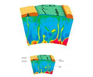
This is an illustration showing how the mantle plumes can be emitted from the core-mantle boundary region to reach the Earth’s crust. Due to the lateral displacement of the tectonic plates at the surface, the mantle plumes can create a series of aligned hot spot volcanoes. A mid ocean ridge and a subducted plate are also shown. Credit: ESRF/Denis Andrault/Henri Samuel. For a larger version of this image please go here.

Scientists have recreated the extreme conditions at the boundary between Earth’s core and its mantle, 2,900 km beneath the surface. Using the world’s most brilliant beam of X-rays, they probed speck-sized samples of rock at very high temperature and pressure to show for the first time that partially molten rock under these conditions is buoyant and should segregate towards the Earth’s surface.

This observation is a strong evidence for the theory that volcanic hotspots like the Hawaiian Islands originate from mantle plumes generated at the Earth’s core-mantle boundary. The results are published in Nature dated 19 July 2012.

The group of scientists was led by Denis Andrault from the Laboratoire Magmas et Volcans of University Blaise Pascal in Clermont, and included scientists from the CNRS in Clermont and the European Synchrotron Radiation Facility (ESRF) in Grenoble, France.

Most volcanoes are situated where continental plates are pushed or pulled against each other. Here, the continental crust is weakened, and the magma can break through to the surface. The Pacific “Ring of Fire”, for example, exhibits such plate movements, resulting in powerful Earthquakes and numerous active volcanoes.

Volcanic hotspots are of a completely different nature because most of them are far away from plate boundaries. The Hawaiian Islands, for example, are a chain of volcanoes thought to have their origin in a mysterious hot spot beneath the Pacific ocean floor. Every island in the chain starts as an active volcano fed by the hot spot that eventually rises above the ocean surface. As plate tectonics move the volcano away from the hotspot, it becomes extinct.

The hot spot will in the meantime create another volcano: the next island in the chain. The Hawaiian Islands are one of many examples of this process, like the Canary Islands, La Reunion or the Azores.

The nature of the hot-spot source and its location in the mantle have remained elusive to the present day. One explanation is narrow streams of magma conveyed to the Earth’s surface from the boundary between the Earth’s core of liquid iron and the solid mantle of silicate rock. Whether the lowermost mantle expels such streams of magma called mantle plumes is one of today’s major controversies among geologists.

What material can be stored at the core-mantle boundary and become sufficiently light to rise through 2900 km of thick solid mantle? This was the question Denis Andrault and his colleagues addressed when they set out to recreate in a laboratory the conditions found at the core-mantle boundary.

They compressed tiny pieces of rock, the size of a speck of dust and ten times thinner than a human hair, between the tips of two conical diamonds to a pressure of more than one million bar. A laser beam then heated these samples to temperatures between 3000 and 4000 degrees Celsius, which scientists believe is representative of the 200km-thick core-mantle boundary. The samples are extremely small compared to the natural processes occurring in the Earth.

However, the melting processes are very well reproduced experimentally. Therefore, the observations can be confidently transferred from micron scale in the experiments to kilometre scale in the deep mantle.

Beams of X-rays at the ESRF, focused to a diameter of one 1000th of a millimetre, were used to map these samples and identify where the solid rock had melted. “Obviously, these tiny samples produce weak interaction signals, and this is why it is important to have the most brilliant X-ray beams for this type of experiments, says Mohammed Mezouar, the scientist responsible for the high-pressure beamline ID27 at the ESRF.

Once regions with molten rock had been identified, another X-ray technique was used at the ESRF to compare the chemical compositions of previously molten and solid parts. “It is the iron content which is decisive for the density of molten rock at the core-mantle boundary. Its accurate knowledge allowed us to determine that molten rock under these conditions is actually lighter than solid,” says Denis Andrault.

Gravity makes the light liquid rock from a hotspot move slowly upwards like a bubble in water until it reaches the surface where the magma plume will form a volcano. The hotspots of liquid occur in the relatively thin boundary region between the solid lower mantle and the liquid outer core of the Earth where the temperature rises over a distance of just 200 kilometres from 3000 to 4000 degrees. This steep rise is caused by the vicinity of the much hotter core and induces a partial melting of the rocks.

The results of the experiment are also of great significance for the understanding of the early history of the Earth, as they provide an explanation why many chemical elements playing a key role in our daily life gradually accumulated from the Earth’s inside to its thin crust, close to the surface.

“We know less about the Earth’s mantle than about the surface of Mars. It is impossible to drill a hole of even 100 kilometres into the Earth, so we have to recreate it in the laboratory. This is important knowledge, because active hot spot volcanoes like those in Iceland can be dangerous and disruptive for the daily lives of people far away”, concludes Denis Andrault.

Related Links
European Synchrotron Radiation Facility
Bringing Order To A World Of Disasters
When the Earth Quakes
A world of storm and tempest

***********************************************************************************************************

Extreme Temperatures/ Weather / Drought


Excessive Heat Warning


KANSAS CITY/PLEASANT HILL MO
OMAHA/VALLEY NE
DES MOINES IA
HASTINGS NE
TOPEKA KS
ST LOUIS MO
PADUCAH KY


Heat Advisory


FORT WORTH TX
OMAHA/VALLEY NE
HASTINGS NE
MEMPHIS TN
SPRINGFIELD MO
NORMAN OK
TULSA OK
GOODLAND KS
SIOUX FALLS SD
NORTH PLATTE NE
WICHITA KS
ST LOUIS MO


Red Flag Warning

FIRE WEATHER MESSAGE


MEDFORD OR
BOISE ID
POCATELLO ID


Fire Weather Watch


BOISE ID


21.07.2012 Extreme Weather China Capital City, Beijing Damage level
Details


Extreme Weather in China on Saturday, 21 July, 2012 at 17:59 (05:59 PM) UTC.

Description
At least 12 people died during torrential rainstorms which battered much of northern and southwestern China from Friday night to Saturday, state media reported. In Beijing, strong winds blew off rooftops killing two people and injuring six others, the Beijing Emergency Medical Center reported. Heavy rain flooded roads and caused 223 flights to be cancelled in the capital, as the Beijing Meteorological Bureau issued its second-highest rainstorm alert for the first time since 2005. The report said Beijing received 95 mm of precipitation on average as of 7:00 pm (1100 GMT), and heavy rainfall is expected to last until Sunday morning.


20.07.2012 Forest / Wild Fire Portugal Atlantic Ocean – North, [Island of Madeira ] Damage level
Details


Forest / Wild Fire in Portugal on Thursday, 19 July, 2012 at 19:09 (07:09 PM) UTC.

Back

Updated: Friday, 20 July, 2012 at 02:51 UTC
Description
The Interior Ministry sent a military transport plane with 83 firefighters to Madeira, where the flames briefly threatened the outskirts of the region’s capital and popular tourist destination Funchal on Wednesday night. Interior Minister Miguel Macedo also flew to Madeira to coordinate the efforts.


21.07.2012 Forest / Wild Fire USA State of Missouri, [Near to Ash Grove] Damage level
Details


Forest / Wild Fire in USA on Friday, 20 July, 2012 at 18:11 (06:11 PM) UTC.

Description
Firefighters from several departments started fighting a fast-spreading brush fire east of Ash Grove near U.S. 160 at Farm Road 43. Firefighters were dispatched at about 9 a.m. to fight a brush fire that was originally reported to be two acres in size. Crews from Everton, Bois D’Arc, Willard, Ash Grove and Walnut Grove worked to prevent the fire from spreading to a field with a machine shed in it. The fire spread to the outer edge of U.S. 160 close to at least one home. It wasn’t the peace and quiet for sleeping Stan Pyle planned on. “I work night shift at French’s, and I actually got home and got to bed. My wife just woke me up and said there’s a fire across the street, and my son and I hook up all the garden hoses we had,” Pyle says. Ash Grove and Walnut Grove firefighters were the first on the scene. “We had approximately two acres when we first got here, but the winds pushed it pretty fast on us,” says Ash Grove Fire Chief Anthony Monnig.


21.07.2012 Forest / Wild Fire USA State of Washington, [Near to Horseshoe Bend] Damage level
Details


Forest / Wild Fire in USA on Friday, 20 July, 2012 at 11:03 (11:03 AM) UTC.

Description
Firefighters contained a brush fire that threatened homes south of Horseshoe Bend Thursday afternoon. Officials tell us that about 10 to 20 homes on Horseshoe Bend Hill were evacuated. A spokesperson for the Bureau of Land Management said a lot of resources were put on the Summit Fire to keep it from spreading and destroying homes. Fire departments from Horseshoe Bend, Eagle and the BLM responded. Six fire engines, five structure protection units, two water tenders, one bulldozer, two helicopters and one plane were called to the scene. Windy conditions and dry brush fueled the fire, which burned around 100 acres. One outbuilding was lost in the fire. The fire was reported around 2:20 p.m. “When you do get a grass fire that burns hot and fast, those homes are usually in the direct path of that,” said Nevil Humphreys of the Eagle Fire Department. The fire burned to within about a quarter-mile of Highway 55, but the road remained open to traffic. Boise County Sheriff’s deputies went door-to-door urging residents near the fire to evacuate their homes.

The Kreitzer family lives in one of the homes that was evacuated. They were all out of the house when the fire started. Ingrid Kreitzer said their neighbor alerted them to the fire. “He called and he said, ‘You know, I think you probably should come up. It looks like it might be coming closer. You might just want to come down and hose anything in case it jumps over,'” Kreitzer said. She said with all the recent fires, her family had been creating a fire plan in case of the wildfire. Crews on the scene told us homes they saw had good defensible space, helping to keep them safe. “We were able to get in there, limb up some brush and what not,” said Paul Story, a firefighter who came in with his crew from Salt Lake to help with recent fires. “It was very minimal effort on our part, and so the homeowner did a good job in that regard.” Humphreys said the fire is human-caused and remains under investigation. No homes were destroyed in the fire.


Worst drought in five decades ravages US

by Staff Writers
Washington (AFP)

Weather forecasters see no end in sight to the worst US drought in five decades, a blistering heatwave that has wilted crops across America’s crucial breadbasket and sent grain prices soaring.

Farmers are mulling cutting down crops and thinning livestock herds as meteorologists said the country’s central breadbasket, the world’s largest source of both soybeans and corn, faces another month of stifling, rainless heat.

Top US agriculture official Tom Vilsack announced Wednesday he was designating 39 more counties in eight states as “natural disaster areas,” making farmers there eligible for low-cost emergency loans. Nearly 1,300 counties across 29 states have been designated natural disaster areas this year.

Vilsack also met with President Barack Obama Wednesday to review options to deal with the drought.

Meanwhile, a World Bank official said they were watching to see how the drought could impact global food supplies, after sharp surges in food prices in 2008 and 2010 dealt harsh blows to poor, food-importing nations.

“While it’s too early to be overly concerned, the Bank is monitoring the situation closely for potential impacts on our clients,” said Marc Sadler, team leader for the World Bank’s Agricultural Finance and Risk Management Unit.

“Global stocks in most of the tradable grains are lower now than they have been historically… we don’t have as much in the larder as we used to.”

More than 60 percent of the continental United States has been under drought and extreme heat conditions since June, according to Mark Svoboda of the National Drought Mitigation Center in Lincoln, Nebraska.

Temperatures have topped 100 degrees Fahrenheit (38 Celsius) for days in a row in many places, with the central plains running three to four degrees Fahrenheit above normal this month.

Svoboda said the drought was as tough as the worst in the 1930s and 1950s, although those benchmarks were multi-season, multi-year disasters while the current situation only dates to May.

But, he pointed out, the timing of the lack of rain and the heat has been particularly devastating, coming just at the peak of the growing season with the epicenter the central US farm belt east of the Rocky Mountains all the way to the Atlantic coast.

It has hit corn, soybeans, and crops like hay needed to feed cattle especially hard.

Farmers are now looking at cutting their losses — chopping down fields of half-mature, ear-less corn to feed the stalks to cattle.

“The jury is still a little bit out on it. We are in that process right now, making that decision,” said Steve Foglesong, who raises cattle and farms corn in Astoria, Illinois.

“From the road the corn looks green, but there are no ears on it.”

Foglesong said the next two weeks will be crucial, but weather forecasters were not encouraging.

“The worst of the drought is right in the middle of the nation, the corn belt. It’s just been bone dry,” said Carl Erickson, a meteorologist at Accuweather.

“Unfortunately across the central plains, the Mississippi valley, it looks like the overall pattern will remain in place for the rest of the month and into August,” he said.

“Once you get into a pattern like this, it almost feeds on itself.”

Joseph Glauber, chief economist for the Department of Agriculture, said their surveys show that 38 percent of the corn crop, and 30 percent of the soybean crop, are considered in “poor” or “extremely poor” condition.

That compares to 9 percent and 8 percent respectively this time last year.

In the last big drought, in 1988, corn yields fell by more than 20 percent, Glauber noted. Although the department will wait until early August before reaching a conclusion about the crops, he said: “It’s evolving as we speak. Every week these crop conditions have gotten worse.”

Corn prices have soared by 50 percent since May, while the rate for soybeans, which develop later than corn and might be able to bear up under another few weeks of rainless conditions, has surged 26 percent.

Ironically, in a way, beef and other meat prices have fallen. Glauber said some ranchers facing higher feed prices appear to be reducing their herds, pushing livestock into the market.

Foglesong said that in addition, from what he can tell the heat wave has been so intense around so much of the country that consumers have curtailed their summer barbecues, also hitting demand for steaks, ribs and other products.

Over the longer term, Glauber said, the herd reductions will mean tighter supplies and higher prices for meat on top of the grains.

Svoboda said that the crops aren’t the only problem. The drought has already fed devastating wildfires in the west, and if it keeps on, he predicts cities will start running into limits on their water supplies, which could lead to water use controls.

Related Links
Climate Science News – Modeling, Mitigation Adaptation

***********************************************************************************************************

Storms / Flooding / Landslides


Active tropical storm system(s)
Name of storm system Location Formed Last update Last category Course Wind Speed Gust Wave Source Details
09W Pacific Ocean 21.07.2012 21.07.2012 Tropical Depression 265 ° 56 km/h 74 km/h 4.57 m JTWC Details


 Tropical Storm data

Share:
Storm name: Vicente (09W)
Area: Pacific Ocean
Start up location: N 19° 30.000, E 116° 36.000
Start up: 21st July 2012
Status: 01st January 1970
Track long: 71.98 km
Top category.:
Report by: JTWC
Useful links:

Past track
Date Time Position Speed
km/h
Wind
km/h
Gust
km/h
Category Course Wave Pressure Source
Current position
Date Time Position Speed
km/h
Wind
km/h
Gust
km/h
Category Course Wave
feet
Pressure Source
22nd Jul 2012 05:07:48 N 19° 24.000, E 115° 30.000 19 83 102 Tropical Storm 290 ° 10 JTWC
Forecast track
Date Time Position Category Wind
km/h
Gust
km/h
Source
23rd Jul 2012 12:00:00 N 20° 42.000, E 110° 30.000 Tropical Storm 93 120 JTWC
23rd Jul 2012 00:00:00 N 20° 30.000, E 112° 0.000 Tropical Storm 83 102 JTWC
24th Jul 2012 12:00:00 N 20° 54.000, E 108° 6.000 Tropical Storm 93 120 JTWC
25th Jul 2012 12:00:00 N 21° 24.000, E 106° 6.000 Tropical Storm 65 83 JTWC
26th Jul 2012 12:00:00 N 22° 6.000, E 104° 12.000 Tropical Depression 37 56 JTWC


21.07.2012 Tropical Storm North Korea MultiProvinces, [Provinces of Kangwon, North Gyeongsang and South Hwanghae] Damage level
Details


Tropical Storm in North Korea on Saturday, 21 July, 2012 at 03:31 (03:31 AM) UTC.

Description
Tropical storm Khanun destroyed scores of houses, buildings and transportation infrastructure in southern parts of North Korea this week, killing at least seven people in the reclusive state, state-run media reported on Friday. It weakened quickly over North Korea before Khanun’s remnants dissipated over China. The state-run Korean Central News Agency (KCNA) reported on Friday that flooding triggered by Khanun caused significant damage and casualties in the southern regions of North Korea. It said at least seven people were killed in Kangwon Province, but few other details about casualties were released. “Many hectares of farmland were inundated in Kangwon province and some dwelling houses, public buildings, railways, roads, bridges, breakwaters, electric supply and communication networks were destroyed,” KCNA said in its report, adding that some areas saw up to 200 millimeters (7.8 inches) of rain. “The water supply system was paralyzed in Wonsan and Munchon cities, suspending the provision of drinking water to citizens.” In South Hwanghae province, several houses were destroyed in Haeju City and Jaeryong County while large areas of cropland were submerged in Unchon County. The report did not say whether there were casualties in South Hwanghae province, or in any other regions of North Korea. In South Korea, Khanun also caused flooding, power outages, and affected major transportation systems. One fatality was reported in North Gyeongsang province when the wall of a home collapsed, officials said.


21.07.2012 Flash Flood USA State of North Carolina, Charlotte Damage level
Details


Flash Flood in USA on Saturday, 21 July, 2012 at 03:20 (03:20 AM) UTC.

Description
A North Carolina mall was evacuated Friday when a thunderstorm that produced heavy rain caused the ceiling to collapse, officials said. The ceiling at SouthPark collapsed around 5 p.m., said Charlotte Fire Department Capt. Rob Brisley. He said by the time firefighters were dispatched to the mall, an evacuation was already under way. Brisley said firefighters also pulled the alarm systems in the mall to help with the evacuation, which he described as orderly. No injuries were reported. Brisley said firefighters were focusing on making sure the building was safe, and that the water damage could be addressed by mall workers. Mall personnel couldn’t be reached for additional comment Friday afternoon. It’s estimated that up to 3 inches of rain fell on south Charlotte in approximately 45 minutes, said Rodney Hinson, a meteorologist at the National Weather Service office in Greer, S.C. Hinson said additional rain was likely to pass over Charlotte Friday night.


Flood Warning


LAKE CHARLES LA
TAMPA BAY AREA - RUSKIN FL


21.07.2012 Landslide Austria Province of Styria, Thoerl Damage level
Details


Landslide in Austria on Saturday, 21 July, 2012 at 16:54 (04:54 PM) UTC.

Description
Mudslides unleashed by torrential rains killed one man, wrecked houses and cut off villages in the Austrian province of Styria, authorities said on Saturday. Police in the southeastern province said they had found the body of a 47-year-old local man swept away by a mudslide on Friday night in the town of Thoerl. Several small communities near Liezen were stranded by blocked roads. Austrian broadcaster ORF said helicopters evacuated around 20 people from the area after mudslides up to 10 meters (30 feet) high made travel by road impossible. A further 360 people had to leave their homes in the town of Sankt Lorenzen for fear of more slides given unrelenting rainfall, authorities said.


****************************************************************************************

Epidemic Hazards / Diseases


20.07.2012 Epidemic Sierra Leone Eastern Province, [Kenema District] Damage level
Details


Epidemic in Sierra Leone on Friday, 20 July, 2012 at 18:17 (06:17 PM) UTC.

Description
Director of Disease Prevention and Control at the Ministry of Health and Sanitation, Dr. Amara Jambai, has yesterday disclosed that the outbreak of Lassa fever in Kenema district. Lassa fever is a viral disease which is carried by rats. It is spread from infected rodents to humans through direct contact with urine and droppings of an infected rat. Speaking to journalists at the weekly press briefing at the Ministry of Information and Communications, Dr. Jambai said the outbreak, which started in three districts but has extended to other parts of the country, should be a serious concern to the government and people of Sierra Leone.
Biohazard name: Lassa Fever Outbreak
Biohazard level: 4/4 Hazardous
Biohazard desc.: Viruses and bacteria that cause severe to fatal disease in humans, and for which vaccines or other treatments are not available, such as Bolivian and Argentine hemorrhagic fevers, H5N1(bird flu), Dengue hemorrhagic fever, Marburg virus, Ebola virus, hantaviruses, Lassa fever, Crimean-Congo hemorrhagic fever, and other hemorrhagic or unidentified diseases. When dealing with biological hazards at this level the use of a Hazmat suit and a self-contained oxygen supply is mandatory. The entrance and exit of a Level Four biolab will contain multiple showers, a vacuum room, an ultraviolet light room, autonomous detection system, and other safety precautions designed to destroy all traces of the biohazard. Multiple airlocks are employed and are electronically secured to prevent both doors opening at the same time. All air and water service going to and coming from a Biosafety Level 4 (P4) lab will undergo similar decontamination procedures to eliminate the possibility of an accidental release.
Symptoms:
Status: confirmed


21.07.2012 Epidemic Sierra Leone Northern Province, [Port Loko, Kambia, Pujehun and Kailahun districts] Damage level
Details


Epidemic in Sierra Leone on Friday, 20 July, 2012 at 18:20 (06:20 PM) UTC.

Description
Director of Disease Prevention and Control at the Ministry of Health and Sanitation, Dr. Amara Jambai, has yesterday disclosed that the outbreak of cholera in Port Loko, Kambia, Pujehun and Kailahun districts and the Western Area has claimed 62 lives so far. Speaking to journalists at the weekly press briefing at the Ministry of Information and Communications, Dr. Jambai said the outbreak, which started in three districts but has extended to other parts of the country, should be a serious concern to the government and people of Sierra Leone. Dr. Jambai explained adding that 26 cholera deaths have been reported in Kambia, 22 in Port Loko, nine in Pujehun and another nine in the Western Area which sum up to 62 cholera cases reported since January to date. “We have set up cholera treatment units at Macaulay Street and Connaught hospital with three more to follow. Also, we have provided technical assistance, drugs and rapid diagnostic test kits at various locations across the country,” he added to highlight measures his department has put in place to curtail the situation. He however warned that despite efforts by the health ministry to cub the outburst, people should be more careful about their food and water sources and should endeavour to always keep their environment clean.
Biohazard name: Cholera Outbreak
Biohazard level: 2/4 Medium
Biohazard desc.: Bacteria and viruses that cause only mild disease to humans, or are difficult to contract via aerosol in a lab setting, such as hepatitis A, B, and C, influenza A, Lyme disease, salmonella, mumps, measles, scrapie, dengue fever, and HIV. “Routine diagnostic work with clinical specimens can be done safely at Biosafety Level 2, using Biosafety Level 2 practices and procedures. Research work (including co-cultivation, virus replication studies, or manipulations involving concentrated virus) can be done in a BSL-2 (P2) facility, using BSL-3 practices and procedures. Virus production activities, including virus concentrations, require a BSL-3 (P3) facility and use of BSL-3 practices and procedures”, see Recommended Biosafety Levels for Infectious Agents.
Symptoms:
Status: confirmed


21.07.2012 Epidemic Hazard Philippines Davao Region (Region XI), Davao City Damage level
Details


Epidemic Hazard in Philippines on Friday, 20 July, 2012 at 08:22 (08:22 AM) UTC.

Description
A one-year-old boy from Davao City has been found positive for the Enterovirus-71 (EV-71), the mysterious illness that killed dozens of children in Cambodia. Health Secretary Enrique Ona said the screening and confirmatory tests done at the Research Institute of Tropical Medicine (RITM) revealed that of the eight suspected Hand, Foot and Mouth Disease (HFMD) patients, one was tested positive of the virus similar to the ones in Cambodia. Ona clarified, however, that the boy has no history of travel outside the country. “The virus is similar to Cambodia but this case is the mild one,” Ona told reporters in a press conference Friday. EV-71 causes diarrhea; rashes; and hand, foot and mouth disease; and is sometimes associated with severe central neurological disease. The virus, which was earlier tagged as a “mystery disease” in Cambodia, caused the deaths of 52 children there. Based on the details of the case, the official said the boy had developed fever and rashes on his hands, soles of feet, mouth and buttocks last July 6. He was brought for consultation at a local health facility but was subsequently sent home and has since recovered very well, Ona said. Although the victim’s family members have no sickness, they are still being closely monitored for possible manifestation of symptoms such as high fever, chest and muscle pain, sore throat and headache, Ona said.

Meantime, two HFMD patients were found negative of human Enterovirus while the five others will be further tested for Coxsackie A16, which is also associated with HFMD, the health official said. The health official said there is no vaccine on EV-71 yet, so the “approach is to monitor the cases.” Ona, however, reiterated that the incident should not come as a surprise to the public since EV-71 is not new to the Philippines. “This virus could have been here all along… Maybe, this specific strain has not been examined before, therefore, it has not been identified in the past,” Ona said. The DOH had already related in the past that there have been cases of human Enterovirus in the country but that they are not the fatal ones like those found in Cambodia. Meanwhile, the health department strongly urged the public to always maintain personal hygiene and cleanliness as this would be the best way against the virus. “Prevention relies on individual personal hygiene and hand washing; shared toys or teaching tools in daycare should be cleaned, washed and disinfected as they easily become contaminated,” said Ona.

Biohazard name: Enterovirus-71 (EV-71)
Biohazard level: 3/4 Hight
Biohazard desc.: Bacteria and viruses that can cause severe to fatal disease in humans, but for which vaccines or other treatments exist, such as anthrax, West Nile virus, Venezuelan equine encephalitis, SARS virus, variola virus (smallpox), tuberculosis, typhus, Rift Valley fever, Rocky Mountain spotted fever, yellow fever, and malaria. Among parasites Plasmodium falciparum, which causes Malaria, and Trypanosoma cruzi, which causes trypanosomiasis, also come under this level.
Symptoms:
Status: confirmed


Botanical compound could prove crucial to healing influenza

by Staff Writers
Blacksburg VA (SPX)


Illustration only.

Building on previous work with the botanical abscisic acida, researchers in the Nutritional Immunology and Molecular Medicine Laboratory (NIMML) have discovered that abscisic acid has anti-inflammatory effects in the lungs as well as in the gut. The results will be published in the Journal of Nutritional Biochemistry.

“While the immune effects of abscisic acid are well understood in the gut, less was known about its effects in the respiratory tract. We’ve shown definitively that not only does abscisic acid ameliorate disease activity and lung inflammatory pathology, it also aids recovery and survival in influenza-infected mice,” said Raquel Hontecillas, Ph.D., study leader, assistant professor of immunology at Virginia Bioinformatics Institute, and co-director of NIMML.

Influenza accounts for anywhere from 3,000 to 49,000 deaths per year in the United States alone, according to the Centers for Disease Control. It is difficult to treat if not caught immediately; antivirals usually become ineffective after the virus incubation period has passed and resistance to antiviral drugs poses a serious public health problem in the face of outbreaks.

Abscisic acid, however, has been shown to be most effective at about seven to ten days into the infection, targeting the immune response rather than the virus itself, which many researchers feel is a safer way to reduce flu-associated fatalities.

“Most drugs for respiratory infections target the virus itself, rather than the inflammatory responses caused by the virus. Abscisic acid activates peroxisome proliferator-activated receptor-gamma, a receptor that aids in reducing inflammation, through a newly identified pathwaya but it does so without the side effects of other agonists like thiazolidinediones, which are known to have strong adverse side effects.

The development of complementary and alternative Medicine approaches that modulate the host response has great promise in decreasing respiratory damage caused by influenza or other respiratory pathogens,” said Josep Bassaganya-Riera, Ph.D., director of NIMML and professor of nutritional immunology at the Virginia Bioinformatics Institute.

From this and previous research, it’s clear that abscisic acid could yield a novel new way to combat inflammatory disease, both in the gut and the respiratory tract. By using host-targeted strategies to mediate disease, alternate pathways can be established to activate immune responses without the deadly side effects of many drugs currently on the market.

Related Links
Virginia Tech
Epidemics on Earth – Bird Flu, HIV/AIDS, Ebola


************************************************************************************************************

Solar Activity

2MIN News July 21, 2012: Raining Fire, Ionic Earth, Quake Watch

Published on Jul 21, 2012 by

TODAYS LINKS
Hot June: http://www.sciencedaily.com/releases/2012/07/120720204929.htm
No French Fracking: http://phys.org/news/2012-07-france-shale-gas-environment-minister.html

REPEAT LINKS
Spaceweather: http://spaceweather.com/ [Look on the left at the X-ray Flux and Solar Wind Speed/Density]

HAARP: http://www.haarp.alaska.edu/haarp/data.html [Click online data, and have a little fun]

SDO: http://sdo.gsfc.nasa.gov/data/ [Place to find Solar Images and Videos – as seen from earth]

SOHO: http://sohodata.nascom.nasa.gov/cgi-bin/soho_movie_theater [SOHO; Lasco and EIT – as seen from earth]

Stereo: http://stereo.gsfc.nasa.gov/cgi-bin/images [Stereo; Cor, EUVI, HI – as seen from the side]

SunAEON:http://www.sunaeon.com/#/solarsystem/ [Just click it… trust me]

SOLARIMG: http://solarimg.org/artis/ [All purpose data viewing site]

iSWA: http://iswa.gsfc.nasa.gov/iswa/iSWA.html [Free Application; for advanced sun watchers]

NOAA ENLIL SPIRAL: http://www.swpc.noaa.gov/wsa-enlil/cme-based/ [CME Evolution]

NOAA Bouys: http://www.ndbc.noaa.gov/

RSOE: http://hisz.rsoe.hu/alertmap/index2.php [That cool alert map I use]

JAPAN Radiation Map: http://jciv.iidj.net/map/

LISS: http://earthquake.usgs.gov/monitoring/operations/heliplots_gsn.php

Gamma Ray Bursts: http://grb.sonoma.edu/ [Really? You can’t figure out what this one is for?]

BARTOL Cosmic Rays: http://neutronm.bartol.udel.edu//spaceweather/welcome.html [Top left box, look for BIG blue circles]

TORCON: http://www.weather.com/news/tornado-torcon-index [Tornado Forecast for the day]

GOES Weather: http://rsd.gsfc.nasa.gov/goes/ [Clouds over America]

INTELLICAST: http://www.intellicast.com/ [Weather site used by many youtubers]

NASA News: http://science.nasa.gov/science-news/science-at-nasa/

PHYSORG: http://phys.org/ [GREAT News Site!]

************************************************************************************************************

Space


Earth approaching objects (objects that are known in the next 30 days)

Object Name Apporach Date Left AU Distance LD Distance Estimated Diameter* Relative Velocity
153958 (2002 AM31) 22nd July 2012 0 day(s) 0.0351 13.7 630 m – 1.4 km 9.55 km/s 34380 km/h
(2011 CA7) 23rd July 2012 1 day(s) 0.1492 58.1 2.3 m – 5.1 m 5.43 km/s 19548 km/h
(2012 BB124) 24th July 2012 2 day(s) 0.1610 62.7 170 m – 380 m 8.78 km/s 31608 km/h
(2009 PC) 28th July 2012 6 day(s) 0.1772 68.9 61 m – 140 m 7.34 km/s 26424 km/h
217013 (2001 AA50) 31st July 2012 9 day(s) 0.1355 52.7 580 m – 1.3 km 22.15 km/s 79740 km/h
(2012 DS30) 02nd August 2012 11 day(s) 0.1224 47.6 18 m – 39 m 5.39 km/s 19404 km/h
(2000 RN77) 03rd August 2012 12 day(s) 0.1955 76.1 410 m – 920 m 9.87 km/s 35532 km/h
(2004 SB56) 04th August 2012 13 day(s) 0.1393 54.2 380 m – 840 m 13.72 km/s 49392 km/h
(2000 SD8) 04th August 2012 13 day(s) 0.1675 65.2 180 m – 400 m 5.82 km/s 20952 km/h
(2006 EC) 06th August 2012 15 day(s) 0.0932 36.3 13 m – 28 m 6.13 km/s 22068 km/h
(2006 MV1) 07th August 2012 16 day(s) 0.0612 23.8 12 m – 28 m 4.79 km/s 17244 km/h
(2005 RK3) 08th August 2012 17 day(s) 0.1843 71.7 52 m – 120 m 8.27 km/s 29772 km/h
(2009 BW2) 09th August 2012 18 day(s) 0.0337 13.1 25 m – 56 m 5.27 km/s 18972 km/h
277475 (2005 WK4) 09th August 2012 18 day(s) 0.1283 49.9 260 m – 580 m 6.18 km/s 22248 km/h
(2004 SC56) 09th August 2012 18 day(s) 0.0811 31.6 74 m – 170 m 10.57 km/s 38052 km/h
(2008 AF4) 10th August 2012 19 day(s) 0.1936 75.3 310 m – 690 m 16.05 km/s 57780 km/h
37655 Illapa 12th August 2012 21 day(s) 0.0951 37.0 770 m – 1.7 km 28.73 km/s 103428 km/h
(2012 HS15) 14th August 2012 23 day(s) 0.1803 70.2 220 m – 490 m 11.54 km/s 41544 km/h
4581 Asclepius 16th August 2012 25 day(s) 0.1079 42.0 220 m – 490 m 13.48 km/s 48528 km/h
(2008 TC4) 18th August 2012 27 day(s) 0.1937 75.4 140 m – 300 m 17.34 km/s 62424 km/h
(2006 CV) 20th August 2012 29 day(s) 0.1744 67.9 290 m – 640 m 13.24 km/s 47664 km/h
(2012 EC) 20th August 2012 29 day(s) 0.0815 31.7 56 m – 130 m 5.57 km/s 20052 km/h
1 AU = ~150 million kilometers,1 LD = Lunar Distance = ~384,000 kilometers Source: NASA-NEO


Shockwaves Could Crinkle Space-Time Creating A New Kind Of Singularity 

MessageToEagle.com – Mathematicians have discovered a new way to crinkle up the fabric of space-time, at least in theory.

“We show that space-time cannot be locally flat at a point where two shock waves collide,” said Blake Temple, professor of mathematics at UC Davis.

“This is a new kind of singularity in general relativity.”

The results are reported in two papers by Temple with graduate students Moritz Reintjes and Zeke Vogler, respectively, both published in the journal Proceedings of the Royal Society A.

Einstein’s theory of general relativity explains gravity as a curvature in space-time. But the theory starts from the assumption that any local patch of space-time looks flat, Temple said.

A singularity is a patch of space-time that cannot be made to look flat in any coordinate system, Temple said. One example of a singularity is inside a black hole, where the curvature of space becomes extreme.

Temple and his collaborators study the mathematics of how shockwaves in a perfect fluid can affect the curvature of space-time in general relativity.

In earlier work, Temple and collaborator Joel Smoller, the Lamberto Cesari professor of mathematics at the University of Michigan, produced a model for the biggest shockwave of all, created from the Big Bang when the universe burst into existence.

A shockwave creates an abrupt change, or discontinuity, in the pressure and density of a fluid, and this creates a jump in the curvature.But it has been known since the 1960s that the jump in curvature created by a single shock wave is not enough to rule out the locally flat nature of space-time.

Vogler’s doctoral work used mathematics to simulate two shockwaves colliding, while Reintjes followed up with an analysis of the equations that describe what happens when shockwaves cross.

He found this created a new type of singularity, which he dubbed a “regularity singularity.”

What is surprising is that something as mild as interacting waves could create something as extreme as a space-time singularity, Temple said.

Illustration of twisted space-time around Earth. Image credit: NASA

Temple and his colleagues are investigating whether the steep gradients in the space-time fabric at a regularity singularity could create any effects that are measurable in the real world.

For example, they wonder whether they might produce gravity waves, Temple said. General relativity predicts that these are produced, for example, by the collision of massive objects like black holes, but they have not yet been observed in nature. Regularity singularities could also be formed within stars as shockwaves pass within them, the researchers theorize.

MessageToEagle.com via University of California

See also:
Supercomputer Solves The Space-Time Dimensionality Riddle


*************************************************************************************************************

Biological  Hazards / Wildlife


21.07.2012 Biological Hazard Ireland Multiple areas, [Between north Galway and north Donegal] Damage level
Details


Biological Hazard in Ireland on Friday, 20 July, 2012 at 03:26 (03:26 AM) UTC.

Description
The algal bloom identified off the west coast is continuing to kill fish and shellfish in significant concentrations from north Galway to north Donegal. Up to 80 per cent of stock has been affected on some oyster farms in Donegal, and it is also having a negative impact on sea angling tourism, the Marine Institute has confirmed. The bloom is caused by Karenia mikimotoi, a phytoplankton of the dinoflagellate group which caused a red tide in 2005 that killed wild fish and shellfish. Samples of this new bloom, first detected in May, are being collected for Marine Institute monitoring by the Irish Coast Guard search and rescue helicopters. Marine Institute phytoplankton expert Joe Silke said the bloom was naturally occurring. It was not associated with pollution but contained a “toxic irritant” that damaged gills of shellfish, fish and invertebrates. Irish Farmers’ Association fish farm section chief executive Richie Flynn said if there was a “properly functioning” licensing system in place, farmers could take measures to move stock when such blooms occurred.
Biohazard name: Red Tide
Biohazard level: 0/4 —
Biohazard desc.: This does not included biological hazard category.
Symptoms:
Status:


**************************************************************************************************************

Articles of Interest


Odd Phenomenon Of The Red Rocks –
Why Did All The Stones Suddenly Change Color?

MessageToEagle.com – Some years ago, back in, 2005, over the slopes of Mount Gongga, China all rocks suddenly turned red.

In time, the entire region became known the “Red-Stone-Valley” and today it is a spectacular local tourist attraction.

For many years, scientists have wondered what caused the stones to unexpectedly change color?

Today, scientists can finally offer an explanation what is behind this strange phenomenon.

According to Guoxiang Liu of the Chinese Academy of Sciences in Wuhan, Hubei, China, and his colleagues, the rocks became red as a result of a newly discovered variety of the algae Trentepohlia jolithus that suddenly expanded.

The stones suddenly changed color. Image credit: Guoxiang Liu

In their research paper, Liu and his colleagues write that ” Trentepohlia is a genus of subaerial green algae which is widespread in tropical, subtropical, and also temperate regions with humid climates”.The scientists state that the reason the algae Trentepohlia jolithus started to expand is due to global warming as well as various human activities.

“This new variety only grows on the native rock, both global warming and human activity have provided massive areas of suitable substrata: the rocks surfaces of the Yajiageng river valley floodplain were re-exposed because of heavy debris flows in the summer of 2005; plus human activities such as tourism and road-building have also created a lot of exposed rock!” Liu and his team write.

Red-Stone-Valley and the stones covered with Trentepohlia-carpets.

2A-2B: Red-stone Valley and the Yajiageng River; 2C: Red Trentepohlia-carpet in a cold winter; 2D: Trentepohlia growing on stone walls near the road; 2E: Red-Stone-Valley and Yajiageng River; 2F-2G: Red-Stone-Valley in foggy conditions; 2H: Tibetan Ni-ma stack with Trentepohlia growing on it. 2I: Red-Stone-Valley in winter. Image credit: PLoS One

Microscopic view of Trentepohlia jolithus. Image credit: PLoS One

Today, most of the rocks are covered with deep red colored algal carpets in the Yajiageng river valley.

@ MessageToEagle.com

See also:
Amazing Alien Landscape On Earth – Dallol Volcano

*************************************************************************************************************

[In accordance with Title 17 U.S.C. Section 107, this material is distributed without profit, for research and/or educational purposes. This constitutes ‘FAIR USE’ of any such copyrighted material.]

Earthquakes


RSOE EDIS


Date/Time (UTC) Magnitude Area Country State/Prov./Gov. Location Risk Source Details
17.07.2012 04:25:21 2.1 Europe Italy Calabria Salerni VulkĂĄn 0 VulkĂĄn 0 VulkĂĄn 0 EMSC Details
17.07.2012 04:25:48 3.4 Asia Taiwan Taiwan Buli There are volcano(s) nearby the epicenter. VulkĂĄn 0 VulkĂĄn 0 EMSC Details
17.07.2012 04:26:12 2.4 Europe Italy Latium Terracino VulkĂĄn 0 There are airport(s) nearby the epicenter. VulkĂĄn 0 EMSC Details
17.07.2012 04:26:34 2.5 Asia Turkey Mu?la Kargi VulkĂĄn 0 There are airport(s) nearby the epicenter. VulkĂĄn 0 EMSC Details
17.07.2012 04:20:57 5.6 Pacific Ocean New Zealand Bay of Plenty Paengaroa There are volcano(s) nearby the epicenter. There are airport(s) nearby the epicenter. VulkĂĄn 0 GEONET Details
17.07.2012 04:26:56 3.2 Europe Portugal Viseu Nelas VulkĂĄn 0 There are airport(s) nearby the epicenter. VulkĂĄn 0 EMSC Details
17.07.2012 04:27:17 2.5 South-America Chile Antofagasta Tocopilla VulkĂĄn 0 There are airport(s) nearby the epicenter. VulkĂĄn 0 EMSC Details
17.07.2012 03:20:26 2.5 Europe Greece Central Greece Mavrommata VulkĂĄn 0 There are airport(s) nearby the epicenter. VulkĂĄn 0 EMSC Details
17.07.2012 02:15:26 2.4 Asia Turkey Tunceli Pulumer VulkĂĄn 0 There are airport(s) nearby the epicenter. VulkĂĄn 0 EMSC Details
17.07.2012 02:15:47 2.9 South-America Chile Antofagasta Calama VulkĂĄn 0 There are airport(s) nearby the epicenter. VulkĂĄn 0 EMSC Details
17.07.2012 01:40:54 4.5 Asia India N?g?land Tuensang VulkĂĄn 0 VulkĂĄn 0 VulkĂĄn 0 USGS-RSOE Details
17.07.2012 02:16:07 4.5 Asia India N?g?land Tuensang VulkĂĄn 0 VulkĂĄn 0 VulkĂĄn 0 EMSC Details
17.07.2012 02:16:27 2.2 Asia Turkey Elaz?? Sivrice VulkĂĄn 0 There are airport(s) nearby the epicenter. VulkĂĄn 0 EMSC Details
17.07.2012 01:10:25 3.0 Europe Greece Thessaly Chrysavgi VulkĂĄn 0 There are airport(s) nearby the epicenter. VulkĂĄn 0 EMSC Details
17.07.2012 01:10:44 2.6 Asia Turkey Adana Kadirli VulkĂĄn 0 VulkĂĄn 0 VulkĂĄn 0 EMSC Details
17.07.2012 01:11:02 2.5 Europe Greece Thessaly Taxiarchai VulkĂĄn 0 There are airport(s) nearby the epicenter. VulkĂĄn 0 EMSC Details
17.07.2012 01:11:24 4.3 Middle-America Honduras Bay Islands Savannah Bight VulkĂĄn 0 There are airport(s) nearby the epicenter. VulkĂĄn 0 EMSC Details
17.07.2012 01:12:56 4.3 Middle America Honduras Bay Islands Savannah Bight VulkĂĄn 0 There are airport(s) nearby the epicenter. VulkĂĄn 0 USGS-RSOE Details
17.07.2012 01:11:44 2.9 Europe Italy Emilia-Romagna San Prospero VulkĂĄn 0 There are airport(s) nearby the epicenter. VulkĂĄn 0 EMSC Details
17.07.2012 00:40:42 2.0 North America United States California Lake of the Woods VulkĂĄn 0 There are airport(s) nearby the epicenter. VulkĂĄn 0 USGS-RSOE Details
17.07.2012 00:00:34 2.4 North America United States Alaska Chase VulkĂĄn 0 VulkĂĄn 0 VulkĂĄn 0 USGS-RSOE Details
17.07.2012 00:05:25 2.2 Europe Italy Calabria Salerni VulkĂĄn 0 VulkĂĄn 0 VulkĂĄn 0 EMSC Details
16.07.2012 23:45:36 2.4 North America United States California Interlaken VulkĂĄn 0 There are airport(s) nearby the epicenter. VulkĂĄn 0 USGS-RSOE Details
16.07.2012 23:30:38 2.0 North America United States Nevada Black Rock City VulkĂĄn 0 VulkĂĄn 0 VulkĂĄn 0 USGS-RSOE Details
17.07.2012 00:05:46 4.6 South-America Chile Antofagasta San Pedro de Atacama VulkĂĄn 0 VulkĂĄn 0 VulkĂĄn 0 EMSC Details
17.07.2012 00:07:40 4.6 South America Chile Antofagasta San Pedro de Atacama VulkĂĄn 0 There are airport(s) nearby the epicenter. VulkĂĄn 0 USGS-RSOE Details
17.07.2012 00:06:13 2.1 Asia Turkey Mu?la Marmaris VulkĂĄn 0 There are airport(s) nearby the epicenter. VulkĂĄn 0 EMSC Details
16.07.2012 23:15:47 2.7 North America United States Alaska Pope-Vannoy Landing There are volcano(s) nearby the epicenter. VulkĂĄn 0 VulkĂĄn 0 USGS-RSOE Details
17.07.2012 00:06:38 4.6 Middle-America Guatemala Santa Rosa Pueblo Nuevo Vinas There are volcano(s) nearby the epicenter. There are airport(s) nearby the epicenter. VulkĂĄn 0 EMSC Details
16.07.2012 23:25:37 4.6 Middle America Guatemala Santa Rosa Pueblo Nuevo Vinas There are volcano(s) nearby the epicenter. There are airport(s) nearby the epicenter. VulkĂĄn 0 USGS-RSOE Details
16.07.2012 23:05:23 2.7 Europe Macedonia Bazernik VulkĂĄn 0 There are airport(s) nearby the epicenter. VulkĂĄn 0 EMSC Details
16.07.2012 23:05:50 3.3 Europe Greece West Greece Kamarai VulkĂĄn 0 There are airport(s) nearby the epicenter. VulkĂĄn 0 EMSC Details
16.07.2012 23:06:16 2.3 Asia Turkey Mu?la Ula VulkĂĄn 0 There are airport(s) nearby the epicenter. VulkĂĄn 0 EMSC Details
17.07.2012 00:07:00 2.1 Asia Turkey Mu?la Kargi VulkĂĄn 0 There are airport(s) nearby the epicenter. VulkĂĄn 0 EMSC Details
16.07.2012 23:06:36 2.6 Asia Turkey Isparta Egirdir VulkĂĄn 0 There are airport(s) nearby the epicenter. VulkĂĄn 0 EMSC Details
16.07.2012 23:06:54 3.7 Middle-East Iran F?rs Firuzabad VulkĂĄn 0 VulkĂĄn 0 VulkĂĄn 0 EMSC Details
16.07.2012 22:00:27 2.4 Asia Turkey Manisa Saruhanli VulkĂĄn 0 There are airport(s) nearby the epicenter. VulkĂĄn 0 EMSC Details
16.07.2012 22:00:49 2.9 Europe Greece Attica Agia Pelagia VulkĂĄn 0 There are airport(s) nearby the epicenter. VulkĂĄn 0 EMSC Details
16.07.2012 22:01:09 2.7 Asia Turkey Adana Kadirli VulkĂĄn 0 There are airport(s) nearby the epicenter. VulkĂĄn 0 EMSC Details
16.07.2012 21:10:44 2.4 North America United States California Guadalupe VulkĂĄn 0 There are airport(s) nearby the epicenter. There are nuclear facilities nearby the epicenter. USGS-RSOE Details
16.07.2012 22:01:28 2.5 Asia Turkey Kütahya Saphane VulkĂĄn 0 There are airport(s) nearby the epicenter. VulkĂĄn 0 EMSC Details
16.07.2012 20:51:01 2.3 North America United States California Cobb There are volcano(s) nearby the epicenter. VulkĂĄn 0 VulkĂĄn 0 USGS-RSOE Details
16.07.2012 20:41:02 2.0 North America United States California Cobb There are volcano(s) nearby the epicenter. VulkĂĄn 0 VulkĂĄn 0 USGS-RSOE Details
16.07.2012 20:55:26 2.6 South-America Chile Valparaíso La Ligua VulkĂĄn 0 There are airport(s) nearby the epicenter. VulkĂĄn 0 EMSC Details
16.07.2012 20:55:46 2.0 Europe Italy Latium Terracino VulkĂĄn 0 There are airport(s) nearby the epicenter. VulkĂĄn 0 EMSC Details
16.07.2012 20:56:09 3.9 South-America Argentina Neuquén Las Ovejas There are volcano(s) nearby the epicenter. VulkĂĄn 0 VulkĂĄn 0 EMSC Details
16.07.2012 20:56:33 3.1 Europe Italy Emilia-Romagna San Prospero VulkĂĄn 0 There are airport(s) nearby the epicenter. VulkĂĄn 0 EMSC Details
16.07.2012 20:56:55 2.0 Europe Italy Emilia-Romagna San Prospero VulkĂĄn 0 There are airport(s) nearby the epicenter. VulkĂĄn 0 EMSC Details
16.07.2012 19:15:39 2.1 North America United States California Big Bend There are volcano(s) nearby the epicenter. VulkĂĄn 0 VulkĂĄn 0 USGS-RSOE Details
16.07.2012 20:57:18 2.0 Asia Turkey Ankara Sazagasi VulkĂĄn 0 VulkĂĄn 0 VulkĂĄn 0 EMSC Details


***********************************************************************************************************

Extreme Temperatures/ Weather /Drought


Excessive Heat Warning


MOUNT HOLLY NJ


Heat Advisory


CHARLESTON WV
GAYLORD MI
ST LOUIS MO
PITTSBURGH PA
INDIANAPOLIS IN
NORTHERN INDIANA
LA CROSSE WI
LINCOLN IL
MILWAUKEE/SULLIVAN WI
GREEN BAY WI
CHICAGO IL
NEW YORK NY
CLEVELAND OH
WILMINGTON OH
GRAND RAPIDS MI
QUAD CITIES IA IL
MOUNT HOLLY NJ
STATE COLLEGE PA


Excessive Heat Watch


DETROIT/PONTIAC MI


16.07.2012 Heat Wave Greece Capital City, Athene Damage level
Details


Heat Wave in Greece on Monday, 16 July, 2012 at 12:38 (12:38 PM) UTC.

Description
Monuments on the Acropolis Hill in Athens will close early due to a heat wave in Greece that saw temperatures reach 42 degrees Celsius (107.6 degrees Fahrenheit). The site will close to the public on Monday at 2:00 p.m. (1100GMT), and return to regular summer opening hours on Tuesday, from 8:00 a.m. to 8:00 p.m. (0500-1700GMT), the Culture Ministry’s association of employees at ancient sites said. Municipal authorities in Greek cities are on alert, providing air-conditioned halls for the public, while the government’s Civil Protection Agency advised elderly Greeks to remain indoors until evening hours.


By , Senior Meteorologist
Images like this will be common on area thermometers the next few days. Image courtesy of Photos.com.

While temperatures have recently been warm across the Midwest and Northeast, intense heat has been absent–that will change in the upcoming few days.

Another sizzling stretch of weather awaits the Midwest and Northeast this week as the heat baking the Plains expands eastward.

After engulfing the mid-Mississippi Valley, the heat will then continue to build to the Northeast Monday into Tuesday, replacing the ongoing drenching thunderstorms that are being jeered by those with outdoor plans but welcomed by farmers and gardeners.

Triple-digit heat will return to Chicago and St. Louis on Tuesday, challenging record highs. On the same day, highs in the middle to upper 90s will bake nearly every community along the Northeast’s I-95 corridor.

Temperatures will be just as hot, if not hotter, throughout the mid-Atlantic on Wednesday.

High humidity will worsen the situation by creating even hotter AccuWeather.com RealFeel® temperatures.

Forecast High Temperatures

City Mon. Tues. Wed.
Des Moines 97 103 90
Chicago 97 100 88
Detroit 92 97 89
Boston 90 95 87
New York City 92 95 92
Philadelphia 95 98 97
Washington, D.C. 95 98 98

The return of intense heat is the last thing many residents, including the Midwestern farmers facing a corn crop disaster, want to hear. The good news is that its presence will be short-lived.

Not long after the heat builds, a cold front will sweep it back out of the Midwest and Northeast in a northwest to southeast fashion to end the workweek on a comfortable note.

The only problem is that before the refreshing air arrives, severe thunderstorms will first ignite.


16.07.2012 Extreme Weather Canada Province of Ontario, Whitby [Ribfest Food Festival] Damage level
Details


Extreme Weather in Canada on Monday, 16 July, 2012 at 09:59 (09:59 AM) UTC.

Description
Hundreds of people at an Ontario food festival were crammed into a dining tent waiting out a sudden rainshower Sunday when a lightning bolt struck one of the structure’s steel poles, triggering an electrical discharge that sent 17 people to hospital amid a buzz of concern. “You see the flash and it sounded like a bomb (went off) exactly at the same time. It was so loud,” said Steve Peddle, who was with his wife inside the main tent of the inaugural Whitby Ribfest when the lightning hit around 2 p.m. “All of a sudden, like not even three seconds after that, you started hearing people screaming.” Officials said none of the 17 taken to hospital suffered life-threatening injuries, but many at the event were shaken by the incident. “It wasn’t just one person – there was a lot of people screaming. And so you knew somebody must have got hit,” said Peddle, who travelled from nearby Pickering with his wife Rose.

“I looked over and where my wife had been sitting before we got our ribs… there was three people lying on the ground there.” Another festival-goer, Michael Thompson, said a huge crowd of people had flooded into the large white tent moments before the strike as rain pounded the festival grounds at Iroquois Park in Whitby, which sits some 55 kilometres east of Toronto. “It was pretty chaotic. We didn’t really know what was going on,” the 45-year-old said of the immediate aftermath of the strike. “Some first aid people were in there and they (were) pretty quick when they rushed in. They were throwing tables out of the way so they could reach the injured.” Durham police said those who were injured were quickly taken to local hospitals. Nine people were rushed via ambulance to Lakeridge Health in Durham, some suffering from minor burns, while others were uninjured but want to be checked up on, said a spokesman with the hospital. “Everyone who came, nobody had anything serious. Everybody has been discharged,” said Aaron Lazarus. Whitby Ribfest chairman Colin O’Regan said the festival didn’t see the lightning storm coming before the bolt hit the tent. “Basically a sudden storm came out of nowhere,” he said.

The festival’s emergency plan – drawing on lessons learned from other rib festivals – ensured first aid workers were able to race inside the tent “within seconds,” while other staff and police already at the event kept the crowd orderly, O’Regan added. Additional police, fire and emergency officials arrived minutes later, he said. The Durham Region, which includes Whitby, was put under a severe thunderstorm watch hours before the strike. O’Regan said emergency officials who were already at the festival had been monitoring the thunderstorm watch. “We were aware but felt that there was no risk to the patrons attending,” he said. No heavy rain or any other indication the storm was coming was noticed until minutes before thunderclouds rolled in and lightning struck the tent, he said. There were several thousand people attending the festival when the strike took place and many more were expected to show up later in the afternoon, O’Regan said. “It occurred earlier in the day when we were not as populated as we would have been,” he said, noting that thousands had attended on each of the two previous festival days.


16.07.2012 Extreme Weather China MultiProvinces, [Provinces of Hubei,Guizhou, Anhui and Hunan ] Damage level
Details


Extreme Weather in China on Monday, 16 July, 2012 at 04:45 (04:45 AM) UTC.

Description
Heavy rain has swept across central and southern China, killing dozens and forcing thousands to evacuate. Rain-triggered floods have killed 10 people and affected over 2 million others in central China’s Hubei province. Recent rainstorms in Guizhou Province left at least 11 people dead and affected nearly a million others. And east China’s Anhui Province and central Hunan have also been badly affected by extremely heavy rain over the past few days. It‘s not easy to live a normal life here when your whole city has been mired in floods for days. Here in Anyang City in Anhui Province, hundreds of people are still trapped in their houses, waiting to be taken to safety. Meters-high water forced rescuers to try different ways of reaching to those trapped. Families’ belongings are also passed out, one thing at a time. Over the course of 3 hours, rescuers managed to take over 200 people to safe areas. They also brought in disaster relief goods such as blankets and rice, to help those left homeless. The local meteorological office is continuing to issue rain alerts. Meanwhile, emergency plans have been launched by the city government, to try to stop the flood spreading through the city.


16.07.2012 Extreme Weather USA State of Texas, Austin Damage level
Details


Extreme Weather in USA on Monday, 16 July, 2012 at 03:15 (03:15 AM) UTC.

Description
Heavy rain and lightning across the Travis and Williamson counties is causing an array of problems for the Austin area. All of Round Rock is under voluntary evacuation. A temporary shelter was established in the Clay Madsen Rec Center at 1600 Gattis School Road. It has since closed as the water is now receding. Many roads across the area are closed. There have been at least nine swift water rescues in the Austin area caused by quickly rising water. One person from a water rescue on South Pleasant Valley Road was transported to St. David’s Hospital in Downtown Austin by EMS. This was the only injury reported. The storm has knocked out power to thousands of Austin Energy customers. The utility has an up-to-date map of the outages on its website here. Ed Clark with Austin Energy said that as of 10 p.m., about 800 customers were still without power. At the storms peak, power outages affected about 5000 Austin Energy customers. High winds from the storm have flipped six boats on Lake Travis off of the Emerald Point Marina, according to the National Weather Service. It’s not known how large the boats are or if the weather has caused any injuries in that area.


16.07.2012 Forest / Wild Fire USA State of Wyoming, [Glendo State Park] Damage level
Details


Forest / Wild Fire in USA on Monday, 16 July, 2012 at 18:58 (06:58 PM) UTC.

Description
A wildfire started on a Wyoming National Guard training area forced the partial evacuation of Glendo State Park, about 100 miles north of Cheyenne. Glendo is northwest of Guernsey State Park, which was evacuated and closed this summer because of another wildfire, which was human caused. An unknown number of campers and visitors on the east side of Glendo Park were evacuated Sunday night and moved to the west side of the park, according to Domenic Bravo, administrator of the state Parks, Historic Sites and Trails Division. “There wasn’t a lot of folks that we had to evacuate,” Bravo said Monday. “There was good handful though.” The park includes Glendo Reservoir, which is a popular destination for boaters and has more than 400 campsites. The Sawmill Canyon fire began Saturday on Camp Guernsey Joint Training Center land, which is operated by the Wyoming Guard. The fire had burned about 7 to 10 square miles of rough terrain with mixed trees and grass by Monday morning. About 180 firefighters aided by helicopters and heavy air tankers are battling the fire. There were some Guard units training in the area, which includes an artillery range, Guard spokeswoman Deidre Forster said. Forster said she didn’t know what type of training was occurring or what units were involved. The area is used for training by various agencies, including the U.S. military, police units, as well as by the Wyoming Guard. State Forester Bill Crapser said the cause of the fire was under investigation.


16.07.2012 Forest / Wild Fire Canary-Islands (Esp.) [Island of Tenerife ] Damage level
Details


Forest / Wild Fire in Canary-Islands (Esp.) on Monday, 16 July, 2012 at 18:57 (06:57 PM) UTC.

Description
The fire broke out on Sunday, prompting emergency services to evacuate 50 villagers from their homes overnight, and has spread over 1,100 hectares (2,700 acres), the regional government said on Monday. Fanned by wind, it reached the edge of the Teide National Park – a mountainous beauty spot centring on the Teide volcano, Spain’s highest peak and a Unesco world heritage site. Coaches and cars were moved from the grounds of the park as a precaution. It was not immediately clear whether the fire threatened to spread into the natural park. The regional government of the Canary Islands, the Atlantic archipelago of which Tenerife is part, said 70 firefighters and seven helicopters were busy battling the blaze. Spain is at higher risk of forest fires than ever this summer after suffering its driest winter in 70 years. One fire in eastern Spain this month ravaged 50,000 hectares.


16.07.2012 Forest / Wild Fire Montenegro Province of Zabljak, [Crna Poda forest] Damage level
Details


Forest / Wild Fire in Montenegro on Monday, 16 July, 2012 at 13:48 (01:48 PM) UTC.

Description
Firefighters in Montenegro are struggling to contain wildfires that are threatening an ancient pine forest in the northeast of the country. Fires have erupted amid extremely high temperatures in the Balkans, reaching around 40 degrees Celsius (104 Fahrenheit) in Montenegro in the past weeks. Fires have destroyed hundreds of acres of forests and about a dozen houses and stables. Officials say the blaze has reached the outer rim of the Crna Poda forest, where some of the pine trees are 400 years old. Emergency official Radomir Scepanovic said Monday that “we will stay to protect (the forest) until the rain falls.” Firefighters have been using planes and choppers, but efforts are hampered by hilly terrain and occasional strong winds. The forest is located within the UNESCO-protected Tara river canyon.


16.07.2012 Forest / Wild Fire Italy Sardinia Island, [Near to San Teodoro] Damage level
Details


Forest / Wild Fire in Italy on Monday, 16 July, 2012 at 04:41 (04:41 AM) UTC.

Description
About 500 people, including tourists, were evacuated Sunday from the vicinity of the town of San Teodoro on the Italian island of Sardinia, due to raging fires in the area. The fire had already spread to residential houses. There is no information regarding the casualties as yet. Land and air resources have been mobilized to fight the blaze. Forest fires are raging across nearly half of Italy, including the region of Abruzzo, Apulia, Calabria and Sicily, due to record- high temperatures, which have been registered in the country for the third week running.


Amid unusually widespread drought, warnings on food prices

The drought has already raised the price of corn following lowered USDA crop projections that some experts say are still optimistic. Look for meats to lead the way as food prices rise.

By , Staff writer

Leaves become dry and brittle on stalks of corn in a parched field outside Effingham, Ill., Monday, July 16. The drought gripping the United States is the widest since 1956, according to new data released Monday by the National Oceanic and Atmospheric Administration.

Robert Ray/AP

***********************************************************************************************************

Storms, Flooding


 Active tropical storm system(s)
Name of storm system Location Formed Last update Last category Course Wind Speed Gust Wave Source Details
Fabio (06E) Pacific Ocean – East 12.07.2012 16.07.2012 Hurricane I. 320 ° 120 km/h 148 km/h 4.27 m NHC Details


Tropical Storm data

Share:
Storm name: Fabio (06E)
Area: Pacific Ocean – East
Start up location: N 13° 36.000, W 106° 24.000
Start up: 12th July 2012
Status: 16th July 2012
Track long: 1,032.89 km
Top category.:
Report by: JTWC
Useful links:

Past track
Date Time Position Speed
km/h
Wind
km/h
Gust
km/h
Category Course Wave Pressure Source
13th Jul 2012 05:07:51 N 13° 54.000, W 109° 0.000 17 93 111 Tropical Storm 280 16 998 MB JTWC
14th Jul 2012 06:07:59 N 15° 42.000, W 112° 30.000 17 148 176 Hurricane I. 290 18 982 MB JTWC
15th Jul 2012 06:07:20 N 16° 24.000, W 115° 42.000 15 148 204 Hurricane I. 280 10 972 MB JTWC
Current position
Date Time Position Speed
km/h
Wind
km/h
Gust
km/h
Category Course Wave
feet
Pressure Source
17th Jul 2012 05:07:54 N 20° 18.000, W 120° 24.000 13 102 120 Tropical Storm 350 ° 14 994 MB JTWC
Forecast track
Date Time Position Category Wind
km/h
Gust
km/h
Source
18th Jul 2012 12:00:00 N 24° 24.000, W 120° 36.000 Tropical Depression 46 65 JTWC
18th Jul 2012 00:00:00 N 23° 0.000, W 120° 48.000 Tropical Depression 46 65 JTWC
19th Jul 2012 12:00:00 N 26° 0.000, W 120° 0.000 Tropical Depression 37 56 JTWC


08W Pacific Ocean 15.07.2012 16.07.2012 Tropical Storm 300 ° 65 km/h 83 km/h 5.18 m JTWC Details


 Tropical Storm data

Share:
Storm name: Khanun (08W)
Area: Pacific Ocean
Start up location: N 22° 24.000, E 140° 6.000
Start up: 15th July 2012
Status: 01st January 1970
Track long: 615.53 km
Top category.:
Report by: JTWC
Useful links:

Past track
Date Time Position Speed
km/h
Wind
km/h
Gust
km/h
Category Course Wave Pressure Source
16th Jul 2012 05:07:38 N 23° 6.000, E 137° 42.000 24 56 74 Tropical Depression 285 13 JTWC
Current position
Date Time Position Speed
km/h
Wind
km/h
Gust
km/h
Category Course Wave
feet
Pressure Source
17th Jul 2012 05:07:18 N 26° 18.000, E 131° 18.000 30 74 93 Tropical Storm 295 ° 16 JTWC
Forecast track
Date Time Position Category Wind
km/h
Gust
km/h
Source
18th Jul 2012 12:00:00 N 34° 42.000, E 126° 48.000 Tropical Depression 56 74 JTWC
18th Jul 2012 00:00:00 N 31° 36.000, E 127° 24.000 Tropical Storm 74 93 JTWC
19th Jul 2012 12:00:00 N 40° 48.000, E 127° 48.000 Tropical Depression 37 56 JTWC


Flash Flood Warning


TUCSON AZ
SALT LAKE CITY UT
ELKO NV


Flash Flood Watch


PENDLETON OR


Flood Warning


HOUSTON/GALVESTON, TX
LAKE CHARLES LA
DULUTH MN


Flood Advisory


PENDLETON OR


16.07.2012 Flash Flood USA State of Arizona, Phoenix Damage level
Details


Flash Flood in USA on Monday, 16 July, 2012 at 06:00 (06:00 AM) UTC.

Description
Sunday’s storms resulted in flash flooding in certain parts of the Valley. The area near ABC15 at 44th and Van Buren streets got hit especially hard with one impressive downpour. The area is prone to flooding so city officials put up a sign to warn drivers to not enter the area when flooded. Few drivers actually chose to heed that warning. Despite the fact that 48th Street looked more like a lake, people still chose to drive through the water. A few drivers actually did the right thing and found another route to get where they were going. But most people rolled the dice and drove right through the flood water. Arizona does have a stupid motorist law which states that you will be forced to pay for the cost of your rescue if you ignore warning signs and enter a flooded area. Nobody needed to be rescued from the area near 48th Street Sunday night.


16.07.2012 Flash Flood Philippines North Cotabato, Tulunan Damage level
Details


Flash Flood in Philippines on Monday, 16 July, 2012 at 05:58 (05:58 AM) UTC.

Description
At least 337 families were affected by flash floods that hit Tulunan town in North Cotabato Saturday afternoon, the National Disaster Risk Reduction and Management Council said Sunday. In a report posted on its website Sunday night, the NDRRMC said the incident occurred at 4 p.m. due to continuous rain. The NDRRMC said the flood waters were knee- to waist-deep, although the flood waters had subsided by Sunday. It also said there was no initial report of missing or dead residents due to the floods. Among the villages affected by the floods were F. Cajelo; Minapan (Purok 1, 2, 3, 6, 7), La Esperanza, Poblacion Purok 8, and Galidan. The incident has prompted the Office of Civil Defense to coordinate with the Municipal Disaster Risk Reduction and Management Council to assist the affected residents.


16.07.2012 Flash Flood USA State of Utah, [St. George, Santa Clara, Snow Canyon State Park and Veyo] Damage level
Details


Flash Flood in USA on Monday, 16 July, 2012 at 03:16 (03:16 AM) UTC.

Description
Heavy rain and flash flooding shut down a portion of a road in St. George, and people are reporting water gushing down roadways. Washington County’s emergency services division said Sunset Boulevard east of Lava Flow Drive is closed because of flooding. Flash floods are also happening in Santa Clara. Severe rain, damaging winds and cloud-to-ground lightning prompted the National Weather Service in Salt Lake City to issue warnings Sunday afternoon for multiple areas throughout the state. The weather service says the thunderstorm is capable of producing quarter-sized hail in Washington County. Locations in warning area also include Snow Canyon State Park and Veyo. People should move indoors and stay clear of windows because of the storm’s damaging winds. The warning, which was supposed to lapse at 5:45 p.m., has been extended to 8:30 p.m., as was the danger for flooding. A similar warning was issued for east central Emery County or 15 miles southwest of Green River. I-70 is also listed in the warning, with winds that could top 60 mph. Like Washington County, quarter-sized hail is possible, and the weather service is warning people to seek shelter from the dangerous storm. The warning is in effect until 7:15 p.m. Elsewhere, heavy rain over the Wood Hollow Fire’s burn scar could result in debris flows and is asking residents to take precautions. A flash flood warning has been issued for east central Juab County, north central Sanpete County and south central Utah County. The burn scar is west of U.S. 89 between Birdseye and Mount Pleasant, where up to three quarters of inch of rain is predicted to fall. Particularly vulnerable areas include, but are not limited to Indianola and U.S. 89 from Birdseye through Fairview. The weather service warns that even if a debris flow has already happened, it could followed by additional flows of debris.


16.07.2012 Flash Flood USA State of Texas, Houston Damage level
Details


Flash Flood in USA on Thursday, 12 July, 2012 at 16:34 (04:34 PM) UTC.

Back

Updated: Monday, 16 July, 2012 at 03:23 UTC
Description
Houston police have reported two people dead and a third injured after lightning struck a soccer field in northwest Harris County during a thunderstorm on Sunday. A sheriff’s spokesman says a men’s league soccer club had been playing on a field today when it began to rain around noon. The men decided to seek shelter under nearby trees when lightning hit one of the trees. According to FOX26, lightning touched down on a field near West Hardy Street Sunday afternoon. One of the victims died at the field, another died after being rushed to the hospital. A third victim was injured during the incident and remains in stable condition at Ben Taub General hospital. The Houston area has been drenched by rain the past week, flooding between 50 and 100 homes.


16.07.2012 Flood Warning Australia State of Tasmania, [Huonville region] Damage level
Details

Flood Warning in Australia on Monday, 16 July, 2012 at 04:49 (04:49 AM) UTC.

Description
About 100 homes are being evacuated in Huonville, south of Hobart, as a dam threatens to burst. Police have confirmed one of the dam’s walls is leaking and could break, spilling up to 10 megalitres of water down Scenic Hill Road, on the town’s outskirts. The State Emergency Service and police have blocked roads in the area and have begun doorknocking residents, asking them to evacuate. The private dam is about one hectare in size and the damage is being assessed by the local council and the state water department. Residents have taken to social media networks saying they are nervously waiting and watching to see if the dam will hold. A recovery centre has been set up at the local youth club.


************************************************************************************************************

Epidemic Hazards / Diseases

China on alert as disease outbreak kills 112 in June

(AFP)

BEIJING — The Chinese province of Hunan urged parents on Sunday to seek immediate treatment for children showing symptoms of hand, foot and mouth disease after official figures showed 112 people died from the illness last month.

The disease, which children are especially vulnerable to, also infected more than 381,000 people, the Ministry of Health reported last week.

“The disease incidence rate in June was much higher than that of last June, which has much to do with the high temperatures this summer,” said Liu Fuqiang with the provincial Center for Disease Control and Prevention (CDC).

The province urged parents and teachers to send children to hospital as soon as they showed symptoms of the disease, including mouth sores, skin rashes or fever.

In June, 34,768 cases were reported and 17 people died from the disease in Hunan, the statement said.

According to the Ministry of Health, over 460,000 people were infected by the disease in May, leading to 132 deaths.

In recent days, health departments in numerous Chinese provinces and regions, including Gansu, Fujian, Jiangsu and Xinjiang have issued warnings over the outbreak of the disease, state press reports said.


16.07.2012 Epidemic Hazard Australia State of Queensland, Brisbane [Westfield Chermside and Brisbane airport] Damage level
Details


Epidemic Hazard in Australia on Monday, 16 July, 2012 at 16:25 (04:25 PM) UTC.

Description
People who went to a busy Brisbane shopping centre and the city’s domestic airport last week have been warned to look out for measles symptoms. A person with a confirmed case of the illness visited Westfield Chermside on Thursday and Brisbane airport domestic terminal on Friday while they were infectious, Queensland Health says. Measles is one of the most infectious of all communicable diseases, and is spread by coughing and sneezing. The initial symptoms of fever, lethargy, runny nose, moist cough and sore and red eyes usually start around 10 days after infection. They are followed a few days later by a blotchy red rash on the face, which then becomes widespread. Queensland Health says anyone who develops the symptoms should phone their GP before visiting, so they can avoid the disease spreading to other patients. It says measles complications can include pneumonia or encephalitis (inflammation of the brain) and occasionally death. It can be a severe illness even in otherwise healthy adolescents and young adults.
Biohazard name: Measles
Biohazard level: 2/4 Medium
Biohazard desc.: Bacteria and viruses that cause only mild disease to humans, or are difficult to contract via aerosol in a lab setting, such as hepatitis A, B, and C, influenza A, Lyme disease, salmonella, mumps, measles, scrapie, dengue fever, and HIV. “Routine diagnostic work with clinical specimens can be done safely at Biosafety Level 2, using Biosafety Level 2 practices and procedures. Research work (including co-cultivation, virus replication studies, or manipulations involving concentrated virus) can be done in a BSL-2 (P2) facility, using BSL-3 practices and procedures. Virus production activities, including virus concentrations, require a BSL-3 (P3) facility and use of BSL-3 practices and procedures”, see Recommended Biosafety Levels for Infectious Agents.
Symptoms:
Status: confirmed


************************************************************************************************************

Solar Activity

2MIN News July 16, 2012

Published on Jul 16, 2012 by

TODAYS LINKS
Black Hole Burst: http://phys.org/news/2012-07-image-black-hole-outburst-spiral.html
DROUHGT: http://www.weather.com/news/drought-disaster-photos-20120713?pageno=1

REPEAT LINKS
Spaceweather: http://spaceweather.com/ [Look on the left at the X-ray Flux and Solar Wind Speed/Density]

HAARP: http://www.haarp.alaska.edu/haarp/data.html [Click online data, and have a little fun]

SDO: http://sdo.gsfc.nasa.gov/data/ [Place to find Solar Images and Videos – as seen from earth]

SOHO: http://sohodata.nascom.nasa.gov/cgi-bin/soho_movie_theater [SOHO; Lasco and EIT – as seen from earth]

Stereo: http://stereo.gsfc.nasa.gov/cgi-bin/images [Stereo; Cor, EUVI, HI – as seen from the side]

SunAEON:http://www.sunaeon.com/#/solarsystem/ [Just click it… trust me]

SOLARIMG: http://solarimg.org/artis/ [All purpose data viewing site]

iSWA: http://iswa.gsfc.nasa.gov/iswa/iSWA.html [Free Application; for advanced sun watchers]

NOAA ENLIL SPIRAL: http://www.swpc.noaa.gov/wsa-enlil/cme-based/ [CME Evolution]

NOAA Bouys: http://www.ndbc.noaa.gov/

RSOE: http://hisz.rsoe.hu/alertmap/index2.php [That cool alert map I use]

JAPAN Radiation Map: http://jciv.iidj.net/map/

LISS: http://earthquake.usgs.gov/monitoring/operations/heliplots_gsn.php

Gamma Ray Bursts: http://grb.sonoma.edu/ [Really? You can’t figure out what this one is for?]

BARTOL Cosmic Rays: http://neutronm.bartol.udel.edu//spaceweather/welcome.html [Top left box, look for BIG blue circles]

TORCON: http://www.weather.com/news/tornado-torcon-index [Tornado Forecast for the day]

GOES Weather: http://rsd.gsfc.nasa.gov/goes/ [Clouds over America]

INTELLICAST: http://www.intellicast.com/ [Weather site used by many youtubers]

NASA News: http://science.nasa.gov/science-news/science-at-nasa/

PHYSORG: http://phys.org/ [GREAT News Site!]


Solar storm sweeps over Earth

Skywatchers keep an eye out for northern lights; no negative effects reported


Space weather experts kept track of a solar storm that swept over our planet on Saturday, representing the fallout from a powerful solar flare earlier this week.

“The impact was not as strong as forecasters expected,” SpaceWeather.com’s Tony Phillips wrote. “Nevertheless, the blow compressed Earth’s magnetosphere and sparked a mild … geomagnetic storm.”

The solar storm originated from a massive solar flare on Thursday that included a powerful eruption on the sun, known as a coronal mass ejection, or CME. The eruption sent a wave of charged solar plasma toward Earth. The CME could amplify auroral displays, some space weather officials said

Initial forecasts predicted the CME would arrive at Earth between 5 a.m. and 9 a.m. ET, with an error margin of plus or minus seven hours. The actual timing was on the late side: SpaceWeather.com reported that the CME hit Earth’s magnetic field at about 2 p.m. ET.

This weekend’s solar storm originated from one of the most powerful sun flares to occur this year. The flare registered as an X1.4-class sun storm, one of the strongest flares the sun can unleash. It marked the sixth X-class solar flare of 2012.

The solar storm erupted from the giant sunspot AR1520, or Active Region 1520, which is actually a group of sunspots that at its peak may have stretched across 186,000 miles of the sun’s surface, NASA scientists have said. [ Photos of Huge Sunspot AR1520 ]

Auroral displays occur when charged solar particle interact with Earth’s upper atmosphere. Usuallly, they are confined to high-latitude regions around the polar regions by the planet’s magnetic field. Space weather forecasters said there was a chance that the auroral zone would be more extended on Saturday night.

The National Oceanic and Atmospheric Administration’s Space Weather Prediction Center is tracking AR1520, as well as several other active spots on the sun, for signs of more activity. This weekend’s solar storm was not expected to pose a major risk to satellites and spacecraft in orbit, or to power systems on Earth.

The sun is currently in the middle of an active phase in its 11-year sunspot cycle. The current cycle is known as Solar Cycle 24 and expected to peak in 2013.


Watch Video Here

************************************************************************************************************

Space


 Earth approaching objects (objects that are known in the next 30 days)

Object Name Apporach Date Left AU Distance LD Distance Estimated Diameter* Relative Velocity
(2012 BV26) 18th July 2012 1 day(s) 0.1759 68.4 94 m – 210 m 10.88 km/s 39168 km/h
(2010 OB101) 19th July 2012 2 day(s) 0.1196 46.6 200 m – 450 m 13.34 km/s 48024 km/h
(2008 OX1) 20th July 2012 3 day(s) 0.1873 72.9 130 m – 300 m 15.35 km/s 55260 km/h
(2010 GK65) 21st July 2012 4 day(s) 0.1696 66.0 34 m – 75 m 17.80 km/s 64080 km/h
(2011 OJ45) 21st July 2012 4 day(s) 0.1367 53.2 18 m – 39 m 3.79 km/s 13644 km/h
153958 (2002 AM31) 22nd July 2012 5 day(s) 0.0351 13.7 630 m – 1.4 km 9.55 km/s 34380 km/h
(2011 CA7) 23rd July 2012 6 day(s) 0.1492 58.1 2.3 m – 5.1 m 5.43 km/s 19548 km/h
(2012 BB124) 24th July 2012 7 day(s) 0.1610 62.7 170 m – 380 m 8.78 km/s 31608 km/h
(2009 PC) 28th July 2012 11 day(s) 0.1772 68.9 61 m – 140 m 7.34 km/s 26424 km/h
217013 (2001 AA50) 31st July 2012 14 day(s) 0.1355 52.7 580 m – 1.3 km 22.15 km/s 79740 km/h
(2012 DS30) 02nd August 2012 16 day(s) 0.1224 47.6 18 m – 39 m 5.39 km/s 19404 km/h
(2000 RN77) 03rd August 2012 17 day(s) 0.1955 76.1 410 m – 920 m 9.87 km/s 35532 km/h
(2004 SB56) 04th August 2012 18 day(s) 0.1393 54.2 380 m – 840 m 13.72 km/s 49392 km/h
(2000 SD8) 04th August 2012 18 day(s) 0.1675 65.2 180 m – 400 m 5.82 km/s 20952 km/h
(2006 EC) 06th August 2012 20 day(s) 0.0932 36.3 13 m – 28 m 6.13 km/s 22068 km/h
(2006 MV1) 07th August 2012 21 day(s) 0.0612 23.8 12 m – 28 m 4.79 km/s 17244 km/h
(2005 RK3) 08th August 2012 22 day(s) 0.1843 71.7 52 m – 120 m 8.27 km/s 29772 km/h
(2009 BW2) 09th August 2012 23 day(s) 0.0337 13.1 25 m – 56 m 5.27 km/s 18972 km/h
277475 (2005 WK4) 09th August 2012 23 day(s) 0.1283 49.9 260 m – 580 m 6.18 km/s 22248 km/h
(2004 SC56) 09th August 2012 23 day(s) 0.0811 31.6 74 m – 170 m 10.57 km/s 38052 km/h
(2008 AF4) 10th August 2012 24 day(s) 0.1936 75.3 310 m – 690 m 16.05 km/s 57780 km/h
37655 Illapa 12th August 2012 26 day(s) 0.0951 37.0 770 m – 1.7 km 28.73 km/s 103428 km/h
(2012 HS15) 14th August 2012 28 day(s) 0.1803 70.2 220 m – 490 m 11.54 km/s 41544 km/h
1 AU = ~150 million kilometers,1 LD = Lunar Distance = ~384,000 kilometers Source: NASA-NEO


Large Number Of Space Debris Objects In Low-Earth Orbit Is Increasing 

MessageToEagle.com – There is a huge amount of space debris in orbit around the Earth and this is a problem.

About 70% of all catalogued objects are in low-Earth orbit (LEO), which extends to 2000 km above the Earth’s surface.

According to observations, the number of objects in Earth orbit has increased steadily – by two hundred per year on average.

Space debris comprise the ever-increasing amount of inactive space hardware in orbit around the Earth as well as fragments of spacecraft that have broken up, exploded or otherwise become abandoned.

Image credit: ESA

The launch of the first artificial satellite by the Soviet Union in 1957 marked the beginning of the utilization of space for science and commercial activity.

During the Cold War, space was a prime area of competition between the USSR and USA, reaching its climax with the race to the Moon in the 1960s.In 1964 the first TV satellite was launched into a geostationary orbit in order to transmit the Olympic games from Tokyo.

Later, Russian launch activities declined while other nations set up their own space programs.

Between the launch of Sputnik on 4 October 1957 and 1 January 2008, approximately 4600 launches have placed some 6000 satellites into orbit, of which about 400 are travelling beyond geostationary orbit or on interplanetary trajectories.

Today, it is estimated that only 800 satellites are operational – roughly 45 percent of these are both in LEO and GEO.

About 50 percent of all trackable objects are due to in-orbit explosion events (about 200) or collision events (less than 10).

Trackable objects in orbit around Earth. Image credit: ESA

Image credit: ESA

70% of all catalogued objects are in low-Earth orbit (LEO), which extends to 2000 km above the Earth’s surface. To observe the Earth, spacecraft must orbit at such a low altitude. The spatial density of objects increases at high latitudes.

Debris objects in low-Earth orbit (LEO) Image credit: ESA

Image credit: ESA

What happens after an explosion in space? A geostationary satellite has a velocity of about 3 kms/second (11,000 kms/hour). The fragments are ejected with a much lower velocity and thus stay close to the initial orbit. However, some will travel a bit faster and others a bit slower.

Within a few days the debris cloud will form a diffuse ring at 36,000 km altitude around the Earth.

Image credit: ESA

In any stable orbit, a satellite is in an equilibrium between the Earth’s gravity (indicated here with a blue arrow) and centrifugal force, due to its velocity (indicated in green). Additional perturbing forces, e. g. by Sun and Moon, also act on geostationary satellites.

The debris objects shown in the images are an artist’s impression based on actual density data. However, the debris objects are shown at an exaggerated size to make them visible at the scale shown.
MessageToEagle.com based on information provided by ESA

See also:
Dangerous Apophis Will Reach Our Planet In 2036: Will It Strike Earth?


Powerful Luminous Outburst
From A Black Hole In M83 Observed By Chandra
 

MessageToEagle.com – The black hole in the galaxy M83 is now producing 3000 times more X-rays than it had been before it became mega-powerful!

This extraordinary outburst from a black hole has now been seen with NASA’s Chandra X-ray Observatory.

Astronomers observed what is called a ULX, or ultraluminous X-ray source.

The remarkable behavior of this ULX in M83 provides direct evidence for a population of older, volatile, stellar-mass black holes.

The spiral galaxy M83, where this extraordinary event took place, is located about 15 million light years from Earth.

Such powerful outbursts give off more X-rays than most normal binary systems in which a companion star is in orbit around a neutron star or black hole.

In recent years, astronomers have discovered fascinating regions around black holes that are giving off a crazy amount of X-rays – a lot more than what should be possible.

The galaxy M83, is one of such places, where astronomers have discovered such a weirdly powerful black hole.

Astronomers still don’t fully understand what is making these black holes mega-powerful, but it could be that they are much heavier than normal black holes.


Click on image to enlargeStarting on the left the image features an optical view of the full M83 galaxy, while the right images show a close up of the region where the ULX was found with data from Chandra (pink) and Hubble (blue and yellow) Credit: Optical: ESO/VLT; Close-up – X-ray: NASA/CXC/Curtin University/R.Soria et al., Optical: NASA/STScI/Middlebury College/F.Winkler et al.

A heavy black hole could pull in more material than a smaller black hole, which would make a lot more X-rays. Instead of being a few times heavier than the Sun, like normal black holes, the mega-powerful ones could be up to 100 times heavier!

Since the 1980s, astronomers have known about a mysterious class of objects that they call “ultraluminous X-ray sources,” or ULXs.


Click on image to enlargeBefore and After Images in X-ray and Optical Light

In Chandra observations that spanned several years, the ULX in M83 increased in X-ray brightness by at least 3,000 times. This sudden brightening is one of the largest changes in X-rays ever seen for this type of object, which do not usually show dormant periods. Credit: Optical: ESO/VLT; Close-up – X-ray: NASA/CXC/Curtin University/R.Soria et al., Optical: NASA/STScI/Middlebury College/F.Winkler et al)
They named them this because these objects give off more X-ray light than most other binary systems where black holes or neutron stars are in orbit around a normal companion star.

Recent astronomical observation of a ULX in the spiral galaxy M83 gives scientists new clues about what really happens in this region of space.

This ULX increased its output in X-rays by 3,000 times over the course of several years. Using clues found in the X-ray and optical data, researchers think this ULX may be a member of a population of black holes that up until now was suspected to exist but had not been confirmed.

These black holes, which are the smaller stellar-mass black holes, are older and more volatile than previously thought.

MessageToEagle.com

See also:
Spectacular Unknown Object Seen In The Skies Over New Zealand

*************************************************************************************************************

Lightning

Three soccer players in Houston struck by lightning

Harris County Sheriff’s Office spokesman Thomas Gilliland says rain halted a men’s league soccer club around noon on Sunday and the players all run for cover under some nearby trees.

By Associated Press

Sheriff’s Deputy Joe Shriver points to where he saw the first victim that was killed by a lighting strike at a soccer field on Sunday, July 15, 2012, in Houston. Two men have been killed and a third injured after they were struck by lightning during a thunderstorm.

Mayra Beltran/Houston Chronicle/AP

Enlarge

*************************************************************************************************************

Biological Hazards / Wildlife


16.07.2012 Biological Hazard USA State of California, [Encinitas coastal region] Damage level
Details


Biological Hazard in USA on Monday, 16 July, 2012 at 19:00 (07:00 PM) UTC.

Description
Lifeguards report that 135 people were stung by jellyfish at Encinitas beaches Sunday. Encinitas lifeguards say the Black Sea Nettle Jellyfish, which is usually 4 to 6 feet long, and the Purple Stripe Jellyfish were caught up in the waves just off the coast. Lifeguards say the warmer waters of the current, coming up from the south, are bringing the jellies into the San Diego area. According to lifeguards, the jellies’ stinging cells on their tentacles cause victims to get a red rash when they remove the stinging cell. They suggest using a vinegar/water solution to take away the pain and letting it dry naturally.
Biohazard name: Jellyfish invasion (Black Sea Nettle Jellyfish)
Biohazard level: 0/4 —
Biohazard desc.: This does not included biological hazard category.
Symptoms:
Status:


16.07.2012 Environment Pollution USA State of Washington, Richland [Columbia River] Damage level
Details


Environment Pollution in USA on Monday, 16 July, 2012 at 16:24 (04:24 PM) UTC.

Description
The U.S. Energy Department has begun moving highly radioactive sludge away from the Columbia River in Richland, Wash., the agency announced. At the Hanford Site, a former nuclear production facility, workers transferred the first large container of sludge from a basin next to a former plutonium production reactor to dry storage in the center of the site, the agency said. CH2M HILL Plateau Remediation Company is doing the work. The recent transfer of materials is the first of six shipments expected this summer to move the sludge away from the Columbia River. A separate system is being built to remove the rest of the sludge from the basin by the end of 2015, the agency said. “This sludge has been stored underwater in the basin for more than 30 years, and today marks a turning point in our cleanup,” said Matt McCormick, manager of the Richland Operations Office, in a statement. “This is a great step toward reducing risk to the Columbia River.”


*************************************************************************************************************

[In accordance with Title 17 U.S.C. Section 107, this material is distributed without profit, for research and/or educational purposes. This constitutes ‘FAIR USE’ of any such copyrighted material.]

Earthquakes

RSOE EDIS

Date/Time (UTC) Magnitude Area Country State/Prov./Gov. Location Risk Source Details
16.07.2012 09:12:30 2.2 North America United States Alaska Petersville VulkĂĄn 0 VulkĂĄn 0 VulkĂĄn 0 USGS-RSOE Details
16.07.2012 09:00:47 2.5 North America United States Alaska Petersville VulkĂĄn 0 VulkĂĄn 0 VulkĂĄn 0 USGS-RSOE Details
16.07.2012 09:10:29 2.2 Asia Turkey Mu?la Ula VulkĂĄn 0 There are airport(s) nearby the epicenter. VulkĂĄn 0 EMSC Details
16.07.2012 09:10:53 2.7 Europe Greece West Greece Ayios Nikolaos VulkĂĄn 0 There are airport(s) nearby the epicenter. VulkĂĄn 0 EMSC Details
16.07.2012 09:11:18 4.0 South-America Bolivia Oruro Challapata There are volcano(s) nearby the epicenter. VulkĂĄn 0 VulkĂĄn 0 EMSC Details
16.07.2012 08:10:34 2.8 Asia Turkey Kütahya Saphane VulkĂĄn 0 There are airport(s) nearby the epicenter. VulkĂĄn 0 EMSC Details
16.07.2012 08:10:59 3.1 Asia Turkey Van Toyga There are volcano(s) nearby the epicenter. There are airport(s) nearby the epicenter. VulkĂĄn 0 EMSC Details
16.07.2012 07:35:29 2.8 North America United States Alaska Happy Valley There are volcano(s) nearby the epicenter. VulkĂĄn 0 VulkĂĄn 0 USGS-RSOE Details
16.07.2012 08:11:27 3.4 South-America Chile Bío-Bío La Laja VulkĂĄn 0 There are airport(s) nearby the epicenter. VulkĂĄn 0 EMSC Details
16.07.2012 08:11:52 2.6 Asia Turkey Mu?la Kargi VulkĂĄn 0 There are airport(s) nearby the epicenter. VulkĂĄn 0 EMSC Details
16.07.2012 08:12:18 2.9 South-America Chile Libertador General Bernardo O?Higgins Santa Cruz VulkĂĄn 0 VulkĂĄn 0 VulkĂĄn 0 EMSC Details
16.07.2012 08:12:45 3.5 South-America Bolivia Potosí Villa Alota There are volcano(s) nearby the epicenter. There are airport(s) nearby the epicenter. VulkĂĄn 0 EMSC Details
16.07.2012 06:20:45 2.7 North America United States Alaska Chenega VulkĂĄn 0 VulkĂĄn 0 VulkĂĄn 0 USGS-RSOE Details
16.07.2012 06:15:40 2.8 North America United States California Borrego Springs VulkĂĄn 0 There are airport(s) nearby the epicenter. VulkĂĄn 0 USGS-RSOE Details
16.07.2012 07:05:22 2.0 Europe Romania Barcanesti VulkĂĄn 0 There are airport(s) nearby the epicenter. VulkĂĄn 0 EMSC Details
16.07.2012 07:10:35 3.2 Caribbean British Virgin Islands Road Town VulkĂĄn 0 VulkĂĄn 0 VulkĂĄn 0 USGS-RSOE Details
16.07.2012 06:00:31 4.5 South-America Peru Cusco Ollantaytambo VulkĂĄn 0 There are airport(s) nearby the epicenter. VulkĂĄn 0 EMSC Details
16.07.2012 06:04:00 4.5 South America Peru Cusco Ollantaytambo VulkĂĄn 0 There are airport(s) nearby the epicenter. VulkĂĄn 0 USGS-RSOE Details
16.07.2012 06:01:01 3.0 South-America Chile Antofagasta Calama There are volcano(s) nearby the epicenter. There are airport(s) nearby the epicenter. VulkĂĄn 0 EMSC Details
16.07.2012 06:01:24 2.7 Europe Greece North Aegean Mesta VulkĂĄn 0 There are airport(s) nearby the epicenter. VulkĂĄn 0 EMSC Details
16.07.2012 06:01:45 5.4 Europe Russia Kamtsjatka Esso There are volcano(s) nearby the epicenter. VulkĂĄn 0 VulkĂĄn 0 EMSC Details
16.07.2012 05:25:41 5.4 Asia Russia Kamtsjatka Esso There are volcano(s) nearby the epicenter. VulkĂĄn 0 VulkĂĄn 0 USGS-RSOE Details
16.07.2012 08:13:11 2.0 Europe Albania Kukës Novosele VulkĂĄn 0 There are airport(s) nearby the epicenter. VulkĂĄn 0 EMSC Details
16.07.2012 06:02:07 2.0 Asia Turkey Kütahya Simav There are volcano(s) nearby the epicenter. There are airport(s) nearby the epicenter. VulkĂĄn 0 EMSC Details
16.07.2012 06:02:30 3.1 South-America Chile Bío-Bío Canete VulkĂĄn 0 VulkĂĄn 0 VulkĂĄn 0 EMSC Details
16.07.2012 04:55:53 2.8 Europe Italy Liguria Sasso di Bordighera VulkĂĄn 0 There are airport(s) nearby the epicenter. VulkĂĄn 0 EMSC Details
16.07.2012 03:55:22 3.2 Europe Greece Peloponnese Areopolis VulkĂĄn 0 VulkĂĄn 0 VulkĂĄn 0 EMSC Details
16.07.2012 03:55:45 2.2 Europe Italy Calabria Salerni VulkĂĄn 0 VulkĂĄn 0 VulkĂĄn 0 EMSC Details
16.07.2012 06:02:51 2.0 Asia Turkey Kütahya Simav VulkĂĄn 0 There are airport(s) nearby the epicenter. VulkĂĄn 0 EMSC Details
16.07.2012 06:03:11 2.7 Asia Turkey Kütahya Simav There are volcano(s) nearby the epicenter. There are airport(s) nearby the epicenter. VulkĂĄn 0 EMSC Details
16.07.2012 03:05:35 2.0 North America United States Alaska Valdez VulkĂĄn 0 VulkĂĄn 0 VulkĂĄn 0 USGS-RSOE Details
16.07.2012 03:56:11 2.7 Europe Italy Emilia-Romagna Calerno VulkĂĄn 0 There are airport(s) nearby the epicenter. VulkĂĄn 0 EMSC Details
16.07.2012 04:56:59 2.4 Asia Turkey Isparta Egirdir VulkĂĄn 0 There are airport(s) nearby the epicenter. VulkĂĄn 0 EMSC Details
16.07.2012 04:57:47 2.4 Europe Greece North Aegean Oinoussai VulkĂĄn 0 There are airport(s) nearby the epicenter. VulkĂĄn 0 EMSC Details
16.07.2012 04:35:35 2.3 North America Canada British Columbia Princeton VulkĂĄn 0 There are airport(s) nearby the epicenter. VulkĂĄn 0 USGS-RSOE Details
16.07.2012 04:58:31 3.2 Asia Turkey Van Yuvacik There are volcano(s) nearby the epicenter. There are airport(s) nearby the epicenter. VulkĂĄn 0 EMSC Details
16.07.2012 08:13:36 4.0 Europe Russia Kamtsjatka Nikol’skoye VulkĂĄn 0 VulkĂĄn 0 VulkĂĄn 0 EMSC Details
16.07.2012 04:59:25 3.1 Asia Turkey Erzurum Askale VulkĂĄn 0 There are airport(s) nearby the epicenter. VulkĂĄn 0 EMSC Details
16.07.2012 00:40:37 4.4 Asia Japan Hutami There are volcano(s) nearby the epicenter. VulkĂĄn 0 VulkĂĄn 0 USGS-RSOE Details
16.07.2012 00:45:27 4.4 Asia Japan Hutami There are volcano(s) nearby the epicenter. VulkĂĄn 0 VulkĂĄn 0 EMSC Details
16.07.2012 05:00:41 2.8 Asia Turkey Erzurum Askale VulkĂĄn 0 There are airport(s) nearby the epicenter. VulkĂĄn 0 EMSC Details
16.07.2012 05:02:03 3.0 Middle-East Iran ?z??rb?yj?n-e Gharb? Qarah Zia’ od Din There are volcano(s) nearby the epicenter. VulkĂĄn 0 VulkĂĄn 0 EMSC Details
16.07.2012 05:02:58 2.1 Asia Turkey Malatya Doganyol VulkĂĄn 0 There are airport(s) nearby the epicenter. VulkĂĄn 0 EMSC Details
16.07.2012 05:03:50 2.5 Asia Turkey Ankara Gudul VulkĂĄn 0 There are airport(s) nearby the epicenter. VulkĂĄn 0 EMSC Details
15.07.2012 22:55:37 2.0 North America United States Alaska Sutton-Alpine VulkĂĄn 0 VulkĂĄn 0 VulkĂĄn 0 USGS-RSOE Details
16.07.2012 05:04:45 2.2 Asia Turkey Kütahya Pazarlar There are volcano(s) nearby the epicenter. There are airport(s) nearby the epicenter. VulkĂĄn 0 EMSC Details
15.07.2012 22:25:44 5.0 South America Peru Apurímac Talavera VulkĂĄn 0 There are airport(s) nearby the epicenter. VulkĂĄn 0 USGS-RSOE Details
15.07.2012 22:40:28 5.0 South-America Peru Apurímac Talavera VulkĂĄn 0 There are airport(s) nearby the epicenter. VulkĂĄn 0 EMSC Details
15.07.2012 22:06:15 2.6 North America United States California Atascadero VulkĂĄn 0 VulkĂĄn 0 There are nuclear facilities nearby the epicenter. USGS-RSOE Details
15.07.2012 21:50:43 4.8 Asia Japan Saitama Kuki There are volcano(s) nearby the epicenter. There are airport(s) nearby the epicenter. VulkĂĄn 0 USGS-RSOE Details

***********************************************************************************************************

Extreme Temperatures/ Weather

Today Extreme Weather China MultiProvinces, [Provinces of Hubei,Guizhou, Anhui and Hunan ] Damage level Details

Extreme Weather in China on Monday, 16 July, 2012 at 04:45 (04:45 AM) UTC.

Description
Heavy rain has swept across central and southern China, killing dozens and forcing thousands to evacuate. Rain-triggered floods have killed 10 people and affected over 2 million others in central China’s Hubei province. Recent rainstorms in Guizhou Province left at least 11 people dead and affected nearly a million others. And east China’s Anhui Province and central Hunan have also been badly affected by extremely heavy rain over the past few days. It‘s not easy to live a normal life here when your whole city has been mired in floods for days. Here in Anyang City in Anhui Province, hundreds of people are still trapped in their houses, waiting to be taken to safety. Meters-high water forced rescuers to try different ways of reaching to those trapped. Families’ belongings are also passed out, one thing at a time. Over the course of 3 hours, rescuers managed to take over 200 people to safe areas. They also brought in disaster relief goods such as blankets and rice, to help those left homeless. The local meteorological office is continuing to issue rain alerts. Meanwhile, emergency plans have been launched by the city government, to try to stop the flood spreading through the city.
Today Extreme Weather USA State of Texas, Austin Damage level Details

Extreme Weather in USA on Monday, 16 July, 2012 at 03:15 (03:15 AM) UTC.

Description
Heavy rain and lightning across the Travis and Williamson counties is causing an array of problems for the Austin area. All of Round Rock is under voluntary evacuation. A temporary shelter was established in the Clay Madsen Rec Center at 1600 Gattis School Road. It has since closed as the water is now receding. Many roads across the area are closed. There have been at least nine swift water rescues in the Austin area caused by quickly rising water. One person from a water rescue on South Pleasant Valley Road was transported to St. David’s Hospital in Downtown Austin by EMS. This was the only injury reported. The storm has knocked out power to thousands of Austin Energy customers. The utility has an up-to-date map of the outages on its website here. Ed Clark with Austin Energy said that as of 10 p.m., about 800 customers were still without power. At the storms peak, power outages affected about 5000 Austin Energy customers. High winds from the storm have flipped six boats on Lake Travis off of the Emerald Point Marina, according to the National Weather Service. It’s not known how large the boats are or if the weather has caused any injuries in that area.
15.07.2012 Extreme Weather South Africa Multiple areas, [Southern region] Damage level Details

Extreme Weather in South Africa on Sunday, 15 July, 2012 at 17:50 (05:50 PM) UTC.

Description
Rescue workers evacuated more than 2000 people as heavy rains and snow battered southern parts of South Africa over a freezing weekend. The precipitation had cut off all road links between economic hubs Johannesburg and Cape Town, causing a huge traffic backlog, though main highways linking the north and south of the country were reopened Sunday afternoon, said Road Traffic Management Corporation spokesman Ashraf Ismail. Dozens of trucks had been stuck on the routes after heavy snow had closed them down since Saturday. Soon after traffic was opened, around 500 trucks that had been held up in Johannesburg by the closures started the trek toward Cape Town in the south, Mr Ismail said. Over 100 millimetres of rain fell over the area in three days, with more heavy showers predicted through Sunday night. Thousands of people were moved to community centres as floods hit southern city Port Elizabeth, said municipal spokesman Kupido Barron. “We assisted more than 2000 people,” he said, with mattresses, soup and blankets given to families housed in community centres. Police were also looking for two people who ignored a ban and rowed across a flooded road in an inflatable rubber boat, local media reported.
Today Forest / Wild Fire Italy Sardinia Island, [Near to San Teodoro] Damage level Details

Forest / Wild Fire in Italy on Monday, 16 July, 2012 at 04:41 (04:41 AM) UTC.

Description
About 500 people, including tourists, were evacuated Sunday from the vicinity of the town of San Teodoro on the Italian island of Sardinia, due to raging fires in the area. The fire had already spread to residential houses. There is no information regarding the casualties as yet. Land and air resources have been mobilized to fight the blaze. Forest fires are raging across nearly half of Italy, including the region of Abruzzo, Apulia, Calabria and Sicily, due to record- high temperatures, which have been registered in the country for the third week running.
15.07.2012 Forest / Wild Fire Israel Jerusalem District, Jerusalem Damage level Details

Forest / Wild Fire in Israel on Sunday, 15 July, 2012 at 17:43 (05:43 PM) UTC.

Description
For the second time several weeks, a forest fire raged in thee Jerusalem hills on Sunday, with emergency crews struggling to contain the blaze. The fire is currently located between Ein Hemed and Ein Nekova. Four people have been lightly wounded thus far from smoke inhalation, with on fireman injured after falling from a ladder. Thirty-two fire trucks, mostly from Jerusalem and Beit Shemsh, arrived at the scene, and have been able to contain, not take control of the blaze. Late last month, two fires erupted at two main entrance points to Jerusalem, consuming 300 dunams of natural woodland, with four people treated for smoke inhalation. Arson was suspected in the blazes. The first broke out among the ruins of Lifta at the capital city’s north and spread to the Arazim Valley near the suburb of Mevasseret Zion.
15.07.2012 Forest / Wild Fire USA State of California, [Placer County] Damage level Details

Forest / Wild Fire in USA on Sunday, 15 July, 2012 at 11:38 (11:38 AM) UTC.

Description
A wildfire has destroyed a home and is threatening 170 others in Northern California. State forestry officials say the fire is burning in a steep, heavily wooded area of Placer (PLA’-sur) County about 50 miles northeast of Sacramento. The blaze has grown to three square miles since it broke out Wednesday afternoon. Officials are expressing concern that the fire could endanger Foresthill, a community of 1,500, if it jumps the American River. Nine firefighters have been injured in efforts to contain the blaze. Approximately 2,000 firefighters are trying to surround the blaze, but hot weather and rugged terrain are making the job difficult. Crews on the ground are focusing on protecting structures while helicopters and air tankers are attacking flames from the air. The fire is estimated to be 20 percent contained.

***********************************************************************************************************

Storms / Tornadoes / Flooding

 Active tropical storm system(s)
Name of storm system Location Formed Last update Last category Course Wind Speed Gust Wave Source Details
Emilia (05E) Pacific Ocean – East 07.07.2012 16.07.2012 Hurricane I. 300 ° 148 km/h 185 km/h 5.49 m NHC Details

Tropical Storm data

Share:
Storm name: Emilia (05E)
Area: Pacific Ocean – East
Start up location: N 9° 54.000, W 101° 36.000
Start up: 07th July 2012
Status: 14th July 2012
Track long: 1,285.68 km
Top category.:
Report by: NHC
Useful links:

Past track
Date Time Position Speed
km/h
Wind
km/h
Gust
km/h
Category Course Wave Pressure Source
08th Jul 2012 05:07:03 N 10° 42.000, W 103° 12.000 26 65 83 Tropical Storm 285 14 1003 MB NHC
09th Jul 2012 05:07:15 N 11° 36.000, W 108° 24.000 22 111 139 Tropical Storm 285 16 995 MB NHC
10th Jul 2012 04:07:19 N 13° 18.000, W 112° 12.000 22 194 241 Hurricane III. 290 16 959 MB NHC
11th Jul 2012 05:07:53 N 14° 24.000, W 115° 36.000 19 176 213 Hurricane II. 290 15 967 MB NHC
12th Jul 2012 05:07:00 N 15° 0.000, W 119° 6.000 15 185 222 Hurricane III. 295 16 962 MB NHC
13th Jul 2012 05:07:15 N 15° 24.000, W 123° 30.000 19 139 167 Hurricane I. 275 12 979 MB NHC
14th Jul 2012 06:07:37 N 15° 30.000, W 128° 36.000 24 83 102 Tropical Storm 270 13 998 MB NHC
15th Jul 2012 06:07:52 N 15° 42.000, W 134° 30.000 26 65 83 Tropical Storm 270 14 1002 MB NHC
Current position
Date Time Position Speed
km/h
Wind
km/h
Gust
km/h
Category Course Wave
feet
Pressure Source
16th Jul 2012 05:07:46 N 17° 48.000, W 119° 0.000 17 148 185 Hurricane I. 300 ° 18 979 MB NHC
Forecast track
Date Time Position Category Wind
km/h
Gust
km/h
Source
17th Jul 2012 00:00:00 N 15° 18.000, W 145° 6.000 Tropical Depression 46 65 NHC
18th Jul 2012 00:00:00 N 15° 0.000, W 150° 30.000 Tropical Depression 37 56 NHC
19th Jul 2012 00:00:00 N 15° 0.000, W 156° 0.000 Tropical Depression 37 56 NHC
08W Pacific Ocean 15.07.2012 16.07.2012 Tropical Depression 285 ° 56 km/h 74 km/h 3.96 m JTWC Details

Tropical Storm data

Share:
Storm name: 08W
Area: Pacific Ocean
Start up location: N 22° 24.000, E 140° 6.000
Start up: 15th July 2012
Status: Active
Track long: 160.36 km
Top category.:
Report by: JTWC
Useful links:

Past track
Date Time Position Speed
km/h
Wind
km/h
Gust
km/h
Category Course Wave Pressure Source
Current position
Date Time Position Speed
km/h
Wind
km/h
Gust
km/h
Category Course Wave
feet
Pressure Source
16th Jul 2012 05:07:38 N 23° 6.000, E 137° 42.000 24 56 74 Tropical Depression 285 ° 13 JTWC
Forecast track
Date Time Position Category Wind
km/h
Gust
km/h
Source
17th Jul 2012 00:00:00 N 26° 54.000, E 131° 6.000 Tropical Storm 74 93 JTWC
17th Jul 2012 12:00:00 N 29° 18.000, E 128° 18.000 Tropical Storm 74 93 JTWC
18th Jul 2012 12:00:00 N 36° 0.000, E 126° 54.000 Tropical Depression 37 56 JTWC

Flashy storm slashes area, wakes up many in Tri-Cities

Kristin M. Kraemer, Tri-City Herald
Cisco Wilkinson
Cisco Wilkinson of west Pasco took this photo at 4 a.m. Saturday. “It was so bright, I was temporarily blinded,” Wilkinson said. “It looks like it’s daytime.”

There were a lot of tired people in the Tri-Cities on Saturday after an early morning electrical storm rattled homes and flashed bright lights through windows.

The system that led to a severe thunderstorm warning from the National Weather Service also cooled down the Mid-Columbia after a string of 100-plus degree days.

The light show and downpour didn’t appear to cause any significant damage, with police and fire officials surprised at how few calls were received.

However, it might not be over, with the forecast calling for a slight chance of thunderstorms through the rest of the week as the temperatures heat up again.

Those storms continue to bring the threat of lightning sparking wildfires.

Today’s thermometer should top out around 87 degrees before moving into breezy conditions for the evening, said Rob Brooks, a hydrometeorological technician with the National Weather Service in Pendleton.

The high Saturday was 91 at the Tri-Cities Airport in Pasco with the overnight low expected to drop to 65, both fairly average temperatures for mid-July, Brooks told the Herald.

But the thunder and lightning that moved through the area earlier Saturday seemed anything but normal to the dozens of residents who took to social media to describe the experience.

Some referred to it on the Tri-City Herald’s Facebook page as “the best storm ever” or the “most intense” they’ve experienced in the Northwest. People awakened by the loud booms reported staying up through the early morning hours because they were fascinated by Mother Nature’s spectacular display, or simply realized that attempts at sleep were futile.

A severe weather alert issued at 2:37 a.m. said two storms were located six miles southwest of Kennewick and moving north at 30 mph. Within minutes, the storms moved over the Tri-Cities and seemed to hunker down for almost three hours, with cloud-to-cloud lightning that often was so bright it appeared to be daytime.

The National Weather Service’s warning described it as “a dangerous storm,” and told residents to prepare for damaging winds, destructive hail and deadly lightning that could strike the ground. People were instructed to seek shelter inside a strong building, but away from windows.

The weather service took two calls from the public reporting hail the size of a quarter in Kennewick. Public reports of wind speeds in Kennewick ranged from gusts of 35 to 40 mph to gusts up to 60 mph that drove the rain and hail sideways.

“I’m sure it’s been a blast for people to watch the lightning,” Brooks said.

The weather service had been expecting the storms to form for a couple of days because of instability with a low-pressure system and warm temperatures, Brooks said.

The Pasco airport on Saturday only recorded a trace of rain, while Kennewick showed 0.13 inch, a “decent” amount for the city, he said. Hermiston had reports of a quarter-inch and even a half-inch in parts.

Deputy Chief Mike Harris with Benton Fire District 1 said the rural Kennewick department did not receive a single call for a fire caused by a lightning strike.

“Out of the 320 square miles we protect we had 320 square miles of rain,” Harris said. “… I think that might have quenched any fire that might have started from the lightning.”

Hours before the system hit the Tri-Cities, the Walla Walla Symphony’s Friday night performance of Midsummer Night Music was stopped for a moment because of heavy rain on the tin roof at the Power House Theatre. It was the conductor’s choice to pause because he wanted the audience to be able to appreciate the music, symphony officials said.

w Kristin M. Kraemer: 582-1531; kkraemer@tricityherald.com


15.07.2012 Tornado Poland Greater Poland Voivodeship, [Region of Pomerania (Tuchola Forest area)] Damage level Details

Tornado in Poland on Sunday, 15 July, 2012 at 16:00 (04:00 PM) UTC.

Description
A freak wave of tornadoes ripped through northern Poland on Sunday, wrecking houses and swathes of forest and leaving one person dead and another 10 injured. Tornadoes are not unknown in the European Union’s largest eastern country but the scope and power of Sunday’s twisters was unusual and comes in a summer already marked by flash floods, hailstorms and gales. Some 1,200 rescuers were working to remove fallen trees, unblock roads and restore utilities in the hardest hit Baltic region of Pomerania. Trees were uprooted, buildings damaged and power lines downed, while some 550 hectares of woodlands in the Tuchola Forest area were flattened. “I saw a black column coming our way,” an injured inhabitant of the Wycinki village, whose farm was destroyed by the tornado told state television. “It carried everything away with it … birds, debris, sucked up water from the lake.” A caravan with a family of three inside was seen flying through the air in the village of Stara Rzeka and breaking into pieces upon landing, but its occupants suffered no serious injuries. “The sole fatality was a 60-year-old man in the Pomeranian village of Wycinki who was crushed to death by his collapsing summer cottage,” fire brigade spokesman Pawel Fratczak told Reuters by telephone. The tornadoes were the latest outburst of violent weather that has battered Poland since the start of the month with hailstorms, gales, cloudbursts and flash floods. Meteorologists categorising the twister as a class two tornado with wind velocity of up to 200 km/h.

Poland shocked by tornadoes, one dead

WARSAW

(Reuters) – A freak wave of tornadoes ripped through northern Poland on Sunday, wrecking houses and swathes of forest and leaving one person dead and another 10 injured.

Tornadoes are not unknown in the European Union’s largest eastern country but the scope and power of Sunday’s twisters was unusual and comes in a summer already marked by flash floods, hailstorms and gales.

Some 1,200 rescuers were working to remove fallen trees, unblock roads and restore utilities in the hardest hit Baltic region of Pomerania.

Trees were uprooted, buildings damaged and power lines downed, while some 550 hectares of woodlands in the Tuchola Forest area were flattened.

“I saw a black column coming our way,” an injured inhabitant of the Wycinki village, whose farm was destroyed by the tornado told state television. “It carried everything away with it … birds, debris, sucked up water from the lake.”

A caravan with a family of three inside was seen flying through the air in the village of Stara Rzeka and breaking into pieces upon landing, but its occupants suffered no serious injuries, news channel TVN24 reported.

“The sole fatality was a 60-year-old man in the Pomeranian village of Wycinki who was crushed to death by his collapsing summer cottage,” fire brigade spokesman Pawel Fratczak told Reuters by telephone.

The tornadoes were the latest outburst of violent weather that has battered Poland since the start of the month with hailstorms, gales, cloudbursts and flash floods.

TVN24 reported meteorologists categorising the twister as a class two tornado with wind velocity of up to 200 km/h.

(Reporting by Rob Strybel; editing by Patrick Graham)

15.07.2012 Flash Flood Japan MultiProvinces, [Provinces of Kumamoto and Oita] Damage level Details

Flash Flood in Japan on Thursday, 12 July, 2012 at 11:46 (11:46 AM) UTC.

Description
Flooding and landslides caused by record torrential rain on the southern Japanese island of Kyushu have killed six people and left 20 missing. Rescue workers had been unable to reach some of the areas where people were believed to be buried under landslides, television reports said on Thursday. Authorities in the prefectural capital of Kumamoto ordered about 48,000 residents to flee the city. Blackouts hit about 10,000 households in Kumamoto and Oita prefectures, the Kyushu Electric Power Company reported. Railway services and motor traffic were suspended, Kyodo said, while some bullet train services were temporarily halted in the island’s north and centre. The Japan Meteorological Agency said rainfall in some parts of the island had reached levels that have “never been experienced”. It said hourly rainfall in the morning topped 120mm in Aso and reached 120mm in Ubuyama. The agency warned of more heavy rain and landslides in northern parts of Kyushu before the downpours move north to the main island of Honshu later on Thursday.
Today Flash Flood USA State of Arizona, Phoenix Damage level Details

Flash Flood in USA on Monday, 16 July, 2012 at 06:00 (06:00 AM) UTC.

Description
Sunday’s storms resulted in flash flooding in certain parts of the Valley. The area near ABC15 at 44th and Van Buren streets got hit especially hard with one impressive downpour. The area is prone to flooding so city officials put up a sign to warn drivers to not enter the area when flooded. Few drivers actually chose to heed that warning. Despite the fact that 48th Street looked more like a lake, people still chose to drive through the water. A few drivers actually did the right thing and found another route to get where they were going. But most people rolled the dice and drove right through the flood water. Arizona does have a stupid motorist law which states that you will be forced to pay for the cost of your rescue if you ignore warning signs and enter a flooded area. Nobody needed to be rescued from the area near 48th Street Sunday night.
Today Flash Flood Philippines North Cotabato, Tulunan Damage level Details

Flash Flood in Philippines on Monday, 16 July, 2012 at 05:58 (05:58 AM) UTC.

Description
At least 337 families were affected by flash floods that hit Tulunan town in North Cotabato Saturday afternoon, the National Disaster Risk Reduction and Management Council said Sunday. In a report posted on its website Sunday night, the NDRRMC said the incident occurred at 4 p.m. due to continuous rain. The NDRRMC said the flood waters were knee- to waist-deep, although the flood waters had subsided by Sunday. It also said there was no initial report of missing or dead residents due to the floods. Among the villages affected by the floods were F. Cajelo; Minapan (Purok 1, 2, 3, 6, 7), La Esperanza, Poblacion Purok 8, and Galidan. The incident has prompted the Office of Civil Defense to coordinate with the Municipal Disaster Risk Reduction and Management Council to assist the affected residents.
Today Flash Flood USA State of Utah, [St. George, Santa Clara, Snow Canyon State Park and Veyo] Damage level Details

Flash Flood in USA on Monday, 16 July, 2012 at 03:16 (03:16 AM) UTC.

Description
Heavy rain and flash flooding shut down a portion of a road in St. George, and people are reporting water gushing down roadways. Washington County’s emergency services division said Sunset Boulevard east of Lava Flow Drive is closed because of flooding. Flash floods are also happening in Santa Clara. Severe rain, damaging winds and cloud-to-ground lightning prompted the National Weather Service in Salt Lake City to issue warnings Sunday afternoon for multiple areas throughout the state. The weather service says the thunderstorm is capable of producing quarter-sized hail in Washington County. Locations in warning area also include Snow Canyon State Park and Veyo. People should move indoors and stay clear of windows because of the storm’s damaging winds. The warning, which was supposed to lapse at 5:45 p.m., has been extended to 8:30 p.m., as was the danger for flooding. A similar warning was issued for east central Emery County or 15 miles southwest of Green River. I-70 is also listed in the warning, with winds that could top 60 mph. Like Washington County, quarter-sized hail is possible, and the weather service is warning people to seek shelter from the dangerous storm. The warning is in effect until 7:15 p.m. Elsewhere, heavy rain over the Wood Hollow Fire’s burn scar could result in debris flows and is asking residents to take precautions. A flash flood warning has been issued for east central Juab County, north central Sanpete County and south central Utah County. The burn scar is west of U.S. 89 between Birdseye and Mount Pleasant, where up to three quarters of inch of rain is predicted to fall. Particularly vulnerable areas include, but are not limited to Indianola and U.S. 89 from Birdseye through Fairview. The weather service warns that even if a debris flow has already happened, it could followed by additional flows of debris.
16.07.2012 Flash Flood USA State of Texas, Houston Damage level Details

Flash Flood in USA on Thursday, 12 July, 2012 at 16:34 (04:34 PM) UTC.

Description
Parts of the Houston region are seeing some significant flooding this morning. Hardest hit are areas to the northwest of the city, where parts of North Eldridge Parkway are reported to be completely impassable. An estimated five inches of rain have fallen during the last three hours along parts of Cypress Creek, and there is a flood warning for Cypress Creek at Grant Road. Due to the rains there is also a flash flood warning area for a large part of northwest Harris County until 9:45 a.m. CT. These heavy rains should persist for the morning hours, but forecast models move the heaviest rain to the east of Houston by the early afternoon hours. That will hopefully give the hardest hit areas to the northwest and north of Houston time to dry out, a bit. But the rain’s going to linger this week, says the National Weather Service. The upper-level system that’s been driving the rains is going to remain along the upper Texas coast through the early part of next week, which should produce at least scattered showers during the afternoon hours. High pressure may begin to return to Houston by the middle of next week, bringing an end to the rain chances. On the plus side, temperatures should remain below normal, with highs near or around 90 degrees. Yesterday’s high at Bush Intercontinental Airport was just 82 degrees, and that’s the fifth day of highs 85 degrees or less this month. Looking back to last summer there was just one day with a high of 85 or less during June, July, August and September.
Today Flood Warning Australia State of Tasmania, [Huonville region] Damage level Details

Flood Warning in Australia on Monday, 16 July, 2012 at 04:49 (04:49 AM) UTC.

Description
About 100 homes are being evacuated in Huonville, south of Hobart, as a dam threatens to burst. Police have confirmed one of the dam’s walls is leaking and could break, spilling up to 10 megalitres of water down Scenic Hill Road, on the town’s outskirts. The State Emergency Service and police have blocked roads in the area and have begun doorknocking residents, asking them to evacuate. The private dam is about one hectare in size and the damage is being assessed by the local council and the state water department. Residents have taken to social media networks saying they are nervously waiting and watching to see if the dam will hold. A recovery centre has been set up at the local youth club.

Japan troops fly supplies to thousands cut off by floods

by Staff Writers
Tokyo (AFP)


Troops Sunday airlifted supplies to thousands of people cut off by landslides and torrential downpours that have killed at least 24 in southwest Japan as meteorologists warned of further heavy rain.

Television footage showed soldiers loading food, water and medical supplies onto military helicopters to send them to mountainous areas in Yame, Fukuoka prefecture on Kyushu island.

Local authorities were separately dispatching rescue helicopters to take patients and elderly villagers to hospital from the isolated area, where at least one person was killed, officials said.

More than 5,440 people have been cut off since late Saturday as landslides and fallen trees have blocked roads and water supplies in the region which has been hit by unprecedented rainfall since Wednesday.

“We will continue sending emergency rations to people there as it is still unknown when we can secure access to the area,” said Kayo Shinohara, a spokeswoman for Yame City government.

“We are trying to do our best to remove rubble as soon as possible,” the spokeswoman told AFP by phone.

Rescue operations resumed early Sunday in other affected areas of Kyushu, where at least eight people were still missing after a total of 24 people were confirmed dead in landslides or floods, officials said.

Public broadcaster NHK showed rescuers using heavy machinery to remove uprooted trees, boulders and debris, while residents scooped mud out of their houses with shovels.

Some 3,600 people remained ordered or advised to leave their homes as at least 2,800 houses were flooded, NHK said, after local authorities lifted similar advice to some 400,000 others by Sunday morning.

The weather eased somewhat Sunday bringing temporary relief, but the Japan Meteorological Agency warned of more heavy rain, landslides and floods on the main southern island of Kyushu.

“A peak of heavy rain in northern Kyushu has passed, but there is fear that driving rain with thunder may hit northern Kyushu as warm and humid air is flowing to the rain front,” the agency said.

“Please be vigilant of damage from landslides and floods as part of the ground has already softened and water is still overflowing from rivers because of record rainfalls,” it said.

Rainfall of up to 81.7 centimetres (32.2 inches) has been recorded in hardest-hit Aso, situated at the foot of a volcano, where at least 18 people were killed and four others were still missing.

Television footage showed torrents of muddy, debris-strewn water and flooded houses following what officials described as “unprecedented” downpours from a seasonal rain front.

Heavy rainfall was also monitored in Kyoto, some 500 kilometres (310 miles) east of the affected areas in Kyushu, on Sunday, flooding more than 20 houses, news reports said.

About 20 people were temporarily trapped in the city as stream broke a river bank following rainfall of nine centimetres per hour, but they were later rescued safely, the reports added.

************************************************************************************************************

Epidemic Hazards / Diseases

15.07.2012 Epidemic Hazard Cuba Multiple areas, [Manzanillo (Departmento de Granma), Capital City, Havanna] Damage level Details

Epidemic Hazard in Cuba on Tuesday, 03 July, 2012 at 03:06 (03:06 AM) UTC.

Back

Updated: Sunday, 15 July, 2012 at 04:32 UTC
Description
Cuba broke 11 days of silence on the country’s first cholera outbreak in 130 years, noting the number of cases has risen to 158. The Health Ministry denied there had been a “spread” of cholera on the Communist-ruled island, blaming the incidents outside the affected town of Manzanillo on “isolated cases,” that would be “treated and studied promptly.” “This outbreak is not spreading,” it said in a statement, the second on the outbreak since July 3. The ministry said the number of confirmed cases of cholera, an intestinal ailment spread through contaminated food and water, had nearly tripled from the 53 previously reported. Three patients – aged 66, 70 and 95 and suffering from “a history of chronic disease” – have died from the outbreak, according to the ministry’s last report. While the authorities had kept their silence on cholera, anti-Castro websites based in Miami and some international media published reports about the spread of the disease, saying there had been numerous deaths. The pro-government blog Yohandry (www.yohandry.com) said Wednesday that the outbreak has been contained and denied there had been more deaths, claiming that “not a single case exists in Havana.” Dissidents have criticised the lack of information. “If anger (against the government) is dangerous, cholera without information transparency is worse,” dissident blogger Yoani Sanchez tweeted. Health officials have said they believe heavy rains and hot temperatures contributed to the outbreak. Cholera causes serious diarrhea and vomiting, leading to dehydration. It is easily treatable by rehydration and antibiotics, but the ailment can be fatal if not addressed quickly enough. The outbreak is a matter of particular concern in Cuba, which prides itself on having one of the region’s most admired public health systems, seen as a laudable success for the half-century old communist regime. The last known person to be infected with cholera in Cuba died of the disease in 1882, when the island was still a Spanish colony.

************************************************************************************************************

Solar Activity

2MIN News July 15, 2012: Magnetic Storm & Earthquake Watch

Published on Jul 15, 2012 by

Spaceweather: http://spaceweather.com/ [Look on the left at the X-ray Flux and Solar Wind Speed/Density]

HAARP: http://www.haarp.alaska.edu/haarp/data.html [Click online data, and have a little fun]

SDO: http://sdo.gsfc.nasa.gov/data/ [Place to find Solar Images and Videos – as seen from earth]

SOHO: http://sohodata.nascom.nasa.gov/cgi-bin/soho_movie_theater [SOHO; Lasco and EIT – as seen from earth]

Stereo: http://stereo.gsfc.nasa.gov/cgi-bin/images [Stereo; Cor, EUVI, HI – as seen from the side]

SunAEON:http://www.sunaeon.com/#/solarsystem/ [Just click it… trust me]

SOLARIMG: http://solarimg.org/artis/ [All purpose data viewing site]

iSWA: http://iswa.gsfc.nasa.gov/iswa/iSWA.html [Free Application; for advanced sun watchers]

NOAA ENLIL SPIRAL: http://www.swpc.noaa.gov/wsa-enlil/cme-based/ [CME Evolution]

NOAA Bouys: http://www.ndbc.noaa.gov/

RSOE: http://hisz.rsoe.hu/alertmap/index2.php [That cool alert map I use]

JAPAN Radiation Map: http://jciv.iidj.net/map/

LISS: http://earthquake.usgs.gov/monitoring/operations/heliplots_gsn.php

Gamma Ray Bursts: http://grb.sonoma.edu/ [Really? You can’t figure out what this one is for?]

BARTOL Cosmic Rays: http://neutronm.bartol.udel.edu//spaceweather/welcome.html [Top left box, look for BIG blue circles]

TORCON: http://www.weather.com/news/tornado-torcon-index [Tornado Forecast for the day]

GOES Weather: http://rsd.gsfc.nasa.gov/goes/ [Clouds over America]

INTELLICAST: http://www.intellicast.com/ [Weather site used by many youtubers]

NASA News: http://science.nasa.gov/science-news/science-at-nasa/

PHYSORG: http://phys.org/ [GREAT News Site!]

GEOMAGNETIC STORM IN PROGRESS:

A remarkably long-lasting geomagnetic storm is in progress as Earth’s magnetic field continues to reverberate from a CME strike on July 14th. Sky watchers in Scandinavia, Canada, Alaska and northern-tier US states from Maine to Washington should watch for auroras after nightfall. Observing tip: The hours around local midnight are usually best for aurora-spotting. Aurora alerts: text, voice.

When the CME first arrived on July 14th, its effect appeared weak. However, conditions in the wake of the CME soon become stormy. On July 15-16 Northern Lights appeared in the United States as far south as Oregon, Colorado, Missouri, Utah, Wisconsin, Iowa, Minnesota, Washington, Illinois, Kansas, South Dakota, Nebraska, Michigan and Arkansas. Travis Novitsky sends this picture from Grand Portage, Minnesota:

“Anticipating the CME’s arrival on Saturday, I planned an Aurora Party with my girlfriend and a couple of friends,” says Novitsky. “Just after midnight the sky erupted and suddenly we were surrounded by the shimmering, dancing lights. The intense activity continued through the rest of the night until the first light of dawn started to creep into the sky. Certainly one of the most amazing aurora nights I’ve ever witnessed in northern Minnesota!”

Meanwhile in the southern hemisphere, the aurora australis has been sighted in New Zealand, Tasmania, Australia, and directly above the South Pole itself

THE SOURCE OF THE DISPLAY:

Big sunspot AR1520, the source of the X-flare that instigated this weekend’s auroras, can attract observers even without exploding. During a quiet moment yesterday in France, it showed itself at sunset:

Photographer VegaStar Carpentier took the picture on July 15th overlooking an island near the Coast of Marseilles.

The behemoth sunspot has a beta-gamma-delta magnetic field that harbors energy for more X-class solar flares. The odds of a geoeffective eruption are decreasing, however, as the sunspot turns toward Earth. NOAA forecasters estimate a 40% chance of M-flares and a 15% chance of X-flares during the next 24 hours

********************************************************************************************************

Space

 Earth approaching objects (objects that are known in the next 30 days)

Object Name Apporach Date Left AU Distance LD Distance Estimated Diameter* Relative Velocity
(2007 TN74) 16th July 2012 0 day(s) 0.1718 66.9 20 m – 45 m 7.36 km/s 26496 km/h
(2007 DD) 16th July 2012 0 day(s) 0.1101 42.8 19 m – 42 m 6.47 km/s 23292 km/h
(2006 BC8) 16th July 2012 0 day(s) 0.1584 61.6 25 m – 56 m 17.71 km/s 63756 km/h
144411 (2004 EW9) 16th July 2012 0 day(s) 0.1202 46.8 1.3 km – 2.9 km 10.90 km/s 39240 km/h
(2012 BV26) 18th July 2012 2 day(s) 0.1759 68.4 94 m – 210 m 10.88 km/s 39168 km/h
(2010 OB101) 19th July 2012 3 day(s) 0.1196 46.6 200 m – 450 m 13.34 km/s 48024 km/h
(2008 OX1) 20th July 2012 4 day(s) 0.1873 72.9 130 m – 300 m 15.35 km/s 55260 km/h
(2010 GK65) 21st July 2012 5 day(s) 0.1696 66.0 34 m – 75 m 17.80 km/s 64080 km/h
(2011 OJ45) 21st July 2012 5 day(s) 0.1367 53.2 18 m – 39 m 3.79 km/s 13644 km/h
153958 (2002 AM31) 22nd July 2012 6 day(s) 0.0351 13.7 630 m – 1.4 km 9.55 km/s 34380 km/h
(2011 CA7) 23rd July 2012 7 day(s) 0.1492 58.1 2.3 m – 5.1 m 5.43 km/s 19548 km/h
(2012 BB124) 24th July 2012 8 day(s) 0.1610 62.7 170 m – 380 m 8.78 km/s 31608 km/h
(2009 PC) 28th July 2012 12 day(s) 0.1772 68.9 61 m – 140 m 7.34 km/s 26424 km/h
217013 (2001 AA50) 31st July 2012 15 day(s) 0.1355 52.7 580 m – 1.3 km 22.15 km/s 79740 km/h
(2012 DS30) 02nd August 2012 17 day(s) 0.1224 47.6 18 m – 39 m 5.39 km/s 19404 km/h
(2000 RN77) 03rd August 2012 18 day(s) 0.1955 76.1 410 m – 920 m 9.87 km/s 35532 km/h
(2004 SB56) 04th August 2012 19 day(s) 0.1393 54.2 380 m – 840 m 13.72 km/s 49392 km/h
(2000 SD8) 04th August 2012 19 day(s) 0.1675 65.2 180 m – 400 m 5.82 km/s 20952 km/h
(2006 EC) 06th August 2012 21 day(s) 0.0932 36.3 13 m – 28 m 6.13 km/s 22068 km/h
(2006 MV1) 07th August 2012 22 day(s) 0.0612 23.8 12 m – 28 m 4.79 km/s 17244 km/h
(2005 RK3) 08th August 2012 23 day(s) 0.1843 71.7 52 m – 120 m 8.27 km/s 29772 km/h
(2009 BW2) 09th August 2012 24 day(s) 0.0337 13.1 25 m – 56 m 5.27 km/s 18972 km/h
277475 (2005 WK4) 09th August 2012 24 day(s) 0.1283 49.9 260 m – 580 m 6.18 km/s 22248 km/h
(2004 SC56) 09th August 2012 24 day(s) 0.0811 31.6 74 m – 170 m 10.57 km/s 38052 km/h
(2008 AF4) 10th August 2012 25 day(s) 0.1936 75.3 310 m – 690 m 16.05 km/s 57780 km/h
37655 Illapa 12th August 2012 27 day(s) 0.0951 37.0 770 m – 1.7 km 28.73 km/s 103428 km/h
(2012 HS15) 14th August 2012 29 day(s) 0.1803 70.2 220 m – 490 m 11.54 km/s 41544 km/h
1 AU = ~150 million kilometers,1 LD = Lunar Distance = ~384,000 kilometers Source: NASA-NEO

Solar System Ice: Source of Earth’s Water

by Staff Writers
Washington, DC (SPX)


illustration only

Scientists have long believed that comets and, or a type of very primitive meteorite called carbonaceous chondrites were the sources of early Earth’s volatile elements-which include hydrogen, nitrogen, and carbon-and possibly organic material, too.

Understanding where these volatiles came from is crucial for determining the origins of both water and life on the planet. New research led by Carnegie’s Conel Alexander focuses on frozen water that was distributed throughout much of the early Solar System, but probably not in the materials that aggregated to initially form Earth.

The evidence for this ice is now preserved in objects like comets and water-bearing carbonaceous chondrites. The team’s findings contradict prevailing theories about the relationship between these two types of bodies and suggest that meteorites, and their parent asteroids, are the most-likely sources of the Earth’s water. Their work is published July 12 by Science Express.

Looking at the ratio of hydrogen to its heavy isotope deuterium in frozen water (H2O), scientists can get an idea of the relative distance from the Sun at which objects containing the water were formed.

Objects that formed farther out should generally have higher deuterium content in their ice than objects that formed closer to the Sun, and objects that formed in the same regions should have similar hydrogen isotopic compositions.

Therefore, by comparing the deuterium content of water in carbonaceous chondrites to the deuterium content of comets, it is possible to tell if they formed in similar reaches of the Solar System.

It has been suggested that both comets and carbonaceous chondrites formed beyond the orbit of Jupiter, perhaps even at the edges of our Solar System, and then moved inward, eventually bringing their bounty of volatiles and organic material to Earth. If this were true, then the ice found in comets and the remnants of ice preserved in carbonaceous chondrites in the form of hydrated silicates, such as clays, would have similar isotopic compositions.

Alexander’s team included Carnegie’s Larry Nitler, Marilyn Fogel, and Roxane Bowden, as well as Kieren Howard from the Natural History Museum in London and Kingsborough Community College of the City University of New York and Christopher Herd of the University of Alberta.

They analyzed samples from 85 carbonaceous chondrites, and were able to show that carbonaceous chondrites likely did not form in the same regions of the Solar System as comets because they have much lower deuterium content. If so, this result directly contradicts the two most-prominent models for how the Solar System developed its current architecture.

The team suggests that carbonaceous chondrites formed instead in the asteroid belt that exists between the orbits of Mars and Jupiter. What’s more, they propose that most of the volatile elements on Earth arrived from a variety of chondrites, not from comets.

“Our results provide important new constraints for the origin of volatiles in the inner Solar System, including the Earth,” Alexander said. “And they have important implications for the current models of the formation and orbital evolution of the planets and smaller objects in our Solar System.”

Related Links
Carnegie Institution of Washington
Explore The Early Earth at TerraDaily.com


**************************************************************************************************************

Articles of Interest

16.07.2012 Technological Disaster Egypt Governorate of Alexandria, Alexandria Damage level Details

Technological Disaster in Egypt on Sunday, 15 July, 2012 at 11:40 (11:40 AM) UTC.

Description
Search teams pulled the bodies of 10 people from the rubble of four buildings that collapsed yesterday in Egypt’s coastal city of Alexandria, as efforts to find other missing people continues, the official Middle East News Agency reported today citing a health official. Five casualties found so far by Civil Defense forces were hospitalized with injuries ranging from fractures to bruises and suffocation, Ahmed Al-Ansari, chairman of Egypt’s Ambulance, said according to the news service. An 11-story building collapsed yesterday afternoon, toppling three adjacent properties.
15.07.2012 Technological Disaster USA State of Texas, Austin Damage level Details

Technological Disaster in USA on Sunday, 15 July, 2012 at 11:33 (11:33 AM) UTC.

Description
The deck of a Northwest Austin home collapsed during a party Saturday evening, sending 20 or so people and debris scrambling down the canyon hillside below. Four people were sent to hospitals with serious injuries, mainly broken bones but nothing life-threatening, Austin Fire Department spokesman Palmer Buck said. Two more people were sent to a medical facility with minor injuries, and another four were treated for minor injuries at the house on the 5300 block of Doe Valley Lane, Buck said. Several people who had been on the deck declined to be interviewed. The deck collapsed about 7:30 p.m., according to the fire department. EMS crews and five fire crews responded, Buck said. Buck said City of Austin building inspectors will begin investigating the cause of the collapse today. “All our efforts were to take care of the patients first; the investigation comes next,” Buck said. Buck said three or four homes’ decks have collapsed in similar fashion in the past five years, for varying reasons. In one case, more people were on it than it could support. One was not built to city construction standards. Another was partially rotted underneath, Buck said. The deck that collapsed Saturday surrounded an above-ground pool and was attached to the back of a house overlooking a ravine in a steeply hilled area near the Arboretum shopping center. When the deck collapsed, the people on it fell 18 feet into the ravine and slid another 20 feet down it, along with pieces of the deck, officials said. Some were partially buried by the debris. Buck said fire crews took about an hour to dig them out because they had to be careful that the pool did not collapse and fall as well.

*************************************************************************************************************

[In accordance with Title 17 U.S.C. Section 107, this material is distributed without profit, for research and/or educational purposes. This constitutes ‘FAIR USE’ of any such copyrighted material.]

Earthquakes

RSOE EDIS

Date/Time (UTC) Magnitude Area Country State/Prov./Gov. Location Risk Source Details
01.07.2012 06:36:25 2.5 Middle America Mexico Estado de Baja California Alvarado There are volcano(s) nearby the epicenter. There are airport(s) nearby the epicenter. VulkĂĄn 0 USGS-RSOE Details
01.07.2012 06:52:22 3.3 North America United States Nevada Warm Springs VulkĂĄn 0 There are airport(s) nearby the epicenter. VulkĂĄn 0 USGS-RSOE Details
01.07.2012 07:01:38 4.5 Indonesian archipelago Indonesia Metatna There are volcano(s) nearby the epicenter. VulkĂĄn 0 VulkĂĄn 0 USGS-RSOE Details
01.07.2012 06:45:50 3.0 Asia Turkey Yukarigolalan There are volcano(s) nearby the epicenter. There are airport(s) nearby the epicenter. VulkĂĄn 0 EMSC Details
01.07.2012 06:46:47 5.5 Asia India Laruri VulkĂĄn 0 VulkĂĄn 0 VulkĂĄn 0 EMSC Details
01.07.2012 06:37:15 5.5 Asia India State of Nagaland Lephori VulkĂĄn 0 VulkĂĄn 0 VulkĂĄn 0 USGS-RSOE Details
01.07.2012 06:46:48 2.7 Europe Spain Sabinosa There are volcano(s) nearby the epicenter. There are airport(s) nearby the epicenter. VulkĂĄn 0 EMSC Details
01.07.2012 06:47:35 3.1 Europe Spain Sabinosa There are volcano(s) nearby the epicenter. There are airport(s) nearby the epicenter. VulkĂĄn 0 EMSC Details
01.07.2012 05:52:54 2.0 North America United States California Mons VulkĂĄn 0 There are airport(s) nearby the epicenter. VulkĂĄn 0 USGS-RSOE Details
01.07.2012 06:01:17 3.6 Middle America Mexico Estado de Baja California Campo Sonora There are volcano(s) nearby the epicenter. There are airport(s) nearby the epicenter. VulkĂĄn 0 USGS-RSOE Details
01.07.2012 06:47:36 2.8 Europe Spain Sabinosa There are volcano(s) nearby the epicenter. There are airport(s) nearby the epicenter. VulkĂĄn 0 EMSC Details
01.07.2012 06:48:19 2.2 Asia Turkey Kizilagac VulkĂĄn 0 There are airport(s) nearby the epicenter. VulkĂĄn 0 EMSC Details
01.07.2012 06:12:01 3.1 Caribbean British Virgin Islands The Settlement VulkĂĄn 0 VulkĂĄn 0 VulkĂĄn 0 USGS-RSOE Details
01.07.2012 06:03:26 4.6 Middle America Mexico Estado de Baja California Patzcuaro There are volcano(s) nearby the epicenter. There are airport(s) nearby the epicenter. VulkĂĄn 0 USGS-RSOE Details
01.07.2012 06:48:57 4.6 Middle-America Mexico Patzcuaro There are volcano(s) nearby the epicenter. There are airport(s) nearby the epicenter. VulkĂĄn 0 EMSC Details
01.07.2012 05:36:28 4.9 Middle America Mexico Estado de Baja California El Mirador There are volcano(s) nearby the epicenter. There are airport(s) nearby the epicenter. VulkĂĄn 0 USGS-RSOE Details
01.07.2012 06:20:45 4.8 Middle America Mexico Estado de Baja California El Morro There are volcano(s) nearby the epicenter. There are airport(s) nearby the epicenter. VulkĂĄn 0 USGS-RSOE Details
01.07.2012 05:43:05 3.4 Europe Greece Loutra Killinis VulkĂĄn 0 There are airport(s) nearby the epicenter. VulkĂĄn 0 EMSC Details
01.07.2012 05:47:11 4.7 Middle-East Iran Vastegan VulkĂĄn 0 VulkĂĄn 0 VulkĂĄn 0 EMSC Details
01.07.2012 05:11:02 5.0 Middle East Iran Ostan-e Chahar Mahall va Bakhtiari Ma`dan VulkĂĄn 0 VulkĂĄn 0 VulkĂĄn 0 USGS-RSOE Details
01.07.2012 05:56:26 2.5 Europe Spain Sabinosa There are volcano(s) nearby the epicenter. There are airport(s) nearby the epicenter. VulkĂĄn 0 EMSC Details
01.07.2012 06:49:32 3.5 Asia Azerbaijan Tuado VulkĂĄn 0 There are airport(s) nearby the epicenter. VulkĂĄn 0 EMSC Details
01.07.2012 05:59:50 3.0 Europe Spain Sabinosa There are volcano(s) nearby the epicenter. There are airport(s) nearby the epicenter. VulkĂĄn 0 EMSC Details
01.07.2012 04:31:08 4.8 Pacific Ocean Northern Mariana Islands Teruson (historical) VulkĂĄn 0 VulkĂĄn 0 VulkĂĄn 0 USGS-RSOE Details
01.07.2012 04:35:55 4.9 Pacific Ocean – East Northern Mariana Islands Songsong VulkĂĄn 0 VulkĂĄn 0 VulkĂĄn 0 EMSC Details
01.07.2012 04:05:57 2.5 North America United States Alaska Cantwell VulkĂĄn 0 VulkĂĄn 0 VulkĂĄn 0 USGS-RSOE Details
01.07.2012 04:36:45 2.5 Europe Spain Sabinosa There are volcano(s) nearby the epicenter. There are airport(s) nearby the epicenter. VulkĂĄn 0 EMSC Details
01.07.2012 06:01:38 2.5 Europe Spain Sabinosa There are volcano(s) nearby the epicenter. There are airport(s) nearby the epicenter. VulkĂĄn 0 EMSC Details
01.07.2012 04:06:54 4.2 Indonesian archipelago Indonesia Wulur There are volcano(s) nearby the epicenter. VulkĂĄn 0 VulkĂĄn 0 USGS-RSOE Details
01.07.2012 04:37:20 4.2 Indonesian Archipelago Indonesia Wulur There are volcano(s) nearby the epicenter. VulkĂĄn 0 VulkĂĄn 0 EMSC Details
01.07.2012 04:37:53 3.0 Europe Bosnia and Herzegovina Mlado Selo VulkĂĄn 0 There are airport(s) nearby the epicenter. VulkĂĄn 0 EMSC Details
01.07.2012 04:38:26 2.1 Europe Greece Agia Paraskevi VulkĂĄn 0 There are airport(s) nearby the epicenter. VulkĂĄn 0 EMSC Details
01.07.2012 04:38:59 3.0 Europe Spain Sabinosa There are volcano(s) nearby the epicenter. There are airport(s) nearby the epicenter. VulkĂĄn 0 EMSC Details
01.07.2012 03:36:21 2.2 North America United States Alaska Chelatna Lodge VulkĂĄn 0 VulkĂĄn 0 VulkĂĄn 0 USGS-RSOE Details
01.07.2012 06:02:29 2.6 Europe Spain Sabinosa There are volcano(s) nearby the epicenter. There are airport(s) nearby the epicenter. VulkĂĄn 0 EMSC Details
01.07.2012 06:02:54 2.5 Europe Spain Sabinosa There are volcano(s) nearby the epicenter. There are airport(s) nearby the epicenter. VulkĂĄn 0 EMSC Details
01.07.2012 03:25:46 2.0 North America United States California Parkfield Junction VulkĂĄn 0 There are airport(s) nearby the epicenter. VulkĂĄn 0 USGS-RSOE Details
01.07.2012 04:39:32 2.5 Europe Spain Sabinosa There are volcano(s) nearby the epicenter. There are airport(s) nearby the epicenter. VulkĂĄn 0 EMSC Details
01.07.2012 04:40:00 2.1 Asia Turkey Komik There are volcano(s) nearby the epicenter. There are airport(s) nearby the epicenter. VulkĂĄn 0 EMSC Details
01.07.2012 03:41:13 2.0 North America United States Nevada Coppereid (historical) VulkĂĄn 0 There are airport(s) nearby the epicenter. VulkĂĄn 0 USGS-RSOE Details
01.07.2012 04:41:06 3.2 Europe Spain Sabinosa There are volcano(s) nearby the epicenter. There are airport(s) nearby the epicenter. VulkĂĄn 0 EMSC Details
01.07.2012 03:30:56 2.5 Europe France Campsilvestre VulkĂĄn 0 There are airport(s) nearby the epicenter. VulkĂĄn 0 EMSC Details
01.07.2012 04:41:57 2.6 Asia Turkey Tevekli There are volcano(s) nearby the epicenter. There are airport(s) nearby the epicenter. VulkĂĄn 0 EMSC Details
01.07.2012 03:06:24 4.7 South America Chile Region de Antofagasta Caspana There are volcano(s) nearby the epicenter. There are airport(s) nearby the epicenter. VulkĂĄn 0 USGS-RSOE Details
01.07.2012 03:31:42 4.9 South-America Chile Isla Grande There are volcano(s) nearby the epicenter. There are airport(s) nearby the epicenter. VulkĂĄn 0 EMSC Details
01.07.2012 04:42:37 2.2 Asia Turkey Yumrutepe There are volcano(s) nearby the epicenter. There are airport(s) nearby the epicenter. VulkĂĄn 0 EMSC Details
01.07.2012 06:51:20 2.4 Asia Turkey Cerdin VulkĂĄn 0 VulkĂĄn 0 VulkĂĄn 0 EMSC Details
01.07.2012 03:32:23 2.9 Europe Spain Sabinosa There are volcano(s) nearby the epicenter. There are airport(s) nearby the epicenter. VulkĂĄn 0 EMSC Details
01.07.2012 03:32:56 2.9 Europe Spain Sabinosa There are volcano(s) nearby the epicenter. There are airport(s) nearby the epicenter. VulkĂĄn 0 EMSC Details
01.07.2012 02:06:06 2.0 North America United States Alaska Meadow Lakes VulkĂĄn 0 VulkĂĄn 0 VulkĂĄn 0 USGS-RSOE Details
01.07.2012 03:33:31 2.9 Europe Spain Sabinosa There are volcano(s) nearby the epicenter. There are airport(s) nearby the epicenter. VulkĂĄn 0 EMSC Details
01.07.2012 03:34:17 2.3 Asia Turkey Kalkan There are volcano(s) nearby the epicenter. There are airport(s) nearby the epicenter. VulkĂĄn 0 EMSC Details
01.07.2012 03:35:01 2.5 Europe Spain Sabinosa There are volcano(s) nearby the epicenter. There are airport(s) nearby the epicenter. VulkĂĄn 0 EMSC Details
01.07.2012 03:36:11 2.9 Europe Spain Sabinosa There are volcano(s) nearby the epicenter. There are airport(s) nearby the epicenter. VulkĂĄn 0 EMSC Details
01.07.2012 02:30:58 3.0 Europe Spain Sabinosa There are volcano(s) nearby the epicenter. There are airport(s) nearby the epicenter. VulkĂĄn 0 EMSC Details
01.07.2012 06:03:56 2.7 Europe Romania Pavalari VulkĂĄn 0 VulkĂĄn 0 VulkĂĄn 0 EMSC Details
01.07.2012 02:31:44 2.6 Europe Spain Sabinosa There are volcano(s) nearby the epicenter. There are airport(s) nearby the epicenter. VulkĂĄn 0 EMSC Details
01.07.2012 01:25:27 2.3 Europe Italy Rolo VulkĂĄn 0 There are airport(s) nearby the epicenter. VulkĂĄn 0 EMSC Details
01.07.2012 01:25:49 4.5 Indonesian Archipelago Indonesia Uyuod VulkĂĄn 0 VulkĂĄn 0 VulkĂĄn 0 EMSC Details
01.07.2012 02:32:21 2.5 Europe Spain Sabinosa There are volcano(s) nearby the epicenter. There are airport(s) nearby the epicenter. VulkĂĄn 0 EMSC Details
01.07.2012 06:08:40 2.2 Europe Greece Kampos VulkĂĄn 0 There are airport(s) nearby the epicenter. VulkĂĄn 0 EMSC Details
01.07.2012 01:26:09 2.1 Asia Turkey Tevekli There are volcano(s) nearby the epicenter. There are airport(s) nearby the epicenter. VulkĂĄn 0 EMSC Details
01.07.2012 00:25:31 3.6 Europe Spain Sabinosa There are volcano(s) nearby the epicenter. There are airport(s) nearby the epicenter. VulkĂĄn 0 EMSC Details
01.07.2012 00:25:56 2.8 Asia Turkey Dibekduzu There are volcano(s) nearby the epicenter. There are airport(s) nearby the epicenter. VulkĂĄn 0 EMSC Details
01.07.2012 00:26:18 2.1 Asia Turkey Gunduzu There are volcano(s) nearby the epicenter. There are airport(s) nearby the epicenter. VulkĂĄn 0 EMSC Details
01.07.2012 00:26:39 2.5 Europe Greece Agnanderi VulkĂĄn 0 There are airport(s) nearby the epicenter. VulkĂĄn 0 EMSC Details
01.07.2012 00:27:00 2.6 Europe Spain Sabinosa There are volcano(s) nearby the epicenter. There are airport(s) nearby the epicenter. VulkĂĄn 0 EMSC Details
01.07.2012 00:27:22 2.8 Europe Spain Sabinosa There are volcano(s) nearby the epicenter. There are airport(s) nearby the epicenter. VulkĂĄn 0 EMSC Details
01.07.2012 00:27:43 4.7 Pacific Ocean – East Northern Mariana Islands San Roque VulkĂĄn 0 VulkĂĄn 0 VulkĂĄn 0 EMSC Details
30.06.2012 23:20:41 2.1 Europe Italy Votturino VulkĂĄn 0 There are airport(s) nearby the epicenter. VulkĂĄn 0 EMSC Details
30.06.2012 22:50:36 2.7 North America United States California San Benito VulkĂĄn 0 VulkĂĄn 0 VulkĂĄn 0 USGS-RSOE Details
01.07.2012 00:28:03 2.6 Asia Turkey Sahinkaya VulkĂĄn 0 There are airport(s) nearby the epicenter. VulkĂĄn 0 EMSC Details
30.06.2012 23:21:03 2.2 Asia Turkey Kalkan There are volcano(s) nearby the epicenter. There are airport(s) nearby the epicenter. VulkĂĄn 0 EMSC Details
30.06.2012 23:21:23 2.6 Europe Spain Sabinosa There are volcano(s) nearby the epicenter. There are airport(s) nearby the epicenter. VulkĂĄn 0 EMSC Details
30.06.2012 23:21:44 2.3 Europe Greece Vlychadia There are volcano(s) nearby the epicenter. There are airport(s) nearby the epicenter. VulkĂĄn 0 EMSC Details
30.06.2012 22:05:30 4.7 Asia India State of Arunachal Pradesh Tralin VulkĂĄn 0 VulkĂĄn 0 VulkĂĄn 0 USGS-RSOE Details
30.06.2012 22:15:26 4.8 Asia India Chengele VulkĂĄn 0 VulkĂĄn 0 VulkĂĄn 0 EMSC Details
30.06.2012 23:22:06 2.3 Asia Turkey Sogut There are volcano(s) nearby the epicenter. There are airport(s) nearby the epicenter. VulkĂĄn 0 EMSC Details
30.06.2012 21:05:35 2.2 North America United States Alaska Shirleyville There are volcano(s) nearby the epicenter. VulkĂĄn 0 VulkĂĄn 0 USGS-RSOE Details
30.06.2012 20:55:38 2.3 North America United States Alaska Whittier VulkĂĄn 0 VulkĂĄn 0 VulkĂĄn 0 USGS-RSOE Details
30.06.2012 22:15:52 3.5 Europe Romania Varlaam VulkĂĄn 0 VulkĂĄn 0 VulkĂĄn 0 EMSC Details
30.06.2012 22:16:12 2.6 Europe Greece Vrysai VulkĂĄn 0 There are airport(s) nearby the epicenter. VulkĂĄn 0 EMSC Details
30.06.2012 20:56:04 3.8 North America United States Alaska Umnak There are volcano(s) nearby the epicenter. VulkĂĄn 0 VulkĂĄn 0 USGS-RSOE Details
30.06.2012 21:10:36 3.8 North-America United States Umnak There are volcano(s) nearby the epicenter. VulkĂĄn 0 VulkĂĄn 0 EMSC Details
30.06.2012 21:10:55 2.7 Europe Spain Sabinosa There are volcano(s) nearby the epicenter. There are airport(s) nearby the epicenter. VulkĂĄn 0 EMSC Details
30.06.2012 21:11:17 2.9 Europe Greece Neon Karlovasion VulkĂĄn 0 There are airport(s) nearby the epicenter. VulkĂĄn 0 EMSC Details
30.06.2012 20:00:42 2.4 North America United States California Parkfield VulkĂĄn 0 There are airport(s) nearby the epicenter. VulkĂĄn 0 USGS-RSOE Details
30.06.2012 20:05:27 2.0 Asia Turkey Ibrahimbeyli VulkĂĄn 0 There are airport(s) nearby the epicenter. VulkĂĄn 0 EMSC Details
30.06.2012 19:50:40 2.1 North America United States California Coso Junction There are volcano(s) nearby the epicenter. There are airport(s) nearby the epicenter. VulkĂĄn 0 USGS-RSOE Details
30.06.2012 21:11:38 2.8 Europe Spain Sabinosa There are volcano(s) nearby the epicenter. There are airport(s) nearby the epicenter. VulkĂĄn 0 EMSC Details
30.06.2012 20:05:48 2.0 Europe Greece Yerakas VulkĂĄn 0 There are airport(s) nearby the epicenter. VulkĂĄn 0 EMSC Details
30.06.2012 20:06:11 4.0 South-America Argentina Bermejo VulkĂĄn 0 VulkĂĄn 0 VulkĂĄn 0 EMSC Details
30.06.2012 19:15:36 2.8 North America United States Alaska Amchitka There are volcano(s) nearby the epicenter. VulkĂĄn 0 VulkĂĄn 0 USGS-RSOE Details
30.06.2012 18:50:34 2.2 North America United States Alaska Skwentna There are volcano(s) nearby the epicenter. VulkĂĄn 0 VulkĂĄn 0 USGS-RSOE Details
30.06.2012 18:45:38 5.0 Pacific Ocean – West Vanuatu Tafea Province Oumetch There are volcano(s) nearby the epicenter. VulkĂĄn 0 VulkĂĄn 0 USGS-RSOE Details
30.06.2012 19:00:31 5.1 Pacific Ocean – West Vanuatu Oumetch There are volcano(s) nearby the epicenter. VulkĂĄn 0 VulkĂĄn 0 EMSC Details
30.06.2012 19:00:52 2.4 Asia Turkey Gavuragili VulkĂĄn 0 There are airport(s) nearby the epicenter. VulkĂĄn 0 EMSC Details
30.06.2012 18:16:05 2.0 North America United States Alaska Ferry There are volcano(s) nearby the epicenter. VulkĂĄn 0 VulkĂĄn 0 USGS-RSOE Details
30.06.2012 19:01:13 3.1 Europe France Reyvroz VulkĂĄn 0 There are airport(s) nearby the epicenter. VulkĂĄn 0 EMSC Details
30.06.2012 18:05:36 2.3 North America United States Hawaii Saddle Road Junction There are volcano(s) nearby the epicenter. VulkĂĄn 0 VulkĂĄn 0 USGS-RSOE Details
30.06.2012 19:01:34 2.3 Europe Greece Limnokhorion VulkĂĄn 0 There are airport(s) nearby the epicenter. VulkĂĄn 0 EMSC Details
30.06.2012 19:01:55 2.0 Asia Turkey Dutluca VulkĂĄn 0 There are airport(s) nearby the epicenter. VulkĂĄn 0 EMSC Details
30.06.2012 19:02:18 2.2 Asia Turkey Imamlar VulkĂĄn 0 There are airport(s) nearby the epicenter. VulkĂĄn 0 EMSC Details
01.07.2012 01:26:31 2.2 Asia Turkey Karakuyu VulkĂĄn 0 There are airport(s) nearby the epicenter. VulkĂĄn 0 EMSC Details
30.06.2012 17:55:23 4.8 Australia & New-Zealand New Zealand Horoera VulkĂĄn 0 VulkĂĄn 0 VulkĂĄn 0 EMSC Details
30.06.2012 17:58:03 4.8 Pacific Ocean New Zealand Woodville County Horoera VulkĂĄn 0 VulkĂĄn 0 VulkĂĄn 0 USGS-RSOE Details
30.06.2012 17:55:50 2.3 Europe Italy Drauto There are volcano(s) nearby the epicenter. There are airport(s) nearby the epicenter. VulkĂĄn 0 EMSC Details
01.07.2012 01:26:52 2.3 Asia Turkey Karakuyu VulkĂĄn 0 There are airport(s) nearby the epicenter. VulkĂĄn 0 EMSC Details
30.06.2012 17:30:44 2.9 North America United States Alaska Circle Hot Springs Station VulkĂĄn 0 VulkĂĄn 0 VulkĂĄn 0 USGS-RSOE Details
30.06.2012 17:56:10 2.4 Asia Turkey Kahya VulkĂĄn 0 There are airport(s) nearby the epicenter. VulkĂĄn 0 EMSC Details
30.06.2012 17:56:32 2.5 Europe Greece Ampelos VulkĂĄn 0 There are airport(s) nearby the epicenter. VulkĂĄn 0 EMSC Details
30.06.2012 17:00:45 3.0 North America United States Hawaii Kawainui There are volcano(s) nearby the epicenter. VulkĂĄn 0 VulkĂĄn 0 USGS-RSOE Details
30.06.2012 17:56:53 3.7 Europe Greece Apolakkia There are volcano(s) nearby the epicenter. There are airport(s) nearby the epicenter. VulkĂĄn 0 EMSC Details
30.06.2012 17:57:13 2.3 Asia Turkey Karakuyu VulkĂĄn 0 There are airport(s) nearby the epicenter. VulkĂĄn 0 EMSC Details
30.06.2012 16:50:32 2.2 Europe Italy Mirabello VulkĂĄn 0 There are airport(s) nearby the epicenter. VulkĂĄn 0 EMSC Details
30.06.2012 14:41:02 2.8 Europe Spain Sabinosa There are volcano(s) nearby the epicenter. There are airport(s) nearby the epicenter. VulkĂĄn 0 EMSC Details
30.06.2012 15:45:34 2.3 Europe Greece Lipsoi There are volcano(s) nearby the epicenter. There are airport(s) nearby the epicenter. VulkĂĄn 0 EMSC Details
30.06.2012 14:41:24 4.4 Indonesian Archipelago Indonesia Welora VulkĂĄn 0 VulkĂĄn 0 VulkĂĄn 0 EMSC Details
30.06.2012 14:31:27 4.3 Indonesian archipelago Indonesia Lewa There are volcano(s) nearby the epicenter. VulkĂĄn 0 VulkĂĄn 0 USGS-RSOE Details
30.06.2012 17:16:06 2.9 North America United States Alaska Nikolski There are volcano(s) nearby the epicenter. VulkĂĄn 0 VulkĂĄn 0 USGS-RSOE Details
30.06.2012 13:35:28 2.4 South-America Chile Laguna Verde VulkĂĄn 0 There are airport(s) nearby the epicenter. VulkĂĄn 0 EMSC Details
30.06.2012 12:45:34 4.6 Asia China Xinjiang Uygur Zizhiqu Kunes Linchang VulkĂĄn 0 VulkĂĄn 0 VulkĂĄn 0 USGS-RSOE Details
30.06.2012 13:35:48 4.6 Asia China Kunes Linchang VulkĂĄn 0 VulkĂĄn 0 VulkĂĄn 0 EMSC Details
30.06.2012 13:36:10 2.9 Europe Spain Sabinosa There are volcano(s) nearby the epicenter. There are airport(s) nearby the epicenter. VulkĂĄn 0 EMSC Details
30.06.2012 12:35:29 2.3 Asia Turkey Tuncbilek VulkĂĄn 0 There are airport(s) nearby the epicenter. VulkĂĄn 0 EMSC Details
30.06.2012 13:36:11 2.5 Europe Spain Sabinosa There are volcano(s) nearby the epicenter. There are airport(s) nearby the epicenter. VulkĂĄn 0 EMSC Details
30.06.2012 12:35:51 2.4 Europe France Les Ancizes-Comps There are volcano(s) nearby the epicenter. There are airport(s) nearby the epicenter. VulkĂĄn 0 EMSC Details
30.06.2012 12:36:16 2.1 Asia Turkey Karaagac There are volcano(s) nearby the epicenter. There are airport(s) nearby the epicenter. VulkĂĄn 0 EMSC Details
30.06.2012 12:36:37 3.8 South-America Argentina Catua There are volcano(s) nearby the epicenter. VulkĂĄn 0 VulkĂĄn 0 EMSC Details
30.06.2012 11:30:44 3.2 South-America Chile Lebu VulkĂĄn 0 VulkĂĄn 0 VulkĂĄn 0 EMSC Details
30.06.2012 12:36:56 2.6 Europe Spain Sabinosa There are volcano(s) nearby the epicenter. There are airport(s) nearby the epicenter. VulkĂĄn 0 EMSC Details
30.06.2012 10:50:40 4.3 South America Chile Region de Antofagasta Rio Loa There are volcano(s) nearby the epicenter. There are airport(s) nearby the epicenter. VulkĂĄn 0 USGS-RSOE Details
30.06.2012 11:31:05 4.3 South-America Chile Rio Loa There are volcano(s) nearby the epicenter. There are airport(s) nearby the epicenter. VulkĂĄn 0 EMSC Details
30.06.2012 11:31:25 2.0 Asia Turkey Dedeler VulkĂĄn 0 There are airport(s) nearby the epicenter. VulkĂĄn 0 EMSC Details
30.06.2012 10:27:56 2.4 North America United States California Pala VulkĂĄn 0 There are airport(s) nearby the epicenter. There are nuclear facilities nearby the epicenter. USGS-RSOE Details
30.06.2012 16:06:06 2.3 North America United States Arkansas Southside VulkĂĄn 0 There are airport(s) nearby the epicenter. There are nuclear facilities nearby the epicenter. USGS-RSOE Details
30.06.2012 10:31:22 2.3 North America United States Alaska Mentasta Lake There are volcano(s) nearby the epicenter. VulkĂĄn 0 VulkĂĄn 0 USGS-RSOE Details
30.06.2012 12:37:17 3.1 Europe Spain Sabinosa There are volcano(s) nearby the epicenter. There are airport(s) nearby the epicenter. VulkĂĄn 0 EMSC Details
30.06.2012 11:31:46 3.6 South-America Argentina Minacar There are volcano(s) nearby the epicenter. VulkĂĄn 0 VulkĂĄn 0 EMSC Details
30.06.2012 12:37:39 3.2 Europe Spain Sabinosa There are volcano(s) nearby the epicenter. There are airport(s) nearby the epicenter. VulkĂĄn 0 EMSC Details
30.06.2012 12:38:00 2.5 Europe Spain Sabinosa There are volcano(s) nearby the epicenter. There are airport(s) nearby the epicenter. VulkĂĄn 0 EMSC Details
30.06.2012 10:10:59 2.5 North America United States Oregon Modoc Point There are volcano(s) nearby the epicenter. VulkĂĄn 0 VulkĂĄn 0 USGS-RSOE Details
30.06.2012 10:25:35 2.3 Asia Turkey Damlaca VulkĂĄn 0 VulkĂĄn 0 VulkĂĄn 0 EMSC Details
30.06.2012 12:38:24 2.5 Europe Spain Sabinosa There are volcano(s) nearby the epicenter. There are airport(s) nearby the epicenter. VulkĂĄn 0 EMSC Details
30.06.2012 11:32:05 2.6 Europe Spain Sabinosa There are volcano(s) nearby the epicenter. There are airport(s) nearby the epicenter. VulkĂĄn 0 EMSC Details
30.06.2012 10:26:07 4.7 Asia China Kunes Linchang VulkĂĄn 0 VulkĂĄn 0 VulkĂĄn 0 EMSC Details
30.06.2012 10:11:23 4.6 Asia China Xinjiang Uygur Zizhiqu Kunes Linchang VulkĂĄn 0 VulkĂĄn 0 VulkĂĄn 0 USGS-RSOE Details
30.06.2012 10:36:26 4.1 Middle America Mexico Estado de Chiapas Cachimbo VulkĂĄn 0 VulkĂĄn 0 VulkĂĄn 0 USGS-RSOE Details
30.06.2012 11:32:28 4.1 Middle-America Mexico Cachimbo VulkĂĄn 0 VulkĂĄn 0 VulkĂĄn 0 EMSC Details
30.06.2012 11:32:49 2.5 Europe Spain Sabinosa There are volcano(s) nearby the epicenter. There are airport(s) nearby the epicenter. VulkĂĄn 0 EMSC Details
30.06.2012 11:33:10 3.0 Europe Spain Sabinosa There are volcano(s) nearby the epicenter. There are airport(s) nearby the epicenter. VulkĂĄn 0 EMSC Details
30.06.2012 10:26:33 2.6 Europe Spain Sabinosa There are volcano(s) nearby the epicenter. There are airport(s) nearby the epicenter. VulkĂĄn 0 EMSC Details
30.06.2012 09:55:49 4.7 Asia Japan Miyagi-ken Niiyamahama VulkĂĄn 0 There are airport(s) nearby the epicenter. There are nuclear facilities nearby the epicenter. USGS-RSOE Details
30.06.2012 10:26:55 4.7 Asia Japan Niiyamahama VulkĂĄn 0 There are airport(s) nearby the epicenter. There are nuclear facilities nearby the epicenter. EMSC Details
30.06.2012 09:15:46 2.1 North America United States California Black Oaks There are volcano(s) nearby the epicenter. VulkĂĄn 0 VulkĂĄn 0 USGS-RSOE Details
30.06.2012 10:27:19 2.6 Europe Spain Sabinosa There are volcano(s) nearby the epicenter. There are airport(s) nearby the epicenter. VulkĂĄn 0 EMSC Details
30.06.2012 09:20:45 2.5 Asia Turkey Delimahmutlu There are volcano(s) nearby the epicenter. VulkĂĄn 0 VulkĂĄn 0 EMSC Details
30.06.2012 09:21:12 3.9 South-America Chile Campamento El Laco There are volcano(s) nearby the epicenter. VulkĂĄn 0 VulkĂĄn 0 EMSC Details
30.06.2012 09:21:34 3.0 Asia Turkey Yazgedigi VulkĂĄn 0 There are airport(s) nearby the epicenter. VulkĂĄn 0 EMSC Details
30.06.2012 09:21:56 2.9 Europe Spain Sabinosa There are volcano(s) nearby the epicenter. There are airport(s) nearby the epicenter. VulkĂĄn 0 EMSC Details
30.06.2012 08:20:44 2.9 Europe Greece Goulemion VulkĂĄn 0 There are airport(s) nearby the epicenter. VulkĂĄn 0 EMSC Details
30.06.2012 08:21:16 2.9 South-America Chile Conchi Viejo There are volcano(s) nearby the epicenter. There are airport(s) nearby the epicenter. VulkĂĄn 0 EMSC Details
30.06.2012 09:22:21 2.6 Europe Spain Sabinosa There are volcano(s) nearby the epicenter. There are airport(s) nearby the epicenter. VulkĂĄn 0 EMSC Details
30.06.2012 07:20:49 2.3 North America United States California Watermans Corner There are volcano(s) nearby the epicenter. There are airport(s) nearby the epicenter. VulkĂĄn 0 USGS-RSOE Details
30.06.2012 08:21:38 3.0 Europe Spain Sabinosa There are volcano(s) nearby the epicenter. There are airport(s) nearby the epicenter. VulkĂĄn 0 EMSC Details
30.06.2012 07:15:40 2.2 Asia Turkey Cirpi VulkĂĄn 0 There are airport(s) nearby the epicenter. VulkĂĄn 0 EMSC Details
30.06.2012 07:16:02 2.2 Asia Turkey Sokte VulkĂĄn 0 There are airport(s) nearby the epicenter. VulkĂĄn 0 EMSC Details
30.06.2012 07:16:28 2.8 South-America Chile Cautenicsa There are volcano(s) nearby the epicenter. There are airport(s) nearby the epicenter. VulkĂĄn 0 EMSC Details
30.06.2012 07:16:49 2.5 Asia Turkey Ulukoy VulkĂĄn 0 There are airport(s) nearby the epicenter. VulkĂĄn 0 EMSC Details
30.06.2012 11:33:31 3.8 Europe Russia Simsir VulkĂĄn 0 VulkĂĄn 0 VulkĂĄn 0 EMSC Details
30.06.2012 07:17:09 2.1 Asia Turkey Nargize VulkĂĄn 0 There are airport(s) nearby the epicenter. VulkĂĄn 0 EMSC Details
30.06.2012 08:00:45 2.5 North America United States Alaska Nikolski There are volcano(s) nearby the epicenter. VulkĂĄn 0 VulkĂĄn 0 USGS-RSOE Details
30.06.2012 09:22:43 3.9 Europe Sweden Vastbacken VulkĂĄn 0 VulkĂĄn 0 VulkĂĄn 0 EMSC Details
30.06.2012 08:21:59 2.3 Europe Greece Polion VulkĂĄn 0 There are airport(s) nearby the epicenter. VulkĂĄn 0 EMSC Details
30.06.2012 07:17:37 2.3 North America United States Texas Keene VulkĂĄn 0 There are airport(s) nearby the epicenter. There are nuclear facilities nearby the epicenter. USGS-RSOE Details
01.07.2012 01:20:31 4.5 Indonesian archipelago Indonesia North Sulawesi Uyuod VulkĂĄn 0 VulkĂĄn 0 VulkĂĄn 0 USGS-RSOE Details
01.07.2012 00:41:04 2.0 North America United States California Parkfield VulkĂĄn 0 There are airport(s) nearby the epicenter. VulkĂĄn 0 USGS-RSOE Details
01.07.2012 00:05:42 2.0 North America United States California Paicines VulkĂĄn 0 VulkĂĄn 0 VulkĂĄn 0 USGS-RSOE Details
01.07.2012 00:06:05 2.1 North America United States California Piute (historical) VulkĂĄn 0 There are airport(s) nearby the epicenter. VulkĂĄn 0 USGS-RSOE Details
01.07.2012 06:09:28 2.3 North America Canada British Columbia Princeton VulkĂĄn 0 There are airport(s) nearby the epicenter. VulkĂĄn 0 USGS-RSOE Details
01.07.2012 00:15:26 4.8 Pacific Ocean Northern Mariana Islands San Roque VulkĂĄn 0 VulkĂĄn 0 VulkĂĄn 0 USGS-RSOE Details
01.07.2012 01:00:30 2.4 North America United States South Carolina Tinsley VulkĂĄn 0 There are airport(s) nearby the epicenter. There are nuclear facilities nearby the epicenter. USGS-RSOE Details
01.07.2012 05:37:46 2.0 North America United States Oregon Holiday Beach VulkĂĄn 0 VulkĂĄn 0 VulkĂĄn 0 USGS-RSOE Details

**********************************************************************************************************

Volcanic Activity

Today Volcano Eruption Colombia Departments of Caldas and Tolima, [Nevado del Ruiz Volcano] Damage level Details

Volcano Eruption in Colombia on Sunday, 01 July, 2012 at 04:35 (04:35 AM) UTC.

Description
Colombia evacuated people from communities close to the Nevado del Ruiz volcano after an eruption on Saturday that spewed smoke and ash from its crater, bringing back memories of avalanches that in 1985 buried tens of thousands under rocks. President Juan Manuel Santos said on his Twitter account that the area around the Nevado del Ruiz, in the central spine of Colombia’s Andean mountain range, had been put on red alert and people should leave the area. Even as volcanic activity began to subside, emergency services urged 4,800 residents in Caldas and nearby Tolima province to get to safety, according to Carlos Ivan Marquez, who heads the security effort. The volcano is about 110 miles west of the capital Bogota.

***********************************************************************************************************

Extreme Temperatures/ Weather /Drought

By , Expert Senior Meteorologist
From Reddit, this photo of a very hot dog in the heat wave. “No air conditioning in my car , this is my dogs reaction… Priceless.” Don’t worry, the photo poster reassured viewers that “[h]e’s fine we were in the car for 5 mins he’s running around right now like a psycho.”

High temperature records have been falling by the wayside so far this year, and the current heat wave now has more, including all-time records in jeopardy.

Never mind highs near 100 degrees. The current heat wave has temperatures pushing 102, 105 even 108 degrees in portions of the Plains, Midwest, South and East.


UPDATE:
All-Time Record Highs Set Saturday

–Columbus, GA set an all time record of 106, breaking the previous all-time record of 105 which was set on Friday. The daily record high was 100 set in 1959.

–Macon, GA tied the all-time record high of 108, which was last set in 1980. The record high for the day was 103 set in 1959.

–Knoxville, TN set an all-time record high of 105, breaking the previous all-time record high of 104 set on July 12th, 1930. The previous record high for the day was 100, set in 1952.

–Tri-cities, TN set an all-time record high of 103 degrees, breaking the previous all-time record of 102 set on June 29, 2012 and July 29, 1952. The previous daily record high was only 95, set in 1959.

–Chattanooga, TN set an all-time record high of 107 degrees, breaking the previous all-time record of 106 set on June 29, 2012 and July 28, 1952. The previous daily record was 103 degrees set in 1952.

–Charlotte, NC tied an all-time record high of 104 degrees, last set on August 10, 2007. The record high for the day was 102 set in 1959.

–Atlanta, GA set an all-time record of 106 degrees, breaking the previous all-time record of 105 set in 1980. The previous daily record was 98 degrees set in 1936, broken by a whopping 8 degrees!

–Columbia, SC tied the all-time record high of 109 which was set on Friday. The record for the day was 103, set in 1959.

–Raleigh, NC tied the all-time record high temperature of 105 which was last set on Friday and set before that on July 23, 1952. The record for the day was 102 set in 1959.


Meteorologist DJ Hoffman pointed out that as of Thursday, June 28, 2012, more than 20,900 record highs have been broken to date this year.

“We have had over 7,700 more record highs this year, compared to last year, despite 2011’s South Central states heat and drought,” Hoffman said.

The temperature pattern this year got a jump start from way back at the tail end of the winter. Multiple days of record highs were set from the central Plains and Rockies to the Great Lakes during March. Chicago had nine days in a row of record highs spanning March 14 to 22.

Indianapolis came within 3 degrees of tying their all-time record high of 107 degrees during Thursday with a high of 104 degrees.


A “sea of heat” covers much of the Central states and the South. This National Weather Service map shows high temperatures from Thursday, June 28, 2012.

Meanwhile, about 130 miles away in the Hoosier State, in Fort Wayne, the temperature tied their all-time record high set during the dust bowl era in 1936 and 1934, as well as during the blistering summer of 1988.

According to Climatologist Jim Rourke, “Other vicious extreme high temperatures Thursday included Russell, Kan., with 110 degrees; St. Louis, Mo., with 108 degrees; Little Rock, Ark., with 107 degrees; Kansas City, Mo., with 106 degrees; Nashville, Tenn., with 105 degrees and Dayton, Ohio, with 102 degrees.”

Earlier in the week, all-time records were reached in Colorado, Kansas and Nebraska.

“All of these locations and many others not only broke or tied daily record highs for the date, but also set June all-time record highs during the current heat wave,” Rourke said.

During the next couple of days, temperatures are forecast to reach 100 degrees or higher once again in the central and southern Plains to the Ohio Valley. However, even areas in the central and southern Appalachians and the coastal plain in the South and mid-Atlantic will do the same.

Columbia, S.C. has broken their all-time record high of 107 degrees set on multiple dates. During Friday afternoon, temperatures reached 109 degrees.

During Friday afternoon, Nashville broke its all-time record high of 107 degrees set in 1952 by reaching 109 degrees.

Atlanta is on pace to reach or exceed its all-time record high of 105 degrees set on July 17, 1980, before the weekend is over.

Charlotte, N.C., tied its all-time record high of 104 degrees set in 1954 and tied in 2007.

Washington, D.C., broke its June record of 102 set in 2011, when the temperature reached 104 degrees Friday afternoon. The all-time record high is 106 degrees set on July 20, 1930.

Temperatures Friday afternoon inched close to the all-time record of 108 degrees at Baltimore’s Inner Harbor with a high of 106 degrees.

According to Long Range Expert Paul Pastelok, “Given the persistence of the large high pressure area producing the heat and dry conditions thus far, this will not be the last of widespread triple-digit readings this summer.”

“While the heat will tend to be intermittent from the northern Plains to the Northeast, indications are that more of this sort of thing can continue from the southern and central Plains to the interior South in the coming weeks,” Pastelok said.

When a temperature has reached or surpassed the highest temperature on “record” for a particular location, it is considered to be an “all-time record high.

In many cases, temperature records have been kept for 120 years or more in major cities, while some temperature records in smaller cities and towns may only be in the books for a few decades.

Current, official temperature readings are taken at height of about 6 feet off the ground with no direct exposure to the sun or reflection from the sun or warm surfaces.

Many temperature and weather observation sites are located at airfields.

Before the arrival of airfields during the early 1900s, most observations were taken in inner cities, and while they were accurate to where they were located, they would give higher readings than say in a countryside or suburban location, where most airfields exist, due to the heat island effect.

The heat wave is also playing interesting tricks with nighttime temperatures.

Near the outer edge of the heat wave, where a breeze stays up at night and the humidity is elevated, temperatures barely dipped below average daytime highs for the date.

According to Senior Meteorologists Rob Miller, “In Pittsburgh, the temperature never fell below 80 degrees last night. If it fails to do so before midnight, it will be the warmest night in the Steel City since July 21, 1930.

In Des Moines, Iowa, the low temperature on Thursday was a mere 81 degrees. According to the National Weather Service, it was only the second time in 75 years in which the low temperature was 81 degrees or higher. The last time this occurred was on July 12, 1966.

Meanwhile, in the middle of building drought areas of Arkansas, near the center of the high pressure area and a pocket of dry air, the atmosphere is behaving like a desert. At North Little Rock Airport, the temperature began Thursday at 63 degrees, then reached 107 degrees the same afternoon.

Today Extreme Weather USA State of Maryland, Baltimore Damage level Details

Extreme Weather in USA on Sunday, 01 July, 2012 at 04:31 (04:31 AM) UTC.

Description
Mayor Stephanie Rawlings-Blake has declared a state of emergency in Baltimore due the amount of people still without power following a round of severe storms. The mayor signed the declaration because there are still about 90,000 people without power in the city after strong storms swept through the area on Friday night, according to a news release. Declaring the emergency allows the city to put emergency plans in place, and is an important step in allowing the city to apply for reimbursement from the federal and state governments for some expenses associated with storm recovery.
01.07.2012 Extreme Weather China MultiProvinces, [Provinces of Zhejiang, Guangxi, Hunan, Fujian, Anhui, Yunnan, Sichuan and Guizhou ] Damage level Details

Extreme Weather in China on Tuesday, 26 June, 2012 at 02:59 (02:59 AM) UTC.

Description
Several parts of China have been hit by torrential rains over the last few days, resulting in the evacuation of millions of people and property damage. In east China’s Zhejiang province, heavy rains have forced 17,000 people to relocate and affected the lives of more than 350,000 others since June 22. A 12-year-old girl was killed when her house was buried in a landslide on Saturday in Zhejiang’s Songyang county. Rains have battered central China’s Hunan province since June 21, killing one person, leaving another missing and affecting the lives of 138,000 others. A landslide was triggered in Hunan’s city of Chenzhou, blocking roads and rivers and stranding 130 tourists, the report said. South China’s Guangxi Zhuang autonomous region has been reeling under heavy downpours since June 21. In the hard-hit city of Hezhou, over 10,000 people have been evacuated and economic losses of 200 million yuan ($31.4 million) have been incurred, according to officials. One resident of Hezhou died in hospital after suffering serious injuries during a landslide, while another was crushed to death during a house collapse. More rain and storms are expected to hit Zhejiang, Fujian and Anhui provinces in south China, as well as Yunnan, Sichuan and Guizhou provinces in the south-west over the next three days, the weather office said.
Today Extreme Weather USA State of West Virginia, [WA-wide] Damage level Details

Extreme Weather in USA on Sunday, 01 July, 2012 at 04:41 (04:41 AM) UTC.

Description
President Barack Obama issued an emergency declaration for West Virginia on Saturday following violent storms that downed trees and power lines across the state, leaving more than 680,000 without electricity as temperatures in the 90s continued. The emergency declaration authorizes the Federal Emergency Management Agency to provide help and coordinate relief efforts. Gov. Earl Ray Tomblin declared a state of emergency early Saturday morning after the storms swept across the state Friday night.
01.07.2012 Forest / Wild Fire USA State of Colorado, [Waldo Canyon] Damage level Details

Forest / Wild Fire in USA on Sunday, 24 J

une, 2012 at 05:03 (05:03 AM) UTC.

Description
Firefighters battling the 2,000-acre Waldo Canyon fire that erupted west of Colorado Springs Saturday are preparing for the worst Sunday, a perfect storm of hot weather, rugged terrain, and aggressive flames. “Tomorrow could be very explosive,” said Mike Smith, the fire information officer for the U.S. Forest Service, said Saturday after the fire had exploded over 1,000 acres and appeared headed in all directions. Another forest service spokesman, Greg Heule, said he expected the dry winds and scorching Saturday temperatures would keep the Waldo Canyon blaze burning throughout the night. Heule wouldn’t predict flare-ups on Sunday, but suspected that hot, dry conditions would make Sunday another challenging day for firefighting. As the sun set on the billowing smoke Saturday evening, trees continued to torch, bursting into flames that could be seen across Colorado Springs. “We saw what the fire behavior was like. We see what it’s like now—we have trees that are torching off,” Heule said just before 9 p.m. Saturday. “What that indicates to me is that conditions are ripe for aggressive fire behavior. I’m not Mother Nature. I don’t make predictions,” he added.

Erratic winds, steep terrain, tinder-dry trees, and near-record high temperatures have made fighting the Waldo Canyon fire a challenge for the 350 firefighters from across the Pikes Peak region and beyond who raced to battle the blaze after it started just after noon with a towering column of black smoke. The 2,000-acre fire burned with multiple heads as it moved across the hillsides, stretching to the north and northwest, and as well as making an unusual run to the southwest — downhill and against the prevailing winds. The cause of the fire was unknown. Two single engine air tankers, two heavy air tankers, and one massive helicopter flew over the blaze Saturday, under the watchful-eye of one air attack plane, an airborne command center, said Heule. More than 1,000 homes and as many as 2,300 people were evacuated from Colorado Springs and portions of El Paso County, said El Paso County Sheriff Terry Maketa. An unknown number of people were also evacuated from the Ute Pass area, near Cascade, said El Paso County Commissioner Sallie Clark. All recreational areas on the hills west of Col.orado Springs were shut down Saturday afternoon, including the Garden of the Gods Park, the Pikes Peak Highway, Waldo Canyon trail, and the Cog Railway, said Sunny Smaldino, spokeswoman for the Colorado Springs Fire Department. Sections of Rampart Range Road, which was initially the only point of access for firefighters trying to reach fire, burned, said Sheriff Maketa.

A Type 1 incident command team, the highest classification for fire-disasters, was requested by local fire officials and was expected to take the lead Sunday morning to take charge on Monday, said Maketa. As the fire burned through dense trees and fallen logs — what firefighters call heavy fuels — it sent up thick columns of jet-black smoke Saturday. There are more of these fuels to burn in the hills, Smith said, and Sunday’s possibility for more near-record highs, between 95 and 100 degrees, could add to the conflagration. Within minutes after the fire was first spotted the white smoke it spewed turned black, bursting into a tall column that could be seen from across the region. Firefighters were quickly amassed from Colorado Springs, Green Mountain Falls, and Woodland Park. Two Forest Service Hotshot crews came down from Lake George, where they were fighting the 1,145-acre Springer fire. An incident command post was set up at a Safeway parking lot on West Colorado Avenue, where the city officials and some residents gathered to glean the latest news. Mandatory evacuations were issued for the 200 homes Cedar Heights neighborhood, an exclusive gated community west of the Garden of the Gods. An additional 850 homes were evacuated in the Garden of the Gods Park and parts of the nearby Mountain Shadows neighborhood. Colorado Springs police were sent to make door-to-door calls to drive those residents in the evacuation zones out of their homes.

The evacuation alerts confused several residents on the Westside Saturday afternoon. Some voluntary evacuations for the northern section of the Mountain Shadows neighborhood were issued and then rescinded. One Manitou Springs woman, who asked not to be named, said she received a reverse 911 call and knock on her door telling her to leave Saturday, although her neighborhood was not evacuated. Despite its fury, the Waldo canyon fire hadn’t damaged structures Saturday. By 9 p.m. Saturday, a command team, consisting of Forest Service officials, the Colorado Springs Fire Department and the El Paso County Sheriff’s Office, had not decidedwhether firefighetrs would do battle with the Waldo Canyon fire until dawn. Firefighters are also worried about more blazes igniting in the dry hills and plains. The fire department and sheriff’s office called in off-duty firefighters and deputies to bolster forces in the city and county. Thirty-two deputies were called in to monitor evacuation zones, and 12 off-duty firefighters were brought in to staff three engines in the city. The fire department also called on fire crews from the Cheyenne Mountain, Cimarron, and Stratmoor Hills fire department to help bolster Colorado Springs fire stations exmptied when firefighters deployed to Waldo Canyon. As for what the Waldo Canyon fire will cost the city of Colorado Springs, already under budget constraints, fire Chief Rich Brown said it is too early to tell.

Today Forest / Wild Fire USA State of Montana, [Ash Creek (Northern Cheyenne Indian Reservation)] Damage level Details

Forest / Wild Fire in USA on Sunday, 01 July, 2012 at 05:01 (05:01 AM) UTC.

Description
Authorities in eastern Montana ordered the evacuation of several communities Saturday as the Ash Creek Complex fires consumed another 72 square miles and pushed the number of structures destroyed past 30. The Powder River County Sheriff’s office ordered Wilbur, Whitetail, Beaver Creek and East Fork of Otter Creek residents out after the fire swelled to 244 square miles overnight. Fire spokesman Pat McKelvey said one home and five outbuildings were destroyed overnight but no injuries were reported due to the lightning-caused fire that started Monday. The fire had destroyed at least 26 structures previously. “We did have significant movement to the east,” he said, noting embers were causing spot fires a mile ahead of the main fire that’s burning in timber, juniper, pine, sage and grass. He said officials were looking at Saturday as a chance to possibly strengthen fire lines before Sunday when high winds and lower humidity are predicted. The fire is about 25 percent contained. “We are figuring today will be a lull day, if you can call 90 degree temperatures a lull,” he said. Nearly 450 firefighters are at the blaze with more being called in, McKelvey said, adding that two helicopters are working the fire and fixed-wing retardant bombers are also available.
Today Forest / Wild Fire USA State of California, [San Gabriel Mountains] Damage level Details

Forest / Wild Fire in USA on Sunday, 01 July, 2012 at 04:59 (04:59 AM) UTC.

Description
Firefighters moved quickly to get a handle on a wildfire that has burned 96 acres of dry brush in the San Gabriel Mountains northeast of Los Angeles. Los Angeles County Fire dispatcher Andre Gougis says the fire north of Wrightwood near the San Bernardino County line is 80 percent contained Saturday night. Crews got help from water-dropping aircraft as they worked to keep the flames from moving east into the Pinyon Hills area. Gougis says there has been no damage or injuries. Route 138 near Route 18 was briefly closed in both directions. The fire was reported just before noon. The cause is under investigation.

………………………………..

Sierra Nevada 200 year megadroughts confirmed

by Staff Writers
Reno NV (SPX)


University of Nevada, Reno, researchers were joined by a Scripps Institution of Oceanography research team, spending many days on Fallen Leaf Lake to gather sonar and side-scan radar data to study earthquake faults and paleoshorelines. The low-tech boat was adorned with high-tech hardware, such as gyroscopes used on rockets, to gather high-resolution images of the lake bottom. Using standing trees they found submerged under 130 feet of water, the team confirmed and reported in their paper, a culmination of a comprehensive high-tech assessment of Fallen Leaf Lake – a small moraine-bound lake at the south end of the Lake Tahoe Basin – that stands of pre-Medieval trees in the lake suggest the region experienced severe drought at least every 650 to 1,150 years during the mid- and late-Holocene period. Credit: Photo by Mike Wolterbeek, University of Nevada, Reno.

The erratic year-to-year swings in precipitation totals in the Reno-Tahoe area conjures up the word “drought” every couple of years, and this year is no exception. The Nevada State Climate Office at the University of Nevada, Reno, in conjunction with the Nevada Drought Response Committee, just announced a Stage 1 drought (moderate) for six counties and a Stage 2 drought (severe) for 11 counties.

Reno, Lake Tahoe and the Sierra Nevada are no strangers to drought, the most famous being the Medieval megadrought lasting from 800 to 1250 A.D. when annual precipitation was less than 60 percent of normal. The Reno-Tahoe region is now about 65 percent of annual normal precipitation for the year, which doesn’t seem like much, but imagine if this were the “norm” each and every year for the next 200 years.

Research by scientists at the University of Nevada, Reno and their partners at Scripps Institution of Oceanography in San Diego indicates that there are other instances of such long-lasting, severe droughts in the western United States throughout history.

Their recent paper, a culmination of a comprehensive high-tech assessment of Fallen Leaf Lake – a small moraine-bound lake at the south end of the Lake Tahoe Basin – reports that stands of pre-Medieval trees in the lake suggest the region experienced severe drought at least every 650 to 1,150 years during the mid- and late-Holocene period.

“Using an arsenal of cutting edge sonar tools, remotely operated vehicles (ROVs), and a manned submersible, we’ve obtained potentially the most accurate record thus far on the instances of 200-year-long droughts in the Sierra,” Graham Kent, director of the Nevada Seismological Laboratory said.

“The record from Fallen Leaf Lake confirms what was expected and is likely the most accurate record, in terms of precipitation, than obtained previously from a variety of methods throughout the Sierra.”

Kent is part of the University of Nevada, Reno and Scripps research team that traced the megadroughts and dry spells of the region using tree-ring analysis, shoreline records and sediment deposition in Fallen Leaf Lake.

Using side-scan and multibeam sonar technology developed to map underwater earthquake fault lines such as the West Tahoe fault beneath Fallen Leaf Lake, the team also imaged standing trees up to 130 feet beneath the lake surface as well as submerged ancient shoreline structure and development.

The trees matured while the lake level was 130 to 200 feet below its modern elevation and were not deposited by a landslide as was suspected.

The team, led by John Kleppe, University of Nevada, Reno engineering professor emeritus, published a paper on this research and is presenting its findings in seminars and workshops.

“The lake is like a ‘canary in a coal mine’ for the Sierra, telling the story of precipitation very clearly,” Kent said.

“Fallen Leaf Lake elevations change rapidly due to its unique ratio between catchment basin and lake surface of about 8 to 1. With analysis of the standing trees submerged in the lake, sediment cores and our sonar scanning of ancient shorelines, we can more accurately and easily trace the precipitation history of the region.”

Water balance calculations and analysis of tree-ring samples undertaken by Kleppe, Kent and Scripps scientists Danny Brothers and Neal Driscoll, along with Professor Franco Biondi of the University’s College of Science, suggest annual precipitation was less than 60 percent of normal from the late 10th century to the early 13th century.

Their research was documented in a scientific paper, Duration and severity of Medieval drought in the Lake Tahoe Basin, published in the Quaternary Science Reviews in November 2011.

Tree-ring records and submerged paleoshoreline geomorphology suggest a Medieval low-lake level of Fallen Leaf Lake lasted more than 220 years. More than 80 trees were found lying on the lake floor at various elevations above the paleoshoreline.

“Although the ancient cycle of megadroughts seems to occur every 650 to 1150 years and the last one was 750 years ago, it is uncertain when the next megadrought will occur. With climate change upon us, it will be interesting to see how carbon dioxide loading in the atmosphere will affect this cycle,” Kent said.

Professor Paula Noble, in the University’s College of Science’s Department of Geological Sciences and Engineering, is expanding this research to include the fine-scale study of climate change through out the Holocene (about 12,000 years) using recently collected 40-foot-long sediment cores in Fallen Leaf Lake.

Related Links
University of Nevada, Reno
Climate Science News – Modeling, Mitigation Adaptation
***********************************************************************************************************

Storms, Flooding

By Samantha Kramer, AccuWeather.com Staff Writer
Power lines are down across the Midwest and mid-Atlantic after winds sped up to 90 mph during Friday night’s storm. (Photo courtesy of Twitter user @Smoflake88)

For ice cream vendors selling frozen treats and cold water on the beaches near Atlantic City, N.J., it’s a great day for business.

Thousands flocked to the beach Saturday to escape the heat after a super derecho knocked out the power of more than three million people across the Midwest and mid-Atlantic regions.

James Diecidue, who sells ice cream along the beach in Margate City, N.J., said the beaches are extremely crowded. Many of his customers keep asking him if the city has regained power yet.

“A lot of people are buying water and ice cream here because a lot of people still don’t have power at home,” he said.

Read also: “Derecho” of Power Storms Slam 700 Miles of the U.S.

While those affected by the storm along the coast have the option to cool down with an ocean minutes away, other areas aren’t so lucky.

Authorities in non-coastal regions have had to think of other ways to keep their community cool in this weekend’s scorching temperatures.

Prince George’s County in Maryland opened cooling centers where local residents without power can refuge from the 100-degree weather that plagued their area today.

Scott Peterson, the county’s deputy manager of communications, said they’ve provided information about where to locate cooling centers through social media and online press releases that people can view with their smart phones if they don’t have power.

“We’ve been going through every means necessary to make sure they know we have places they can go to cool down,” Peterson said. “We’re highlighting what’s still open with power in the region like malls and hotels. Everyone’s working together.”

Emergency Management Coordinator Emily Ashley of Chesterfield County, Va., said the town’s local libraries will keep their doors open past normal hours, and though usually closed on Sundays, will also open tomorrow until 6 p.m.

Ashley said dealing with the significant power outages has been difficult because critical buildings that would normally act as a refuge are the ones that are without power.

The Virginia Department of Emergency Management also created a Tumblr blog that lists open cooling centers by county, damage reports and power restoration updates.

According to electric companies, it could be a week before power is restored in some areas, especially major cities like Washington, D.C.

………………………………..

Violent Storms rip through Eastern US leaving 10 dead & 2 Million without power in mist of heat wave

Published on Jun 30, 2012 by

UPDATE/ 3 STATES DECLARE EMERGENCY-http://www.foxnews.com/weather/2012/06/30/mid-atlantic-storms-knock-ou­t-power-to-nearly-2-million/?test=latestnews

Torrential rain causes havoc across Ireland with parts of Cork worst hit

Wettest June on record comes to a fitting close

By

PATRICK COUNIHAN,
IrishCentral Staff Writer


Douglas village in Cork this morning.

Douglas village in Cork this morning.
Photo by Renate Murphy (@renatemurphy)

Ireland has been hit by torrential rain as the summer disappears again – with parts of Cork and Belfast flooded.

Emergency services are struggling to cope with the flash floods across the country as homes are left without electricity.

The towns of Douglas, Bandon and Clonakilty in Cork are badly flooded with some areas under three feet of water.

Residents were evacuated from the Ballyvolane area of Cork city while there is no access in or out of Clonakilty.

The Irish Independent reports that up to 15,000 homes in Cork are currently without electricity after the overnight storms which saw 70mm of rain fall in a few hours.

Flooding has also been reported in parts of Sligo and Tipperary and motorists have been warned to take extreme care.

Cork County Council has confirmed that it activated a flood response plan after the torrential rain.
Ireland’s weather service Met Eireann issued a flood alert to more than a dozen county councils with 70mm of rain forecast to fall in parts of Munster, Connacht, south Leinster and the midlands.

Despite warm temperatures, there could be torrential downpours due to heavy thunderstorms according to Met Eireann.

“The worst of the rain is over but it has been the wettest June on record,” said forecaster Evelyn Cusack.

Belfast has also been badly hit by the torrential rain. A police spokeswoman said: “Most of the main arterial routes in east and south Belfast are impassable due to flooding, abandoned cars and debris.”

Gov. issues emergency declaration after storm

By By Larry O’Dell
The Associated Press

RICHMOND

Gov. Bob McDonnell declared a state of emergency Saturday after a powerful storm killed six people in the state and knocked out power for hundreds of thousands, leaving them without air-conditioning in the middle of a blistering heat wave.

“This is a very dangerous situation for Virginia,” McDonnell said at a news conference at the state’s Emergency Operations Center. He said the threat of more storms, continued extreme heat and the largest non-hurricane power outage in state history — and fifth largest ever — could mean a few more days of misery.

McDonnell urged Virginians to look out for their neighbors, especially elderly people who are more vulnerable to heat-related illnesses.

“Be your neighbor’s keeper,” he said.

The governor’s emergency declaration activated 300 National Guard troops to help the state recover from straight-line winds of up to 80 miles an hour that felled trees and power lines and closed about 250 secondary roads.

Fairfax County police said trees blown down by heavy winds killed one person in a car and a 90-year-old woman sleeping in her bed. In Albemarle County, police said 64-year-old John Porter was killed by a falling tree outside his house and Catherine Ford was killed when she got out of her car, which was blocked by fallen trees, and was hit by another toppled tree.

The Bedford County Sheriff’s Office said an elderly couple died in a fire that appears to have been caused by the storm.

About 769,500 customers of Appalachian Power and Dominion remained without service late Saturday afternoon. That was down from a peak of more than 1.2 million earlier in the day.

In South Hampton Roads, the storm knocked out power and brought down tree limbs, but no major damage was reported, according to police dispatchers in the five cities.

The Newport News Fire Department responded to about 27 calls for service overnight, according to a city news release. Crews responded to four separate calls for trees that fell onto structures and onto boats in distress, the release said.

Nearly 5,200 Dominion Virginia Power customers in Southeastern Virginia, which includes South Hampton Roads and the Peninsula, were out of power as of 7:15 p.m., according to the company’s website.

Wind gusts topped 74 mph at the Franklin Airport in Isle of Wight Co. late Friday night, according to the National Weather Service in Wakefield, Va. In Portsmouth, wind gusts topped 61 mph at early Saturday morning, the service said.

Rodney Blevins of utility giant Dominion said it was unclear how long it will take to get power fully restored but added that Virginians should “anticipate long outages.”

Tracey Phalen of Richmond could relate to that advice. After enduring six days without electricity because of Hurricane Irene last summer, she was bracing for another uncomfortable stretch because of the latest storm-related outage.

“I think it’s going to get bad,” she said as she and her teenage son relaxed under the shade of a coffee-house umbrella. “But I always tend to think there are a lot of people who have it worse.”

She said her family would find someplace cool to get through the day.

“We’ll probably go to a movie theater at the top of the day,” she said.

Dozens of schools, fire stations and community centers were opened across the state as cooling centers, but many Virginians found other ways to avoid the heat.

Brett Shiflett of Richmond said she would be staying with various family members in the area after the storm sent a tree crashing into the apartment above hers, cutting off power and leaving her kitchen a soggy shambles.

“I’m going to be house-hopping for a while,” she said.

The huge tree wiped out the rear portion of the upstairs apartment. A bed with a broken headboard was covered with debris was a tangled mess of bricks and lumber from what used to be a deck.

Had the storm hit later, David Fetchko’s girlfriend might have been sleeping in that bed.

“She probably would have been killed,” said Fetchko, who relayed a message from his girlfriend that she was still too shaken to talk about the ordeal.

Shiflett was home when the tree fell.

“It sounded like an earthquake and like someone upstairs fell really hard,” she said. Then it started raining in her kitchen, which is directly below her neighbor’s demolished bedroom.

“It’s a little traumatizing,” she said.

Others in the city also were cleaning up after the storm and contemplating how they were going to cope with the relentless heat.

“I’m heading to the river to sit in the water with the dog,” Tricia Pearsall said as she swept up fallen tree branches in front of her 170-year-old home downtown. “We’re lucky to have air-conditioning, but I’d rather be in the river.”

Ramel Lloyd was waiting for a friend to come over with a nail gun to reattach four sections of privacy fencing that were flattened at the home he just bought three weeks ago. The storm also ripped off a small section of siding, and a power surge apparently caused a ceiling fan to catch fire.

“Luckily, everyone is safe,” he said. “It was an eventful 12 hours, to say the least.”

Around the corner from Lloyd’s house, a large tree crushed two cars, including Greg Hough’s compact wagon.

“It’s totaled,” Hough said. “The golf clubs are OK though.”

Pilot staffers Jennifer Jiggetts and Sarah Hutchins contributed to this report.

01.07.2012 Flood India State of Assam , [Assam-wide] Damage level Details

Flood in India on Friday, 29 June, 2012 at 09:54 (09:54 AM) UTC.

Description
Gauhati Raging floodwaters fed by monsoon rains have inundated more than 2,000 villages in northeast India, killing at least 27 people and leaving hundreds of thousands more marooned Friday. The Indian air force was delivering food packages to people huddled on patches of dry land along with cattle and wild elephants. Rescuers were being dropped by helicopter into affected areas to help the stranded. About one million people have been forced to evacuate as the floods from the swollen Brahmaputra River – one of Asia’s largest – swamped 2,084 villages across most of Assam state, officials said. Officials have counted 27 people dead so far, but the toll is expected to be much higher as unconfirmed casualty reports mount. Telephone lines were knocked out and some train services were cancelled after their tracks were swamped by mud. As the floods soaked the Kaziranga game reserve east of Assam’s capital of Gauhati, motorists reported seeing a one-horned rhino fleeing along a busy highway. “We never thought the situation would turn this grim when the monsoon-fed rivers swelled a week ago,” said Nilomoni Sen Deka, an Assam government minister. Residents of Majuli – an 800-square-kilometre island in the middle of the Brahmaputra River – watched helplessly as the swirling, grey waters swallowed 50 villages and swept away their homes. “We are left with only the clothes we are wearing,” said 60-year-old Puniram Hazarika, one of about 75,000 island residents now camping in makeshift shelters of bamboo sticks and plastic tarps on top of a mud embankment. A herd of 70 endangered Asiatic elephants, which usually avoid humans, were grouped together nearby, Majuli island wildlife official Atul Das said. “The jumbos have not caused any harm, but we are keeping a close watch,” he said.

************************************************************************************************************

Epidemic Hazards / Diseases

Today Epidemic Hazard India State of Karnataka, Bangalore Damage level Details

Epidemic Hazard in India on Sunday, 01 July, 2012 at 04:32 (04:32 AM) UTC.

Description
Five people have lost their lives to dengue in Karntaka since January 2012, but none in Bangalore. The city has reported 45 positive cases of dengue as per the recent report given out by BBMP. In the last 14 days, there have been 13 positive cases reported in the city. There were ten cases reported in the month of May. On Tuesday, Bangalore Mayor D Venkatesh Murthy had a meeting with the health officers of the Palike and instructed them to submit a report everyday on the about the dengue cases reported across the city.
Biohazard name: Dengue Fever
Biohazard level: 3/4 Hight
Biohazard desc.: Bacteria and viruses that can cause severe to fatal disease in humans, but for which vaccines or other treatments exist, such as anthrax, West Nile virus, Venezuelan equine encephalitis, SARS virus, variola virus (smallpox), tuberculosis, typhus, Rift Valley fever, Rocky Mountain spotted fever, yellow fever, and malaria. Among parasites Plasmodium falciparum, which causes Malaria, and Trypanosoma cruzi, which causes trypanosomiasis, also come under this level.
Symptoms:
Status: confirmed

************************************************************************************************************

Climate Change

Yale study concludes public apathy over climate change unrelated to science literacy

by Staff Writers
New Haven CT (SPX)

“In effect,” Kahan said, “ordinary members of the public credit or dismiss scientific information on disputed issues based on whether the information strengthens or weakens their ties to others who share their values. At least among ordinary members of the public, individuals with higher science comprehension are even better at fitting the evidence to their group commitments.”

Are members of the public divided about climate change because they don’t understand the science behind it? If Americans knew more basic science and were more proficient in technical reasoning, would public consensus match scientific consensus? A study published online in the journal Nature Climate Change suggests that the answer to both questions is no.

Indeed, as members of the public become more science literate and numerate, the study found, individuals belonging to opposing cultural groups become even more divided on the risks that climate change poses.

Funded by the National Science Foundation, the study was conducted by researchers associated with the Cultural Cognition Project at Yale Law School and involved a nationally representative sample of 1500 U.S. adults.

“The aim of the study was to test two hypotheses,” said Dan Kahan, Elizabeth K. Dollard Professor of Law and Professor of Psychology at Yale Law School and a member of the study team.

“The first attributes political controversy over climate change to the public’s limited ability to comprehend science, and the second, to opposing sets of cultural values. The findings supported the second hypothesis and not the first,” he said.

“Cultural cognition” is the term used to describe the process by which individuals’ group values shape their perceptions of societal risks. It refers to the unconscious tendency of people to fit evidence of risk to positions that predominate in groups to which they belong.

The results of the study were consistent with previous studies that show that individuals with more egalitarian values disagree sharply with individuals who have more individualistic ones on the risks associated with nuclear power, gun possession, and the HPV vaccine for school girls.

In this study, researchers measured “science literacy” with test items developed by the National Science Foundation. They also measured their subjects’ “numeracy”-that is, their ability and disposition to understand quantitative information.

“In effect,” Kahan said, “ordinary members of the public credit or dismiss scientific information on disputed issues based on whether the information strengthens or weakens their ties to others who share their values. At least among ordinary members of the public, individuals with higher science comprehension are even better at fitting the evidence to their group commitments.”

Kahan said that the study supports no inferences about the reasoning of scientific experts in climate change.

Researcher Ellen Peters of Ohio State University said that people who are higher in numeracy and science literacy usually make better decisions in complex technical situations, but the study clearly casts doubt on the notion that the more you understand science and math, the better decisions you’ll make in complex and technical situations.

“What this study shows is that people with high science and math comprehension can think their way to conclusions that are better for them as individuals but are not necessarily better for society.”

According to Kahan, the study suggests the need for science communication strategies that reflect a more sophisticated understanding of cultural values.

“More information can help solve the climate change conflict,” Kahan said, “but that information has to do more than communicate the scientific evidence. It also has to create a climate of deliberations in which no group perceives that accepting any piece of evidence is akin to betrayal of their cultural group.”

In addition to Dan Kahan and Ellen Peters, other study researchers were Maggie Wittlin of the Cultural Cognition Project, Paul Slovic of Decision Research, Lisa Larrimore Ouellette of the Cultural Cognition Project, Donald Braman of George Washington University, and Gregory Mandel of Temple University. The polarizing impact of science literacy and numeracy on perceived climate change risks, Nature Climate Change, DOI: 10.1038/NCLIMATE1547.

Related Links
Yale University
Climate Science News – Modeling, Mitigation Adaptation

************************************************************************************************************

Solar Activity

2MIN News June 30, 2012: FML

Published on Jun 30, 2012 by

Spaceweather: http://spaceweather.com/ [Look on the left at the X-ray Flux and Solar Wind Speed/Density]

HAARP: http://www.haarp.alaska.edu/haarp/data.html [Click online data, and have a little fun]

SDO: http://sdo.gsfc.nasa.gov/data/ [Place to find Solar Images and Videos – as seen from earth]

SOHO: http://sohodata.nascom.nasa.gov/cgi-bin/soho_movie_theater [SOHO; Lasco and EIT – as seen from earth]

Stereo: http://stereo.gsfc.nasa.gov/cgi-bin/images [Stereo; Cor, EUVI, HI – as seen from the side]

SunAEON:http://www.sunaeon.com/#/solarsystem/ [Just click it… trust me]

SOLARIMG: http://solarimg.org/artis/ [All purpose data viewing site]

iSWA: http://iswa.gsfc.nasa.gov/iswa/iSWA.html [Free Application; for advanced sun watchers]

NOAA ENLIL SPIRAL: http://www.swpc.noaa.gov/wsa-enlil/cme-based/ [CME Evolution]

RSOE: http://hisz.rsoe.hu/alertmap/index2.php [That cool alert map I use]

JAPAN Radiation Map: http://jciv.iidj.net/map/

LISS: http://earthquake.usgs.gov/monitoring/operations/heliplots_gsn.php

Gamma Ray Bursts: http://grb.sonoma.edu/ [Really? You can’t figure out what this one is for?]

BARTOL Cosmic Rays: http://neutronm.bartol.udel.edu//spaceweather/welcome.html [Top left box, look for BIG blue circles]

TORCON: http://www.weather.com/news/tornado-torcon-index [Tornado Forecast for the day]

GOES Weather: http://rsd.gsfc.nasa.gov/goes/ [Clouds over America]

INTELLICAST: http://www.intellicast.com/ [Weather site used by many youtubers]

NASA News: http://science.nasa.gov/science-news/science-at-nasa/

PHYSORG: http://phys.org/ [GREAT News Site!]

Solar Tornadoes as Big as the US Heat Sun’s Atmosphere

Jun 29, 2012; 8:07 AM ET

For years, scientists have struggled to determine why the sun’s atmosphere is more than 300 times hotter than its surface. But a new study has found a possible answer: giant super-tornadoes on the sun that may be injecting heat into the outer layers of our star.

Visualisation of a close-up region in our advanced 3D numerical simulations of a magnetic tornado in the solar atmosphere. The spiral lines represent the velocity field in the tornado vortex. The images contain the observed swirl signature (top, bluish) and the Sun’s surface (bottom, reddish). Image released June 27, 2012. CREDIT: Wedemeyer-Bohm et al./Image produced with VAPOR

While comparing images from the Swedish Solar Telescope with others taken by NASA’s Solar Dynamics Observatory, an international team of scientists noticed bright points on the sun’s surface and atmosphere that corresponded with swirls in the so-called chromospheres, a region that is sandwiched between the two layers. The finding indicates that  the solar tornadoes stretched through all three layers of the sun.

The scientists went on to identify 14 solar super-tornadoes occurring within an hour of each other. By using a three dimensional simulation, the team then found that the swirls could play a role in elevating the sun’s outer layer.

A sun ‘super-tornado’ is born

Unlike tornadoes on Earth, which are powered by differences in temperature and humidity, the twisters on the sun are a combination of hot flowing gas and tangled magnetic field lines, ultimately driven by nuclear reactions in the solar core. [How Sun Tornadoes  Work (Infographic)]

At the surface, or photosphere, cooled plasma sinks toward the interior like water running down the bathtub drain, creating vortexes that magnetic field lines are forced to follow. The lines stretch upward into the chromosphere, where they continue to spiral.

But while the hot gas at the surface drives the movement of the magnetic field, in the chromosphere it is the field lines that force the hot gas to spiral, creating the swirls that appear similar to tornadoes on Earth.

“The resulting funnel is narrow at the bottom and widens with height in the atmosphere,” lead scientist Sven Wedemeyer-Böhm, of the University of Oslo in Norway, told SPACE.com by email.

Spinning at thousands of miles per hour, the tornadoes vary in size, with diameters ranging from 930 to 3,500 miles (1,500 to 5,550 kilometers). Some of these giant solar twisters extend all the up in to the lower portion of the sun’s upper atmosphere (called the corona, the researchers said.

“Based on the detected events, we estimate that at least 11,000 swirls are present on the sun at all times,” Wedemeyer-Böhm said.

Towering solar twisters

Although the twisters are enormous by Earth’s scale, they are tiny on the surface of the sun. They were first detected in 2008 by Wedemeyer-Böhm and another researcher, but it wasn’t until images of super-tornadoes were compared with those from the corona and photosphere that scientists realized how high the writhing gas extended — or the influence they could have on the sun’s temperature.

The surface temperature of the sun is 9,980 Fahrenheit (5,526 degrees Celsius or about 5,800 Kelvin), while the corona peaks at 3.5 million Fahrenheit (2 million degrees Celsius or nearly 2 million Kelvin), a fact that seems counterintuitive.

Schematic view of the atmospheric layers of the Sun, the extent of simulated magnetic tornado, and the resulting net energy transport. Image released June 27, 2012. CREDIT: Wedemeyer-B�hm/Parts of the image produced with VAPOR

After observing the sun, the international team created computer models in an attempt to determine how much energy — and thus heat — could be effectively transported by the twisters. They concluded that solar tornadoes could help to explain how the outer layer stays so hot, although Wedemeyer-Böhm notes that it is likely only one of a number of different processes powering the temperature of the sun’s corona.

“The magnetic tornadoes offer a potential, alternative and widespread way to transport energy from the solar surface into the corona,” Wedemeyer-Böhm said.

The tornadoes differ from those spotted earlier this year. Those much larger events were formed by twisting solar prominences, and were likely connected to mass ejected from the sun. The smaller tornadoes are more abundant, and make a more significant contribution to the corona’s temperature.

The research was published in today’s (June 27) issue of the journal Nature.

Follow SPACE.com on Twitter @Spacedotcom. We’re also on Facebook and Google+.

Watch Video Here

************************************************************************************************************

Space

  Earth approaching objects (objects that are known in the next 30 days)

Object Name Apporach Date Left AU Distance LD Distance Estimated Diameter* Relative Velocity
(2008 YQ2) 03rd July 2012 2 day(s) 0.1057 41.1 29 m – 65 m 15.60 km/s 56160 km/h
(2005 QQ30) 06th July 2012 5 day(s) 0.1765 68.7 280 m – 620 m 13.13 km/s 47268 km/h
(2011 YJ28) 06th July 2012 5 day(s) 0.1383 53.8 150 m – 330 m 14.19 km/s 51084 km/h
276392 (2002 XH4) 07th July 2012 6 day(s) 0.1851 72.0 370 m – 840 m 7.76 km/s 27936 km/h
(2003 MK4) 08th July 2012 7 day(s) 0.1673 65.1 180 m – 410 m 14.35 km/s 51660 km/h
(1999 NW2) 08th July 2012 7 day(s) 0.0853 33.2 62 m – 140 m 6.66 km/s 23976 km/h
189P/NEAT 09th July 2012 8 day(s) 0.1720 66.9 n/a 12.47 km/s 44892 km/h
(2000 JB6) 10th July 2012 9 day(s) 0.1780 69.3 490 m – 1.1 km 6.42 km/s 23112 km/h
(2010 MJ1) 10th July 2012 9 day(s) 0.1533 59.7 52 m – 120 m 10.35 km/s 37260 km/h
(2008 NP3) 12th July 2012 11 day(s) 0.1572 61.2 57 m – 130 m 6.08 km/s 21888 km/h
(2006 BV39) 12th July 2012 11 day(s) 0.1132 44.1 4.2 m – 9.5 m 11.11 km/s 39996 km/h
(2005 NE21) 15th July 2012 14 day(s) 0.1555 60.5 140 m – 320 m 10.77 km/s 38772 km/h
(2003 KU2) 15th July 2012 14 day(s) 0.1034 40.2 770 m – 1.7 km 17.12 km/s 61632 km/h
(2007 TN74) 16th July 2012 15 day(s) 0.1718 66.9 20 m – 45 m 7.36 km/s 26496 km/h
(2007 DD) 16th July 2012 15 day(s) 0.1101 42.8 19 m – 42 m 6.47 km/s 23292 km/h
(2006 BC8) 16th July 2012 15 day(s) 0.1584 61.6 25 m – 56 m 17.71 km/s 63756 km/h
144411 (2004 EW9) 16th July 2012 15 day(s) 0.1202 46.8 1.3 km – 2.9 km 10.90 km/s 39240 km/h
(2012 BV26) 18th July 2012 17 day(s) 0.1759 68.4 94 m – 210 m 10.88 km/s 39168 km/h
(2010 OB101) 19th July 2012 18 day(s) 0.1196 46.6 200 m – 450 m 13.34 km/s 48024 km/h
(2008 OX1) 20th July 2012 19 day(s) 0.1873 72.9 130 m – 300 m 15.35 km/s 55260 km/h
(2010 GK65) 21st July 2012 20 day(s) 0.1696 66.0 34 m – 75 m 17.80 km/s 64080 km/h
(2011 OJ45) 21st July 2012 20 day(s) 0.1367 53.2 18 m – 39 m 3.79 km/s 13644 km/h
153958 (2002 AM31) 22nd July 2012 21 day(s) 0.0351 13.7 630 m – 1.4 km 9.55 km/s 34380 km/h
(2011 CA7) 23rd July 2012 22 day(s) 0.1492 58.1 2.3 m – 5.1 m 5.43 km/s 19548 km/h
(2012 BB124) 24th July 2012 23 day(s) 0.1610 62.7 170 m – 380 m 8.78 km/s 31608 km/h
(2009 PC) 28th July 2012 27 day(s) 0.1772 68.9 61 m – 140 m 7.34 km/s 26424 km/h
1 AU = ~150 million kilometers,1 LD = Lunar Distance = ~384,000 kilometers Source: NASA-NEO

*************************************************************************************************************


Biological Hazards / Wildlife / Hazmat

Philippines Central Visayas, [Tagbilaran Strait] Damage level Details

Biological Hazard in Philippines on Sunday, 01 July, 2012 at 04:52 (04:52 AM) UTC.

Description
Bureau of Fisheries and Aquatic Resources (BFAR-Bohol) raised an alarm against gathering and eating shellfish from the tide flats of Tagbilaran City bay following a suspected case of red tide. BFAR-Bohol head Cresencio Pahamutang explained the alarm is based on an algal bloom, which is what caused the red coloration in the waters (red tide) that witnesses observed on the sea below Matig-a Lodge along Burgos Street, Tagbilaran City. Pahamutang said BFAR confirmed the reports based on the latest results from the 10 monitoring stations set up at specific points between Dauis Bridge in Junction Mansasa to Maribojoc Bay. According to Pahamutang, a worker at the Matig-a Lodge reported the unusual discoloration in the waters, prompting the BFAR to investigate by going to their monitoring stations. From their tests, Pahamutang shared that from the usual three cells per liter average yield in the collecting stations, they noticed around 1,475 to 1,365 cells per liter. A total ban and alarm against shellfish gathering and eating was issued when the mirco-organisms monitored reach 10,000 units per liter, he explained. With the noticed unusually high concentration of algal micro-organisms in the Tagbilaran Strait, the BFAR said they have coordinated with the Provincial Fisheries and Aquatic Resources Management Council as well as Poblacion 1 Barangay Chairman Arlene Karaan to advise people to stop harvesting shellfish from the mentioned areas. Pahamutang said these algae, also called dinoflagellates have toxins that are usually absorbed by bottom feeding shellfish, making them unfit for human consumption. For fishes from the area, the BFAR chief said as long as the fish is properly prepared before cooking, it may not be affected as much.
Biohazard name: Red Tide
Biohazard level: 0/4 —
Biohazard desc.: This does not included biological hazard category.
Symptoms: Algal bloom happens when an unusually large concentration of aquatic micro-organisms amass in a coastal area, often causing discoloration. When the algae is present in high concentrations, water can be discolored from murky, to purple to pink or red, thus, its common name the red tide.
Status:
Today Biological Hazard Canada Province of Alberta, [Baptiste Lake, Athabasca County] Damage level Details

Biological Hazard in Canada on Sunday, 01 July, 2012 at 04:49 (04:49 AM) UTC.

Description
A blue-green algae that is toxic to people and animals has been discovered in an Alberta lake. Alberta Health Services issued an advisory Saturday, warning people not to drink the water in Baptiste Lake, 167 kilometres north of Edmonton in Athabasca County. AHS said people and pets should not swim or wade in the lake, and should not consume fish from the lake. Avoid contact with blue-green algae along the shoreline, as well, as animals or humans who drink or have skin contact with contaminated water may experience serious illness. Symptoms of contact with the algae include skin irritation, rash, sore throat, sore red eyes, swollen lips, fever, nausea and vomiting or diarrhea, AHS said.
Biohazard name: Blue-Green (cyanobacteria) Algae bloom
Biohazard level: 0/4 —
Biohazard desc.: This does not included biological hazard category.
Symptoms:
Status:
Today HAZMAT USA State of New Jersey, West Deptford [Green Fields Swim Club] Damage level Details

HAZMAT in USA on Sunday, 01 July, 2012 at 04:47 (04:47 AM) UTC.

Description
At least four people have been taken to area hospitals sickened by a chlorine release at a Gloucester County swimming pool. Officials say the incident was reported around 3:00pm at the Green Fields Swim Club at 989 Jessup Road in West Deptford, N.J. The injured were transported by ambulances to Underwood and Kennedy Hospitals. There is no word on conditions. he incident is under investigation. And in Philadelphia, five people, including two children hospitalized in a similar incident at a pool in Northeast Philadelphia. The incident was reported around 9:00am in the 8200 block of Bustleton Avenue. Two children and three adults were taken to Hahnemann Hospital. They are listed in stable condition. Officials say initial investigation revealed the incident occurred at a private pool where someone had mixed pool chemicals together causing hazardous material to be released. The investigation continues.

**************************************************************************************************************

Articles of Interest

Autopsy of a eruption: Linking crystal growth to volcano seismicity

by Staff Writers
Bristol, UK (SPX)

Terra Daily


File image: Mount St. Helens.

A forensic approach that links changes deep below a volcano to signals at the surface is described by scientists from the University of Bristol in a paper published in Science. The research could ultimately help to predict future volcanic eruptions with greater accuracy.

Using forensic-style chemical analysis, Dr Kate Saunders and colleagues directly linked seismic observations of the deadly 1980 Mount St. Helens eruption to crystal growth within the magma chamber, the large underground pool of liquid rock beneath the volcano.

Over 500 million people live close to volcanoes which may erupt with little or no clear warning, causing widespread devastation, disruption to aviation and even global effects on climate. Many of the world’s volcanoes are monitored for changes such as increases in seismicity or ground deformation.

However, an on-going problem for volcanologists is directly linking observations at the surface to processes occurring underground.

Dr Saunders and colleagues studied zoned crystals, which grow concentrically like tree rings within the magma body. Individual zones have subtly different chemical compositions, reflecting the changes in physical conditions within the magma chamber and thus giving an indication of volcanic processes and the timescales over which they occur.

Chemical analysis of the crystals revealed evidence of pulses of magma into a growing chamber within the volcano. Peaks in crystal growth were found to correlate with increased seismicity and gas emissions in the months prior to the eruption.

Dr Saunders said: “Such a correlation between crystal growth and volcanic seismicity has been long anticipated, but to see such clear evidence of this relationship is remarkable.”

This forensic approach can be applied to other active volcanoes to shed new light upon the nature and timescale of pre-eruptive activity. This will help scientists to evaluate monitoring signals at restless volcanoes and improve forecasting of future eruptions.

Related Links
University of Bristol
Bringing Order To A World Of Disasters
When the Earth Quakes
A world of storm and tempest

*************************************************************************************************************

[In accordance with Title 17 U.S.C. Section 107, this material is distributed without profit, for research and/or educational purposes. This constitutes ‘FAIR USE’ of any such copyrighted material.]

Earthquakes

RSOE EDIS

Date/Time (UTC) Magnitude Area Country State/Prov./Gov. Location Risk Source Details
27.06.2012 06:15:32 2.2 North America United States Hawaii Komakawai There are volcano(s) nearby the epicenter. VulkĂĄn 0 VulkĂĄn 0 USGS-RSOE Details
27.06.2012 06:05:34 4.4 South America Colombia Departamento del Valle del Cauca Venecia VulkĂĄn 0 VulkĂĄn 0 VulkĂĄn 0 USGS-RSOE Details
27.06.2012 05:45:29 2.0 North America United States Alaska Happy Valley VulkĂĄn 0 VulkĂĄn 0 VulkĂĄn 0 USGS-RSOE Details
27.06.2012 06:00:28 4.6 Indonesian archipelago Indonesia Propinsi Maluku Yafila There are volcano(s) nearby the epicenter. VulkĂĄn 0 VulkĂĄn 0 USGS-RSOE Details
27.06.2012 05:20:24 3.2 Europe Italy Petracca VulkĂĄn 0 There are airport(s) nearby the epicenter. VulkĂĄn 0 EMSC Details
27.06.2012 05:20:44 3.4 Europe Spain Sabinosa There are volcano(s) nearby the epicenter. There are airport(s) nearby the epicenter. VulkĂĄn 0 EMSC Details
27.06.2012 04:45:28 4.5 Middle East Iran Ostan-e Lorestan Sohran VulkĂĄn 0 There are airport(s) nearby the epicenter. VulkĂĄn 0 USGS-RSOE Details
27.06.2012 05:21:03 4.3 Middle-East Iran Kamar Boneh VulkĂĄn 0 There are airport(s) nearby the epicenter. VulkĂĄn 0 EMSC Details
27.06.2012 05:21:23 2.9 Europe Spain Sabinosa There are volcano(s) nearby the epicenter. There are airport(s) nearby the epicenter. VulkĂĄn 0 EMSC Details
27.06.2012 05:21:41 2.1 Europe Italy Petracca VulkĂĄn 0 There are airport(s) nearby the epicenter. VulkĂĄn 0 EMSC Details
27.06.2012 05:35:39 3.4 Caribbean British Virgin Islands Belle Vue VulkĂĄn 0 There are airport(s) nearby the epicenter. VulkĂĄn 0 USGS-RSOE Details
27.06.2012 04:20:40 2.0 Europe Italy Petracca VulkĂĄn 0 There are airport(s) nearby the epicenter. VulkĂĄn 0 EMSC Details
27.06.2012 04:21:00 2.3 Asia Turkey Bagsaray VulkĂĄn 0 There are airport(s) nearby the epicenter. VulkĂĄn 0 EMSC Details
27.06.2012 05:22:07 3.5 South-America Chile Monolito VulkĂĄn 0 VulkĂĄn 0 VulkĂĄn 0 EMSC Details
27.06.2012 04:21:21 2.5 Asia Turkey Alos VulkĂĄn 0 There are airport(s) nearby the epicenter. VulkĂĄn 0 EMSC Details
27.06.2012 04:21:42 2.0 Europe Italy Petracca VulkĂĄn 0 There are airport(s) nearby the epicenter. VulkĂĄn 0 EMSC Details
27.06.2012 04:21:42 3.0 Europe Italy Petracca VulkĂĄn 0 There are airport(s) nearby the epicenter. VulkĂĄn 0 EMSC Details
27.06.2012 04:22:03 3.7 Europe Italy Petracca VulkĂĄn 0 There are airport(s) nearby the epicenter. VulkĂĄn 0 EMSC Details
27.06.2012 04:22:03 2.6 Europe Italy Petracca VulkĂĄn 0 There are airport(s) nearby the epicenter. VulkĂĄn 0 EMSC Details
27.06.2012 03:15:23 2.5 Asia Turkey Egrikonak VulkĂĄn 0 VulkĂĄn 0 VulkĂĄn 0 EMSC Details
27.06.2012 03:05:25 2.5 North America United States Nevada Incline Village There are volcano(s) nearby the epicenter. There are airport(s) nearby the epicenter. VulkĂĄn 0 USGS-RSOE Details
27.06.2012 03:15:45 4.5 Indonesian Archipelago Indonesia Gerwali There are volcano(s) nearby the epicenter. VulkĂĄn 0 VulkĂĄn 0 EMSC Details
27.06.2012 03:17:34 4.5 Indonesian archipelago Indonesia Gerwali There are volcano(s) nearby the epicenter. VulkĂĄn 0 VulkĂĄn 0 USGS-RSOE Details
27.06.2012 04:22:25 2.8 Europe Spain Sabinosa There are volcano(s) nearby the epicenter. There are airport(s) nearby the epicenter. VulkĂĄn 0 EMSC Details
27.06.2012 03:16:07 2.2 Asia Turkey Alakilise There are volcano(s) nearby the epicenter. There are airport(s) nearby the epicenter. VulkĂĄn 0 EMSC Details
27.06.2012 03:16:29 3.4 Europe Spain Echedo There are volcano(s) nearby the epicenter. There are airport(s) nearby the epicenter. VulkĂĄn 0 EMSC Details
27.06.2012 03:16:50 3.0 Europe Spain Sabinosa There are volcano(s) nearby the epicenter. There are airport(s) nearby the epicenter. VulkĂĄn 0 EMSC Details
27.06.2012 04:22:44 2.5 Europe Spain Sabinosa There are volcano(s) nearby the epicenter. There are airport(s) nearby the epicenter. VulkĂĄn 0 EMSC Details
27.06.2012 02:15:21 2.5 Europe Greece Panormitis There are volcano(s) nearby the epicenter. There are airport(s) nearby the epicenter. VulkĂĄn 0 EMSC Details
27.06.2012 02:15:44 3.3 Europe Spain Sabinosa There are volcano(s) nearby the epicenter. There are airport(s) nearby the epicenter. VulkĂĄn 0 EMSC Details
27.06.2012 03:17:11 2.7 Europe Spain Sabinosa There are volcano(s) nearby the epicenter. There are airport(s) nearby the epicenter. VulkĂĄn 0 EMSC Details
27.06.2012 02:16:07 2.3 Asia Turkey Suruyolu There are volcano(s) nearby the epicenter. There are airport(s) nearby the epicenter. VulkĂĄn 0 EMSC Details
27.06.2012 02:35:54 2.8 North America United States Alaska Sanak VulkĂĄn 0 VulkĂĄn 0 VulkĂĄn 0 USGS-RSOE Details
27.06.2012 02:16:31 2.7 Europe Spain Sabinosa There are volcano(s) nearby the epicenter. There are airport(s) nearby the epicenter. VulkĂĄn 0 EMSC Details
27.06.2012 02:16:50 3.0 Europe Spain Sabinosa There are volcano(s) nearby the epicenter. There are airport(s) nearby the epicenter. VulkĂĄn 0 EMSC Details
27.06.2012 02:17:08 2.5 Europe Spain Sabinosa There are volcano(s) nearby the epicenter. There are airport(s) nearby the epicenter. VulkĂĄn 0 EMSC Details
27.06.2012 00:10:35 3.1 Europe Spain Sabinosa There are volcano(s) nearby the epicenter. There are airport(s) nearby the epicenter. VulkĂĄn 0 EMSC Details
27.06.2012 01:10:30 3.8 Europe Russia Dagomys VulkĂĄn 0 VulkĂĄn 0 VulkĂĄn 0 EMSC Details
27.06.2012 02:17:09 2.5 Europe Spain Sabinosa There are volcano(s) nearby the epicenter. There are airport(s) nearby the epicenter. VulkĂĄn 0 EMSC Details
27.06.2012 00:10:59 3.1 South-America Chile Los Ranchones VulkĂĄn 0 VulkĂĄn 0 VulkĂĄn 0 EMSC Details
26.06.2012 23:31:08 2.9 North America United States Nevada Incline Village There are volcano(s) nearby the epicenter. There are airport(s) nearby the epicenter. VulkĂĄn 0 USGS-RSOE Details
27.06.2012 01:10:50 2.8 Europe Spain Sabinosa There are volcano(s) nearby the epicenter. There are airport(s) nearby the epicenter. VulkĂĄn 0 EMSC Details
27.06.2012 01:11:09 2.6 Europe Spain Sabinosa There are volcano(s) nearby the epicenter. There are airport(s) nearby the epicenter. VulkĂĄn 0 EMSC Details
27.06.2012 02:10:36 4.3 South America Peru Departamento de Ica El Salitral VulkĂĄn 0 There are airport(s) nearby the epicenter. VulkĂĄn 0 USGS-RSOE Details
27.06.2012 02:17:31 4.3 South-America Peru El Salitral VulkĂĄn 0 There are airport(s) nearby the epicenter. VulkĂĄn 0 EMSC Details
27.06.2012 00:11:21 2.0 Europe Italy Monteaperti There are volcano(s) nearby the epicenter. There are airport(s) nearby the epicenter. VulkĂĄn 0 EMSC Details
27.06.2012 01:11:30 2.6 Europe Spain Sabinosa There are volcano(s) nearby the epicenter. There are airport(s) nearby the epicenter. VulkĂĄn 0 EMSC Details
26.06.2012 23:10:31 2.2 Asia Turkey Kapikargin VulkĂĄn 0 There are airport(s) nearby the epicenter. VulkĂĄn 0 EMSC Details
27.06.2012 01:11:50 2.9 Europe Spain Sabinosa There are volcano(s) nearby the epicenter. There are airport(s) nearby the epicenter. VulkĂĄn 0 EMSC Details
27.06.2012 01:12:13 2.5 Europe Spain Sabinosa There are volcano(s) nearby the epicenter. There are airport(s) nearby the epicenter. VulkĂĄn 0 EMSC Details
27.06.2012 00:11:41 2.7 Europe Spain Sabinosa There are volcano(s) nearby the epicenter. There are airport(s) nearby the epicenter. VulkĂĄn 0 EMSC Details
27.06.2012 00:12:00 2.6 Europe Spain Sabinosa There are volcano(s) nearby the epicenter. There are airport(s) nearby the epicenter. VulkĂĄn 0 EMSC Details
26.06.2012 23:10:57 2.5 Europe Italy Monteaperti There are volcano(s) nearby the epicenter. There are airport(s) nearby the epicenter. VulkĂĄn 0 EMSC Details
27.06.2012 00:12:01 2.7 Europe Spain Sabinosa There are volcano(s) nearby the epicenter. There are airport(s) nearby the epicenter. VulkĂĄn 0 EMSC Details
26.06.2012 23:11:17 2.8 Europe Spain Sabinosa There are volcano(s) nearby the epicenter. There are airport(s) nearby the epicenter. VulkĂĄn 0 EMSC Details
26.06.2012 23:11:35 2.5 Europe Spain Sabinosa There are volcano(s) nearby the epicenter. There are airport(s) nearby the epicenter. VulkĂĄn 0 EMSC Details
26.06.2012 22:05:35 2.0 Europe Italy La Balantina VulkĂĄn 0 There are airport(s) nearby the epicenter. VulkĂĄn 0 EMSC Details
26.06.2012 23:11:56 2.7 Europe Spain Sabinosa There are volcano(s) nearby the epicenter. There are airport(s) nearby the epicenter. VulkĂĄn 0 EMSC Details
26.06.2012 23:12:18 2.4 Europe Romania Muncei VulkĂĄn 0 There are airport(s) nearby the epicenter. VulkĂĄn 0 EMSC Details
26.06.2012 22:05:55 2.3 Europe Greece Iraion There are volcano(s) nearby the epicenter. There are airport(s) nearby the epicenter. VulkĂĄn 0 EMSC Details
26.06.2012 21:10:40 2.7 North America United States Nevada Incline Village There are volcano(s) nearby the epicenter. There are airport(s) nearby the epicenter. VulkĂĄn 0 USGS-RSOE Details
26.06.2012 22:06:18 2.6 Europe Spain Sabinosa There are volcano(s) nearby the epicenter. There are airport(s) nearby the epicenter. VulkĂĄn 0 EMSC Details
26.06.2012 22:06:38 2.6 Europe Spain Sabinosa There are volcano(s) nearby the epicenter. There are airport(s) nearby the epicenter. VulkĂĄn 0 EMSC Details
26.06.2012 22:06:56 2.5 Europe Spain Sabinosa There are volcano(s) nearby the epicenter. There are airport(s) nearby the epicenter. VulkĂĄn 0 EMSC Details
26.06.2012 22:07:17 2.6 Europe Spain Sabinosa There are volcano(s) nearby the epicenter. There are airport(s) nearby the epicenter. VulkĂĄn 0 EMSC Details
26.06.2012 20:35:35 2.1 North America United States Alaska Montana VulkĂĄn 0 VulkĂĄn 0 VulkĂĄn 0 USGS-RSOE Details
26.06.2012 21:05:23 2.5 Europe Spain Sabinosa There are volcano(s) nearby the epicenter. There are airport(s) nearby the epicenter. VulkĂĄn 0 EMSC Details
26.06.2012 21:05:49 2.5 Europe Spain Sabinosa There are volcano(s) nearby the epicenter. There are airport(s) nearby the epicenter. VulkĂĄn 0 EMSC Details
26.06.2012 20:15:30 2.5 North America United States Alaska Kanatak There are volcano(s) nearby the epicenter. VulkĂĄn 0 VulkĂĄn 0 USGS-RSOE Details
26.06.2012 21:06:12 2.5 Europe Spain Sabinosa There are volcano(s) nearby the epicenter. There are airport(s) nearby the epicenter. VulkĂĄn 0 EMSC Details
26.06.2012 21:06:33 3.3 Europe Spain Sabinosa There are volcano(s) nearby the epicenter. There are airport(s) nearby the epicenter. VulkĂĄn 0 EMSC Details
26.06.2012 21:06:57 2.7 Europe Spain Sabinosa There are volcano(s) nearby the epicenter. There are airport(s) nearby the epicenter. VulkĂĄn 0 EMSC Details
26.06.2012 21:07:18 2.7 Europe Spain Sabinosa There are volcano(s) nearby the epicenter. There are airport(s) nearby the epicenter. VulkĂĄn 0 EMSC Details
26.06.2012 21:07:39 2.6 Europe Spain Sabinosa There are volcano(s) nearby the epicenter. There are airport(s) nearby the epicenter. VulkĂĄn 0 EMSC Details
26.06.2012 21:07:59 2.7 Europe Spain Taibique There are volcano(s) nearby the epicenter. There are airport(s) nearby the epicenter. VulkĂĄn 0 EMSC Details
26.06.2012 20:05:27 4.7 Middle-America Guatemala Yalanculuz VulkĂĄn 0 VulkĂĄn 0 VulkĂĄn 0 EMSC Details
26.06.2012 19:35:26 5.3 Middle America Guatemala Departamento de Huehuetenango El Boqueron There are volcano(s) nearby the epicenter. VulkĂĄn 0 VulkĂĄn 0 USGS-RSOE Details
26.06.2012 20:05:49 2.3 Asia Turkey Alakilise There are volcano(s) nearby the epicenter. There are airport(s) nearby the epicenter. VulkĂĄn 0 EMSC Details
26.06.2012 20:06:11 3.0 Europe Spain Sabinosa There are volcano(s) nearby the epicenter. There are airport(s) nearby the epicenter. VulkĂĄn 0 EMSC Details
26.06.2012 20:06:31 2.8 Europe Spain Sabinosa There are volcano(s) nearby the epicenter. There are airport(s) nearby the epicenter. VulkĂĄn 0 EMSC Details
26.06.2012 20:06:51 4.1 South-America Chile Lebu VulkĂĄn 0 VulkĂĄn 0 VulkĂĄn 0 EMSC Details
26.06.2012 20:07:12 3.5 Europe Spain Sabinosa There are volcano(s) nearby the epicenter. There are airport(s) nearby the epicenter. VulkĂĄn 0 EMSC Details
26.06.2012 18:55:37 2.4 North America United States California Barstow Heights There are volcano(s) nearby the epicenter. There are airport(s) nearby the epicenter. VulkĂĄn 0 USGS-RSOE Details
26.06.2012 20:07:30 3.5 Europe Spain Sabinosa There are volcano(s) nearby the epicenter. There are airport(s) nearby the epicenter. VulkĂĄn 0 EMSC Details
26.06.2012 21:08:00 2.7 Europe Spain Sabinosa There are volcano(s) nearby the epicenter. There are airport(s) nearby the epicenter. VulkĂĄn 0 EMSC Details
26.06.2012 21:08:22 3.0 Europe Spain Sabinosa There are volcano(s) nearby the epicenter. There are airport(s) nearby the epicenter. VulkĂĄn 0 EMSC Details
26.06.2012 19:05:29 2.6 Middle-East Syria Qarah Jujuq VulkĂĄn 0 There are airport(s) nearby the epicenter. VulkĂĄn 0 EMSC Details
26.06.2012 18:30:53 2.1 North America United States Alaska Drift River There are volcano(s) nearby the epicenter. VulkĂĄn 0 VulkĂĄn 0 USGS-RSOE Details
26.06.2012 20:07:51 3.1 Europe Spain Sabinosa There are volcano(s) nearby the epicenter. There are airport(s) nearby the epicenter. VulkĂĄn 0 EMSC Details
26.06.2012 20:08:14 2.8 Europe Spain Sabinosa There are volcano(s) nearby the epicenter. There are airport(s) nearby the epicenter. VulkĂĄn 0 EMSC Details
26.06.2012 18:05:57 2.1 North America United States California El Cerrito VulkĂĄn 0 There are airport(s) nearby the epicenter. VulkĂĄn 0 USGS-RSOE Details
26.06.2012 19:05:52 2.2 Europe Italy Le Cremosine VulkĂĄn 0 There are airport(s) nearby the epicenter. VulkĂĄn 0 EMSC Details
26.06.2012 19:06:23 4.4 Asia Tajikistan Kandav VulkĂĄn 0 VulkĂĄn 0 VulkĂĄn 0 EMSC Details
26.06.2012 18:02:22 2.9 North America United States Alaska Chandalar VulkĂĄn 0 VulkĂĄn 0 VulkĂĄn 0 USGS-RSOE Details
26.06.2012 18:00:28 2.8 Asia Turkey Akcaoren There are volcano(s) nearby the epicenter. There are airport(s) nearby the epicenter. VulkĂĄn 0 EMSC Details
26.06.2012 19:06:43 2.7 Europe Spain Sabinosa There are volcano(s) nearby the epicenter. There are airport(s) nearby the epicenter. VulkĂĄn 0 EMSC Details
26.06.2012 18:00:48 2.4 Europe Italy Vallacquosa VulkĂĄn 0 There are airport(s) nearby the epicenter. VulkĂĄn 0 EMSC Details
26.06.2012 18:01:09 2.3 Europe Italy Finale Emilia VulkĂĄn 0 There are airport(s) nearby the epicenter. VulkĂĄn 0 EMSC Details
26.06.2012 18:01:27 2.8 Europe Spain Sabinosa There are volcano(s) nearby the epicenter. There are airport(s) nearby the epicenter. VulkĂĄn 0 EMSC Details
26.06.2012 20:08:34 3.4 South-America Chile Pichi Pellahuen VulkĂĄn 0 There are airport(s) nearby the epicenter. VulkĂĄn 0 EMSC Details
26.06.2012 18:01:48 4.2 South-America Chile Casa de Lata There are volcano(s) nearby the epicenter. There are airport(s) nearby the epicenter. VulkĂĄn 0 EMSC Details
26.06.2012 17:00:27 3.5 Europe Cyprus Neokhorio VulkĂĄn 0 VulkĂĄn 0 VulkĂĄn 0 EMSC Details
26.06.2012 20:09:12 4.0 Europe Cyprus Paphos District Neokhorio VulkĂĄn 0 VulkĂĄn 0 VulkĂĄn 0 USGS-RSOE Details
26.06.2012 16:40:51 3.2 Middle America Mexico Estado de Baja California Las Cabanas There are volcano(s) nearby the epicenter. There are airport(s) nearby the epicenter. VulkĂĄn 0 USGS-RSOE Details
26.06.2012 17:00:48 2.7 Europe Austria Hart im Zillertal VulkĂĄn 0 There are airport(s) nearby the epicenter. VulkĂĄn 0 EMSC Details
26.06.2012 17:01:08 2.6 Europe Greece Palaiochorion VulkĂĄn 0 There are airport(s) nearby the epicenter. VulkĂĄn 0 EMSC Details
26.06.2012 17:45:45 5.2 Asia Russia Kamchatskaya Oblast' Klyuchi There are volcano(s) nearby the epicenter. VulkĂĄn 0 VulkĂĄn 0 USGS-RSOE Details
26.06.2012 17:01:29 5.0 Europe Russia Klyuchi There are volcano(s) nearby the epicenter. VulkĂĄn 0 VulkĂĄn 0 EMSC Details
26.06.2012 17:01:48 3.6 Europe Cyprus Neokhorio VulkĂĄn 0 VulkĂĄn 0 VulkĂĄn 0 EMSC Details
26.06.2012 17:02:11 4.2 Europe Cyprus Neokhorio VulkĂĄn 0 VulkĂĄn 0 VulkĂĄn 0 EMSC Details
26.06.2012 18:35:36 4.1 Europe Cyprus Paphos District Maa VulkĂĄn 0 VulkĂĄn 0 VulkĂĄn 0 USGS-RSOE Details
26.06.2012 15:57:54 2.9 North America United States Alaska Port Alsworth There are volcano(s) nearby the epicenter. VulkĂĄn 0 VulkĂĄn 0 USGS-RSOE Details
26.06.2012 16:35:53 4.6 Asia Japan Miyagi-ken Niiyamahama VulkĂĄn 0 VulkĂĄn 0 VulkĂĄn 0 USGS-RSOE Details
26.06.2012 17:02:32 4.6 Asia Japan Niiyamahama VulkĂĄn 0 VulkĂĄn 0 VulkĂĄn 0 EMSC Details
26.06.2012 17:02:52 2.6 Europe Spain Sabinosa There are volcano(s) nearby the epicenter. There are airport(s) nearby the epicenter. VulkĂĄn 0 EMSC Details
26.06.2012 15:55:28 2.3 Europe Serbia Popovici VulkĂĄn 0 VulkĂĄn 0 VulkĂĄn 0 EMSC Details
26.06.2012 15:55:49 2.2 Asia Turkey Soke VulkĂĄn 0 There are airport(s) nearby the epicenter. VulkĂĄn 0 EMSC Details
26.06.2012 17:02:53 2.5 Europe Spain Sabinosa There are volcano(s) nearby the epicenter. There are airport(s) nearby the epicenter. VulkĂĄn 0 EMSC Details
26.06.2012 15:56:11 2.4 Asia Turkey Kuzkoy VulkĂĄn 0 There are airport(s) nearby the epicenter. VulkĂĄn 0 EMSC Details
26.06.2012 14:51:49 5.5 Pacific Ocean Tonga Ha`utu VulkĂĄn 0 VulkĂĄn 0 VulkĂĄn 0 USGS-RSOE Details
26.06.2012 15:56:32 5.0 Pacific Ocean – East Tonga Ha`utu VulkĂĄn 0 VulkĂĄn 0 VulkĂĄn 0 EMSC Details
26.06.2012 15:56:54 3.3 South-America Argentina Nueva California VulkĂĄn 0 VulkĂĄn 0 VulkĂĄn 0 EMSC Details
26.06.2012 15:57:15 2.5 Europe Spain Sabinosa There are volcano(s) nearby the epicenter. There are airport(s) nearby the epicenter. VulkĂĄn 0 EMSC Details
26.06.2012 14:10:44 2.2 North America United States Alaska Kantishna VulkĂĄn 0 VulkĂĄn 0 VulkĂĄn 0 USGS-RSOE Details
26.06.2012 13:40:39 2.1 North America United States California Glenbrook There are volcano(s) nearby the epicenter. VulkĂĄn 0 VulkĂĄn 0 USGS-RSOE Details
26.06.2012 13:41:01 2.4 Middle America Mexico Estado de Baja California El Carrizo There are volcano(s) nearby the epicenter. There are airport(s) nearby the epicenter. VulkĂĄn 0 USGS-RSOE Details
26.06.2012 13:50:31 2.0 Asia Turkey Yenikoy There are volcano(s) nearby the epicenter. There are airport(s) nearby the epicenter. VulkĂĄn 0 EMSC Details
26.06.2012 13:50:56 3.0 Europe Italy Pantelleria There are volcano(s) nearby the epicenter. There are airport(s) nearby the epicenter. VulkĂĄn 0 EMSC Details
26.06.2012 13:51:19 3.8 Europe Greece Kokkinoyio VulkĂĄn 0 VulkĂĄn 0 VulkĂĄn 0 EMSC Details
26.06.2012 14:50:32 2.6 Europe Spain Los Llanillos There are volcano(s) nearby the epicenter. There are airport(s) nearby the epicenter. VulkĂĄn 0 EMSC Details
26.06.2012 13:51:38 3.1 Europe Greece Vatsiana VulkĂĄn 0 VulkĂĄn 0 VulkĂĄn 0 EMSC Details
26.06.2012 14:50:53 2.5 Europe Spain Sabinosa There are volcano(s) nearby the epicenter. There are airport(s) nearby the epicenter. VulkĂĄn 0 EMSC Details
26.06.2012 14:51:14 2.7 Europe Spain Sabinosa There are volcano(s) nearby the epicenter. There are airport(s) nearby the epicenter. VulkĂĄn 0 EMSC Details
26.06.2012 14:51:14 3.1 Europe Spain Los Llanillos There are volcano(s) nearby the epicenter. There are airport(s) nearby the epicenter. VulkĂĄn 0 EMSC Details
26.06.2012 13:51:59 4.0 South-America Chile Laguna Verde VulkĂĄn 0 There are airport(s) nearby the epicenter. VulkĂĄn 0 EMSC Details
26.06.2012 12:50:29 2.1 Europe Germany Stengelhaide VulkĂĄn 0 There are airport(s) nearby the epicenter. VulkĂĄn 0 EMSC Details
26.06.2012 12:10:42 3.0 North America United States Alaska Paxson VulkĂĄn 0 VulkĂĄn 0 VulkĂĄn 0 USGS-RSOE Details
26.06.2012 12:51:36 2.4 Asia Turkey Bahceyaka VulkĂĄn 0 There are airport(s) nearby the epicenter. VulkĂĄn 0 EMSC Details
26.06.2012 11:50:29 2.1 Asia Turkey Osmaniye VulkĂĄn 0 There are airport(s) nearby the epicenter. VulkĂĄn 0 EMSC Details
26.06.2012 17:26:13 2.3 North America United States Alaska Happy Valley There are volcano(s) nearby the epicenter. VulkĂĄn 0 VulkĂĄn 0 USGS-RSOE Details
26.06.2012 13:52:23 2.7 Europe Spain Sabinosa There are volcano(s) nearby the epicenter. There are airport(s) nearby the epicenter. VulkĂĄn 0 EMSC Details
26.06.2012 11:50:49 4.5 Asia Japan Tanesashi VulkĂĄn 0 There are airport(s) nearby the epicenter. There are nuclear facilities nearby the epicenter. EMSC Details
26.06.2012 11:35:34 4.5 Asia Japan Iwate-ken Taneichi VulkĂĄn 0 There are airport(s) nearby the epicenter. VulkĂĄn 0 USGS-RSOE Details
26.06.2012 11:51:09 3.6 Middle-East Iran Habash-e `Olya VulkĂĄn 0 VulkĂĄn 0 VulkĂĄn 0 EMSC Details
26.06.2012 13:52:45 3.0 Europe Spain Sabinosa There are volcano(s) nearby the epicenter. There are airport(s) nearby the epicenter. VulkĂĄn 0 EMSC Details
26.06.2012 12:51:57 2.8 Europe Spain Sabinosa There are volcano(s) nearby the epicenter. There are airport(s) nearby the epicenter. VulkĂĄn 0 EMSC Details
26.06.2012 12:52:36 3.0 Europe Spain Los Llanillos There are volcano(s) nearby the epicenter. There are airport(s) nearby the epicenter. VulkĂĄn 0 EMSC Details
26.06.2012 10:46:45 2.2 North America United States California Lake View Terrace VulkĂĄn 0 There are airport(s) nearby the epicenter. VulkĂĄn 0 USGS-RSOE Details
26.06.2012 12:52:55 2.7 Europe Spain Sabinosa There are volcano(s) nearby the epicenter. There are airport(s) nearby the epicenter. VulkĂĄn 0 EMSC Details
26.06.2012 11:51:31 2.1 Asia Turkey Koseler VulkĂĄn 0 There are airport(s) nearby the epicenter. VulkĂĄn 0 EMSC Details
26.06.2012 11:40:45 4.4 North America United States Alaska Biorka VulkĂĄn 0 VulkĂĄn 0 VulkĂĄn 0 USGS-RSOE Details
26.06.2012 11:51:51 4.4 North-America United States Biorka VulkĂĄn 0 VulkĂĄn 0 VulkĂĄn 0 EMSC Details
26.06.2012 10:50:40 3.5 Caribbean Dominican Republic Provincia de La Romana La Romana VulkĂĄn 0 There are airport(s) nearby the epicenter. VulkĂĄn 0 USGS-RSOE Details
26.06.2012 12:52:56 2.5 Europe Spain Sabinosa There are volcano(s) nearby the epicenter. There are airport(s) nearby the epicenter. VulkĂĄn 0 EMSC Details
26.06.2012 11:30:42 4.2 Pacific Ocean New Zealand Woodville County Okiwi VulkĂĄn 0 VulkĂĄn 0 VulkĂĄn 0 USGS-RSOE Details
26.06.2012 11:52:29 4.2 Australia & New-Zealand New Zealand Okiwi VulkĂĄn 0 VulkĂĄn 0 VulkĂĄn 0 EMSC Details
26.06.2012 12:53:17 2.6 Europe Spain Sabinosa There are volcano(s) nearby the epicenter. There are airport(s) nearby the epicenter. VulkĂĄn 0 EMSC Details
26.06.2012 12:53:39 2.5 Europe Spain Sabinosa There are volcano(s) nearby the epicenter. There are airport(s) nearby the epicenter. VulkĂĄn 0 EMSC Details
26.06.2012 10:05:42 2.5 North America United States California DeCamp There are volcano(s) nearby the epicenter. VulkĂĄn 0 VulkĂĄn 0 USGS-RSOE Details
26.06.2012 10:45:31 2.7 Asia Turkey Kinali VulkĂĄn 0 There are airport(s) nearby the epicenter. VulkĂĄn 0 EMSC Details
26.06.2012 10:45:52 2.4 Europe Greece Archangelos VulkĂĄn 0 There are airport(s) nearby the epicenter. VulkĂĄn 0 EMSC Details
26.06.2012 09:31:06 2.3 North America United States Alaska Iniskin There are volcano(s) nearby the epicenter. VulkĂĄn 0 VulkĂĄn 0 USGS-RSOE Details
26.06.2012 09:40:27 4.6 South-America Chile Culenar VulkĂĄn 0 There are airport(s) nearby the epicenter. VulkĂĄn 0 EMSC Details
26.06.2012 09:42:55 4.5 South America Chile Region del Maule San Clemente There are volcano(s) nearby the epicenter. There are airport(s) nearby the epicenter. VulkĂĄn 0 USGS-RSOE Details
26.06.2012 09:40:47 2.5 Europe Italy Buda VulkĂĄn 0 There are airport(s) nearby the epicenter. VulkĂĄn 0 EMSC Details
26.06.2012 09:41:09 2.1 Europe Italy Carpi VulkĂĄn 0 There are airport(s) nearby the epicenter. VulkĂĄn 0 EMSC Details
26.06.2012 11:52:51 2.6 Europe Spain Sabinosa There are volcano(s) nearby the epicenter. There are airport(s) nearby the epicenter. VulkĂĄn 0 EMSC Details
26.06.2012 09:41:30 2.2 Asia Turkey Bayir VulkĂĄn 0 There are airport(s) nearby the epicenter. VulkĂĄn 0 EMSC Details
26.06.2012 08:45:40 2.0 North America United States Alaska Fox River VulkĂĄn 0 VulkĂĄn 0 VulkĂĄn 0 USGS-RSOE Details
26.06.2012 11:53:11 2.5 Europe Spain Los Llanillos There are volcano(s) nearby the epicenter. There are airport(s) nearby the epicenter. VulkĂĄn 0 EMSC Details
26.06.2012 08:35:28 2.2 Asia Turkey Camlikoy VulkĂĄn 0 There are airport(s) nearby the epicenter. VulkĂĄn 0 EMSC Details
26.06.2012 17:10:35 2.6 North America United States Alaska Hospital Valley There are volcano(s) nearby the epicenter. VulkĂĄn 0 VulkĂĄn 0 USGS-RSOE Details
26.06.2012 08:25:32 2.0 North America United States Hawaii Hanaipoe There are volcano(s) nearby the epicenter. VulkĂĄn 0 VulkĂĄn 0 USGS-RSOE Details
26.06.2012 08:25:53 2.4 Caribbean Puerto Rico Colonia Lujan VulkĂĄn 0 VulkĂĄn 0 VulkĂĄn 0 USGS-RSOE Details
26.06.2012 08:00:42 2.0 North America United States Alaska Iniskin There are volcano(s) nearby the epicenter. VulkĂĄn 0 VulkĂĄn 0 USGS-RSOE Details
26.06.2012 07:50:33 2.4 North America United States California Mesquite Oasis VulkĂĄn 0 There are airport(s) nearby the epicenter. VulkĂĄn 0 USGS-RSOE Details
26.06.2012 08:01:03 2.5 North America United States Alaska Kaktovik VulkĂĄn 0 VulkĂĄn 0 VulkĂĄn 0 USGS-RSOE Details
26.06.2012 08:35:51 3.1 South-America Chile Talinay Alto VulkĂĄn 0 There are airport(s) nearby the epicenter. VulkĂĄn 0 EMSC Details
26.06.2012 10:46:16 2.5 Europe Spain Los Llanillos There are volcano(s) nearby the epicenter. There are airport(s) nearby the epicenter. VulkĂĄn 0 EMSC Details
26.06.2012 07:35:27 4.4 Indonesian Archipelago Indonesia Roworante VulkĂĄn 0 VulkĂĄn 0 VulkĂĄn 0 EMSC Details
26.06.2012 07:30:42 4.6 Indonesian archipelago Indonesia Roworante VulkĂĄn 0 VulkĂĄn 0 VulkĂĄn 0 USGS-RSOE Details
26.06.2012 07:35:46 3.0 Europe Greece Tsakopiakaiika VulkĂĄn 0 There are airport(s) nearby the epicenter. VulkĂĄn 0 EMSC Details
26.06.2012 08:36:19 2.6 Asia Turkey Cokertme There are volcano(s) nearby the epicenter. There are airport(s) nearby the epicenter. VulkĂĄn 0 EMSC Details
26.06.2012 07:36:11 2.5 Europe Greece Marathias VulkĂĄn 0 There are airport(s) nearby the epicenter. VulkĂĄn 0 EMSC Details
26.06.2012 08:36:42 2.1 Asia Turkey Gokbel There are volcano(s) nearby the epicenter. There are airport(s) nearby the epicenter. VulkĂĄn 0 EMSC Details
26.06.2012 09:41:51 2.6 Europe Spain Sabinosa There are volcano(s) nearby the epicenter. There are airport(s) nearby the epicenter. VulkĂĄn 0 EMSC Details
26.06.2012 07:36:34 2.2 Asia Turkey Kahya VulkĂĄn 0 There are airport(s) nearby the epicenter. VulkĂĄn 0 EMSC Details
26.06.2012 07:36:55 2.7 Asia Turkey Suluca VulkĂĄn 0 There are airport(s) nearby the epicenter. VulkĂĄn 0 EMSC Details
26.06.2012 06:30:35 2.6 Europe Poland Chocianowiec VulkĂĄn 0 There are airport(s) nearby the epicenter. VulkĂĄn 0 EMSC Details
26.06.2012 06:25:42 3.2 North America United States California Yucca Valley There are volcano(s) nearby the epicenter. There are airport(s) nearby the epicenter. VulkĂĄn 0 USGS-RSOE Details
26.06.2012 08:37:01 2.7 Europe Spain Los Llanillos There are volcano(s) nearby the epicenter. There are airport(s) nearby the epicenter. VulkĂĄn 0 EMSC Details
26.06.2012 08:37:21 2.7 Europe Spain Sabinosa There are volcano(s) nearby the epicenter. There are airport(s) nearby the epicenter. VulkĂĄn 0 EMSC Details
26.06.2012 07:37:16 2.9 Europe Spain Las Casas There are volcano(s) nearby the epicenter. There are airport(s) nearby the epicenter. VulkĂĄn 0 EMSC Details
26.06.2012 07:37:37 2.4 Asia Turkey Kizilkaya VulkĂĄn 0 There are airport(s) nearby the epicenter. VulkĂĄn 0 EMSC Details
26.06.2012 07:20:32 2.6 North America United States Texas Alvarado VulkĂĄn 0 There are airport(s) nearby the epicenter. There are nuclear facilities nearby the epicenter. USGS-RSOE Details
26.06.2012 07:37:58 2.5 Europe Spain Sabinosa There are volcano(s) nearby the epicenter. There are airport(s) nearby the epicenter. VulkĂĄn 0 EMSC Details
26.06.2012 07:37:59 2.6 Europe Spain Sabinosa There are volcano(s) nearby the epicenter. There are airport(s) nearby the epicenter. VulkĂĄn 0 EMSC Details
26.06.2012 07:38:32 2.7 Europe Spain Sabinosa There are volcano(s) nearby the epicenter. There are airport(s) nearby the epicenter. VulkĂĄn 0 EMSC Details
26.06.2012 07:38:52 2.4 Europe Albania Rrushkull VulkĂĄn 0 There are airport(s) nearby the epicenter. VulkĂĄn 0 EMSC Details
26.06.2012 06:30:54 3.3 Europe Portugal Ponte de Baixo VulkĂĄn 0 There are airport(s) nearby the epicenter. VulkĂĄn 0 EMSC Details
26.06.2012 08:10:35 3.9 Caribbean Dominican Republic Provincia de La Altagracia Nisibon VulkĂĄn 0 There are airport(s) nearby the epicenter. VulkĂĄn 0 USGS-RSOE Details
26.06.2012 06:31:15 2.6 Europe Spain Sabinosa There are volcano(s) nearby the epicenter. There are airport(s) nearby the epicenter. VulkĂĄn 0 EMSC Details
26.06.2012 06:31:36 2.4 Asia Turkey Mollakasim There are volcano(s) nearby the epicenter. There are airport(s) nearby the epicenter. VulkĂĄn 0 EMSC Details
26.06.2012 06:31:56 2.2 Asia Turkey Erisen There are volcano(s) nearby the epicenter. There are airport(s) nearby the epicenter. VulkĂĄn 0 EMSC Details
26.06.2012 07:39:12 2.3 Europe Albania Nderfushaz VulkĂĄn 0 There are airport(s) nearby the epicenter. VulkĂĄn 0 EMSC Details
26.06.2012 08:31:10 3.5 Pacific Ocean New Zealand Woodville County Weedons VulkĂĄn 0 There are airport(s) nearby the epicenter. VulkĂĄn 0 GEONET Details

**********************************************************************************************************

Volcanic Activity

Shiveluch eruption continues

The Shiveluch Volcano. © Photo: ru.wikipedia.org/NASA/JSC

The Shiveluch Volcano, which is currently erupting in Kamchatka, threw up two pillars of ash, to a height of 6.5 km.

It has been assigned an aviation hazard level of code orange according to the Geological Service of the Russian Academy of Sciences.

The ash particles can damage to aircraft engines and mechanisms and caused an aviation disaster.

Seismic activity is above the norm but there is no danger to human settlements.

Shiveluch has seen increased since May 2009.

IF

Stromboli volcano (Italy): moderately strong activity

Volcano Discovery
BY: T

Powerful eruption of Stromboli's east crater, showering its flanks with incandescent bombs  (photo: Marc Szlegat)

Powerful eruption of Stromboli’s east crater, showering its flanks with incandescent bombs (photo: Marc Szlegat)

Our colleague Marc Szlegat just returned from a visit to Stromboli volcano whose activity has recently been increasing. Marc observed that there were 5 active glowing vents within the crater terrace. The most spectacular explosions took place from the eastern vent, the cone that had been building since 2009. They occurred roughly every 20 minutes, with sometime powerful explosions ejecting lava bombs up to 300 m height, many of which falling onto the Sciara del Fuoco.
Frequent eruptions also occurred from the western vent, with typical ejection heights of 50-100 m, and occasionally up to about 200 m. A third vent in the central crater and rarely a vent at the extreme western end of the crater erupted occasionally as well.

El Hierro volcano (Canary Islands): continuing earthquakes, volcanic tremor and eruption warning

Volcano Discovery
BY: T

Reappearing volcanic tremor signal (IGN) at about 16h10 on 26 June

Reappearing volcanic tremor signal (IGN) at about 16h10 on 26 June

While the unusually strong earthquake swarm under El Hierro Island continues, harmonic volcanic tremor has reappeared short time ago at about 16h10 UTC.
The tremor, a low-frequency ground vibration, is thought to be caused by moving magma. It had been strong yesterday and correlated well with a southward propagation of earthquake locations, suggesting that magma at about 20 km depth flew from underneath the El Golfo area towards the EL Julan (south) coast, in a similar way as before the Oct 2011 eruption, but became blocked there, and did not reach the southern rift zone near La Restinga.
After the cease of tremor in the afternoon, earthquakes still continued at high rate, marking a record figure with over 180 quakes larger than M2 yesterday alone, and more than 150 quakes larger than M1.5 so far today.
In other words, pressure continued to cause wide-spread rock fracturing underground and cause small intrusions of fluids. Now, the re-appearance of tremor could mean that magma is moving again somewhere underneath the island. Where to and whether or not it might reach the surface and initiate a new eruption is difficult to know at the moment. It is essential to continue to monitor location and magnitude of earthquakes.

***********************************************************************************************************

Extreme Temperatures/ Weather / Drought

Excessive Heat Warning

WICHITA KS
KANSAS CITY/PLEASANT HILL MO
TOPEKA KS

Excessive Heat Watch

MOUNT HOLLY NJ
PHOENIX AZ
QUAD CITIES IA IL

Gale Warning

CAPE FEAR TO 31N OUT TO 32N 73W TO 31N 74W

Red Flag Warning

FIRE WEATHER MESSAGE

RIVERTON WY
DODGE CITY KS
PUEBLO CO
SALT LAKE CITY UT
CHEYENNE WY
ELKO NV

Fire Weather Watch

JACKSON KY
WILMINGTON OH
LOUISVILLE KY
INDIANAPOLIS IN
PADUCAH KY
HASTINGS NE
GOODLAND KS
NORTHERN INDIANA

WALDO CANYON FIRE: As fire rages, pets flood Humane Society

THE GAZETTE
region-filled-room-humane
Kitay and Pizi-Quah (left to right) meet up while many people wait to drop off their pets at the Humane Society of the Pikes Peak Region. The owners were coming from the evacuted areas of the the Waldo Canyon fire on Sunday, June 24.
THE GAZETTE/JERILEE BENNETT

The Humane Society of the Pikes Peak Region was like an ark in a sea of evacuee worry and tears.

Beloved pets came Sunday, not just two by two, but in every possible family configuration — three dogs here, two cats and a dog there, and  even Snoopy the ferret accompanied by three canine companions.

For hours, the driveway was filled with cars lined up to deliver their precious cargoes to the safe haven. At times there was hardly any space inside the intake office, filled with cages of glaring cats and barking dogs, and distraught owners hugging and kissing their animals and saying a temporary goodbye.

In the back rooms and basement there were cages of animals as far as the eye could see. Cats reached out with dainty paws to get attention. Some dogs cocked their heads questioningly. Other exhausted animals were asleep, oblivious to all the excitement.

There are so many pets housed there temporarily that by early evening, Erica Meyer, shelter spokeswoman, had lost count of how many they were housing. ‘Hundreds,” she said. ‘We are at capacity.”

On a normal day, there are 40 to 60 intakes a day. To ease the crowding, the Humane Society was offering shelter cats for free with no adoption fee. (Not those evacuated, of course.)

Officials plan to  open another temporary shelter sometime Monday in Colorado Springs. They have not yet revealed the location because they want to complete work first. In the meantime,  several other places are offering  temporary shelter. For information call  the Humane Society at  473-1741.

There have been more than 60 volunteers and staff members at work, many trained in disaster response. “It’s a good system and it’s working,” Meyer said.

Volunteers Sean Kinoff, 16, and his sister Sydney, 12, were busily cleaning cages .

“This is fun,” Sydney said.

Sean was impressed by the Humane Society’s altruism. “I think it is good of them to do this for people.”

In the parking lot, Henry Hess of Cascade had similar thoughts. “This place is a lifesaver,” he said.  He had his hands full with his own caged cats and a leashed dog who was very interested in the bushes outside the intake center. Hess and his wife are staying with relatives. But he was worried about two cats who had to be left behind because they hid somewhere in his house.

Dawn Minto, who lives in Manitou Springs near Williams Canyon, arrived with Shirley, a calico cat, and three kittens. She had already farmed out two dogs with friends. She, too, was worried about a cat who had disappeared.

“Our pets are our babies. Our kids are grown,” she said, wiping tears from her cheeks.

Pam Koontz arrived with several children, three dogs and the ferret Snoopy in tow. Daughter Zoe was trying to make Snoopy stay in his carrier.

“He doesn’t like it,” Zoe said. The ferret  kept peeking out to watch the goings on.

How did Koontz get all the animals rounded up?  “It wasn’t easy,” she said with a sigh.

Eight-five-year old Lucy Dell, who walks with a cane, arrived with her cat Sugary. “I hate to leave her,” she said.

Dell has lived in a cottage in Manitou for more than 23 years but was more concerned about the cat than her personal belongings. “I’ve had him for a  year and a half,” she said.

She was accompanied by her landlord, Firuz Labib, “Lucy has lived there for  years before we bought the place,” he said. We don’t call her a tenant. She is our good friend and we wanted to help her with her cat.”

Those not bringing in animals came bearing gifts of food, blankets and empty cages. Kristine Ballou brought sodas and munches for the volunteers.

“I have three cats and a dog that I got them here,” she said. “They do wonderful work.”

Karen McDonough unloaded  several empty crates she was donating to the shelter.

Her cat Mia, 9, died recently of kidney disease.

Tears welled up in her eyes. “I’m doing this for the other animals in honor of her.”

Contact Carol McGraw: 636-0371 Twitter @mcgrawatgazette Facebook Carol McGraw

Firefighters Continue to Battle Colorado Wildfire

FORT COLLINS, Colo. — The High Park Fire continues to break hearts as the number of homes it has destroyed grew to nearly 250 over the weekend.

Crews previously confirmed that 191 homes had been destroyed by the fire, which has grown to 130 square miles and is 45 percent contained. Friday’s destruction brings that toll up to 248 homes. No structures or homes were damaged on Saturday, incident commander Bill Hahnenberg said in a media briefing Sunday morning.

The fire, which has cost $29.6 million to battle since it began June 9 due to lightning, claimed 80 structures — 57 homes — in Glacier View Meadows subdivision and the Deer Meadows area northwest of Fort Collins alone when it ripped through the area Friday.
Residents learned the fate of their homes on Sunday during a meeting for evacuees at The Ranch in Loveland.

Sunday night, the skies above Fort Collins opened up, pouring rain — and accompanying lightning — down on the area. The squall’s effects on the fire won’t be fully known until Monday morning, when it will be easier to see where rain helped firefighters and where smoke from lightning will signal more work.

In Glacier View, officials say a dozer line firefighters built saved “hundreds of homes,” while direct structure protection measures saved 40 more. Glacier View Fire Chief Greg Niswender told evacuees Sunday when the fire jumped the Poudre River at Stevens Gulch it was a mile wide and went through the 12th filing in less than 30 minutes.

“There was not a lot anyone was going to do,” he said, his voice cracking. Minutes later he had to tell friends and neighbors their homes were gone.

“This is the worst thing (Glacier View) has ever faced, but I wouldn’t want to face it with anyone else,” he told the anxious crowd.
The danger isn’t over for Glacier View residents or anyone living in or near the fire zone, officials cautioned. And, while more evacuees are going home, many are still displaced or on orders to be ready to go if needed.

With only 45 percent containment, the fire is still a threat.
Crews will continue to battle the fire in its northwest corner near Glacier View, and also will focus containment efforts on the burn area’s southwest corner to prevent its spread toward Pingree Park.
Temperatures in the mountains are expected to be in the 90s Monday with low humidity.

Meanwhile, a separate blaze prompted the evacuation of approximately 11,000 residents Sunday and is threatening a resort area near Manitou Springs.

The Waldo Canyon Fire is burning near Waldo Canyon off of Highway 24 and is at zero percent containment. The fire is at 3,600 acres and smoke could be seen from the Denver area over the weekend.
About 450 people are working the fire, just to the west of Colorado Springs. Officials said resources include three heavy air tankers, four single-engine air tankers and at least three helicopters.

By PAT FERRIER
Fort Collins Coloradoan

25.06.2012 Forest / Wild Fire USA State of Utah, Saratoga Springs Damage level Details

Forest / Wild Fire in USA on Friday, 22 June, 2012 at 18:05 (06:05 PM) UTC.

Description
A massive, out of control wildfire on Lake Mountain prompted evacuations Friday morning and was bearing down on an explosives factory. “It’s close enough to where we’re really worried,” BLM spokeswoman Cami Lee said of the explosives plant. An evacuation of the Benches subdivision in Saratoga Springs has now begun. Officials have begun notifying residents door to door and through reverse 911 telephone calls. The evacuation area is everything south of Pony Express Parkway, east of Smith Ranch Road and east to Redwood Road. The affected subdivisions in Eagle Mountain include Kiowa Valley, Eagle Top, Fremont Springs and SilverLake. Highway 68 also was closed south of 400 North in Saratoga Springs. A shelter is being set up at West Lake High School. Just after 11 a.m. the temperature was already 90 degrees and the wind was blowing at 15 mph with gust up to 19 mph. Authorities were scrambling around 10 a.m. to notify residents of at least 250 homes in Saratoga Springs and Eagle Mountain that they needed to leave the area. Bureau of Land Management spokeswoman Teresa Rigby said that a change in wind was driving the Dump Fire east and it had come within a quarter of a mile of a neighborhood. The thick brown smoke was filling the air over much of northern Utah County and drifting east over the valley. An air tanker was flying overhead, visible only occasionally before it disappeared into the smoke. In Saratoga Springs the city’s water department has shut off irrigation wast er to all location where culinary water is being used for irrigation, according to the city’s Facebook page, so water tanks can fill and provide water and water pressure if the fire reaches homes. The city also is asking residents to turn off their irrigation systems this weekend. According to the BLM, the fire was being fought Friday morning by four hand crews, various fire engines, and a handful of helicopters. Additional hand crews were en route.
26.06.2012 Forest / Wild Fire USA State of Colorado, [Pike National Forest] Damage level Details

Forest / Wild Fire in USA on Monday, 18 June, 2012 at 03:15 (03:15 AM) UTC.

Description
The fire burning behind Lake George in Park County is now 200 acres, and it is 0% contained. According to a park ranger for the Pike National Forest, the 11 mile canyon has been evacuated. That is between 150 and 200 homes. Everyone else in that area is under pre-evacuation orders. That means they must be ready to evacuate at a moment’s notice. County road 96 and 92 at Highway 24 are both shut down right now. That fire started around noon on the Indian Paintbrush Ranch. We’ve heard several reports from witnesses who say they saw someone fire shots, and that may have hit a propane tank causing an explosion. But, Park Rangers say they are still investigating what caused this fire. Among the evacuees, about 500 campers with Camp Alexander. They were at 11 mile canyon. The Camp Director tells us they are all safely out of the fire’s reach. Those campers are from all over Colorado, and out of state. They will have to stay the night at Woodland Park High School and/or Middle School. There are more than 40 firefighters fighting this fire, and witnesses say they have also seen drops from helicopters.
25.06.2012 Forest / Wild Fire USA State of Colorado, [Fort Collins (Paradise Park) area] Damage level Details

Forest / Wild Fire in USA on Sunday, 10 June, 2012 at 07:32 (07:32 AM) UTC.

Description
Crews on Saturday battled a fast-moving wildfire in northern Colorado that has scorched about 8,000 acres and prompted several dozen evacuation orders. Larimer County Sheriff’s Office spokesman John Schulz said the fire was reported just before 6 a.m. Saturday in the mountainous Paradise Park area about 25 miles northwest of Fort Collins. The blaze expanded rapidly during the late afternoon and evening and by Saturday night, residents living along several roads in the region had been ordered to evacuate and many more were warned that they might have to flee. An evacuation center has been set up at a Laporte middle school. Officials didn’t specify how many residents had evacuated but said they had sent out 800 emergency notifications alerting people to the fire and the possibility that might have to flee. “Right now we’re just trying to get these evacuations done and get people safe,” Schulz told Denver-based KMGH-TV, adding that “given the extreme heat in the area, it makes it a difficult time for (the firefighters).” Temperatures near Fort Collins reached the mid-80s Saturday afternoon with a humidity level of between 5 percent and 10 percent. Ten structures have been damaged, although authorities were unsure if they were homes or some other kind of buildings. No injuries have been reported. The cause of the fire was unknown. Aerial footage from KMGH-TV showed flames coming dangerously close to what appeared to be several outbuildings and at least one home in the area, as well as consuming trees and sending a large plume of smoke into the air. Two heavy air tankers, five single-engine air tankers and four helicopters were on the scene to help fight the blaze, which appeared to be burning on private and U.S. Forest Service land and was being fueled by sustained winds of between 20 and 25 mph. “It was just good conditions to grow,” National Weather Service meteorologist Chad Gimmestad told The Associated Press. “The conditions today were really favorable for it to take off.”

……………………………………

26.06.2012 Extreme Weather China MultiProvinces, [Provinces of Zhejiang, Guangxi, Hunan, Fujian, Anhui, Yunnan, Sichuan and Guizhou ] Damage level Details

Extreme Weather in China on Tuesday, 26 June, 2012 at 02:59 (02:59 AM) UTC.

Description
Several parts of China have been hit by torrential rains over the last few days, resulting in the evacuation of millions of people and property damage. In east China’s Zhejiang province, heavy rains have forced 17,000 people to relocate and affected the lives of more than 350,000 others since June 22. A 12-year-old girl was killed when her house was buried in a landslide on Saturday in Zhejiang’s Songyang county. Rains have battered central China’s Hunan province since June 21, killing one person, leaving another missing and affecting the lives of 138,000 others. A landslide was triggered in Hunan’s city of Chenzhou, blocking roads and rivers and stranding 130 tourists, the report said. South China’s Guangxi Zhuang autonomous region has been reeling under heavy downpours since June 21. In the hard-hit city of Hezhou, over 10,000 people have been evacuated and economic losses of 200 million yuan ($31.4 million) have been incurred, according to officials. One resident of Hezhou died in hospital after suffering serious injuries during a landslide, while another was crushed to death during a house collapse. More rain and storms are expected to hit Zhejiang, Fujian and Anhui provinces in south China, as well as Yunnan, Sichuan and Guizhou provinces in the south-west over the next three days, the weather office said.
Today Extreme Weather Sweden Dalarna County, Borlange [Peace and Love Music Festival] Damage level Details

Extreme Weather in Sweden on Wednesday, 27 June, 2012 at 03:25 (03:25 AM) UTC.

Description
Seventeen people have been taken to a hospital after being struck by lightning at Sweden’s Peace and Love Music Festival. As shown in the AP photo above, festival organizers set up a makeshift care center to begin transporting people to a local health facility near Borlänge, Central Sweden. “First we saw a lightning flash and then we heard a really loud clap of thunder. The next thing we knew, the ambulances had come,” says witness Amanda Andersen to the Dagens Nyheter newspaper (quote via The Local). Lightning struck the grounds around 3PM on Tuesday, just as the summer concert series was beginning. Rihanna, Mumford and Sons, Regina Spektor, Skrillex, Bloc Party and Billy Idol are just a few of the big-name performers. The people involved have reportedly received only minor injuries, with most “up and walking.” We will continue to update you as more information becomes available.

…………………………………

By , Expert Senior Meteorologist

Building drought and waves of heat continue to raise concerns about the corn crop and other agriculture in the Midwest to the central Plains.

In most areas, the drought is not as bad as 1988, but the situation has the potential to reach crisis level in part of the Corn Belt with typically the hottest part of the summer ahead.

According to Long Range and Agricultural Meteorologist Jason Nicholls, “Rainfall will be spotty and stingy as waves of heat expand from the central Plains to the Tennessee and Ohio valley states into July.”

The combination of drought and now heat is hitting the corn during the start of its pollination period, which is ahead of schedule by up to several weeks this year, due to warm weather in the spring.

“Essentially, if significant rain does not fall on the corn areas in severe drought over the next couple of weeks, yields could be severely impacted,” Nicholls said.


Part of the drought area includes a large part of the corn belt.

According to the “Hoosier Ag Today,” in Indiana, for example, as pasture conditions deteriorate, more operations were switching to feed hay and grain.

As the temperature climbs to extreme levels as it has already done over the Plains and will be doing over the Ohio Valley states in the coming days and weeks, more livestock will be under stress.

Temperatures surged to over 100 degrees Monday from Montana to Kentucky, Tennessee and Texas and reached the century mark in at least 19 states.

Near-100-degree heat is forecast to nose into the Ohio Valley for a several-day stint later this week into the weekend.

There will be a few clusters of thunderstorms rolling from west to east from the northern Plains into the Northeast through next week. Occasionally, a brief thunderstorm can visit part of the drought and heat area. However, it is not likely to be enough to bring lasting relief.

If the drought persists through July and into August, other crops, such as soybeans, could be seriously impacted.

Most of the rainfall will occur on the northern fringe of the drought area. For example, areas from northern Illinois to northern Ohio are more likely to have a brief downpour on one or two occasions, while areas in Arkansas may receive no rain at all during much of the next two weeks.

Fortunately, much of the northern part of the Corn Belt has been receiving rainfall on a more regular basis and temperatures have been much less extreme.

Evaporation rates of soil moisture in weather patterns like this, during late June and early July are on the order of 1/2 of an inch per day.

While we have not yet reached “cornmaggedon,” the situation is likely to get worse over the next couple of weeks over much of the drought area and a large part of the Corn Belt, rather than better.

Interestingly, money saved by consumers during the warm weather this past winter could be gobbled up by rising cooling costs this summer over the Plains and Midwest.

Potentially higher food prices could occur should the drought expand or worsen and corn yields end up being significantly lower than original expectations.

Many food, feed and fuel-related items utilize corn.

Pray for rain.

********************************************************************************************************************

Storms, Flooding, Landslides

Civil Emergency Message

JACKSONVILLE FL
TALLAHASSEE FL

Hurricane Statement

JACKSONVILLE FL
  Active tropical storm system(s)
Name of storm system Location Formed Last update Last category Course Wind Speed Gust Wave Source Details
Debby (AL04) Gulf of Mexico 24.06.2012 27.06.2012 Tropical Depression 125 ° 56 km/h 74 km/h 4.88 m NHC Details

 Tropical Storm data

Share:
Storm name: Debby (AL04)
Area: Gulf of Mexico
Start up location: N 26° 18.000, W 87° 30.000
Start up: 24th June 2012
Status: Active
Track long: 342.70 km
Top category.:
Report by: NHC
Useful links:

Past track
Date Time Position Speed
km/h
Wind
km/h
Gust
km/h
Category Course Wave Pressure Source
24th Jun 2012 06:06:38 N 26° 18.000, W 87° 30.000 0 83 102 Tropical Storm 0 13 998 MB NHC
25th Jun 2012 04:06:12 N 28° 18.000, W 85° 54.000 0 93 111 Tropical Storm 0 14 991 MB NHC
26th Jun 2012 04:06:16 N 29° 12.000, W 85° 6.000 4 74 93 Tropical Storm 40 8 992 MB NHC
26th Jun 2012 07:06:22 N 29° 0.000, W 84° 36.000 7 83 102 Tropical Storm 90 11 992 MB NHC
Current position
Date Time Position Speed
km/h
Wind
km/h
Gust
km/h
Category Course Wave
feet
Pressure Source
27th Jun 2012 05:06:55 N 29° 0.000, W 82° 48.000 11 56 74 Tropical Depression 125 ° 16 1000 MB NHC
Forecast track
Date Time Position Category Wind
km/h
Gust
km/h
Source
28th Jun 2012 12:00:00 N 30° 18.000, W 77° 48.000 Tropical Depression 56 74 NHC
28th Jun 2012 00:00:00 N 29° 42.000, W 80° 0.000 Tropical Depression 56 74 NHC
29th Jun 2012 00:00:00 N 30° 42.000, W 75° 36.000 Tropical Storm 65 83 NHC
30th Jun 2012 00:00:00 N 32° 0.000, W 72° 30.000 Tropical Storm 74 93 NHC
01st Jul 2012 00:00:00 N 35° 0.000, W 69° 0.000 Tropical Storm 83 102 NHC
02nd Jul 2012 00:00:00 N 39° 0.000, W 62° 0.000 Tropical Storm 83 102 NHC
Doksuri (07W) Pacific Ocean 26.06.2012 27.06.2012 Tropical Storm 285 ° 65 km/h 83 km/h 4.27 m JTWC Details

Tropical Storm data

Share:
Storm name: Doksuri (07W)
Area: Pacific Ocean
Start up location: N 14° 36.000, E 130° 18.000
Start up: 26th June 2012
Status: Active
Track long: 218.98 km
Top category.:
Report by: JTWC
Useful links:

Past track
Date Time Position Speed
km/h
Wind
km/h
Gust
km/h
Category Course Wave Pressure Source
Current position
Date Time Position Speed
km/h
Wind
km/h
Gust
km/h
Category Course Wave
feet
Pressure Source
27th Jun 2012 05:06:22 N 15° 18.000, E 127° 6.000 26 65 83 Tropical Storm 285 ° 14 JTWC
Forecast track
Date Time Position Category Wind
km/h
Gust
km/h
Source
28th Jun 2012 12:00:00 N 19° 0.000, E 120° 18.000 Tropical Storm 93 120 JTWC
28th Jun 2012 00:00:00 N 17° 42.000, E 122° 42.000 Tropical Storm 102 130 JTWC
29th Jun 2012 00:00:00 N 20° 0.000, E 118° 6.000 Tropical Storm 111 139 JTWC
30th Jun 2012 00:00:00 N 21° 48.000, E 114° 0.000 Tropical Storm 83 102 JTWC
26.06.2012 Tropical Storm USA State of Florida, [Western Coastal Region] Damage level Details

Tropical Storm in USA on Tuesday, 26 June, 2012 at 05:35 (05:35 AM) UTC.

Description
Higher than normal waves with spray and some flooding along coastal roads are expected due to the on-shore winds associated with Tropical Storm Debby. Lee County Emergency Operations Center is advising residents and visitors to use extreme caution during the high-tide cycle tonight from 5 p.m. to 7 p.m., and the high-tide cycle tomorrow morning from 5 a.m. to 7 a.m., when driving on coastal roads, and crossing bridges, including the Sanibel Causeway.

……………………………………………

Tropical Storm Debby Breaks Record with Early Debut

Andrea Mustain, OurAmazingPlanet Staff Writer

Tropical Storm Debby near Florida
A ghostly Tropical Storm Debby is drenching Florida and surrounding regions.
CREDIT: NOAA.

An unusually early spate of tropical storms has been keeping forecasters busy this year, and now Tropical Storm Debby, the fourth named storm of the Atlantic hurricane season, has set a record — this season marks the first time in more than 150 years that so many storms have showed up so early.

“This is first time we’ve had four tropical storms develop in the Atlantic basin before July 1,” said Dennis Feltgen, a meteorologist and spokesman for the National Hurricane Center in Miami, Fla.

U.S. records for tropical storms and hurricanes stretch back to 1851, Feltgen told OurAmazingPlanet. And although Tropical Storm Debby has broken the century-and-a-half-long record, there is certainly a chance that four storms may have formed this early in the past, yet escaped notice simply because forecasters didn’t have the tools to see them.

“We figure that back in the day there could have been several storms per season that could have been missed,” Feltgen said. “We didn’t have satellites.” Forecasters relied largely on ship reports and on firsthand observations when a storm hit land.

Historic storms

Tropical Storm Debby roared to life over the Gulf of Mexico and attained tropical storm status late in the afternoon on Saturday, June 23.

The first named storm of the season, Tropical Storm Alberto, appeared on May 19, the earliest debut for a named storm since 2003; Tropical Storm Beryl and Hurricane Chris followed. [Infographic: Storm Season! How, When & Where Hurricanes Form]

Storms are christened only once they reach tropical storm strength — meaning an organized, rotating storms with maximum wind speeds of at least 39 mph (63 kph).

Because tropical storms and hurricanes are fueled by warm ocean waters, the areas that have the ingredients required to feed a storm’s fury are more limited earlier in the season, Feltgen said.

The area that is the most favored area of development is pretty narrow, he said, and typically limited to areas of the Caribbean, the Gulf of Mexico and warmer, southern regions of the Atlantic.

“In the grand scheme of the Atlantic basin that’s a relatively small area,” Feltgen said.

However, unusually warm waters didn’t contribute to this year’s early storms — they were generated when storm systems that formed over land moved out over the ocean, said Gerry Bell, the National Oceanic and Atmospheric Administration’s lead seasonal hurricane forecaster.

“Unless the water is sufficiently warm you’re not going to get a tropical storm, but warm water wasn’t the main ingredient allowing these things to form,” Bell told OurAmazingPlanet. He pointed to disturbances in the jet stream and storm fronts moving out over the water as the main culprits.

“There’s nothing special about that, that’s how storms typically form this time of year,” Bell said.

During the peak of hurricane season, in August, September and October, patches of rough weather that originate in Africa spark the bulk of the storms, Bell said. In addition, tropical waters that have had time to warm up, along with favorable winds, allow more storms to form at that time of the year.

The unusual onslaught of named storms has not altered the outlook for the rest of the season, Bell said, which is forecast to be a near-normal one. Projections for the 2012 Atlantic hurricane season call for a total of nine to 15 named storms, with four to eight of those storms becoming hurricanes.

Dangerous conditions

Tropical Storm Debby is lashing Florida with punishing rains, and is producing dangerous storm surges between 4 and 7 feet (1.2 and 2 meters) along the state’s panhandle. The storm spawned 20 reported tornadoes yesterday (June 24), one of which killed a Florida woman in her home.

Debby has remained parked over the Gulf of Mexico, with much of the severe weather hitting to the east of the center of the storm.

Although the storm has weakened slightly, it is still packing winds of 45 mph (75 kph), and is expected to move only very slowly toward the northeast over the next two days, meaning there is little relief in sight for Florida and Georgia residents.

Reach Andrea Mustain at amustain@techmedianetwork.com. Follow her on Twitter @AndreaMustainFollow OurAmazingPlanet for the latest in Earth science and exploration news on Twitter @OAPlanet. We’re also on Facebook & Google+.

Debby has been downgraded to a tropical depression at 8 p.m. after making landfall earlier this evening near Steinhatchee, Fla. The storm will continue to unleash torrential rainfall across northern Florida and southern Georgia as it pushes across the northern counties of the Peninsula overnight.

Maximum sustained winds have weakened to 35 miles per hour. (The latest reports can be found below.)

Major flooding is occurring across portions of Florida as unrelenting rain continues. One to two feet of rain has already poured down across portions of northern and central Florida. Sanborn, Fla., received 20.10 inches of rain in 24 hours alone.

For a larger version of this map (with times in CDT), please visit the AccuWeather.com Hurricane Center.

Emergency management officials issued a voluntary evacuation notice late Monday evening for residents in low-lying areas of Wakulla County, Fla., due to dangerous flooding.

The Florida Highway patrol closed a portion of I-10, the main interstate highway through northern Florida, early Tuesday morning.

Unfortunately, up to another foot of rain will be unleashed across north-central Florida.

The storm has also spawned nearly two dozen tornadoes, which downed power lines, damaged homes and businesses and flipped semi trucks. More damaging winds from thunderstorms and tornadoes are possible as Debby churns in the northeastern Gulf of Mexico. Central Florida has the greatest risk of severe weather.

According to the National Weather Service, Debby has already claimed the lives of two people.

LATEST UPDATES:

8:15 p.m. Tuesday EDT: Bridge in danger of failing due to high water from the Steinhatchee River on South Canal Road, just east of Highway 51 in Southern Lafayette County, reported emergency manager.

6:25 p.m. Tuesday EDT : Yards and roads are flooded in Orange Park, Fla. Emergency management reported several ongoing water rescues in Jacksonville, Fla.

5:00 p.m. Tuesday EDT: Debby has made landfall near Steinhatchee, FL. Maximum sustained winds are at 40 mph. Coastal and inland flooding threats remain. Storm should downgrade to a tropical depression this evening and move off the coast near St. Augustine by tomorrow morning.

2:10 p.m. Tuesday EDT: Debby is picking up forward speed. The storm should now make landfall this evening near Cedar Key, Fla.

1:00 p.m. Tuesday EDT: AccuWeather Meteorologists discussed Debby’s landfall. It is anticipated near Cedar Key, Fla., around sunrise Wednesday. Stay tuned for the latest information. Join a live chat with Expert Senior Meteorologist at 6-7 p.m. ET this evening on Twitter by using the hashtag #Accuchat or join a live discussion on Facebook.

11:21 a.m. Tuesday EDT: Meteorologists made a change to rain map to show that Jacksonville, Fla., will be in the core of rain later today and tonight. Watch for flash flooding.

11:0 a.m. Tuesday EDT: Debby has weakened further with 40 mph winds. Flooding remains a threat across northern Florida and southern Georgia.

7:54 a.m. Tuesday EDT: A house was surrounded by water near Woodbine, Ga.

7:38 a.m. Tuesday EDT: U.S> Highway 90 is flooded and closed in downtwon Live Oak, Fla. Several vehicles are reported to be in parking lots with water up to the top of wheelwells about 1.5 feet deep.

6:50 a.m. Tuesday EDT: AccuWeather.com Meteorologist Bill Deger reports that several rivers and waterways in northern Florida are experiencing major flooding or near-record flooding. They include the North Fork Black Creek near Middleburg, the Anclote River at Elfers and the Litle Manatee River at Wimauma.

5:40 a.m. Tuesday EDT: The heaviest rain from Debby is now pushing into southeastern Georgia. Rain will continue to fall at a rate of more than an inch an hour this morning in cities such as Brunswick.

3:00 a.m. Tuesday EDT: AccuWeather.com meteorologists report that the center of Debby appears to be barely moving, while the storm is showing some signs of weakening. However, heavy rains will continue to batter Florida and southern Georgia.

12:45 a.m. Tuesday EDT: 20.10 inches of rain has fallen over the last 24 hours in Sanborn, Fla.

Midnight Tuesday EDT: Doppler radar is indicating wind gusts to near 60 mph are occurring along the coast and inland from Apalachicola to the western Big Bend of Florida.

9:30 p.m. Monday EDT: Emergency management officials have issued a voluntary evacuation notice for residents in low-lying areas of Wakulla County, Fla., an area battered by flooding.

8:00 p.m. Monday EDT: Unconfirmed report of a brief funnel cloud in Lake County, Fla.

7:55 p.m. Monday EDT: Storm total of 11.50 inches of rain in Monticello (Jefferson County), Fla.

6:54 p.m. Monday EDT: 16.26 inches of rain has fallen since midnight in parts of Wakulla County, Fla.

6:02 p.m. Monday EDT: 10 inches of rain has fallen in Woodville (Leon County), Fla. since 1 p.m. today.

5:00 p.m. Monday EDT: Thunderstorm wind gusts measured up to 56 mph in Brevard County, Florida.

2:00 p.m. Monday EDT: The top 72-hour rainfall totals include 12.24″ in Hernando County, 10.34″ in St. Petersburg and 9.97″ in Tampa, Fla.

12:12 p.m. Monday EDT: Water is beginning to approach low-lying homes in eastern and central Wakulla County, Fla.

12:12 p.m. Monday EDT: Knee-deep water reported near Sochoppy, Fla.

12:48 p.m. Monday EDT: According to CNN, the governor of Florida declares a state of emergency due to the severe impact of Debby.

12:00 p.m. Monday EDT: “Winds on radar continue to come down. I expect we will have a depression by the end of the day if not Tuesday AM,” Expert Meteorologist Henry Margusity said. In addition, as a storm moves slowly or stays nearly stationary-as Debby is-upwelling occurs. This means cooler water is pulled to the surface of the ocean. Since tropical systems are fueled by warm water, upwelling can lead to weakening.


Radar’s to Track Debby:


Key West, FL Tampa, FL Miami, FL Melbourne, FL
Tallahassee, FL Valparaiso, FL Mobile, AL New Orleans, LA

Expert Meteorologists Discuss Debby:

This NOAA satellite image of Debby was taken Tuesday morning.

Thumbnail image tweeted by Chuck B.

By Grace Muller, AccuWeather.com Staff Writer
  1. #siestakey #storm #nofilter #sarasota
    Cecelia VanSant
    a day ago
  2. My husband captured this as the storms moved …
    Facebook
    a day ago
  3. From BN9.com: Just another day to lounge by the Bay on #Bayshore for this guy in #Tampa? — PHOTO: pic.twitter.com/U9lHJS1w
    Bay News 9
    a day ago
  4. #sarasota #boat #florida #tropicalstormdebby
    bucksrq
    a day ago
  5. #tampa #flooded #bayshore #blvd #813 #florida #weather #crazy #instatits #porno #lol
    Charles
    19 hours ago
  6. #sarasota #florida #sailboat #tropicalstormdebby
    bucksrq
    a day ago
  7. #mikeguevin #florida #sarasota #mikeguevinphotography #tropicalstormdebby
    Mike Guevin
    19 hours ago
  8. RT @WXChic327: I wouldn’t recommend driving down #PalmAvenue in downtown #Sarasota … thanks @mysuncoast viewer Mike Guevin
    Jason Caterina Fox23
    17 hours ago
  9. @SamChampion Crossing bridge in Tampa pic.twitter.com/5pqODRVS
    Elliot Santiago
    17 hours ago
  10. Welcome to Florida. Where water covers our roads when it rains. �� #thanksdebby #debby #rain #florida
    karrr��
    a day ago
  11. #Beach is open for #swimming ������ // #flood #tropical #storm #debby #stpete #dtdp #force of #nature #florida #igdaily #photooftheday #instagram #instagood #ocean #waves #brutal #damage #enough #water
    L B
    a day ago
  12. More Debbie flooding! pic.twitter.com/zOZpgvqB
    Chuck Boyer
    19 hours ago
  13. home sweet home #debbie
    kackattack
    18 hours ago
  14. #tropicalstorm #debbie # trinityoaks
    acervantes1
    a day ago
  15. The morning surf report coming straight from North Shore Park slight chop with 1 to 2 foot breaks
    Kurtis M
    17 hours ago
  16. #debby #tropicalstorm #flood
    Cora
    a day ago
  17. Play ball! Bright house Field under water #flooded #florida #summer #debby #tropicalstorm
By , Expert Senior Meteorologist

Debby will continue its legacy of flooding rainfall in part of the Deep South before heading eastward into the Atlantic by the end of the week.

Debby was downgraded to a tropical depression this evening after making landfall near Steinhatchee, Fla. The storm now has maximum sustained winds of 35 miles per hour, but will likely intensify once again after it moves off the coast and re-enters the Atlantic by tomorrow morning, according to the AccuWeather.com Hurricane Center.

This is certainly good news as there is now an end in sight to the flooding rainfall. However, coastal and inland flooding threats remain as Debby continues to unleash heavy rain, gusty thunderstorms and rough surf conditions through Wednesday.

Since its start, Debby has produced tremendous rainfall in part of the Deep South. Indications are the storm will continue its flooding legacy until the very end.

While central and northern Florida and southern Georgia residents were in need of rain, the storm has been producing too much of a good thing in many areas.

Over a foot of rain has fallen in portions of Florida the past couple of days. There have been unofficial amounts up to two feet in the Curtis Mill, Fla. area. Sanborn, Fla., received 20.10 inches of rain in 24 hours.

During Sunday into Monday, north-central Florida was clobbered by torrential rain. During Monday into Tuesday, northern Florida, including part of the panhandle, was inundated.

During the middle of the week, the heaviest rainfall is switching to northeastern Florida and the Georgia coast. It is within this area where the greatest danger of new urban and low lying area flooding can occur.

However, additional flooding problems are possible from part of the Florida Panhandle to the central counties of the Sunshine State, due to potential re-firing bands of heavy rainfall.

South of Debby’s track, the risk of locally severe thunderstorms and isolated tornadoes will continue through Wednesday over central and south Florida.

As Debby exits to the east, look for dry air to sweep in from the north and rain to diminish over Florida and coastal Georgia from northwest to southeast Wednesday into Thursday.

There appears to be a little less danger of Debby rapidly strengthening upon reaching the Atlantic coast. However, some regain of strength will occur as the storm moves out to sea.

How quickly the ramp-up occurs will determine how rough surf conditions will get for a time along the southern Atlantic Seaboard from West Palm Beach to Cape Hatteras late in the week into the first part of the weekend.

If only the rain could be spread out, more of the interior South and needy areas such as central and western Georgia, southeastern Alabama and central South Carolina could benefit from the storm. However, it appears Debby’s rain is destined to hug the southeast corner of the United States, due to a large area of high pressure and drought building over the middle of the nation.

As Debby heads out to sea, heat will expand from the middle of the nation reaching much of the East Coast.

A piece of Debby’s moisture did find its way well to the north, in Maine of all places. As a scoop of air high in the atmosphere dipped southward into the Eastern states, it was able to briefly shear off some moisture in the form of drenching rain.

That rain is contributing to flooding problems in the Pine Tree State through Wednesday.


26.06.2012 Flash Flood Canada Province of British Columbia, Sicamous Damage level Photo available! Details

Flash Flood in Canada on Tuesday, 26 June, 2012 at 09:48 (09:48 AM) UTC.

Description
An elderly man has drowned and almost 700 people have been evacuated from their homes after devastating flash floods hit British Columbia Interior over the weekend. A raging river swept away and drowned Edward Posnifkoff, 72, on Saturday evening. He died after a bridge he was standing on collapsed due to the force of the river. Flooding and mudslides have meant almost 700 people in the province have been forced to flee their homes while more than 1,000 are on evacuation alert. A weekend of thunderstorms was the tipping point – causing many of the rivers to burst their banks which then swept away at least one home. Many homes and dozens of cars in Sicamous, situated 480km west of Calgary, were damaged as 350 residents evacuated on Sunday. And the town’s Mayor, Darrell Trouton, warned the worst may be yet to come due to water at higher elevations. ‘We had snowmobilers that were up above indicating that we had continuous rain in the upper levels, and there were ravines with water flow that they’ve never seen before,’ he said. On Monday residents and emergency officials across the region began their clean-up mission as well as filling sandbags to try and protect their properties from any further damage. One resident Judy Latosky, 65, saw Sicamous Creek burst its banks before she fled her home with her twin five-year-old granddaughters. ‘We lost all of our backyard and now it’s just boulders. I looked in this morning and the basement is half full of mud and water. It’s a total loss,’ the grandmother told the news agency. In Central Kootenay, where Posnifkoff died, 30 homes were evacuated. Posnifkoff was identified on Sunday after his body was found in Goose Creek, a short distance from where he was swept away.
25.06.2012 Flood Afghanistan Province of Ghor , [Ghor-wide] Damage level Details

Flood in Afghanistan on Saturday, 23 June, 2012 at 17:39 (05:39 PM) UTC.

Description
Flash floods have swept northern Afghanistan, killing at least 37 people, Afghan and U.N. authorities said Saturday. More than 100 homes, hundreds of hectares (acres) of farmland and farm animals were been destroyed by the floods that followed four or five days of heavy rain in the region. Abdul Hai Khateby, who is the spokesman in Ghor province, said Saturday that 24 people have been killed in four districts, including the provincial capital of Chaghcharan. “Many, many houses have been destroyed, and there are reports of lots of cattle and other animals being killed,” Khateby said. “It is cloudy and we expect more rain.” The provincial spokesman of Badakhshan, Abdul Marouf Rasekh, said 13 people were killed Friday night in Yaftal district and four other districts have been affected. The Afghanistan National Disaster Management Authority said an estimated 135 houses in Badakhshan had been destroyed, forcing residents to flee. The U.N. Office for the Coordination of Humanitarian Affairs said many of the unpaved, rutted roads in the area have been severely flooded, making aid distribution difficult. Elsewhere, a bomb exploded at a music store on Saturday in Jalalabad, the provincial capital of Nangarhar in the east. Provincial spokesman Ahmad Zia Abdulzai said the shopkeeper and one of his customers were killed in the blast and two other people were wounded.

………………………………………………………

Flooding in northern Afghanistan kills at least 37

June 23, 2012|Rahim Faiez, Associated Press

Flash floods have swept northern Afghanistan, killing at least 37 people, Afghan and U.N. authorities said Saturday.

More than 100 homes, hundreds of hectares (acres) of farmland and farm animals were been destroyed by the floods that followed four or five days of heavy rain in the region.

Abdul Hai Khateby, who is the spokesman in Ghor province, said Saturday that 24 people have been killed in four districts, including the provincial capital of Chaghcharan.

“Many, many houses have been destroyed, and there are reports of lots of cattle and other animals being killed,’’ Khateby said. “It is cloudy and we expect more rain.’’

The provincial spokesman of Badakhshan, Abdul Marouf Rasekh, said 13 people were killed Friday night in Yaftal district and four other districts have been affected.

The Afghanistan National Disaster Management Authority said an estimated 135 houses in Badakhshan had been destroyed, forcing residents to flee.

The U.N. Office for the Coordination of Humanitarian Affairs said many of the unpaved, rutted roads in the area have been severely flooded, making aid distribution difficult.

Elsewhere, a bomb exploded at a music store on Saturday in Jalalabad, the provincial capital of Nangarhar in the east.

Provincial spokesman Ahmad Zia Abdulzai said the shopkeeper and one of his customers were killed in the blast and two other people were wounded.

25.06.2012 Flood Canada Province of British Columbia, Mission Damage level Details

Flood in Canada on Sunday, 24 June, 2012 at 16:30 (04:30 PM) UTC.

Description
As a flood watch continues around B.C., residents were urged to “evacuate when emergency officials request it” by minister of justice and attorney general Shirley Bond Saturday. “We understand how difficult it might be for families to leave their homes, but they are only asked to do that when there is an imminent potential safety risk. When an evacuation order is given, it is essential that everyone consider their safety and that of first responders and leave as requested,” Bond said in a statement. “Emergency management officials don’t want to see the forcible removal of anyone from a property – rather, we depend on individuals to heed the advice of public safety professionals, whose decisions and directions are made with the highest regard for the safety of you and your loved ones,” Bond said. Swollen by melting snow and rain, the Fraser River has reached levels not seen for 40 years and has caused flooding from the province’s interior to the Fraser Valley. Early Sunday, Environment Canada said that a slow-moving low pressure system situated off the coast of Oregon state was expected to drop between 10 to 20 mm on the Arrow Lakes, Slocan Lake and East Kootenay regions. It also forecasted potential development of severe thunderstorms with large hail and damaging winds Sunday afternoon.

Flood Warning

JACKSONVILLE FL
CARIBOU ME
SPOKANE, WA
TAMPA BAY AREA - RUSKIN FL
TALLAHASSEE FL
DULUTH MN
MISSOULA MT
TWIN CITIES/CHANHASSEN MN

Flood Advisory

SPOKANE WA
JUNEAU AK

Flood Watch

CARIBOU ME
PUEBLO CO
TAMPA BAY AREA - RUSKIN FL
MISSOULA MT

Coastal Flood Advisory/Warning

TAMPA BAY RUSKIN FL

………………………………….

Uganda abandons landslide rescue bid for buried

Red Cross official Michael Nataka says the area is known to be a landslide risk

Rescue workers in Uganda have abandoned efforts to find an estimated 70 people believed to be buried in a landslide.

Eighteen people have been confirmed dead after three villages were swept away on the slopes of Mount Elgon.

Uganda’s Red Cross told the BBC efforts were now concentrating on looking after the injured and displaced.

In March 2010, thousands were forced to flee after after a landslide killed more than 350 people in Uganda’s eastern Bududa district.

‘Many cracks’

Ken Kiggundu, director of disaster management for Uganda’s Red Cross, told the BBC that 72 people were still missing.

He added that 480 had been displaced and were now living with relatives and friends following Monday’s landslide, which occurred after a number of days of heavy rain.

“At 2pm, the ground trembled, followed by heavy rumbling of soil and stones which covered our home,” Rachael Namwono, a villager in Bududa district, told Uganda’s private Monitor newspaper.

Map locator

The Red Cross’s Michael Nataka told the Reuters news agency that there was a need to force people to move from the mountain sides as they tended not to heed the advice that the area was dangerous.

“The Mount Elgon area has had so many places with cracks, so each time there is rainfall for a while, this water just seeps into these cracks and then eventually the landslide happens,” Mr Nataka said.

“There is need for some level of enforcement.”

Steven Malinga, Uganda’s minister for disaster relief, said moving people to safer areas was a priority, but many people refused to move as the villages near Mount Elgon had fertile ground and fewer instances of malaria.

“Eventually we have to pass a law to move people from the top and the sides of the mountain, and find alternative communities where we can relocate them,” the minister told the BBC’s Network Africa programme.

He urged people to move to camps lower down the mountain, where they would be given food, containers for water and utensils.

Last August, at least 24 people were killed when mud washed away homes in the Bulambuli district of eastern Uganda.

26.06.2012 Landslide Uganda Eastern Region, [Villages of Namaga and Bunakasala, Bududa district] Damage level Details

Landslide in Uganda on Tuesday, 26 June, 2012 at 05:30 (05:30 AM) UTC.

Description
A mudslide buried at least 15 houses Monday when it tore through two hamlets in eastern Uganda following heavy rains, the Red Cross said. “We know that at least 15 houses have been buried but we do not know how many people were inside them,” Red Cross spokeswoman Catherine Ntabadde said. She said emergency teams were trawling the site to try to establish the number of people killed in the slide but that local authorities estimate around 80 people live in each hamlet. Nine people have been taken to a nearby hospital with injuries, Ntabadde said. The landslide ripped through the villages of Namaga and Bunakasala in the mountainous Bududa district close to the border with Kenya early on Monday afternoon. After that incident the Ugandan authorities said they would resettle around half a million people living in mountainous areas to lessen the risk of mudslides.

************************************************************************************************************

Radiation / Nuclear

26.06.2012 Nuclear Event USA State of Michigan, Frenchtown Charter Township [Enrico Fermi Nuclear Power Plant] Damage level Details

Nuclear Event in USA on Tuesday, 26 June, 2012 at 05:33 (05:33 AM) UTC.

Description
The reactor of the Fermi 2 nuclear plant in Monroe County has been shut down due to an equipment problem. The Monroe Evening News reports crews idled the plant around 1:30 p.m. Monday when its steam condenser lost the vacuum that pulls steam across a series of cooling tubes. The condenser turns steam back into water after it’s used to spin the plant’s turbines. Plant spokesman Guy Cerullo says Fermi 2 “is in a safe, stable condition.” Cerullo says plant operator DTE Energy is investigating the reason for the pressure loss, and he didn’t know when Fermi 2 would be back in operation. He tells The Blade of Toledo, Ohio, that DTE “will operate once” it’s “sure everything is in good shape” and it “can safely operate the plant.”

************************************************************************************************************

Epidemic Hazards / Diseases

Today Epidemic Hazard Canada Province of Northwest Territories, [Tlicho and Behchoko regions] Damage level Details

Epidemic Hazard in Canada on Wednesday, 27 June, 2012 at 03:31 (03:31 AM) UTC.

Description
Drug-resistant bacteria have come up in some N.W.T. communities. The N.W.T. health department says there have been 86 cases of MRSA, which is also known as a ‘superbug’, this year. Half of them are in the Tlicho region and, in Behchoko, which is the largest community. MRSA is a common skin bacteria but a certain strain of it is now resistant to many antibiotics. The symptoms are similar to a staph infection and can cause sore skin and swelling. The infection can spread quickly. “If you have swelling on the skin that doesn’t heal quickly, that gets bigger and hot and painful go see the health centre. The sooner you’re diagnosed, the sooner we can figure it out and get the right treatment for it,” said Dr. Andre Corriveau, the territory’s chief public health officer. Corriveau said people should wash their sheets and clothing often to prevent the bacteria from spreading. Overcrowded housing can also help the bacteria spread. The bacteria were traditionally found in hospitals because of the high use of antibiotics. “But over past decade all over the world it’s starting to spread in communities, and the fact that you haven’t been to a hospital is no guarantee you won’t catch it,” he said. The bacteria have been found in the N.W.T. before. In 2008, health officials warned it was becoming a large problem. Health officials also dealt with an outbreak of the bacteria in 2010. The 2010 outbreak was also concentrated in the Tlicho region.
Biohazard name: MRSA
Biohazard level: 3/4 Hight
Biohazard desc.: Bacteria and viruses that can cause severe to fatal disease in humans, but for which vaccines or other treatments exist, such as anthrax, West Nile virus, Venezuelan equine encephalitis, SARS virus, variola virus (smallpox), tuberculosis, typhus, Rift Valley fever, Rocky Mountain spotted fever, yellow fever, and malaria. Among parasites Plasmodium falciparum, which causes Malaria, and Trypanosoma cruzi, which causes trypanosomiasis, also come under this level.
Symptoms:
Status: confirmed

************************************************************************************************************

Solar Activity

2MIN News June 26, 2012 Canary Islands Awaken

Published on Jun 26, 2012 by

TODAYS LINKS
Cyprus Needs Money: http://www.reuters.com/article/2012/06/25/us-eurozone-idUSBRE85O0CS20120625
Greek Finance Minister Resigns: http://www.reuters.com/article/2012/06/25/us-greece-idUSBRE85M0AW20120625
BP Spill Wasn’t the Start: http://phys.org/news/2012-06-bp-deepwater-horizon-oil-exacerbated.html
Magnetism and Superconductivity: http://www.sciencedaily.com/releases/2012/06/120625125954.htm

REPEAT LINKS
Spaceweather: http://spaceweather.com/ [Look on the left at the X-ray Flux and Solar Wind Speed/Density]

HAARP: http://www.haarp.alaska.edu/haarp/data.html [Click online data, and have a little fun]

SDO: http://sdo.gsfc.nasa.gov/data/ [Place to find Solar Images and Videos – as seen from earth]

SOHO: http://sohodata.nascom.nasa.gov/cgi-bin/soho_movie_theater [SOHO; Lasco and EIT – as seen from earth]

Stereo: http://stereo.gsfc.nasa.gov/cgi-bin/images [Stereo; Cor, EUVI, HI – as seen from the side]

SunAEON:http://www.sunaeon.com/#/solarsystem/ [Just click it… trust me]

SOLARIMG: http://solarimg.org/artis/ [All purpose data viewing site]

iSWA: http://iswa.gsfc.nasa.gov/iswa/iSWA.html [Free Application; for advanced sun watchers]

NOAA ENLIL SPIRAL: http://www.swpc.noaa.gov/wsa-enlil/cme-based/ [CME Evolution]

RSOE: http://hisz.rsoe.hu/alertmap/index2.php [That cool alert map I use]

JAPAN Radiation Map: http://jciv.iidj.net/map/

LISS: http://earthquake.usgs.gov/monitoring/operations/heliplots_gsn.php

Gamma Ray Bursts: http://grb.sonoma.edu/ [Really? You can’t figure out what this one is for?]

BARTOL Cosmic Rays: http://neutronm.bartol.udel.edu//spaceweather/welcome.html [Top left box, look for BIG blue circles]

TORCON: http://www.weather.com/news/tornado-torcon-index [Tornado Forecast for the day]

GOES Weather: http://rsd.gsfc.nasa.gov/goes/ [Clouds over America]

INTELLICAST: http://www.intellicast.com/ [Weather site used by many youtubers]

NASA News: http://science.nasa.gov/science-news/science-at-nasa/

PHYSORG: http://phys.org/ [GREAT News Site!]

************************************************************************************************************

Space

Earth approaching objects (objects that are known in the next 30 days)

Object Name Apporach Date Left AU Distance LD Distance Estimated Diameter* Relative Velocity
(2010 NY65) 27th June 2012 0 day(s) 0.1023 39.8 120 m – 270 m 15.09 km/s 54324 km/h
(2008 WM64) 28th June 2012 1 day(s) 0.1449 56.4 200 m – 440 m 17.31 km/s 62316 km/h
(2010 CD55) 28th June 2012 1 day(s) 0.1975 76.8 64 m – 140 m 6.33 km/s 22788 km/h
(2004 CL) 30th June 2012 3 day(s) 0.1113 43.3 220 m – 480 m 20.75 km/s 74700 km/h
(2008 YQ2) 03rd July 2012 6 day(s) 0.1057 41.1 29 m – 65 m 15.60 km/s 56160 km/h
(2005 QQ30) 06th July 2012 9 day(s) 0.1765 68.7 280 m – 620 m 13.13 km/s 47268 km/h
(2011 YJ28) 06th July 2012 9 day(s) 0.1383 53.8 150 m – 330 m 14.19 km/s 51084 km/h
276392 (2002 XH4) 07th July 2012 10 day(s) 0.1851 72.0 370 m – 840 m 7.76 km/s 27936 km/h
(2003 MK4) 08th July 2012 11 day(s) 0.1673 65.1 180 m – 410 m 14.35 km/s 51660 km/h
(1999 NW2) 08th July 2012 11 day(s) 0.0853 33.2 62 m – 140 m 6.66 km/s 23976 km/h
189P/NEAT 09th July 2012 12 day(s) 0.1720 66.9 n/a 12.47 km/s 44892 km/h
(2000 JB6) 10th July 2012 13 day(s) 0.1780 69.3 490 m – 1.1 km 6.42 km/s 23112 km/h
(2010 MJ1) 10th July 2012 13 day(s) 0.1533 59.7 52 m – 120 m 10.35 km/s 37260 km/h
(2008 NP3) 12th July 2012 15 day(s) 0.1572 61.2 57 m – 130 m 6.08 km/s 21888 km/h
(2006 BV39) 12th July 2012 15 day(s) 0.1132 44.1 4.2 m – 9.5 m 11.11 km/s 39996 km/h
(2005 NE21) 15th July 2012 18 day(s) 0.1555 60.5 140 m – 320 m 10.77 km/s 38772 km/h
(2003 KU2) 15th July 2012 18 day(s) 0.1034 40.2 770 m – 1.7 km 17.12 km/s 61632 km/h
(2007 TN74) 16th July 2012 19 day(s) 0.1718 66.9 20 m – 45 m 7.36 km/s 26496 km/h
(2007 DD) 16th July 2012 19 day(s) 0.1101 42.8 19 m – 42 m 6.47 km/s 23292 km/h
(2006 BC8) 16th July 2012 19 day(s) 0.1584 61.6 25 m – 56 m 17.71 km/s 63756 km/h
144411 (2004 EW9) 16th July 2012 19 day(s) 0.1202 46.8 1.3 km – 2.9 km 10.90 km/s 39240 km/h
(2012 BV26) 18th July 2012 21 day(s) 0.1759 68.4 94 m – 210 m 10.88 km/s 39168 km/h
(2010 OB101) 19th July 2012 22 day(s) 0.1196 46.6 200 m – 450 m 13.34 km/s 48024 km/h
(2008 OX1) 20th July 2012 23 day(s) 0.1873 72.9 130 m – 300 m 15.35 km/s 55260 km/h
(2010 GK65) 21st July 2012 24 day(s) 0.1696 66.0 34 m – 75 m 17.80 km/s 64080 km/h
(2011 OJ45) 21st July 2012 24 day(s) 0.1367 53.2 18 m – 39 m 3.79 km/s 13644 km/h
153958 (2002 AM31) 22nd July 2012 25 day(s) 0.0351 13.7 630 m – 1.4 km 9.55 km/s 34380 km/h
(2011 CA7) 23rd July 2012 26 day(s) 0.1492 58.1 2.3 m – 5.1 m 5.43 km/s 19548 km/h
(2012 BB124) 24th July 2012 27 day(s) 0.1610 62.7 170 m – 380 m 8.78 km/s 31608 km/h
1 AU = ~150 million kilometers,1 LD = Lunar Distance = ~384,000 kilometers Source: NASA-NEO

*************************************************************************************************************

Biological Hazards / Wildlife / Environmental Hazards

Today Biological Hazard USA State of Hawaii, Kahana [Hololani Resort] Damage level Details

Biological Hazard in USA on Wednesday, 27 June, 2012 at 03:27 (03:27 AM) UTC.

Description
A 16-year-old California girl was the reported victim of a shark attack at the beach fronting the Hololani Resort in Kahana this morning. The victim from Livermore had a 4-to-5 inch avulsion to her left calf. Fire crews responded to the 9:52 a.m. call at 4401 Lower Honoapiilani Highway. Fire personnel provided medical treatment and dressed the wound. Family members took the teenager for treatment in their own vehicle. County ocean safety and the state Department of Land and Natural Resources are treating this incident as a shark attack. The beach has been closed until 6:45 this evening. State officials will reassess the situation at that time to determine whether to keep the beach closed or reopen it to the public.
Biohazard name: Shark attack (Non-Fatal)
Biohazard level: 0/4 —
Biohazard desc.: This does not included biological hazard category.
Symptoms:
Status:

………………………………………………

Tests reveal high-path H7N3 in Mexican poultry farm outbreaks

Lisa Schnirring * Staff Writer

Jun 26, 2012 (CIDRAP News) – Mexican veterinary authorities are intensifying avian influenza control efforts in a region that houses several large commercial farms after further tests determined that the strain responsible for more than 200,000 bird deaths at three farms is the highly pathogenic H7N3 subtype.

The events represent the first highly pathogenic avian influenza outbreaks in Mexican flocks since the country battled H5N2 in the mid 1990s.

In a follow-up report submitted today to the World Organization for Animal Health (OIE), Mexican animal health officials said intravenous pathogenicity tests revealed the highly pathogenic H7N3 subtype. The initial report on Jun 21 said preliminary tests suggested a low-pathogenic H7 subtype.

The outbreaks began at three large commercial farms in Jalisco state on Jun 13, causing clinical signs in the layer flocks that included gasping, lethargy, fever, and death. The disease sickened 587,160 of more than 1 million susceptible birds, killing 211,424 of them. About 60,000 have been culled so far to curb the spread of the virus.

Today’s update said that, based on the latest test results, authorities are sampling birds at about 60 poultry farms near the outbreak area, and quarantine measures are under way in the region, which has about 500 production units. Full gene sequencing and an epidemiologic investigation to determine the source of the virus are also in progress.

Jalisco state, in western Mexico, is the country’s top egg producer.

Officials have also limited poultry movements near the outbreak area and are testing birds at commercial farms, backyard flocks, and poultry markets. They are also assessing biosecurity practices and overseeing depopulation efforts at the affected farms, according to the OIE report.

David A. Halvorson, DVM, an avian health expert at the University of Minnesota in St. Paul, told CIDRAP News that Mexico’s last high pathogenic avian influenza outbreaks occurred in 1994 and 1995 and involved H5N2. He added that low-pathogenic H5N2 circulated in the country for several years.

He said that in some parts of Mexico, large populations of backyard poultry, live poultry markets, and commercial farms exist without adequate separation between them.

Halvorson said US poultry producers, especially those in Texas, are always cautious about the potential for disease introduction from indirect contact with Mexican poultry. Halvorson added Mexican workers support poultry farmers in the West and Midwest, which presents another reason for caution.

John Glisson, DVM, PhD, director of research programs for the US Poultry and Egg Association, said in an e-mail statement to CIDRAP News, “The US poultry industry would strongly agree with the idea that the disease should be dealt with quickly and that quarantine of these farms and elimination of infected flocks would be a prudent measure.”

According to background information from the US Department of Agriculture (USDA), poultry imported from all countries except Canada must be quarantined for at least 30 days at a USDA Animal Import Center and be accompanied by import permits and veterinary health certificates. Canadian poultry entering the United States must be accompanied by a veterinary health certificate issued within 30 days of import date.

In 2004, highly pathogenic H7N3 outbreaks in British Columbia’s Fraser Valley led to the culling of 19 million birds, and two related human infections were confirmed.

The patients, both men who had been exposed to infected poultry on the farms, were the first known H7N3 infections in humans. Both had conjunctivitis with mild flulike symptoms, according to a December 2004 report on the cases in Emerging Infectious Diseases.

Neither patient mounted an H7 antibody response, which led researchers to suggest that the men had highly localized, rather than systemic, infections.

See also:

Jun 26 OIE report

Jun 21 OIE report

Dec 2004 Emerg Infect Dis report

USDA background on poultry imports

CIDRAP avian flu overview on agriculture and wildlife considerations


An Entire Species Dies with Lonesome George

Nadine Bells
Daily Brew

Lonesome George

One turtle dies, an entire species becomes extinct. That’s the story of 100-year-old giant tortoise Lonesome George. His death on at Galapagos National Park’s breeding centre marked the end of his kind.

Lonesome George was discovered on Pinta Island in 1972, at a time when giant tortoises of his kind – known as Geochelone nigra abingdoni – were already believed to be extinct. Instead, it appeared that he was the last one.

All attempts to breed the tortoise failed.

“The plight of Lonesome George provided a catalyst for an extraordinary effort by the government of Ecuador to restore not only tortoise populations throughout the archipelago but also improve the status of other endangered and threatened species,” the park said.

© Agence France-Presse

There are 20,000 giant tortoises remaining in the Galapagos. They are believed to have a lifespan of up to 200 years.

Lonesome George’s death is a wake-up call. Species at risk of extinction can, in fact, become extinct, despite the best efforts of scientists to protect and repopulate the species.

Here’s a list of species we’ve lost in the last 40 years.

Currently at risk of meeting the same fate is the greater bamboo lemur. Like Lonesome George, this lemur was rediscovered in 1972 long after it was believed to be extinct. Less than 250 remain, with a captive breeding programme in Madagascar hoping to help the critically endangered bamboo-eating primates thrive.

The New Zealand greater short-tailed bat might be extinct already, with the last population estimate coming in at fewer than 50.

Thanks to widespread hunting – and habitat destruction – lowland gorillas are now also considered critically endangered. Conservation areas now exist in numerous national parks in Cameroon, the Republic of the Congo and Gabon. These efforts also aim to protect the species from the deadly Ebola virus.

Fortunately, just as we have tragic tales of species lost, we have a history of species saved. Prairie dogs, whooping cranes, grizzly bears and bald eagles are on the list of species that have been rebounded from risk of extinction.

Human intervention isn’t always successful. But since we’re often at fault for a species’ demise in the first place, shouldn’t it be our responsibility to at least try to protect what’s left?

26.06.2012 Environment Pollution USA State of Louisiana, Baton Rouge [Exxon T1 Tower] Damage level Details

Environment Pollution in USA on Tuesday, 26 June, 2012 at 05:32 (05:32 AM) UTC.

Description
Exxon Mobil Corp reported a leak in a supply line on the T1 tower at its 502,000 barrel per day (bpd) refinery in Baton Rouge, Louisiana, that led to a release of benzene, according to a filing with the National Response Center. The incident happened around 7:56 a.m local time on Monday. The line was isolated to stop the leak and the leak should be secured within an hour, the filing said. The Baton Rouge refinery is the third largest in the United States

**************************************************************************************************************

Articles of Interest

Antarctic Ice Shelves Not Melting at All, New Field Data Show

Lewis Page
UK Register

Ice Age

© IceAgeNow

Twenty-year-old models which have suggested serious ice loss in the eastern Antarctic have been compared with reality for the first time – and found to be wrong, so much so that it now appears that no ice is being lost at all.

“Previous ocean models … have predicted temperatures and melt rates that are too high, suggesting a significant mass loss in this region that is actually not taking place,” says Tore Hattermann of the Norwegian Polar Institute, member of a team which has obtained two years’ worth of direct measurements below the massive Fimbul Ice Shelf in eastern Antarctica – the first ever to be taken.

According to a statement from the American Geophysical Union, announcing the new research:

It turns out that past studies, which were based on computer models without any direct data for comparison or guidance, overestimate the water temperatures and extent of melting beneath the Fimbul Ice Shelf. This has led to the misconception, Hattermann said, that the ice shelf is losing mass at a faster rate than it is gaining mass, leading to an overall loss of mass.

The team’s results show that water temperatures are far lower than computer models predicted …

Hatterman and his colleagues, using 12 tons of hot-water drilling equipment, bored three holes more than 200m deep through the Fimbul Shelf, which spans an area roughly twice the size of New Jersey. The location of each hole was cunningly chosen so that the various pathways by which water moves beneath the ice shelf could be observed, and instruments were lowered down.

The boffins also supplemented their data craftily by harvesting info from a biology project, the Marine Mammal Exploration of the Oceans Pole to Pole (MEOP) effort, which had seen sensor packages attached to elephant seals.

“Nobody was expecting that the MEOP seals from Bouvetoya would swim straight to the Antarctic and stay along the Fimbul Ice Shelf for the entire winter,” Hattermann says. “But this behaviour certainly provided an impressive and unique data set.”

Normally, getting sea temperature readings along the shelf in winter would be dangerous if not impossible due to shifting pack ice – but the seals were perfectly at home among the grinding floes.

Overall, according to the team, their field data shows “steady state mass balance” on the eastern Antarctic coasts – ie, that no ice is being lost from the massive shelves there. The research is published in the journal Geophysical Research Letters.

This is good news indeed, as some had thought that huge amounts of ice were melting from the region, which might mean accelerated rates of sea level rise in future.

Research: Gulf Shrimp Widely Contaminated With Carcinogens

Sayer Ji
GreenMedInfo

Shrimp

© GreenMedInfo

Conservative estimates indicate that the 2010 BP oil disaster released over 200 million gallons of oil into the Gulf, followed by at least 1.8 million gallons of dispersants. While the use of dispersants helped mitigate the public relations disaster by preventing the persistent formation of surface oil, as well as keeping many beaches visibly untouched, they also drove the oil deeper into the water column (and food chain) rendering a 2-dimensional problem (surface oil) into a 3-dimensional one. Additionally, research indicates that dispersants prevent the biodegradation of toxic oil components, as well as increasing dispersant absorption into fish from between 6 to 1100 fold higher levels.

Since the event, both the mainstream media and the government have acted as if the oil disappeared, and that no significant health risks remain for the millions still consuming contaminated seafood from the Gulf.*

Now, a new study published in the journal Environmental Health Perspectives has revealed that the 2010 BP Gulf oil disaster resulted in widespread contamination of Gulf Coast seafood with toxic components from crude oil.1 In fact, levels of polycyclic aromatic hydrocarbons (PAHs) in shrimp were found to exceed the FDA’s established thresholds for allowable levels [levels of concern (LOCs)] for pregnant women in up to 53% of Gulf shrimp sampled.

PAHs are well-known carcinogens and developmental toxicants, which is why the U.S. Food and Drug Administration (FDA) is obligated to set risk criteria and thresholds for allowable levels of exposure to them.**

In the new study the authors set out to evaluate the degree to which the FDA’s procedures for determining the safety of Gulf seafood after the BP disaster reflect the current risk assessment guidelines and practices, as produced by other authoritative entities, including the National Research Council (NRC), the World Health Organization (WHO), the U.S. Environmental Protection Agency (EPA) and the California EPA. The authors focused on cancer risk associated with shellfish consumption, looking at whether or not the FDA’s guidelines protect the most vulnerable populations, e.g. pregnant women, infants.

The authors discovered a glaring discrepancy between the FDA Gulf seafood risk assessment (FDA 2010a) and the FDA’s own prior practice with risk assessment guidelines produced by other authoritative entities.

The FDA’s risk assessment was found to be seriously flawed because of the following six questionable assumptions:

The questionable assumptions include six main issues: a) high consumer body weight, b) low estimates of seafood consumption, c) failure to include a cancer risk assessment for naphthalene, d) failure to adjust for early-life susceptibility to PAHs, e) short exposure duration, and f) high cancer risk benchmarks. Taken together, these flaws illustrate a failure to incorporate the substantial body of evidence on the increased vulnerability of subpopulations to contaminants, such as PAHs, in seafood.

Their final conclusion was as follows

Environmental risk assessment requires the use of scientifically founded assumptions and appropriate default estimates about the exposed population, the intensity and duration of exposure, and the dose – response relationship. The risk assessment methods used by the FDA to set safe exposure levels for Gulf Coast seafood after the oil spill do not incorporate current best practices and do not protect vulnerable populations. The FDA’s conclusions about risks from Gulf seafood should be interpreted with caution in coastal populations with higher rates of seafood consumption and in vulnerable populations such as children, small adults, and pregnant women. Our analysis demonstrates that a revised approach, using standard risk assessment methods, results in significantly lower acceptable levels of PAHs in seafood and identifies populations that could be at risk from contaminants in Gulf Coast seafood. Health advisories targeted at high-end consumers would better protect vulnerable populations such as pregnant women, women who may become pregnant, and children. Our approach did not address infant exposure to PAHs via maternal seafood consumption and lactational transfer. The NRC (2008) found up to 50-fold interindividual variability in cancer risk and recommends incorporation of estimates of uncertainty, as well as population risk distributions, into future risk assessments. Improved public health protection from contaminants in food will require reforming FDA risk assessment practices.

Taken together, these findings demonstrate that the FDA’s conclusion that there are no significant risks to Gulf populations from oil spill – related contaminants in seafood are incorrect, and reckless when it comes to the health of the most vulnerable populations.

With reports now surfacing in mainstream media outlets on the appearance of eyeless shrimp and mutant fish, this latest finding probably only scratches the surface of a health problem in the Gulf titanic in proportions.

Reference/Notes:

1 Seafood contamination after the BP Gulf oil spill and risks to vulnerable populations: a critique of the FDA risk assessment. Environ Health Perspect. 2012 Feb ;120(2):157-61. Epub 2011 Oct 3. PMID: 21990339

*Sixty percent of domestic shrimp and 70% of domestic oysters are sourced from the Gulf.

**The inherent absurdity of determining “an acceptable level of harm” is often overlooked

26.06.2012 Power Outage USA State of Virginia, [Richmond and Tri-Cities area] Damage level Details

Power Outage in USA on Tuesday, 26 June, 2012 at 13:20 (01:20 PM) UTC.

Description
In the Richmond and Tri-Cities area, as of 8:20 a.m., Tuesday, there are 67,548 without power, according to Dominion Virginia Power. These numbers will fluctuate and we will update them as often as possible.

*************************************************************************************************************

[In accordance with Title 17 U.S.C. Section 107, this material is distributed without profit, for research and/or educational purposes. This constitutes ‘FAIR USE’ of any such copyrighted material.]

Earthquakes


RSOE EDIS


Date/Time (UTC) Magnitude Area Country State/Prov./Gov. Location Risk Source Details
26.06.2012 05:25:27 2.0 Europe Italy Bulgaria VulkĂĄn 0 There are airport(s) nearby the epicenter. VulkĂĄn 0 EMSC Details
26.06.2012 05:25:48 2.2 Asia Turkey Uzunyurt VulkĂĄn 0 There are airport(s) nearby the epicenter. VulkĂĄn 0 EMSC Details
26.06.2012 05:26:09 2.7 Europe Spain Sabinosa There are volcano(s) nearby the epicenter. There are airport(s) nearby the epicenter. VulkĂĄn 0 EMSC Details
26.06.2012 05:06:57 4.4 Indonesian archipelago Indonesia Pota There are volcano(s) nearby the epicenter. There are airport(s) nearby the epicenter. VulkĂĄn 0 USGS-RSOE Details
26.06.2012 05:26:35 4.4 Indonesian Archipelago Indonesia Pota There are volcano(s) nearby the epicenter. There are airport(s) nearby the epicenter. VulkĂĄn 0 EMSC Details
26.06.2012 05:07:57 2.0 North America United States Alaska Hospital Valley There are volcano(s) nearby the epicenter. VulkĂĄn 0 VulkĂĄn 0 USGS-RSOE Details
26.06.2012 04:25:26 2.6 Europe Greece Longos VulkĂĄn 0 There are airport(s) nearby the epicenter. VulkĂĄn 0 EMSC Details
26.06.2012 05:26:56 3.5 Europe Spain Chipiona VulkĂĄn 0 There are airport(s) nearby the epicenter. VulkĂĄn 0 EMSC Details
26.06.2012 05:27:17 2.1 Asia Turkey Esenkiyi There are volcano(s) nearby the epicenter. There are airport(s) nearby the epicenter. VulkĂĄn 0 EMSC Details
26.06.2012 04:25:47 3.8 South-America Chile Conchi There are volcano(s) nearby the epicenter. There are airport(s) nearby the epicenter. VulkĂĄn 0 EMSC Details
26.06.2012 04:26:11 2.3 Asia Turkey Suruyolu There are volcano(s) nearby the epicenter. There are airport(s) nearby the epicenter. VulkĂĄn 0 EMSC Details
26.06.2012 03:25:25 2.4 Asia Turkey Suruyolu There are volcano(s) nearby the epicenter. There are airport(s) nearby the epicenter. VulkĂĄn 0 EMSC Details
26.06.2012 03:05:33 4.4 Asia Kyrgyzstan Saz VulkĂĄn 0 VulkĂĄn 0 VulkĂĄn 0 USGS-RSOE Details
26.06.2012 03:25:45 4.5 Asia Kyrgyzstan Saz VulkĂĄn 0 VulkĂĄn 0 VulkĂĄn 0 EMSC Details
26.06.2012 02:50:54 3.7 Pacific Ocean New Zealand Woodville County New Brighton VulkĂĄn 0 There are airport(s) nearby the epicenter. VulkĂĄn 0 GEONET Details
26.06.2012 03:26:07 2.3 Asia Turkey Kotanli There are volcano(s) nearby the epicenter. There are airport(s) nearby the epicenter. VulkĂĄn 0 EMSC Details
26.06.2012 03:26:27 2.6 Europe Spain Sabinosa There are volcano(s) nearby the epicenter. There are airport(s) nearby the epicenter. VulkĂĄn 0 EMSC Details
26.06.2012 02:20:26 4.7 Atlantic Ocean – North South Georgia and the South Sandwich Islands Grytviken There are volcano(s) nearby the epicenter. VulkĂĄn 0 VulkĂĄn 0 EMSC Details
26.06.2012 02:21:37 4.7 Atlantic Ocean South Georgia and the South Sandwich Islands Grytviken There are volcano(s) nearby the epicenter. VulkĂĄn 0 VulkĂĄn 0 USGS-RSOE Details
26.06.2012 02:20:47 2.4 Asia Turkey Suruyolu There are volcano(s) nearby the epicenter. There are airport(s) nearby the epicenter. VulkĂĄn 0 EMSC Details
26.06.2012 03:26:45 2.5 Europe Spain Sabinosa There are volcano(s) nearby the epicenter. There are airport(s) nearby the epicenter. VulkĂĄn 0 EMSC Details
26.06.2012 03:26:46 2.5 Europe Spain Sabinosa There are volcano(s) nearby the epicenter. There are airport(s) nearby the epicenter. VulkĂĄn 0 EMSC Details
26.06.2012 03:27:07 2.6 Europe Spain Sabinosa There are volcano(s) nearby the epicenter. There are airport(s) nearby the epicenter. VulkĂĄn 0 EMSC Details
26.06.2012 01:15:27 2.6 Europe Greece Neokhorion VulkĂĄn 0 There are airport(s) nearby the epicenter. VulkĂĄn 0 EMSC Details
26.06.2012 02:21:13 2.6 Europe Spain Sabinosa There are volcano(s) nearby the epicenter. There are airport(s) nearby the epicenter. VulkĂĄn 0 EMSC Details
26.06.2012 02:21:14 2.5 Europe Spain Sabinosa There are volcano(s) nearby the epicenter. There are airport(s) nearby the epicenter. VulkĂĄn 0 EMSC Details
26.06.2012 01:15:48 2.1 Asia Turkey Sogucak VulkĂĄn 0 There are airport(s) nearby the epicenter. VulkĂĄn 0 EMSC Details
26.06.2012 01:00:51 2.7 North America United States Arizona Eddy Place VulkĂĄn 0 There are airport(s) nearby the epicenter. VulkĂĄn 0 USGS-RSOE Details
26.06.2012 00:15:20 2.3 Asia Turkey Esenkiyi There are volcano(s) nearby the epicenter. There are airport(s) nearby the epicenter. VulkĂĄn 0 EMSC Details
26.06.2012 00:15:41 2.9 Europe Spain Sabinosa There are volcano(s) nearby the epicenter. There are airport(s) nearby the epicenter. VulkĂĄn 0 EMSC Details
26.06.2012 00:16:07 4.9 Europe Russia Chashechka There are volcano(s) nearby the epicenter. VulkĂĄn 0 VulkĂĄn 0 EMSC Details
25.06.2012 23:40:37 4.9 Asia Russia Kamchatskaya Oblast' Lopatka There are volcano(s) nearby the epicenter. VulkĂĄn 0 VulkĂĄn 0 USGS-RSOE Details
26.06.2012 00:16:29 2.5 Asia Turkey Altas VulkĂĄn 0 VulkĂĄn 0 VulkĂĄn 0 EMSC Details
26.06.2012 01:16:30 2.5 Europe Spain Sabinosa There are volcano(s) nearby the epicenter. There are airport(s) nearby the epicenter. VulkĂĄn 0 EMSC Details
25.06.2012 23:10:27 2.4 Asia Turkey Kahya VulkĂĄn 0 There are airport(s) nearby the epicenter. VulkĂĄn 0 EMSC Details
25.06.2012 23:10:47 2.0 Asia Turkey Ilikaynak There are volcano(s) nearby the epicenter. There are airport(s) nearby the epicenter. VulkĂĄn 0 EMSC Details
25.06.2012 23:11:06 2.9 Europe Greece Khorion There are volcano(s) nearby the epicenter. There are airport(s) nearby the epicenter. VulkĂĄn 0 EMSC Details
25.06.2012 22:15:44 2.5 North America United States Alaska Iniskin There are volcano(s) nearby the epicenter. VulkĂĄn 0 VulkĂĄn 0 USGS-RSOE Details
25.06.2012 23:11:24 4.1 Asia Azerbaijan Malyy Dzhunut VulkĂĄn 0 There are airport(s) nearby the epicenter. VulkĂĄn 0 EMSC Details
25.06.2012 21:25:33 2.3 North America United States California Two Harbors VulkĂĄn 0 There are airport(s) nearby the epicenter. There are nuclear facilities nearby the epicenter. USGS-RSOE Details
25.06.2012 21:36:19 2.2 North America United States Alaska Atka VulkĂĄn 0 VulkĂĄn 0 VulkĂĄn 0 USGS-RSOE Details
25.06.2012 22:10:31 2.2 Europe Italy La Balantina VulkĂĄn 0 There are airport(s) nearby the epicenter. VulkĂĄn 0 EMSC Details
25.06.2012 22:10:50 2.1 Asia Turkey Bekdemir VulkĂĄn 0 There are airport(s) nearby the epicenter. VulkĂĄn 0 EMSC Details
25.06.2012 22:11:09 3.1 South-America Chile Puchurca There are volcano(s) nearby the epicenter. There are airport(s) nearby the epicenter. VulkĂĄn 0 EMSC Details
25.06.2012 21:00:38 2.7 North America United States Washington Smyrna VulkĂĄn 0 There are airport(s) nearby the epicenter. There are nuclear facilities nearby the epicenter. USGS-RSOE Details
25.06.2012 21:05:27 3.1 Europe Romania Rominesti VulkĂĄn 0 There are airport(s) nearby the epicenter. VulkĂĄn 0 EMSC Details
25.06.2012 20:50:32 2.8 North America United States Alaska Hospital Valley VulkĂĄn 0 VulkĂĄn 0 VulkĂĄn 0 USGS-RSOE Details
25.06.2012 22:11:30 2.3 Asia Turkey Afsar VulkĂĄn 0 There are airport(s) nearby the epicenter. VulkĂĄn 0 EMSC Details
25.06.2012 21:05:48 2.5 Europe Bulgaria Kralevdol VulkĂĄn 0 There are airport(s) nearby the epicenter. VulkĂĄn 0 EMSC Details
25.06.2012 20:03:26 2.1 North America United States Alaska Chelatna Lodge VulkĂĄn 0 VulkĂĄn 0 VulkĂĄn 0 USGS-RSOE Details
25.06.2012 20:00:29 2.0 Europe Italy Regnano VulkĂĄn 0 There are airport(s) nearby the epicenter. VulkĂĄn 0 EMSC Details
25.06.2012 21:06:11 2.7 Europe Spain Sabinosa There are volcano(s) nearby the epicenter. There are airport(s) nearby the epicenter. VulkĂĄn 0 EMSC Details
25.06.2012 21:06:32 2.6 Europe Spain Sabinosa There are volcano(s) nearby the epicenter. There are airport(s) nearby the epicenter. VulkĂĄn 0 EMSC Details
26.06.2012 04:26:33 2.3 Asia Turkey Alatepe There are volcano(s) nearby the epicenter. There are airport(s) nearby the epicenter. VulkĂĄn 0 EMSC Details
25.06.2012 21:06:53 2.7 Europe Spain Sabinosa There are volcano(s) nearby the epicenter. There are airport(s) nearby the epicenter. VulkĂĄn 0 EMSC Details
25.06.2012 20:00:50 2.5 Europe Spain Sabinosa There are volcano(s) nearby the epicenter. There are airport(s) nearby the epicenter. VulkĂĄn 0 EMSC Details
25.06.2012 20:00:51 2.5 Europe Spain Sabinosa There are volcano(s) nearby the epicenter. There are airport(s) nearby the epicenter. VulkĂĄn 0 EMSC Details
25.06.2012 20:01:12 2.1 Asia Turkey Isiklar VulkĂĄn 0 There are airport(s) nearby the epicenter. VulkĂĄn 0 EMSC Details
25.06.2012 18:55:41 2.6 Europe Greece Ayios Ioannis VulkĂĄn 0 There are airport(s) nearby the epicenter. VulkĂĄn 0 EMSC Details
25.06.2012 20:01:33 2.7 Europe Spain Sabinosa There are volcano(s) nearby the epicenter. There are airport(s) nearby the epicenter. VulkĂĄn 0 EMSC Details
25.06.2012 21:07:14 2.7 Europe Spain Sabinosa There are volcano(s) nearby the epicenter. There are airport(s) nearby the epicenter. VulkĂĄn 0 EMSC Details
25.06.2012 21:07:15 2.8 Europe Spain Sabinosa There are volcano(s) nearby the epicenter. There are airport(s) nearby the epicenter. VulkĂĄn 0 EMSC Details
25.06.2012 21:07:36 2.6 Europe Spain Sabinosa There are volcano(s) nearby the epicenter. There are airport(s) nearby the epicenter. VulkĂĄn 0 EMSC Details
25.06.2012 21:07:56 2.6 Europe Spain Los Llanillos There are volcano(s) nearby the epicenter. There are airport(s) nearby the epicenter. VulkĂĄn 0 EMSC Details
25.06.2012 21:07:57 2.7 Europe Spain Sabinosa There are volcano(s) nearby the epicenter. There are airport(s) nearby the epicenter. VulkĂĄn 0 EMSC Details
25.06.2012 18:56:02 2.3 Asia Turkey Gunduzu There are volcano(s) nearby the epicenter. There are airport(s) nearby the epicenter. VulkĂĄn 0 EMSC Details
25.06.2012 20:01:54 2.7 Europe Spain Sabinosa There are volcano(s) nearby the epicenter. There are airport(s) nearby the epicenter. VulkĂĄn 0 EMSC Details
25.06.2012 20:02:15 2.9 Europe Spain Sabinosa There are volcano(s) nearby the epicenter. There are airport(s) nearby the epicenter. VulkĂĄn 0 EMSC Details
26.06.2012 03:27:26 2.1 Asia Turkey Cukurgol Yaylasi There are volcano(s) nearby the epicenter. There are airport(s) nearby the epicenter. VulkĂĄn 0 EMSC Details
25.06.2012 20:02:37 2.6 Europe Spain Los Llanillos There are volcano(s) nearby the epicenter. There are airport(s) nearby the epicenter. VulkĂĄn 0 EMSC Details
25.06.2012 20:02:59 2.6 Europe Spain Sabinosa There are volcano(s) nearby the epicenter. There are airport(s) nearby the epicenter. VulkĂĄn 0 EMSC Details
25.06.2012 21:08:18 2.4 Asia Turkey Uzunyurt VulkĂĄn 0 There are airport(s) nearby the epicenter. VulkĂĄn 0 EMSC Details
25.06.2012 17:10:51 2.1 North America United States Alaska Kantishna VulkĂĄn 0 VulkĂĄn 0 VulkĂĄn 0 USGS-RSOE Details
25.06.2012 18:56:26 2.1 Asia Turkey Ahlatlicesme There are volcano(s) nearby the epicenter. There are airport(s) nearby the epicenter. VulkĂĄn 0 EMSC Details
25.06.2012 18:56:47 2.8 Europe Spain Sabinosa There are volcano(s) nearby the epicenter. There are airport(s) nearby the epicenter. VulkĂĄn 0 EMSC Details
25.06.2012 17:50:36 3.2 South-America Chile Flor del Desierto VulkĂĄn 0 VulkĂĄn 0 VulkĂĄn 0 EMSC Details
25.06.2012 17:50:56 4.6 Middle-America Guatemala La Mocha There are volcano(s) nearby the epicenter. There are airport(s) nearby the epicenter. VulkĂĄn 0 EMSC Details
25.06.2012 17:51:55 4.6 Middle America Guatemala Departamento de Jutiapa La Mocha There are volcano(s) nearby the epicenter. There are airport(s) nearby the epicenter. VulkĂĄn 0 USGS-RSOE Details
25.06.2012 18:56:48 2.8 Europe Spain Sabinosa There are volcano(s) nearby the epicenter. There are airport(s) nearby the epicenter. VulkĂĄn 0 EMSC Details
25.06.2012 16:45:28 3.4 Asia Turkey Uzunyurt VulkĂĄn 0 There are airport(s) nearby the epicenter. VulkĂĄn 0 EMSC Details
25.06.2012 18:56:49 2.7 Europe Spain Sabinosa There are volcano(s) nearby the epicenter. There are airport(s) nearby the epicenter. VulkĂĄn 0 EMSC Details
25.06.2012 18:56:50 2.8 Europe Spain Sabinosa There are volcano(s) nearby the epicenter. There are airport(s) nearby the epicenter. VulkĂĄn 0 EMSC Details
25.06.2012 16:45:48 2.6 Europe Greece Kastron There are volcano(s) nearby the epicenter. VulkĂĄn 0 VulkĂĄn 0 EMSC Details
25.06.2012 18:56:51 2.7 Europe Spain Sabinosa There are volcano(s) nearby the epicenter. There are airport(s) nearby the epicenter. VulkĂĄn 0 EMSC Details
25.06.2012 16:46:08 3.2 Europe Greece Archangelos VulkĂĄn 0 There are airport(s) nearby the epicenter. VulkĂĄn 0 EMSC Details
25.06.2012 17:20:32 4.6 South America Chile Region del Biobio Lebu VulkĂĄn 0 VulkĂĄn 0 VulkĂĄn 0 USGS-RSOE Details
25.06.2012 17:51:17 4.6 South-America Chile Lebu VulkĂĄn 0 VulkĂĄn 0 VulkĂĄn 0 EMSC Details
25.06.2012 15:45:27 3.0 Asia Turkey Kahya VulkĂĄn 0 There are airport(s) nearby the epicenter. VulkĂĄn 0 EMSC Details
25.06.2012 15:30:36 3.3 North America United States California DeCamp There are volcano(s) nearby the epicenter. VulkĂĄn 0 VulkĂĄn 0 USGS-RSOE Details
25.06.2012 15:45:45 3.5 Asia Turkey Uzunyurt VulkĂĄn 0 There are airport(s) nearby the epicenter. VulkĂĄn 0 EMSC Details
25.06.2012 15:46:05 5.2 Asia Turkey Kahya VulkĂĄn 0 There are airport(s) nearby the epicenter. VulkĂĄn 0 EMSC Details
25.06.2012 15:35:30 4.8 Asia Turkey Mugla Ili Uzunyurt VulkĂĄn 0 There are airport(s) nearby the epicenter. VulkĂĄn 0 USGS-RSOE Details
25.06.2012 15:46:48 3.0 South-America Chile Oficina Bellavista VulkĂĄn 0 There are airport(s) nearby the epicenter. VulkĂĄn 0 EMSC Details
25.06.2012 15:47:09 3.2 Europe Greece Khiliiadhou VulkĂĄn 0 There are airport(s) nearby the epicenter. VulkĂĄn 0 EMSC Details
25.06.2012 15:47:31 4.0 South-America Bolivia Agua de Castilla There are volcano(s) nearby the epicenter. VulkĂĄn 0 VulkĂĄn 0 EMSC Details
25.06.2012 16:46:51 3.1 Europe Spain Sabinosa There are volcano(s) nearby the epicenter. There are airport(s) nearby the epicenter. VulkĂĄn 0 EMSC Details
25.06.2012 16:47:11 2.9 Europe Spain Sabinosa There are volcano(s) nearby the epicenter. There are airport(s) nearby the epicenter. VulkĂĄn 0 EMSC Details
25.06.2012 18:57:12 2.5 Europe Greece Ayios Astratigos VulkĂĄn 0 VulkĂĄn 0 VulkĂĄn 0 EMSC Details
25.06.2012 15:47:52 2.6 Europe Spain Sabinosa There are volcano(s) nearby the epicenter. There are airport(s) nearby the epicenter. VulkĂĄn 0 EMSC Details
25.06.2012 15:48:15 2.5 Europe Spain Sabinosa There are volcano(s) nearby the epicenter. There are airport(s) nearby the epicenter. VulkĂĄn 0 EMSC Details
25.06.2012 13:40:27 2.8 Europe Greece Poimenikon VulkĂĄn 0 There are airport(s) nearby the epicenter. VulkĂĄn 0 EMSC Details
25.06.2012 13:25:34 2.0 North America United States Alaska Nikolai VulkĂĄn 0 VulkĂĄn 0 VulkĂĄn 0 USGS-RSOE Details
25.06.2012 14:40:33 2.5 Europe Spain Sabinosa There are volcano(s) nearby the epicenter. There are airport(s) nearby the epicenter. VulkĂĄn 0 EMSC Details
25.06.2012 14:40:54 2.5 Europe Spain Los Llanillos There are volcano(s) nearby the epicenter. There are airport(s) nearby the epicenter. VulkĂĄn 0 EMSC Details
25.06.2012 14:05:44 4.3 Pacific Ocean Fiji Tuvutha VulkĂĄn 0 VulkĂĄn 0 VulkĂĄn 0 USGS-RSOE Details
25.06.2012 14:41:15 4.3 Pacific Ocean – East Fiji Tuvutha VulkĂĄn 0 VulkĂĄn 0 VulkĂĄn 0 EMSC Details
25.06.2012 13:40:46 2.9 Europe Spain Santa Maria del Mar There are volcano(s) nearby the epicenter. There are airport(s) nearby the epicenter. VulkĂĄn 0 EMSC Details
25.06.2012 13:41:07 2.1 Europe Italy Petracca VulkĂĄn 0 There are airport(s) nearby the epicenter. VulkĂĄn 0 EMSC Details
25.06.2012 13:41:26 2.4 Asia Turkey Bektaslar VulkĂĄn 0 There are airport(s) nearby the epicenter. VulkĂĄn 0 EMSC Details
25.06.2012 13:41:47 3.1 Europe Italy Canicattini Bagni VulkĂĄn 0 There are airport(s) nearby the epicenter. VulkĂĄn 0 EMSC Details
25.06.2012 13:42:08 2.1 Asia Turkey Bekdemir VulkĂĄn 0 There are airport(s) nearby the epicenter. VulkĂĄn 0 EMSC Details
25.06.2012 14:41:36 2.3 Asia Turkey Gedik VulkĂĄn 0 VulkĂĄn 0 VulkĂĄn 0 EMSC Details
25.06.2012 15:48:36 2.6 Europe Spain Sabinosa There are volcano(s) nearby the epicenter. There are airport(s) nearby the epicenter. VulkĂĄn 0 EMSC Details
25.06.2012 14:41:57 2.6 Europe Spain Taibique There are volcano(s) nearby the epicenter. There are airport(s) nearby the epicenter. VulkĂĄn 0 EMSC Details
25.06.2012 13:42:29 2.7 Asia Turkey Ilisilik VulkĂĄn 0 There are airport(s) nearby the epicenter. VulkĂĄn 0 EMSC Details
25.06.2012 14:42:20 2.5 Europe Spain Sabinosa There are volcano(s) nearby the epicenter. There are airport(s) nearby the epicenter. VulkĂĄn 0 EMSC Details
25.06.2012 13:42:50 2.5 Europe Cyprus Perivolia VulkĂĄn 0 There are airport(s) nearby the epicenter. VulkĂĄn 0 EMSC Details
25.06.2012 13:43:08 2.7 Europe Spain Sabinosa There are volcano(s) nearby the epicenter. There are airport(s) nearby the epicenter. VulkĂĄn 0 EMSC Details
25.06.2012 11:30:33 2.1 Europe Czech Republic Most VulkĂĄn 0 There are airport(s) nearby the epicenter. VulkĂĄn 0 EMSC Details
25.06.2012 11:30:54 2.7 Europe Greece Selianitika VulkĂĄn 0 There are airport(s) nearby the epicenter. VulkĂĄn 0 EMSC Details
25.06.2012 11:31:14 2.4 Asia Turkey Karakuyu VulkĂĄn 0 There are airport(s) nearby the epicenter. VulkĂĄn 0 EMSC Details
25.06.2012 13:43:09 2.8 Europe Spain Sabinosa There are volcano(s) nearby the epicenter. There are airport(s) nearby the epicenter. VulkĂĄn 0 EMSC Details
25.06.2012 11:31:33 3.8 Europe Spain Sabinosa There are volcano(s) nearby the epicenter. There are airport(s) nearby the epicenter. VulkĂĄn 0 EMSC Details
25.06.2012 13:43:29 2.1 Asia Turkey Sogut There are volcano(s) nearby the epicenter. There are airport(s) nearby the epicenter. VulkĂĄn 0 EMSC Details
25.06.2012 11:31:54 2.8 Europe Greece Kokkarion VulkĂĄn 0 There are airport(s) nearby the epicenter. VulkĂĄn 0 EMSC Details
25.06.2012 13:43:49 2.9 Europe Spain Sabinosa There are volcano(s) nearby the epicenter. There are airport(s) nearby the epicenter. VulkĂĄn 0 EMSC Details
25.06.2012 12:35:26 2.7 Europe Spain Sabinosa There are volcano(s) nearby the epicenter. There are airport(s) nearby the epicenter. VulkĂĄn 0 EMSC Details
25.06.2012 10:20:41 3.4 North America United States California South Coyote VulkĂĄn 0 There are airport(s) nearby the epicenter. VulkĂĄn 0 USGS-RSOE Details
25.06.2012 12:35:47 2.6 Europe Spain Los Llanillos There are volcano(s) nearby the epicenter. There are airport(s) nearby the epicenter. VulkĂĄn 0 EMSC Details
25.06.2012 10:25:41 3.0 South-America Chile Quilimari VulkĂĄn 0 There are airport(s) nearby the epicenter. VulkĂĄn 0 EMSC Details
25.06.2012 12:36:09 2.5 Europe Spain Sabinosa There are volcano(s) nearby the epicenter. There are airport(s) nearby the epicenter. VulkĂĄn 0 EMSC Details
25.06.2012 10:26:02 2.8 South-America Chile Pichidangui VulkĂĄn 0 There are airport(s) nearby the epicenter. VulkĂĄn 0 EMSC Details
25.06.2012 10:30:21 2.8 Caribbean Puerto Rico Tosquero (historical) VulkĂĄn 0 VulkĂĄn 0 VulkĂĄn 0 USGS-RSOE Details
25.06.2012 12:36:10 2.5 Europe Spain Sabinosa There are volcano(s) nearby the epicenter. There are airport(s) nearby the epicenter. VulkĂĄn 0 EMSC Details
25.06.2012 10:26:25 3.6 Europe Greece Dhiakofti VulkĂĄn 0 There are airport(s) nearby the epicenter. VulkĂĄn 0 EMSC Details
25.06.2012 12:36:30 2.6 Europe Spain Sabinosa There are volcano(s) nearby the epicenter. There are airport(s) nearby the epicenter. VulkĂĄn 0 EMSC Details
25.06.2012 10:26:43 2.3 Asia Turkey Ilbadi VulkĂĄn 0 There are airport(s) nearby the epicenter. VulkĂĄn 0 EMSC Details
25.06.2012 10:27:03 3.1 South-America Chile Tamentica There are volcano(s) nearby the epicenter. There are airport(s) nearby the epicenter. VulkĂĄn 0 EMSC Details
25.06.2012 10:27:25 3.0 Europe Greece Rodhodhafni VulkĂĄn 0 There are airport(s) nearby the epicenter. VulkĂĄn 0 EMSC Details
25.06.2012 10:27:43 2.6 Europe Italy Santa Bianca VulkĂĄn 0 There are airport(s) nearby the epicenter. VulkĂĄn 0 EMSC Details
25.06.2012 09:00:35 2.0 North America United States Hawaii Lae ‘Apuki (historical) There are volcano(s) nearby the epicenter. Vulkán 0 Vulkán 0 USGS-RSOE Details
25.06.2012 09:20:29 2.6 Europe Greece Klima VulkĂĄn 0 There are airport(s) nearby the epicenter. VulkĂĄn 0 EMSC Details
25.06.2012 11:32:17 2.8 Europe Spain Los Llanillos There are volcano(s) nearby the epicenter. There are airport(s) nearby the epicenter. VulkĂĄn 0 EMSC Details
25.06.2012 09:20:48 3.6 Europe Greece Khiliiadhou VulkĂĄn 0 There are airport(s) nearby the epicenter. VulkĂĄn 0 EMSC Details
25.06.2012 11:32:38 2.6 Europe Spain Los Llanillos There are volcano(s) nearby the epicenter. There are airport(s) nearby the epicenter. VulkĂĄn 0 EMSC Details
25.06.2012 11:32:39 2.6 Europe Spain Los Llanillos There are volcano(s) nearby the epicenter. There are airport(s) nearby the epicenter. VulkĂĄn 0 EMSC Details
25.06.2012 09:21:08 2.6 Asia Turkey Yanikdegirmen VulkĂĄn 0 There are airport(s) nearby the epicenter. VulkĂĄn 0 EMSC Details
25.06.2012 11:32:40 2.6 Europe Spain Los Llanillos There are volcano(s) nearby the epicenter. There are airport(s) nearby the epicenter. VulkĂĄn 0 EMSC Details
25.06.2012 10:28:05 3.4 Europe Spain Los Llanillos There are volcano(s) nearby the epicenter. There are airport(s) nearby the epicenter. VulkĂĄn 0 EMSC Details
25.06.2012 09:21:27 2.9 Europe Italy Mirabello VulkĂĄn 0 There are airport(s) nearby the epicenter. VulkĂĄn 0 EMSC Details
25.06.2012 11:32:41 2.8 Europe Spain Los Llanillos There are volcano(s) nearby the epicenter. There are airport(s) nearby the epicenter. VulkĂĄn 0 EMSC Details
25.06.2012 11:32:41 3.2 Europe Spain Los Llanillos There are volcano(s) nearby the epicenter. There are airport(s) nearby the epicenter. VulkĂĄn 0 EMSC Details
25.06.2012 11:33:02 2.7 Europe Spain Los Llanillos There are volcano(s) nearby the epicenter. There are airport(s) nearby the epicenter. VulkĂĄn 0 EMSC Details
25.06.2012 08:15:26 3.6 Asia Turkey Seyhsuvar VulkĂĄn 0 There are airport(s) nearby the epicenter. VulkĂĄn 0 EMSC Details
25.06.2012 09:15:33 2.2 North America United States Texas Silver City VulkĂĄn 0 There are airport(s) nearby the epicenter. VulkĂĄn 0 USGS-RSOE Details
25.06.2012 08:15:48 2.0 Europe Italy La Balantina VulkĂĄn 0 There are airport(s) nearby the epicenter. VulkĂĄn 0 EMSC Details
25.06.2012 11:33:22 2.5 Europe Spain Los Llanillos There are volcano(s) nearby the epicenter. There are airport(s) nearby the epicenter. VulkĂĄn 0 EMSC Details
25.06.2012 08:40:35 4.3 Pacific Ocean Tonga Petani VulkĂĄn 0 VulkĂĄn 0 VulkĂĄn 0 USGS-RSOE Details
25.06.2012 09:21:47 4.3 Pacific Ocean – East Tonga Petani VulkĂĄn 0 VulkĂĄn 0 VulkĂĄn 0 EMSC Details
25.06.2012 11:33:41 2.6 Europe Spain Los Llanillos There are volcano(s) nearby the epicenter. There are airport(s) nearby the epicenter. VulkĂĄn 0 EMSC Details
25.06.2012 08:16:10 2.5 Asia Turkey Kapibagi VulkĂĄn 0 There are airport(s) nearby the epicenter. VulkĂĄn 0 EMSC Details
25.06.2012 10:28:26 2.8 Europe Spain Los Llanillos There are volcano(s) nearby the epicenter. There are airport(s) nearby the epicenter. VulkĂĄn 0 EMSC Details
25.06.2012 10:28:46 2.5 Europe Spain Los Llanillos There are volcano(s) nearby the epicenter. There are airport(s) nearby the epicenter. VulkĂĄn 0 EMSC Details
25.06.2012 08:16:30 2.8 Europe Albania (( Mish )) VulkĂĄn 0 There are airport(s) nearby the epicenter. VulkĂĄn 0 EMSC Details
25.06.2012 07:10:01 3.3 Europe Albania (( Shermine )) VulkĂĄn 0 There are airport(s) nearby the epicenter. VulkĂĄn 0 EMSC Details
25.06.2012 10:28:47 2.5 Europe Spain Los Llanillos There are volcano(s) nearby the epicenter. There are airport(s) nearby the epicenter. VulkĂĄn 0 EMSC Details
25.06.2012 10:29:07 2.6 Europe Spain Tigaday There are volcano(s) nearby the epicenter. There are airport(s) nearby the epicenter. VulkĂĄn 0 EMSC Details
25.06.2012 09:22:07 2.5 Europe Spain Los Llanillos There are volcano(s) nearby the epicenter. There are airport(s) nearby the epicenter. VulkĂĄn 0 EMSC Details
25.06.2012 08:16:51 2.0 Europe Greece Agios Fokas There are volcano(s) nearby the epicenter. There are airport(s) nearby the epicenter. VulkĂĄn 0 EMSC Details
25.06.2012 08:17:09 2.6 Europe Spain Los Llanillos There are volcano(s) nearby the epicenter. There are airport(s) nearby the epicenter. VulkĂĄn 0 EMSC Details
25.06.2012 08:17:10 2.5 Europe Spain Los Llanillos There are volcano(s) nearby the epicenter. There are airport(s) nearby the epicenter. VulkĂĄn 0 EMSC Details
25.06.2012 08:17:10 2.9 Europe Spain Los Llanillos There are volcano(s) nearby the epicenter. There are airport(s) nearby the epicenter. VulkĂĄn 0 EMSC Details
25.06.2012 08:17:32 2.6 Europe Spain Los Llanillos There are volcano(s) nearby the epicenter. There are airport(s) nearby the epicenter. VulkĂĄn 0 EMSC Details
25.06.2012 08:55:32 2.2 North America United States Alaska Amchitka There are volcano(s) nearby the epicenter. VulkĂĄn 0 VulkĂĄn 0 USGS-RSOE Details
25.06.2012 23:15:39 3.7 North America United States Montana Packers VulkĂĄn 0 VulkĂĄn 0 VulkĂĄn 0 USGS-RSOE Details
25.06.2012 06:10:33 3.2 North America United States Montana Packers VulkĂĄn 0 VulkĂĄn 0 VulkĂĄn 0 USGS-RSOE Details
25.06.2012 23:25:58 3.1 North America United States Montana Packers VulkĂĄn 0 VulkĂĄn 0 VulkĂĄn 0 USGS-RSOE Details
25.06.2012 07:10:41 2.9 Europe Spain Los Llanillos There are volcano(s) nearby the epicenter. There are airport(s) nearby the epicenter. VulkĂĄn 0 EMSC Details
25.06.2012 07:11:04 2.4 Asia Turkey Kullar VulkĂĄn 0 There are airport(s) nearby the epicenter. VulkĂĄn 0 EMSC Details
25.06.2012 07:11:26 2.0 Europe Italy Le Cremosine VulkĂĄn 0 There are airport(s) nearby the epicenter. VulkĂĄn 0 EMSC Details
25.06.2012 06:05:28 4.6 Middle America Guatemala Departamento de Escuintla Tecojate VulkĂĄn 0 VulkĂĄn 0 VulkĂĄn 0 USGS-RSOE Details
25.06.2012 07:11:52 4.6 Middle-America Guatemala Tecojate VulkĂĄn 0 VulkĂĄn 0 VulkĂĄn 0 EMSC Details
25.06.2012 07:12:15 3.6 South-America Chile Refresco Seco VulkĂĄn 0 There are airport(s) nearby the epicenter. VulkĂĄn 0 EMSC Details
25.06.2012 07:12:36 2.2 Asia Turkey Marmaraereglisi VulkĂĄn 0 There are airport(s) nearby the epicenter. VulkĂĄn 0 EMSC Details
25.06.2012 07:12:58 2.5 Europe Spain Los Llanillos There are volcano(s) nearby the epicenter. There are airport(s) nearby the epicenter. VulkĂĄn 0 EMSC Details
25.06.2012 07:13:19 3.6 South-America Argentina Cienaguita VulkĂĄn 0 VulkĂĄn 0 VulkĂĄn 0 EMSC Details
25.06.2012 07:13:43 5.3 Pacific Ocean – East Tonga Haatua VulkĂĄn 0 VulkĂĄn 0 VulkĂĄn 0 EMSC Details
25.06.2012 07:14:03 3.4 Asia Turkey Rahimler There are volcano(s) nearby the epicenter. There are airport(s) nearby the epicenter. VulkĂĄn 0 EMSC Details
25.06.2012 07:14:04 3.0 Europe Spain Los Llanillos There are volcano(s) nearby the epicenter. There are airport(s) nearby the epicenter. VulkĂĄn 0 EMSC Details
25.06.2012 07:14:32 2.2 Asia Turkey Kahya VulkĂĄn 0 There are airport(s) nearby the epicenter. VulkĂĄn 0 EMSC Details
25.06.2012 07:14:51 2.5 Europe Greece Kalopirgos VulkĂĄn 0 There are airport(s) nearby the epicenter. VulkĂĄn 0 EMSC Details
25.06.2012 07:15:15 2.7 Europe Spain Los Llanillos There are volcano(s) nearby the epicenter. There are airport(s) nearby the epicenter. VulkĂĄn 0 EMSC Details
25.06.2012 07:15:39 2.3 Europe Italy Sannicandro Garganico VulkĂĄn 0 There are airport(s) nearby the epicenter. VulkĂĄn 0 EMSC Details
25.06.2012 07:15:59 2.0 Europe Italy Casa Madonnina VulkĂĄn 0 There are airport(s) nearby the epicenter. VulkĂĄn 0 EMSC Details
25.06.2012 07:16:24 2.9 Europe Greece Kokkinoyio VulkĂĄn 0 There are airport(s) nearby the epicenter. VulkĂĄn 0 EMSC Details
25.06.2012 07:16:51 2.8 Europe Spain Los Llanillos There are volcano(s) nearby the epicenter. There are airport(s) nearby the epicenter. VulkĂĄn 0 EMSC Details
25.06.2012 07:17:11 2.6 Europe Spain Tigaday There are volcano(s) nearby the epicenter. There are airport(s) nearby the epicenter. VulkĂĄn 0 EMSC Details
25.06.2012 07:17:31 2.3 Asia Turkey Erisen There are volcano(s) nearby the epicenter. There are airport(s) nearby the epicenter. VulkĂĄn 0 EMSC Details
25.06.2012 07:17:32 2.5 Europe Spain Los Llanillos There are volcano(s) nearby the epicenter. There are airport(s) nearby the epicenter. VulkĂĄn 0 EMSC Details
25.06.2012 07:17:53 3.0 Asia Turkey Sarimehmet There are volcano(s) nearby the epicenter. There are airport(s) nearby the epicenter. VulkĂĄn 0 EMSC Details
25.06.2012 07:18:16 3.3 Europe Italy Apricena VulkĂĄn 0 There are airport(s) nearby the epicenter. VulkĂĄn 0 EMSC Details
25.06.2012 07:18:36 3.4 South-America Chile Chuquicamata There are volcano(s) nearby the epicenter. There are airport(s) nearby the epicenter. VulkĂĄn 0 EMSC Details
25.06.2012 08:25:54 3.4 Caribbean Dominican Republic Provincia de La Altagracia El Cabo VulkĂĄn 0 There are airport(s) nearby the epicenter. VulkĂĄn 0 USGS-RSOE Details
25.06.2012 07:19:02 2.8 Asia Turkey Inkoy There are volcano(s) nearby the epicenter. There are airport(s) nearby the epicenter. VulkĂĄn 0 EMSC Details
25.06.2012 07:19:20 2.2 Asia Turkey Kahya VulkĂĄn 0 There are airport(s) nearby the epicenter. VulkĂĄn 0 EMSC Details
25.06.2012 07:19:41 2.9 Asia Turkey Suruyolu There are volcano(s) nearby the epicenter. There are airport(s) nearby the epicenter. VulkĂĄn 0 EMSC Details
25.06.2012 08:17:58 2.4 Europe Greece Skala Eresou VulkĂĄn 0 There are airport(s) nearby the epicenter. VulkĂĄn 0 EMSC Details
25.06.2012 07:20:03 4.7 Europe Portugal Corvo VulkĂĄn 0 VulkĂĄn 0 VulkĂĄn 0 EMSC Details
25.06.2012 07:20:26 2.4 Asia Turkey Ocakli There are volcano(s) nearby the epicenter. There are airport(s) nearby the epicenter. VulkĂĄn 0 EMSC Details
25.06.2012 07:20:45 2.0 Asia Turkey Caglayan VulkĂĄn 0 There are airport(s) nearby the epicenter. VulkĂĄn 0 EMSC Details
25.06.2012 07:21:06 2.6 Asia Turkey Suruyolu There are volcano(s) nearby the epicenter. There are airport(s) nearby the epicenter. VulkĂĄn 0 EMSC Details
25.06.2012 07:21:26 2.2 Asia Turkey Mesarya VulkĂĄn 0 There are airport(s) nearby the epicenter. VulkĂĄn 0 EMSC Details
25.06.2012 07:21:47 2.0 Asia Turkey Agzikara There are volcano(s) nearby the epicenter. There are airport(s) nearby the epicenter. VulkĂĄn 0 EMSC Details
25.06.2012 08:45:38 3.8 North America United States Alaska Kaktovik VulkĂĄn 0 VulkĂĄn 0 VulkĂĄn 0 USGS-RSOE Details
25.06.2012 07:22:09 2.2 Asia Turkey Baskoy VulkĂĄn 0 VulkĂĄn 0 VulkĂĄn 0 EMSC Details
25.06.2012 07:22:30 2.4 Asia Turkey Suruyolu There are volcano(s) nearby the epicenter. There are airport(s) nearby the epicenter. VulkĂĄn 0 EMSC Details
25.06.2012 07:22:51 4.6 Asia Afghanistan Valeyj (1) VulkĂĄn 0 VulkĂĄn 0 VulkĂĄn 0 EMSC Details
25.06.2012 07:23:10 3.1 Europe Spain Los Llanillos There are volcano(s) nearby the epicenter. There are airport(s) nearby the epicenter. VulkĂĄn 0 EMSC Details
25.06.2012 07:23:31 2.2 Europe Italy Bosellina VulkĂĄn 0 There are airport(s) nearby the epicenter. VulkĂĄn 0 EMSC Details
25.06.2012 07:23:52 2.3 Asia Turkey Erisen There are volcano(s) nearby the epicenter. There are airport(s) nearby the epicenter. VulkĂĄn 0 EMSC Details
25.06.2012 07:24:14 2.0 Asia Turkey Gunduzu There are volcano(s) nearby the epicenter. There are airport(s) nearby the epicenter. VulkĂĄn 0 EMSC Details
25.06.2012 07:24:34 2.5 Asia Turkey Gunduzu There are volcano(s) nearby the epicenter. There are airport(s) nearby the epicenter. VulkĂĄn 0 EMSC Details
25.06.2012 07:24:35 2.1 Asia Turkey Agzikara There are volcano(s) nearby the epicenter. There are airport(s) nearby the epicenter. VulkĂĄn 0 EMSC Details
25.06.2012 07:24:53 3.0 Europe Portugal Facho VulkĂĄn 0 VulkĂĄn 0 VulkĂĄn 0 EMSC Details
25.06.2012 07:25:13 2.1 Asia Turkey Erisen There are volcano(s) nearby the epicenter. There are airport(s) nearby the epicenter. VulkĂĄn 0 EMSC Details
25.06.2012 07:25:33 4.6 Europe Portugal Corvo VulkĂĄn 0 VulkĂĄn 0 VulkĂĄn 0 EMSC Details
25.06.2012 07:25:55 4.4 Europe Portugal Corvo VulkĂĄn 0 VulkĂĄn 0 VulkĂĄn 0 EMSC Details
25.06.2012 07:26:17 2.2 Asia Turkey Suruyolu There are volcano(s) nearby the epicenter. There are airport(s) nearby the epicenter. VulkĂĄn 0 EMSC Details
25.06.2012 07:26:36 2.1 Asia Turkey Derebey There are volcano(s) nearby the epicenter. There are airport(s) nearby the epicenter. VulkĂĄn 0 EMSC Details
25.06.2012 07:31:25 2.8 Asia Turkey Yukarigolalan There are volcano(s) nearby the epicenter. There are airport(s) nearby the epicenter. VulkĂĄn 0 EMSC Details


**********************************************************************************************************

Volcanic Activity


25.06.2012 Volcano Activity Canary-Islands (Esp.) El Hierro Island, [Underwater volcano (unnamed)] Damage level
Details


Volcano Activity in Canary-Islands (Esp.) on Monday, 25 June, 2012 at 14:24 (02:24 PM) UTC.

Description
It has been a few months now since the eruption at El Hierro in the Canary Islands was declared “over”. There may be some passive degassing on the seafloor from the new vent that formed at depth to the south of the island, but things had settled down. Even the people of Restinga were putting the eruption in the past, with both webcams taken offline and the guarantee of €600,000 (~$750,000) from the government to aid fishermen whose livelihoods had been altered by the closed fisheries. However, with any active volcano, it can be difficult to predict when exactly an eruptive cycle is truly done. Over the last few days, seismicity under the island has resumed and its manifestation is very similar to what we saw last summer during the lead up to the eruption of El Hierro in October 2011. Over 50 earthquakes have been recorded at El Hierro, some as large as ~M3.5 and AVCAN thinks that the new seismicity suggests that magma is moving in the same conduits as the fall 2011 activity. The earthquakes are, as of now, still deep – upwards of 15-25 km below the surface. This likely supports the idea that there is new magma entering the El Hierro system at depth. Now, last summer it took months of constant seismicity before we saw any surface manifestation (the submarine vent at ~88 meters depth), so we may not know if this new intrusion of magma will lead to new eruptions until the fall.


***********************************************************************************************************

Extreme Temperatures/ Weather


By , Expert Senior Meteorologist

The worst heat wave of the summer so far is just starting to cook over the Plains this week.

The heat wave will eclipse the magnitude and coverage area of last week’s heat wave in the Northeast.

Actual temperatures in many cities from Houston, San Antonio and Dallas to Oklahoma City, Denver, Kansas City, Wichita and Omaha will reach triple-digit readings.

The combination of extreme actual temperatures, intense June sunshine, humidity levels and wind will contribute to AccuWeather.com RealFeel® temperatures much, much higher.

The worst conditions will stretch from eastern and central Texas to central South Dakota during Tuesday.

For some locations, the heat will not just last a couple of days, but many days in a row.

According to Meteorologist Justin Povick, “In Denver, there have been three 100-degree days so far in the pattern, and before the extreme nature of the heat wave eases, there could be five or more days in a row with triple-digit readings.”

The record for consecutive days of 100-degree temperatures in Denver is five set in 1985 and most recently in 2005. The pattern spanning July 19 to 23 in 2005 brought temperatures as high as 105 degrees.

In Denver and in much of Colorado, the drought, heat and low humidity will continue to add to the dangers of new wildfires and the spread of existing fires.

The heat wave is being caused by a zone of high pressure at most levels of the atmosphere centered over the Plains this week. At the same time, troughs of low pressure (southward scoops of cool air at high levels of the atmosphere) were present in the Northeast and the Northwest.

Later in the week, the pattern will shift so that the Northeast and Northwest will warm, while the extreme nature of the heat eases over the northern and central Plains.

A zone of thunderstorms could also work to break the heat a bit over the central Rockies and Plains later in the week.

However, it will remain blistering hot farther south over the Plains.

Dallas, which had its first 100-degree high on Sunday, is likely to have triple-digit highs through at least Friday.


Today Extreme Weather China MultiProvinces, [Provinces of Zhejiang, Guangxi, Hunan, Fujian, Anhui, Yunnan, Sichuan and Guizhou ] Damage level
Details


Extreme Weather in China on Tuesday, 26 June, 2012 at 02:59 (02:59 AM) UTC.

Description
Several parts of China have been hit by torrential rains over the last few days, resulting in the evacuation of millions of people and property damage. In east China’s Zhejiang province, heavy rains have forced 17,000 people to relocate and affected the lives of more than 350,000 others since June 22. A 12-year-old girl was killed when her house was buried in a landslide on Saturday in Zhejiang’s Songyang county. Rains have battered central China’s Hunan province since June 21, killing one person, leaving another missing and affecting the lives of 138,000 others. A landslide was triggered in Hunan’s city of Chenzhou, blocking roads and rivers and stranding 130 tourists, the report said. South China’s Guangxi Zhuang autonomous region has been reeling under heavy downpours since June 21. In the hard-hit city of Hezhou, over 10,000 people have been evacuated and economic losses of 200 million yuan ($31.4 million) have been incurred, according to officials. One resident of Hezhou died in hospital after suffering serious injuries during a landslide, while another was crushed to death during a house collapse. More rain and storms are expected to hit Zhejiang, Fujian and Anhui provinces in south China, as well as Yunnan, Sichuan and Guizhou provinces in the south-west over the next three days, the weather office said.


Red Flag Warning

FIRE WEATHER MESSAGE


GRAND JUNCTION CO
RIVERTON WY
LAS VEGAS NV
ELKO NV
BILLINGS MT
CHEYENNE WY
DENVER CO
GREAT FALLS MT
PUEBLO CO
HASTINGS NE
GOODLAND KS
SALT LAKE CITY UT
RAPID CITY SD


Wood Hollow Fire burns 39,000 acres, 25-30 structures destroyed

By Sandra Yi

MT. PLEASANT, Sanpete County — All Robin Coltharp can do is wait and watch.

“We don’t even know if our property is still good or not, if it’s burned,” she said.

Coltharp’s husband used a telescope to get a closer look at the property, which Sunday was about a mile away from area burned in the Wood Hollow Fire.

The wildfire continued to rage Sunday, covering more than 39,000 acres in Sanpete County, destroying between 25 and 30 structures and forcing evacuations of more than 200 homes. At last word, only the fire was only 4 percent contained.

Roughly 360 permanent structures and more than 200 trailers or sheds are threatened, the Summit County Sheriff’s Office said.

The Coltharps live in Mt. Pleasant and own 5 acres of land on Baldy Mountain. On Sunday, they couldn’t see the mountain through the thick smoke.

“We had plans of building a cabin up there,” she said, “perhaps living up there.”

It’s half my life up there. I’ve got a lot of work, a lot of time and a lot of effort into that place up there.

–- Lynn Warner, resident

But the view from U.S. 89, where officers were turning cars around, wasn’t promising for those who live or own property in the area.

“It sure doesn’t look good to me right now,” said Lynn Warner, of Spanish Fork, who owns 6 acres of land in Oaker Hills.

On Saturday, the Warners were forced to leave their property, where they have trailers, a pavilion, four wheelers and a shed. The family had spent the past three days camping in Oaker Hills.

The Sanpete County Sheriff’s Office ordered mandatory evacuations for several areas, including Oaker Hills, Elk Ridge, Indian Ridge, Indianola, Panorama, Big Hollow and Hideaway Valley.

“The evacuations are because the high winds, the dry vegetation and, at this time, the fire is moving toward the homes,” deputy Eric Zeeman said.

The threatened homes are on the east and west sides of U.S. 89, between the north end of Hill Top and the county line. U.S. 89 was closed most of the day north of Fairview to the county line.

Roughly 360 homes or other permanent structures were threatened, along with about 215 trailers or sheds, according to the Sanpete County Sheriff’s Office.

And with no idea how the fire will behave, evacuees can only hope for the best.

“It’s half my life up there,” Warner said. “I’ve got a lot of work, a lot of time and a lot of effort into that place up there.”

The American Red Cross opened a shelter for evacuees Sunday afternoon at North Sanpete High School.

“We are prepared to keep the shelter open as long as necessary,” said Maxine Margaritis, CEO of the American Red Cross Utah Region.

As the wind continued to howl Sunday afternoon, one of the big concerns for firefighters was the town of Indianola.

Just before noon, the sheriff’s office ordered evacuations for all residences west of U.S. 89 from Indianola north to the county line. About 2:30 p.m., evacuations that were once voluntary for residents north of Hill Top and east of U.S. 89 became mandatory.

“Flames were up to 100 feet,” said fire information officer Don Carpenter. “This fire was running uphill, and the wind was pushing it down.”

Many of the evacuated homes are second homes, and residents simply went back to their main homes.

 “We were sitting on the patio,” said David Christiansen, who owns a home in Oaker Hills. “About 4:30, my sister-in-law looked over to the west and asked, ‘Is that a cloud or is it smoke?’ It was smoke. It got big immediately. It was fairly windy where we were yesterday, about 10 to 20 mph. The fire was coming right at us. The people who lived there started talking to each other. We all agreed we better get ready to go if we had to.”

Red flag conditions were in effect again Sunday, meaning the fire danger would be extreme with high winds, high temperatures, low humidity and dry fuels, Carpenter said.

He said the fire was “probably human caused” and under investigation, but did not have any other information about a possible cause

The fire began at 4:47 p.m. Saturday, east of the town of Fountain Green, and quickly spread over the Cedar Hills to the east, cresting a high ridge above Fairview and the town of Indianola about 8 p.m.

About 64 personnel were assisting with the fire Sunday, Carpenter said, including two ground crews, one helicopter, two fire engines and five bulldozers.

A tanker plane dropped retardant over the area about 8 p.m. Saturday.

Sanpete County has gone without any measurable precipitation for about two months. Many municipalities in the county have been rationing water for lawns.

FEMA has approved a fire management assistance grant to help with the firefighting costs of the Wood Hollow Fire, according to the Utah Division of Emergency Management. Under the grant, FEMA will reimburse agencies 75 percent of eligible firefighting costs.

Contributing: Pat Reavy, Jared Page and Christian Probasco

Watch Video Here


25.06.2012 Forest / Wild Fire USA State of Utah, Saratoga Springs Damage level
Details


Forest / Wild Fire in USA on Friday, 22 June, 2012 at 18:05 (06:05 PM) UTC.

Description
A massive, out of control wildfire on Lake Mountain prompted evacuations Friday morning and was bearing down on an explosives factory. “It’s close enough to where we’re really worried,” BLM spokeswoman Cami Lee said of the explosives plant. An evacuation of the Benches subdivision in Saratoga Springs has now begun. Officials have begun notifying residents door to door and through reverse 911 telephone calls. The evacuation area is everything south of Pony Express Parkway, east of Smith Ranch Road and east to Redwood Road. The affected subdivisions in Eagle Mountain include Kiowa Valley, Eagle Top, Fremont Springs and SilverLake. Highway 68 also was closed south of 400 North in Saratoga Springs. A shelter is being set up at West Lake High School. Just after 11 a.m. the temperature was already 90 degrees and the wind was blowing at 15 mph with gust up to 19 mph. Authorities were scrambling around 10 a.m. to notify residents of at least 250 homes in Saratoga Springs and Eagle Mountain that they needed to leave the area. Bureau of Land Management spokeswoman Teresa Rigby said that a change in wind was driving the Dump Fire east and it had come within a quarter of a mile of a neighborhood. The thick brown smoke was filling the air over much of northern Utah County and drifting east over the valley. An air tanker was flying overhead, visible only occasionally before it disappeared into the smoke. In Saratoga Springs the city’s water department has shut off irrigation wast er to all location where culinary water is being used for irrigation, according to the city’s Facebook page, so water tanks can fill and provide water and water pressure if the fire reaches homes. The city also is asking residents to turn off their irrigation systems this weekend. According to the BLM, the fire was being fought Friday morning by four hand crews, various fire engines, and a handful of helicopters. Additional hand crews were en route.


26.06.2012 Forest / Wild Fire USA State of Colorado, [Pike National Forest] Damage level
Details


Forest / Wild Fire in USA on Monday, 18 June, 2012 at 03:15 (03:15 AM) UTC.

Description
The fire burning behind Lake George in Park County is now 200 acres, and it is 0% contained. According to a park ranger for the Pike National Forest, the 11 mile canyon has been evacuated. That is between 150 and 200 homes. Everyone else in that area is under pre-evacuation orders. That means they must be ready to evacuate at a moment’s notice. County road 96 and 92 at Highway 24 are both shut down right now. That fire started around noon on the Indian Paintbrush Ranch. We’ve heard several reports from witnesses who say they saw someone fire shots, and that may have hit a propane tank causing an explosion. But, Park Rangers say they are still investigating what caused this fire. Among the evacuees, about 500 campers with Camp Alexander. They were at 11 mile canyon. The Camp Director tells us they are all safely out of the fire’s reach. Those campers are from all over Colorado, and out of state. They will have to stay the night at Woodland Park High School and/or Middle School. There are more than 40 firefighters fighting this fire, and witnesses say they have also seen drops from helicopters.


25.06.2012 Forest / Wild Fire USA State of Colorado, [Fort Collins (Paradise Park) area] Damage level
Details


Forest / Wild Fire in USA on Sunday, 10 June, 2012 at 07:32 (07:32 AM) UTC.

Description
Crews on Saturday battled a fast-moving wildfire in northern Colorado that has scorched about 8,000 acres and prompted several dozen evacuation orders. Larimer County Sheriff’s Office spokesman John Schulz said the fire was reported just before 6 a.m. Saturday in the mountainous Paradise Park area about 25 miles northwest of Fort Collins. The blaze expanded rapidly during the late afternoon and evening and by Saturday night, residents living along several roads in the region had been ordered to evacuate and many more were warned that they might have to flee. An evacuation center has been set up at a Laporte middle school. Officials didn’t specify how many residents had evacuated but said they had sent out 800 emergency notifications alerting people to the fire and the possibility that might have to flee. “Right now we’re just trying to get these evacuations done and get people safe,” Schulz told Denver-based KMGH-TV, adding that “given the extreme heat in the area, it makes it a difficult time for (the firefighters).” Temperatures near Fort Collins reached the mid-80s Saturday afternoon with a humidity level of between 5 percent and 10 percent. Ten structures have been damaged, although authorities were unsure if they were homes or some other kind of buildings. No injuries have been reported. The cause of the fire was unknown. Aerial footage from KMGH-TV showed flames coming dangerously close to what appeared to be several outbuildings and at least one home in the area, as well as consuming trees and sending a large plume of smoke into the air. Two heavy air tankers, five single-engine air tankers and four helicopters were on the scene to help fight the blaze, which appeared to be burning on private and U.S. Forest Service land and was being fueled by sustained winds of between 20 and 25 mph. “It was just good conditions to grow,” National Weather Service meteorologist Chad Gimmestad told The Associated Press. “The conditions today were really favorable for it to take off.”


Today Forest / Wild Fire USA State of Montana, Helena Damage level
Details


Forest / Wild Fire in USA on Tuesday, 26 June, 2012 at 02:51 (02:51 AM) UTC.

Description
Authorities ordered evacuations Monday for 200 homes north of Helena and a dozen more in a rural community southeast of Whitehall, as scorching heat and strong winds fueled wildfires across western Montana. Gawkers blocked traffic in the Helena Valley and watched helicopters dump buckets of water on the flames burning in the Scratchgravel Hills. Lewis and Clark County Sheriff Leo Dutton, his sport utility vehicle blocking a turnoff, told a deputy to order the bystanders to leave for their own safety _ the fire was threatening to move toward them. “You can see it right there,” Dutton said, pointing to flames visible from the roadway. “It’s spotting and it’s headed that way.” Dutton said it was not immediately clear what started the fire, how large it was or whether any structures had been damaged, but no injuries have been reported and a mandatory evacuation had been issued for about 200 homes. Fire officials from the city, East Helena and the state responded, and Dutton said he also asked for assistance from the military. Red-flag conditions caused new fires to ignite and existing fires to spread. Temperatures in the region topped 90 degrees, while the humidity was expected to drop below 15 percent, and the wind was expected to blow at 25 mph with gusts up to 35 mph.

The National Weather Service issued the red-flag warning until 9 p.m. for southwestern Montana, stretching from the Idaho border to north of Helena. Two fires totaling more than 3,100 acres, or nearly 4 square miles, were burning about 30 miles apart from each other after igniting last weekend in the Beaverhead-Deerlodge National Forest. Dozens of firefighters battled the blazes as they faced temperatures that soared into the 90s and wind gusts as high as 35 mph. A fourth wildfire broke out Monday morning east of Norris near the Bear Trap area of the Madison River, forcing state officials to close two river access points. Bureau of Land Management officials closed its land along that corridor in Bear Trap Canyon. “It’s extreme fire behavior for this time of the year,” U.S. Forest Service spokesman John Hagengruber said. “We’re not anticipating that there will be much of a break in the weather pattern until tomorrow afternoon, and that’s being optimistic.” The Pony Fire in the Tobacco Root Mountains has burned approximately 2,500 acres and was encroaching upon the Mammoth area southeast of Whitehall. Madison County authorities ordered the evacuation of the area as a precautionary measure, Hagengruber said. The evacuation order was issued from near Pony to the Judson Mean Indiana University Research Station near the intersection of South Boulder and Carmichael Creek roads. Residents have been cooperative, with some booking hotel rooms in Whitehall, Hagengruber said.

Madison County Sheriff Dave Schenk did not immediately return a call for comment. The Montana Standard reported the Mammoth area has about a dozen homes. The Pony fire has burned at least one structure near Carmichael Creek and firefighters were working to protect others. Officials were not certain what type of structure was damaged. At least 38 firefighters responded to the blaze burning through sage brush and timber. Two helicopters that had been used to fight the fire were grounded Monday afternoon due to strong wind. The cause of the fire, which began on Sunday, was not known. About 30 miles north of the Pony fire, the Antelope fire had spread to 682 acres Monday after it was reported Saturday. Firefighters were contending with rattlesnakes in responding to the remote fire located in hilly, forested terrain, Hagengruber said. There have been no reports of structures being threatened by that fire, he said. A Type 2 National Incident Command Team from northern Idaho took over management of the two fires Monday afternoon. There were no reliable estimates of the size of the Bear Trap fire burning on BLM land in the Lee Metcalf Wilderness southwest of Bozeman, said Rick Waldrup of the BLM’s Dillon office.

The fire broke out along Bear Trap Canyon Road, where there are several campsites, and it is believed to be human-caused, he said. Jon Grassy of the state Department of Natural Resources and Development said his agency has dispatched two helicopters to drop water on the fire. Ron Aasheim of Montana Fish, Wildlife and Parks said agency officials closed two fishing access sites, Damselfly and Black Ford.


25.06.2012 Forest / Wild Fire USA State of California, [Lytle Creek Canyon] Damage level
Details


Forest / Wild Fire in USA on Monday, 25 June, 2012 at 10:00 (10:00 AM) UTC.

Description
Firefighters battled a wind-driven wildland fire in Lytle Creek Canyon on Sunday afternoon, authorities said. The fire was reported at 4:56 p.m. near Sheep Canyon Road, north of the Lytle Creek community, a part of the San Gabriel Mountains and the San Bernardino National Forest. Two hundred firefighters from the U.S. Forest Service, San Bernardino County Fire Department, Cal Fire and the U.S. Bureau of Land Management responded, holding the fire to 12 acres, according to a release from the U.S. Forest Service. The fire burned in heavy chaparral in rocky, steep, terrain and into a Forest Service fuels reduction project, which greatly helped slow the spread of the fire, authorities said. During the height of the firefight, five residences were temporarily evacuated in Happy Jack, a community in Lytle Creek Canyon, and Lytle Creek Road was closed north of Sheep Canyon, firefighters said. Firefighters will be improving fire lines throughout the evening with containment expected at 6 a.m. Monday and full control expected at 6 a.m. Tuesday, according to the news release. The Forest Service said investigators are working to determine the cause of the blaze. The San Bernardino National Forest comprises three ranger districts spanning 676,666 acres in San Bernardino and Riverside counties.


25.06.2012 Forest / Wild Fire USA State of New Mexico, [Community of La Puebla, Santa Fe County ] Damage level
Details


Forest / Wild Fire in USA on Monday, 25 June, 2012 at 07:31 (07:31 AM) UTC.

Description
Two wildfires broke out in the northern Santa Fe County community of La Puebla on Sunday evening, causing electricity to be cut off to some homes and other residences to be evacuated. The first, called the Rio Vista Fire, began about 6 p.m. with a vehicle that caught fire for unknown reasons at a residence near Rio Vista Run and Santa Fe County Road 88B. The car fire quickly spread to about 3 acres in the bosque on both sides of the Rio Santa Cruz near Camino de Flores, where it reportedly was crowning in cottonwood trees. A state Forestry Division spokesman said residents in a 2-mile radius were being advised to head south and that roadways in the area were expected to be congested. John Wheeler, a public information officer for the Santa Fe County Fire Department, said five residences were evacuated. He said county animal-control officers were removing some dogs from the residences. Fifty firefighters from various jurisdictions responded and “had a good handle” on the Rio Vista Fire by 8:30 p.m., he said. About 8 p.m., however, a second fire, dubbed the Alamo Fire, was reported about two miles away near Calle Alamo, causing most of the firefighters to be shifted to the second site. The Alamo Fire’s origin is unknown, but by 9:30 p.m., it had grown to about 3 acres and was threatening five structures, Wheeler said. “We’re going to have to cut power to a few houses out here,” he said. “It looks like [electric power transmission lines] are going to catch fire.” Wheeler said he didn’t know how many residences would be without power, but he said the outage was likely to last overnight. Hot and dry conditions have made much of New Mexico a tinderbox. Calmer winds Sunday night were helping firefighters contain the La Puebla wildfires, but Wheeler cautioned New Mexicans to be “hypervigilant” of wildfires, at least until the summer rains begin.


Gale Warning


BALTIMORE CANYON TO HATTERAS CANYON OUT TO 36N 70W TO 34N 71W
HATTERAS CANYON TO CAPE FEAR OUT TO 34N 71W TO 32N 73W
CAPE FEAR TO 31N OUT TO 32N 73W TO 31N 74W


Heat Advisory


BISMARCK ND
DODGE CITY KS
SIOUX FALLS SD
GOODLAND KS
SHREVEPORT LA
NORTH PLATTE NE
TULSA OK
HASTINGS NE
RAPID CITY SD
ABERDEEN SD
AUSTIN/SAN ANTONIO TX


Excessive Heat Watch


PHOENIX AZ


***********************************************************************************************************

Storms, Flooding, Landslides


Severe Thunderstorm Watch


GREAT FALLS MT
GLASGOW MT


Hurricane Statement


JACKSONVILLE FL


Tropical Storm Warning


TAMPA BAY RUSKIN FL
TALLAHASSEE FL
NE GULF N OF 25N E OF 87W-


Slow-moving Tropical Storm Debby drenches Florida, spawns tornadoes

Read Full Article Here

Hurricane Debbie!! Two foot flood waters!!

Published on Jun 24, 2012 by

Barely made it home tons of cars broken down from the water!

Tropical storm Debbie claims fatality

Published on Jun 24, 2012 by

Slow-moving Tropical Storm Debby’s outer bands lashed Florida with rain and kicked up rough surf off Alabama on Sunday, prompting storm warnings for those states and causing at least one death.

The death in Florida was blamed on a tornado spawned by the storm, while a man went missing in the Gulf of Mexico at an Alabama beach.

Coastal Alabama and parts of Florida, including the Panhandle, were under tropical storm warnings. Underscoring the storm’s unpredictable nature, forecasters discontinued a tropical storm warning for Louisiana after forecast models indicated Debby wasn’t likely to turn west.

Debby already has dumped heavy rain on parts of Florida and spawned some isolated tornadoes, causing damage to homes and knocking down power lines. High winds forced the closure of an interstate bridge that spans Tampa Bay and links St. Petersburg with areas to the southeast. Residents in several counties near the crook of Florida’s elbow were urged to leave low-lying neighborhoods because of the threat of flooding.

Debby was essentially stationary about 115 miles south-southwest of Apalachicola, Fla., on Sunday evening. While storm tracks are difficult to discern days in advance, a forecast map predicted that the storm would meander north as the week unfolds.

Debby’s top sustained winds were at about 60 mph.

6/25/2012 — Tropical Storm ‘ Debby ‘ stalls out off Florida Gulf Coast

Published on Jun 25, 2012 by

If you are from Louisiana, Mississippi, Alabama, or Florida.. when the storm is gone and done with.. check for OIL on the beaches !!!!!!

Use the links here to monitor severe weather nationally and internationally:

http://sincedutch.wordpress.com/2012/02/12/2122012-weather-monitoring-links-s…

CNN story on the stall out here:

http://www.cnn.com/2012/06/25/us/tropical-weather/index.html?hpt=hp_t1

Tropical storm “Debby” has stalled off the north coast of Florida — dropping the severe arm that hit Florida today up to the northeast … but the center of the storm remains off the coast in the gulf of mexico.. almost looking like it wants to pull west again.. or at least hang out off the coast as it pulls west but the prevailing winds push NE.

If you live in Florida, Georgia, South Carolina, Alabama, and even Mississippi, Louisiana, and south Texas.. be prepared for severe weather the further east you are.. and be aware of the possibility of severe in TX , LA, and MS if this storm starts to pull westward again.

By , Senior Meteorologist
This NOAA satellite image captured Tropical Storm Debby as it was taking shape Saturday afternoon.

The formation of the fourth tropical storm of any Atlantic Hurricane season has never occurred in June — that was until Tropical Storm Debby took shape.

Debby developed at 5 p.m. EDT Saturday about 220 miles south-southeast of the mouth of the Mississippi River.

While there is more concern about which part of the Gulf Coast Debby will eventually threaten, the formation of Debby means another broken tropical weather record in less than a week.

“Zombie” Chris started the record-breaking week by becoming the earliest storm to be named north of a latitude parallel to the border of Virginia and North Carolina Tuesday afternoon.

Never before since record-keeping began in 1851 has the fourth tropical storm of any Atlantic Hurricane season been detected before July, a feat Debby achieved this year with a week to spare.

The above typical hurricane frequency chart is definitely not being followed this year.

Dennis came close to breaking that record in 2005, reaching tropical storm status in the eastern Caribbean on July 5.

Forming on July 7, Cindy in 1959 holds the distinction of being the second earliest fourth tropical storm in an Atlantic season. Cindy was not given a “D” name due to it being preceded by an unnamed hurricane.

It should be noted that before weather satellites–the first launched in 1960–became an important observation tool to meteorologists, some tropical storms may have gone undetected.

With an inevitable path toward a part of the Gulf Coast, the AccuWeather.com Hurricane Center hopes that the system set to become Debby only breaks a record in regards to its early formation and not loss of lives or destruction.

By , Expert Senior Meteorologist

Rain from Debby is reaching some drought-stricken areas of the southeastern United States.

Debby has delivered over a foot of rain to some areas in Florida thus far. Hernando County Airport, located north of Tampa and southwest of Ocala, Fla., has received 12.16 inches of rain as of noon Monday, June 25, 2012, from the storm.

Prior to Debby’s arrival, central and northern Florida drought issues ranged from abnormally dry to extreme drought.

Some rain reached into southwestern Georgia and southeastern Alabama as well. Both areas were experiencing exceptional drought conditions as of late last week.


This Doppler radar image shows estimated rainfall for the 24-hour period ending at noon Monday, June 25, 2012.

As Debby moves slowly to the east-northeast across the Florida Peninsula this week and/or redevelops along the Atlantic coast of Florida, additional rain will fall through the end of the week.

The bulk of the rain from Debby will continue to fall over central and northern Florida moving forward, but there are hopes that additional rain will continue to reach into more of Georgia, Alabama and South Carolina, in the form of slow-moving, drenching thunderstorms.

The area from the Florida Peninsula to the South mainland is home to many vegetable crops as well as citrus, peanuts and many pasture lands for cattle.


This was the drought status as of June 19, 2012, released by the National Oceanic and Atmospheric Administration. Things are likely to change for the better for much of Florida and neighboring southern Georgia when the new drought status is released later this week.

Unfortunately, rain is not reaching all of the hard-hit drought areas and is bringing way too much rain all at once for drainage systems to handle in some areas.


  Active tropical storm system(s)
Name of storm system Location Formed Last update Last category Course Wind Speed Gust Wave Source Details
Debby (AL04) Gulf of Mexico 24.06.2012 26.06.2012 Tropical Storm 40 ° 74 km/h 93 km/h 2.44 m NHC Details


  Tropical Storm data

Share:
Storm name: Debby (AL04)
Area: Gulf of Mexico
Start up location: N 26° 18.000, W 87° 30.000
Start up: 24th June 2012
Status: Active
Track long: 248.28 km
Top category.:
Report by: NHC
Useful links:

Past track
Date Time Position Speed
km/h
Wind
km/h
Gust
km/h
Category Course Wave Pressure Source
24th Jun 2012 06:06:38 N 26° 18.000, W 87° 30.000 0 83 102 Tropical Storm 0 13 998 MB NHC
25th Jun 2012 04:06:12 N 28° 18.000, W 85° 54.000 0 93 111 Tropical Storm 0 14 991 MB NHC
Current position
Date Time Position Speed
km/h
Wind
km/h
Gust
km/h
Category Course Wave
feet
Pressure Source
26th Jun 2012 07:06:22 N 29° 0.000, W 84° 36.000 7 83 102 Tropical Storm 90 ° 11 992 MB NHC
Forecast track
Date Time Position Category Wind
km/h
Gust
km/h
Source
27th Jun 2012 12:00:00 N 29° 30.000, W 84° 12.000 Tropical Storm 74 93 NHC
27th Jun 2012 00:00:00 N 29° 24.000, W 84° 36.000 Tropical Storm 74 93 NHC
28th Jun 2012 00:00:00 N 29° 36.000, W 83° 36.000 Tropical Storm 74 93 NHC
29th Jun 2012 00:00:00 N 29° 48.000, W 82° 18.000 Tropical Depression 56 74 NHC
30th Jun 2012 00:00:00 N 30° 6.000, W 80° 42.000 Tropical Storm 65 83 NHC
01st Jul 2012 00:00:00 N 30° 48.000, W 78° 42.000 Tropical Storm 74 93 NHC


……………………..

25.06.2012 Tornado South Africa Free State, Kestell Damage level
Details


Tornado in South Africa on Sunday, 24 June, 2012 at 16:47 (04:47 PM) UTC.

Description
Thirty homes have been damaged in an apparent tornado in Kestell, in the Free State, the provincial co-operative governance and traditional affairs department said on Sunday. “There are 30 households affected in Tlholong township, where houses have been damaged and others ruined,” spokeswoman Senne Bogatsu said in a statement. She blamed the destruction on a tornado, and WeatherSA forecaster Michael Nethavanisaid the storm did appear to have been a tornado. “According to the reports we are getting in, it was a tornado,” he said. “We are still in the dark as to where it happened,” he said, but added that it would have hit somewhere in the eastern part of the province. The extent of the damage, and the total number of people affected, still had to be established by a joint operations centre in the district, said Bogatsu. “A community hall was immediately established as an evacuation centre, however only an elderly couple accepted the offer as other affected families were seemingly catered for by the community,” she said. Five people were taken to hospital. One of them was “seriously affected”. Six households in the Eeram area were also affected by the storm, but Bogatsu did not say how they were affected. Four people were taken to hospital. The joint operations centre was assessing structural damage, establishing basic needs such as food, blankets, counselling, and injuries. It was also removing debris.

………………………….


Flash Flood Warning


CHARLESTON SC
JACKSONVILLE FL
TALLAHASSEE FL


Flash Flood Watch


TALLAHASSEE FL


Flood Warning


JACKSONVILLE FL
TALLAHASSEE FL
CARIBOU ME
TAMPA BAY AREA - RUSKIN FL
TWIN CITIES/CHANHASSEN MN
DULUTH MN
SPOKANE, WA


Coastal Flood Advisory


NEW ORLEANS LA
TAMPA BAY RUSKIN FL


Deadly B.C. flooding prompts more evacuations, highway closures

SICAMOUS, B.C. — The Canadian Press

Hundreds of British Columbians are away from their homes, others are without clean drinking water and at least one person is dead as a weekend of heavy rain flooded homes and washed away roads in several areas of the province.

Hardest hit is Sicamous, a community of about 3,100 people north of Kelowna, where about 350 people have been ordered to leave their homes due to flooding along the Sicamous and Hummingbird Creeks.

At least one home has been swept away and many more have been damaged, along with dozens of cars after flash floods tore through Sicamous neighbourhoods, between Shuswap and Mara Lakes.

There have been smaller evacuations in other areas, such as in Valemount, just west of the B.C.-Alberta boundary near Jasper, Alta., and residents in a number of communities have been told to be ready to leave at a moment’s notice.

In the Kootenays, emergency officials say 72-year-old Edward Posnikoff was killed Saturday night after he was swept away along with a bridge over Goose Creek.

The flooding has also made travel through the province difficult or impossible in some areas, as mudslides and floods force closures on the Tr


25.06.2012 Flood Canada Province of British Columbia, Mission Damage level
Details


Flood in Canada on Sunday, 24 June, 2012 at 16:30 (04:30 PM) UTC.

Description
As a flood watch continues around B.C., residents were urged to “evacuate when emergency officials request it” by minister of justice and attorney general Shirley Bond Saturday. “We understand how difficult it might be for families to leave their homes, but they are only asked to do that when there is an imminent potential safety risk. When an evacuation order is given, it is essential that everyone consider their safety and that of first responders and leave as requested,” Bond said in a statement. “Emergency management officials don’t want to see the forcible removal of anyone from a property – rather, we depend on individuals to heed the advice of public safety professionals, whose decisions and directions are made with the highest regard for the safety of you and your loved ones,” Bond said. Swollen by melting snow and rain, the Fraser River has reached levels not seen for 40 years and has caused flooding from the province’s interior to the Fraser Valley. Early Sunday, Environment Canada said that a slow-moving low pressure system situated off the coast of Oregon state was expected to drop between 10 to 20 mm on the Arrow Lakes, Slocan Lake and East Kootenay regions. It also forecasted potential development of severe thunderstorms with large hail and damaging winds Sunday afternoon.

ans-Canada Highway near Revelstoke and Highway 97A south of Sicamous, and reduce traffic on other routes.


25.06.2012 Flood Afghanistan Province of Ghor , [Ghor-wide] Damage level
Details


Flood in Afghanistan on Saturday, 23 June, 2012 at 17:39 (05:39 PM) UTC.

Description
Flash floods have swept northern Afghanistan, killing at least 37 people, Afghan and U.N. authorities said Saturday. More than 100 homes, hundreds of hectares (acres) of farmland and farm animals were been destroyed by the floods that followed four or five days of heavy rain in the region. Abdul Hai Khateby, who is the spokesman in Ghor province, said Saturday that 24 people have been killed in four districts, including the provincial capital of Chaghcharan. “Many, many houses have been destroyed, and there are reports of lots of cattle and other animals being killed,” Khateby said. “It is cloudy and we expect more rain.” The provincial spokesman of Badakhshan, Abdul Marouf Rasekh, said 13 people were killed Friday night in Yaftal district and four other districts have been affected. The Afghanistan National Disaster Management Authority said an estimated 135 houses in Badakhshan had been destroyed, forcing residents to flee. The U.N. Office for the Coordination of Humanitarian Affairs said many of the unpaved, rutted roads in the area have been severely flooded, making aid distribution difficult. Elsewhere, a bomb exploded at a music store on Saturday in Jalalabad, the provincial capital of Nangarhar in the east. Provincial spokesman Ahmad Zia Abdulzai said the shopkeeper and one of his customers were killed in the blast and two other people were wounded.


…………………………………………..

At least 18 killed in Uganda landslide

By Elias Biryabarema

Reuters

KAMPALA | Mon Jun 25, 2012 1:35pm EDT

(Reuters) – At least 18 people were killed in eastern Uganda on Monday after a landslide buried several settlements in a coffee-growing area on the slopes of Mount Elgon straddling the Kenyan border, the Uganda Red Cross said.

A local member of parliament, David Wakikona, told Reuters that up to 100 people could have been buried and local media reported that hundreds could be missing. It was not immediately possible to verify these reports.

Red Cross spokeswoman Catherine Ntabadde said: “From the latest reports we have we can only confirm 18 dead but assessment of the devastation around the area is continuing.”

Wakikona said three villages had been flattened in Bumwalukani parish on the slopes of Mount Elgon “and the initial reports I have is that more than 100 have been buried.

“The areas around Bududa district have been experiencing heavy rains for days now,” he said. “I am told the landslides started around midday today and that they’re still going on and some villagers who survived the early slides are fleeing.”

Landslides caused by heavy rains are frequent in eastern Uganda, where at least 23 people were killed last year after mounds of mud buried their homes. Scores of people were buried alive in a similar disaster in March 2010.

The area affected produces coffee in what is the third biggest economy in east Africa.

Stephen Mallinga, Minister for Relief and Disaster Preparedness, said it remained unclear how many people had been killed but confirmed three Bududa villages had been inundated.

“Our response team has already left and we hope to get a clearer picture by tomorrow (Tuesday) morning. We’re also mobilizing relief items like food, tents and water containers.”

The Uganda Red Cross said it had sent a team of volunteers to assess the situation. Local authorities have said there could be about 80 people living in each village.

Ntabadde said nine people had been injured and 15 houses buried in the mudslide, while 29 houses were at risk and needed to be urgently relocated.

Rain has fallen regularly on parts of Uganda over much of the past two months, even though this is usually a dry period between the rainy seasons.

(Additional reporting by Jocelyn Edwards; Writing by James Macharia; Editing by Mark Heinrich)


25.06.2012 Landslide Canada Province of British Columbia, Village of Kaslo Damage level
Details


Landslide in Canada on Monday, 25 June, 2012 at 07:49 (07:49 AM) UTC.

Description
The Village of Kaslo has issued a red alert to residents after a mudslide on Josephine Creek, which empties into Kemp Creek, severely compromised water flows to the main reservoir said Chief Administrative Officer Rae Sawyer Sunday. Fact is the mudslide completely wiped out the main water dam to the village. “It’s completely gone,” Sawyer told The Nelson Daily Sunday night. “The dam on Kemp Creek Kemp Creek is gone and the reservoir is not filling up.” The slide occurred sometime around noon Sunday. A contractor working in the area of the reservoir alerted village officials, which went into damage control. “Right now we’ve switched over to emergency water supplies from the Kaslo River but we’re having a hard time keeping up with the demand,” Sawyer explained. The slide had destroyed the dam, built of concrete and steel, which holds the intake to the main reservoir so no water is draining into the system. “We don’t know yet if we can rebuild the dam at the same site . . . we’re still assessing that,” Sawyer explained. “At this time we’re running on emergency systems from the Kaslo River that drains into a small reservoir in the water treatment plant. “It’s a small reservoir that can’t handle the normal demands of the village and that’s what we’re concerned about.” Sawyer is hopeful residents comply with the village alert to conserve water. “We’re asking residents to simply use extreme water conservation,” Sawyer said. “Restrict water consumption to interior household use and set drinking water aside.” Sawyer said the staff is still assessing the situation and is hopeful a plan will be put into place to fix the problem in a few days.


************************************************************************************************************


Epidemic Hazards / Diseases


Today Epidemic Hazard USA State of Michigan, Saginaw Damage level
Details


Epidemic Hazard in USA on Tuesday, 26 June, 2012 at 03:09 (03:09 AM) UTC.

Description
Family who contracted a mystery illness after a family reunion trip up north. Tonight officials have confirmed at least one person has a case of Legionnaires disease. Twenty-seven family members went to a private resort in Boyne City, but when they came back last week, four had to be hospitalized, and 10 others have become sick or are taking antibiotics. Two of them are on life support at the University of Michigan hospital in Ann Arbor. One family member is so sick, she remains on a respirator and was diagnosed with Legionnaires. The Saginaw County Health Department worked over the weekend to interview family members in an attempt to piece together any common threads, things like where they ate, where they slept, to figure out exactly where they may have been exposed to the disease. While family members got together Monday to look at pictures of their trip, they say the most common thread is the lodge itself. TV5 called the lodge several times, but were told no one of authority could talk to us. TV5 has chosen not to identify the lodge until further investigation by authorities is completed.
Biohazard name: Legionnaires disease
Biohazard level: 4/4 Hazardous
Biohazard desc.: Viruses and bacteria that cause severe to fatal disease in humans, and for which vaccines or other treatments are not available, such as Bolivian and Argentine hemorrhagic fevers, H5N1(bird flu), Dengue hemorrhagic fever, Marburg virus, Ebola virus, hantaviruses, Lassa fever, Crimean-Congo hemorrhagic fever, and other hemorrhagic or unidentified diseases. When dealing with biological hazards at this level the use of a Hazmat suit and a self-contained oxygen supply is mandatory. The entrance and exit of a Level Four biolab will contain multiple showers, a vacuum room, an ultraviolet light room, autonomous detection system, and other safety precautions designed to destroy all traces of the biohazard. Multiple airlocks are employed and are electronically secured to prevent both doors opening at the same time. All air and water service going to and coming from a Biosafety Level 4 (P4) lab will undergo similar decontamination procedures to eliminate the possibility of an accidental release.
Symptoms:
Status: confirmed


************************************************************************************************************

Solar Activity

2MIN News June 25, 2012: The Coronal Hole Approaches

Published on Jun 25, 2012 by

AMAZING: http://www.universetoday.com/95920/a-gamma-ray-burst-as-music/

TODAYS LINKS
Giant Turtle Deaths: http://www.theaustralian.com.au/news/breaking-news/mystery-turtle-deaths-stum…
South Korea Nukes: http://news.xinhuanet.com/english/world/2012-06/25/c_123323667.htm
Euro Tower of Babel: http://www.reuters.com/article/2012/06/25/us-eurozone-tour-idUSBRE85O03U20120625
Oil Ruin: http://www.reuters.com/article/2012/06/25/us-usa-refinery-motiva-idUSBRE85O02…
Hurricane tracker: http://www.weather.com/weather/hurricanecentral/tracker

REPEAT LINKS
Spaceweather: http://spaceweather.com/ [Look on the left at the X-ray Flux and Solar Wind Speed/Density]

HAARP: http://www.haarp.alaska.edu/haarp/data.html [Click online data, and have a little fun]

SDO: http://sdo.gsfc.nasa.gov/data/ [Place to find Solar Images and Videos – as seen from earth]

SOHO: http://sohodata.nascom.nasa.gov/cgi-bin/soho_movie_theater [SOHO; Lasco and EIT – as seen from earth]

Stereo: http://stereo.gsfc.nasa.gov/cgi-bin/images [Stereo; Cor, EUVI, HI – as seen from the side]

SunAEON:http://www.sunaeon.com/#/solarsystem/ [Just click it… trust me]

SOLARIMG: http://solarimg.org/artis/ [All purpose data viewing site]

iSWA: http://iswa.gsfc.nasa.gov/iswa/iSWA.html [Free Application; for advanced sun watchers]

NOAA ENLIL SPIRAL: http://www.swpc.noaa.gov/wsa-enlil/cme-based/ [CME Evolution]

RSOE: http://hisz.rsoe.hu/alertmap/index2.php [That cool alert map I use]

JAPAN Radiation Map: http://jciv.iidj.net/map/

LISS: http://earthquake.usgs.gov/monitoring/operations/heliplots_gsn.php

Gamma Ray Bursts: http://grb.sonoma.edu/ [Really? You can’t figure out what this one is for?]

BARTOL Cosmic Rays: http://neutronm.bartol.udel.edu//spaceweather/welcome.html [Top left box, look for BIG blue circles]

TORCON: http://www.weather.com/news/tornado-torcon-index [Tornado Forecast for the day]

GOES Weather: http://rsd.gsfc.nasa.gov/goes/ [Clouds over America]

INTELLICAST: http://www.intellicast.com/ [Weather site used by many youtubers]

NASA News: http://science.nasa.gov/science-news/science-at-nasa/

PHYSORG: http://phys.org/ [GREAT News Site!]

************************************************************************************************************

Space

European telescope pierces into heart of massive galaxy

Different technique lifts veils of dust that obscure Centaurus A’s central band

A recent photo of the colossal Centaurus A galaxy pierces through thick clouds of cosmic dust to reveal a clear view of its bright galactic center.

The image was taken by the European Southern Observatory (ESO)’s Atacama Large Millimeter/submillimeter Array, or ALMA, the world’s most complex collection of ground-based radio telescopes located in the Chilean Andes. To lift the veils of dust that obscure Centaurus A’s central band, astronomers observed the galaxy in longer wavelengths of radiation than optical light.

The photo, which was released on May 31, combines observations from ALMA at around one millimeter, and other views in near-infrared light from the SOFI instrument, which is attached to the ESO New Technology Telescope at the La Silla Observatory in Chile.

The result is a clear look at the galaxy’s brilliant center, where a supermassive black hole with a mass 100 million times heavier than the sun resides.

Centaurus A is a sprawling elliptical galaxy that emits strong radio waves, and is the nearest and most prominent radio galaxy in the sky. The galaxy is located about 12 million light-years away from Earth in the southern constellation of Centaurus (The Centaur).

Centaurus A has been an intriguing target for astronomers, who have observed the massive galaxy using different telescopes at a variety of wavelengths. In visible light, Centaurus A’s characteristic dark central band obscures many features at its heart. This prominent lane of gas and dust is also a hotbed of young stars.

The galaxy’s dusty central band and its strong radio emissions indicate that Centaurus A is likely the product of a collision between a massive elliptical galaxy and a smaller spiral galaxy. The dusty band is likely the remains of the smaller galaxy that is being ripped apart by the gravitational pull of the more massive elliptical galaxy, ESO scientists said in a statement. [ When Galaxies Collide: Photos of Great Galactic Crashes ]

In the new photo, measurements from ALMA appear as shades of green, yellow and orange. These views map the position and motion of Centaurus A’s clouds of gas, and they are among the sharpest and most sensitive observations of these features ever made, ESO officials said.

ALMA was used to detect signals emitted by molecules of carbon monoxide gas at wavelengths around 1.3 millimeters. The motion of the gas in the galaxy causes slight changes to this wavelength, which can be seen in the slight changes of color in the image.

Gas moving toward us appears green, while the orange colors show gas moving away. Since gas to the left of the center is moving toward us, and gas to the right of the center is moving away, these clouds appear to be orbiting around the galaxy.

The image was created by overlaying ALMA’s observations on a near-infrared image of Centaurus A from the New Technology Telescope’s SOFI instrument.

ALMA is a complex of 40-foot (12-meter) radio telescopes sitting at an elevation of 16,500 feet (5,000 meters) on the Chajnantor plateau in northern Chile. These individual antennas each pick up light in the millimeter/submillimeter range — about 1,000 times longer than visible-light wavelengths.

ALMA’s early science phase began in 2011 with 19 individual telescopes, but construction on the $1.3 billion project will be complete in 2013, when all 66 high-precision antennas will be fully operational, ESO officials said.

Follow Space.com on Twitter @Spacedotcom. We’re also on Facebook  and  Google+.


 Earth approaching objects (objects that are known in the next 30 days)

Object Name Apporach Date Left AU Distance LD Distance Estimated Diameter* Relative Velocity
(2008 YT30) 26th June 2012 0 day(s) 0.0715 27.8 370 m – 820 m 10.70 km/s 38520 km/h
(2010 NY65) 27th June 2012 1 day(s) 0.1023 39.8 120 m – 270 m 15.09 km/s 54324 km/h
(2008 WM64) 28th June 2012 2 day(s) 0.1449 56.4 200 m – 440 m 17.31 km/s 62316 km/h
(2010 CD55) 28th June 2012 2 day(s) 0.1975 76.8 64 m – 140 m 6.33 km/s 22788 km/h
(2004 CL) 30th June 2012 4 day(s) 0.1113 43.3 220 m – 480 m 20.75 km/s 74700 km/h
(2008 YQ2) 03rd July 2012 7 day(s) 0.1057 41.1 29 m – 65 m 15.60 km/s 56160 km/h
(2005 QQ30) 06th July 2012 10 day(s) 0.1765 68.7 280 m – 620 m 13.13 km/s 47268 km/h
(2011 YJ28) 06th July 2012 10 day(s) 0.1383 53.8 150 m – 330 m 14.19 km/s 51084 km/h
276392 (2002 XH4) 07th July 2012 11 day(s) 0.1851 72.0 370 m – 840 m 7.76 km/s 27936 km/h
(2003 MK4) 08th July 2012 12 day(s) 0.1673 65.1 180 m – 410 m 14.35 km/s 51660 km/h
(1999 NW2) 08th July 2012 12 day(s) 0.0853 33.2 62 m – 140 m 6.66 km/s 23976 km/h
189P/NEAT 09th July 2012 13 day(s) 0.1720 66.9 n/a 12.47 km/s 44892 km/h
(2000 JB6) 10th July 2012 14 day(s) 0.1780 69.3 490 m – 1.1 km 6.42 km/s 23112 km/h
(2010 MJ1) 10th July 2012 14 day(s) 0.1533 59.7 52 m – 120 m 10.35 km/s 37260 km/h
(2008 NP3) 12th July 2012 16 day(s) 0.1572 61.2 57 m – 130 m 6.08 km/s 21888 km/h
(2006 BV39) 12th July 2012 16 day(s) 0.1132 44.1 4.2 m – 9.5 m 11.11 km/s 39996 km/h
(2005 NE21) 15th July 2012 19 day(s) 0.1555 60.5 140 m – 320 m 10.77 km/s 38772 km/h
(2003 KU2) 15th July 2012 19 day(s) 0.1034 40.2 770 m – 1.7 km 17.12 km/s 61632 km/h
(2007 TN74) 16th July 2012 20 day(s) 0.1718 66.9 20 m – 45 m 7.36 km/s 26496 km/h
(2007 DD) 16th July 2012 20 day(s) 0.1101 42.8 19 m – 42 m 6.47 km/s 23292 km/h
(2006 BC8) 16th July 2012 20 day(s) 0.1584 61.6 25 m – 56 m 17.71 km/s 63756 km/h
144411 (2004 EW9) 16th July 2012 20 day(s) 0.1202 46.8 1.3 km – 2.9 km 10.90 km/s 39240 km/h
(2012 BV26) 18th July 2012 22 day(s) 0.1759 68.4 94 m – 210 m 10.88 km/s 39168 km/h
(2010 OB101) 19th July 2012 23 day(s) 0.1196 46.6 200 m – 450 m 13.34 km/s 48024 km/h
(2008 OX1) 20th July 2012 24 day(s) 0.1873 72.9 130 m – 300 m 15.35 km/s 55260 km/h
(2010 GK65) 21st July 2012 25 day(s) 0.1696 66.0 34 m – 75 m 17.80 km/s 64080 km/h
(2011 OJ45) 21st July 2012 25 day(s) 0.1367 53.2 18 m – 39 m 3.79 km/s 13644 km/h
153958 (2002 AM31) 22nd July 2012 26 day(s) 0.0351 13.7 630 m – 1.4 km 9.55 km/s 34380 km/h
(2011 CA7) 23rd July 2012 27 day(s) 0.1492 58.1 2.3 m – 5.1 m 5.43 km/s 19548 km/h
(2012 BB124) 24th July 2012 28 day(s) 0.1610 62.7 170 m – 380 m 8.78 km/s 31608 km/h
1 AU = ~150 million kilometers,1 LD = Lunar Distance = ~384,000 kilometers Source: NASA-NEO


…………………………………..

*************************************************************************************************************

Mysterious Booms / Rumblings

*************************************************************************************************************

Biological Hazards / Wildlife

Natural Mutation Or Technology Gone Awry? Cyanide Grass Is Not A True GMO : Tifton 85 Is A Hybrid Not Genetically Modified

Family Survival Protocol

A cattle ranch in Elgin, Texas., where 15 head succumbed to death by cyanide poisoning after eating genetically-modified grass. (KEYE)

(CBS News) ELGIN, Texas – A mysterious mass death of a herd of cattle has prompted a federal investigation in Central Texas.

Preliminary test results are blaming the deaths on the grass the cows were eating when they got sick, reports CBS Station KEYE.

The cows dropped dead several weeks ago on an 80-acre ranch owned by Jerry Abel in Elgin, just east of Austin.

Abel says he’s been using the fields for cattle grazing and hay for 15 years. “A lot of leaf, it’s good grass, tested high for protein – it should have been perfect,” he told KEYE correspondent Lisa Leigh Kelly.

The grass is a genetically-modified form of Bermuda known as Tifton 85 which has been growing here for 15 years, feeding Abel’s 18 head of Corriente cattle. Corriente are used for team roping because of their small size and horns.

“When we opened that gate to that fresh grass, they were all very anxious to get to that,” said Abel.

Three weeks ago, the cattle had just been turned out to enjoy the fresh grass, when something went terribly wrong.

“When our trainer first heard the bellowing, he thought our pregnant heifer may be having a calf or something,” said Abel. “But when he got down here, virtually all of the steers and heifers were on the ground. Some were already dead, and the others were already in convulsions.”

Within hours, 15 of the 18 cattle were dead.

“That was very traumatic to see, because there was nothing you could do, obviously, they were dying,” said Abel.

Preliminary tests revealed the Tifton 85 grass, which has been here for years, had suddenly started producing cyanide gas, poisoning the cattle.

“Coming off the drought that we had the last two years … we’re concerned it was a combination of events that led us to this,” Dr. Gary Warner, an Elgin veterinarian and cattle specialist who conducted the 15 necropsies, told Kelly.

What is more worrisome: Other farmers have tested their Tifton 85 grass, and several in Bastrop County have found their fields are also toxic with cyanide. However, no other cattle have died.

Scientists at the U.S. Department of Agriculture are dissecting the grass to determine if there might have been some strange, unexpected mutation.

Until it can be determined why this grass suddenly began producing cyanide, Abel is keep his livestock far away.

“The grasshoppers are enjoying it now,” he said.

Mysterious Mass Cattle Deaths in Texas has U.S. Department of Agriculture baffled (June 24, 2012)

A mysterious mass death of a herd of cattle has prompted a federal investigation in Central Texas.Preliminary test results are blaming the deaths on the grass the cows were eating when they got sick.The cows dropped dead several weeks ago on a ranch in Elgin, just east of Austin.Jerry Abel opens the gate on his 80-acre ranch in Elgin, walking on a field of grass he’s been using for cattle grazing and hay for 15 years.”This is it, a lot of leaf, it’s good, grass, tested high for protein – it should have been perfect,” said Abel.The grass is a genetically modified form of Bermuda known as Tifton 85 which has been growing here for 15 years, feeding Abel’s 18 head of Corriente cattle. Corriente are used for team roping because of their small size and horns.”When we opened that gate to that fresh grass, they were all very anxious to get to that,” said Abel.Three weeks ago, the cattle had just been turned out to enjoy the fresh grass, when something went terribly wrong.”When our trainer first heard the bellowing, he thought our pregnant heifer may be having a calf or something,” said Abel. “But when he got down here, virtually all of the steers and heifers were on the ground. Some were already dead, and the others were already in convulsions.”

Within hours, 15 of the 18 cattle were dead.”That was very traumatic to see, because there was nothing you could do, obviously, they were dying,” said Abel.Dr. Gary Warner, an Elgin veterinarian who specializes in cattle, conducted the 15 necropsy. Preliminary tests revealed the Tifton 85 grass, which has been here for years, had suddenly started producing cyanide gas, poisoning the cattle.”Coming off the drought that we had the last two years, we’re concerned it was a combination of events that led us to this,” said Warner. “The problem is, we don’t know, and there needs to be some caution exercised until we know more about the situation.”Until scientists can determine why this tried and true grass suddenly began producing cyanide, Abel is keep his livestock far away.”The grasshoppers are enjoying it now,” said Abel.What is even more worrisome – other farmers have tested their Tifton 85 grass, and several in Bastrop County have found their fields are also toxic with cyanide, although no other cattle have died.Scientists at the U.S. Department of Agriculture are dissecting the grass to determine if there might have been some strange, unexpected mutation. http://www.weareaustin.com/news/top-stories/stories/vid_2393.shtml

Published on Jun 24, 2012 by


Pop Culture Examiner

Examiner.com

Reports that GMO grass suddenly started producing cyanide and killed almost an entire herd of cattle in Texas are only partially true. CBS News reported June 23, 2012 that rancher Jerry Abel of Elgin, near Austin, Texas had been growing Tifton 85, a GMO version of Bermuda grass, for 15 years when the grass suddenly started emitting poisonous cyanide. However, Tifton 85 is not GMO grass, but a hybrid.

According to the Texas A&M AgriLife Extension service, Tifton 85 is a hybrid between an African Bermuda grass and Tifton 68, a different hybrid produced in Tifton, Georgia(*). Tifton 85 is highly digestible and has good protein content, something that first drew Mr. Abel to the grass. Hybridization has been practiced by farmers as long as plants have been grown, and is not the same as GMO at all. (Story continues below.)

According to local station KEYE, Abel first knew something was wrong when the cows started bellowing. He thought he was about to witness a calving but instead saw his unfortunate animals staggering around, obviously dying. Others in the area have also since tested their grass and found the same results—the grass has started venting cyanide.

  • True: Cattle died after eating grass that suddenly started venting cyanide [Update: the animals died of prussic acid or hydrogen cyanide poisoning.]
  • False: The grass was genetically modified

Texas is starting to recover from a long drought and this may be a factor in the sudden self-poisoning of the grass. The USDA has dispatched scientists to find out what went wrong.

According to the Animal Health Library, Bermuda grass is high in hydrocyanic acid, which may be concentrated during times of drought. Those fighting the GMO food good fight will need to find another cause, because the only thing in this story that’s been genetically modified are the facts.

Update June 24, 2012 at 6:49 p.m.:

Dr. Larry Redmon of the Texas AgriLife Extension has confirmed, by way of this blog post, that the animals in question died of prussic acid poisoning–prussic acid is also known as hydrogen cyanide (HCN).

One of these, Tifton 68, is a stargrass, a species that has potential for generating HCN, but hasn’t apparently done so since the time the University of Florida starting using it for grazing in Ona, Florida in 1972.

Several factors resulted in the cattle dying, including abnormal growth patterns after drought and the fact that stressed and hungry cattle were released straight into a pasture previously ungrazed. The most significant remains that Tifton 85 can and does produce HCN–something not previously known.

Facts confirming the status of Tifton 85 as a hybrid, not a GMO, can be found at the links below. For those with cattle grazing Tifton 85, Dr. Redmon offers several tips.

Further resources are listed below.

Sources: CBS News; CBS News; Texas AgriLife A&M Extension; Animal Health Library; Human Genome Project: Genetic modification of food; UGA College of Agricultural & Environmental Sciences: Tifton 85

(*) Corrected from Tifton, Texas on 6/24/2012.


“Cyanide Grass” is not GMO

Published on Jun 25, 2012 by

Link: http://www.examiner.com/article/gmo-food-hybrid-poison-grass-that-kills-texas…

More on Tifton 85: http://www.tifton.uga.edu/fat/tifton85.htm

Seeds of Destruction: http://globalresearch.ca/books/SoD.html

Corbett Report on GMO: http://www.corbettreport.com/?s=gmo


Today Biological Hazard USA State of Florida, Palm City Damage level
Details


Biological Hazard in USA on Tuesday, 26 June, 2012 at 02:50 (02:50 AM) UTC.

Description
Authorities say a central Florida woman was hospitalized and her dogs died after they were attacked by a swarm of bees. Martin County Fire Rescue reports the woman was going for a walk Monday morning when she was attacked near a vacant lot. Nearby lawn workers tried to help the woman. Fire rescue crews responded and took the woman to a nearby hospital. Officials say one of the dogs died at the scene, white the other died at a veterinary clinic. Officials say both dogs were pugs. The woman’s name wasn’t immediately released, and it wasn’t clear what her condition was. Insect experts weren’t sure how many bees attacked the woman and her pets, only guessing the number was in the thousands.
Biohazard name: Bees attack
Biohazard level: 0/4 —
Biohazard desc.: This does not included biological hazard category.
Symptoms:
Status:


25.06.2012 Biological Hazard India State of Uttar Pradesh, [Gomti River] Damage level
Details


Biological Hazard in India on Monday, 25 June, 2012 at 09:58 (09:58 AM) UTC.

Description
Thousands of fish have died in the Gomti river, with officials clueless about the cause. A probe has been ordered. Jal Nigam officials here said they were in the dark about the possible cause of the fish deaths. The dead fish were first spotted Sunday by morning walkers and others who use the river bank at Tuliyaghat. On hearing the news, fishermen jumped into the river with their nets to gather the fish. Till late evening officials of the Jal Nigam’s Gomti Pollution Unit had no information about the ecological tragedy. “If true, the matter is serious and a thorough probe would be ordered into the death of the fishes” said Rajendra Kumar, chief engineer of the unit. Environmentalists say that in the past few days, the water level of the river has gone down considerably, leading to oxygen scarcity. Officials said they periodically checked the oxygen levels in the river, which invariably record 5-6 milligrams per litre, that is considered safe. Fish die if the oxygen level slips below 3 mg per litre. There has been some talk here in recent weeks of water being released into the river from the Sharda canal. Also environmentalists report a lot of silt in the Gomti forcing fish to come up, where oxygen levels are low and pollution very high. IANS learns that the Jal Nigam’s work of dredging the river for silt is pending for quite awhile.
Biohazard name: Mass Die-off (Fish)
Biohazard level: 0/4 —
Biohazard desc.: This does not included biological hazard category.
Symptoms:
Status:


25.06.2012 Biological Hazard Australia State of Queensland, Wunjunga [Wunjunga Beach] Damage level
Details


Biological Hazard in Australia on Monday, 25 June, 2012 at 07:35 (07:35 AM) UTC.

Description
The mysterious death of 22 green turtles, a protected species, is puzzling experts in North Queensland. The experts have not ruled out poisoning and even drowning as a cause. The Department of Environment and Heritage Protection is investigating the deaths of the turtles found at Wunjunga Beach, about 100 kilometres south of Townsville. The department’s director of threatened species, Wolf Sievers, said the vulnerable animals have been washing up on the beach for over a week. “It is very unusual for this many turtles to have stranded on one beach and we will be making every effort to establish what may have happened,” Mr Sievers said. Senior turtle expert Dr Ian Bell said that initial investigations found no injuries, no obvious signs of malnutrition or illness. “It’s a bit like turtle CSI, it’s all about ruling out possible alternatives,” Dr Bell said. “We’re ruling out starvation. It doesn’t look like it’s any infectious type of disease, and it leaves us with two possibilities. “One is potential poisoning, and we’re also looking at the possibility of a drowning. “At this stage we really don’t know.” The department hopes they will be able to establish the causes of death after performing further necropsies. The entire Great Barrier Reef is an important feeding area for green turtles, which are classified as a vulnerable species nationally under legislation. All of the green turtles, except one, have been large adult female green turtles. Adults have a shell length of about 1m and average about 130 kg, although some nesting females can weigh more than 180 kg. A loss of just one breeding size individual can have an impact on the species.
Biohazard name: Mass Die-off (turtles)
Biohazard level: 0/4 —
Biohazard desc.: This does not included biological hazard category.
Symptoms:
Status: confirmed


25.06.2012 Biological Hazard Thailand Province of Chiang Mai, Chiang Mai [Chedi Luang Worawihan temple] Damage level
Details


Biological Hazard in Thailand on Sunday, 24 June, 2012 at 16:45 (04:45 PM) UTC.

Description
Swarms of bees attacked a group of novice monks at a Buddhist temple in northern Thailand, causing 76 of them to be hospitalised, reports said on Sunday. Naren Chotirosnimitr, director of Maharaj Nakorn Chiang Mai Hospital, was quoted by the Bangkok Post as saying 19 of the 53 monks admitted to hospital were in serious condition. He said six of the monks arrived at the hospital in a coma, with their blood pressure at a dangerously low level. Naren said bee attacks can be fatal if patients sustain multiple stings and are allergic. Sting victims typically experience nausea, difficulty in breathing and skin rash. In serious cases blood pressure drops sharply. The monks were sweeping the grounds of the Chedi Luang Worwiharn temple in Chiang Mai province, 600km north of Bangkok, when the bees attacked. Abbot Phra Ratcha Jetyajarn said he had no idea why the bees attacked. He said the temple would continue to keep bee hives on the grounds but will warn visitors to keep their distance.
Biohazard name: Bees attack
Biohazard level: 0/4 —
Biohazard desc.: This does not included biological hazard category.
Symptoms:
Status:


25.06.2012 Biological Hazard Georgia Kvemo Kartli region, [Tsalka Region] Damage level
Details


Biological Hazard in Georgia on Sunday, 24 June, 2012 at 05:02 (05:02 AM) UTC.

Description
At least 30 people in Georgia have contracted anthrax this year, prompting authorities to step up safety measures, medical officials said Friday. Georgia’s Center for Infectious Diseases said that by year’s end the ex-Soviet nation is expected to roughly match last year’s total of 59 cases. That would represent a marked increase from the 28 anthrax cases the Caucasus Mountains country had in 2010. Naira Gogebashvili, a leading expert of a Tbilisi clinic treating infectious diseases, said some of the patients contracted anthrax due to violations of safety procedures regarding the burial of sick animals. “They should be buried in specially allocated ground, not in accidental places as it often happens,” she said. One of the hospital’s patients, Alexei Alaichev, a 58-year-old resident of the town of Tsalka in southern Georgia, contracted anthrax while cultivating a potato field. “I rubbed my hand and after several hours I saw that it’s covered with sores,” he said. “It turned out that a cow that died of anthrax was buried nearby. They conducted a check and found out it was buried not deeply enough.” Most of the cases this year have been registered in eastern Georgia near the border with Azerbaijan, but the infection has spread to other regions as well. Dzhemal Kaldani, 49, a resident of the village of Lemshveniera in the Gardaban region that borders Azerbaijan, said he got sick after helping a neighbor to cut a dead cow. “We had no idea that the cow had anthrax,” he said, showing his arms still covered with sores. Kaldani said that authorities quickly vaccinated all cows in the region following several anthrax cases.
Biohazard name: Anthrax
Biohazard level: 4/4 Hazardous
Biohazard desc.: Viruses and bacteria that cause severe to fatal disease in humans, and for which vaccines or other treatments are not available, such as Bolivian and Argentine hemorrhagic fevers, H5N1(bird flu), Dengue hemorrhagic fever, Marburg virus, Ebola virus, hantaviruses, Lassa fever, Crimean-Congo hemorrhagic fever, and other hemorrhagic or unidentified diseases. When dealing with biological hazards at this level the use of a Hazmat suit and a self-contained oxygen supply is mandatory. The entrance and exit of a Level Four biolab will contain multiple showers, a vacuum room, an ultraviolet light room, autonomous detection system, and other safety precautions designed to destroy all traces of the biohazard. Multiple airlocks are employed and are electronically secured to prevent both doors opening at the same time. All air and water service going to and coming from a Biosafety Level 4 (P4) lab will undergo similar decontamination procedures to eliminate the possibility of an accidental release.
Symptoms:
Status: confirmed


**************************************************************************************************************

Articles of Interest

Strange Night-Shining Clouds Captured in Space Station Photo

LiveScience

Mesopheric Clouds

© NASA Earth Observatory
Polar mesopheric clouds captured by an astronaut aboard the International Space Station on June 13, 2012 above the Tibetan Plateau.

Delicate, shining threads of white seem alienlike against the darkness of space in a new image of a type of “night-shining” or noctilucent cloud taken from the International Space Station (ISS) and released today (June 25).

More specifically, these polar mesospheric clouds (a type of noctilucent cloud) were hovering above the Tibetan Plateau on June 13 when the photo was snapped from the ISS. The lower layers of the atmosphere are also illuminated in the new image, captured by the Expedition 31 crew, with the lowest layer, called the stratosphere, shown in dim orange and red tones near the horizon.

Polar mesospheric clouds are most visible during the respective late spring and early summer in the Northern and Southern Hemispheres. Astronauts frequently get views of these clouds over Canada, northern Europe and Asia during the summer, according to NASA. However, observations of these same clouds in the Southern Hemisphere are less frequent.

Normally too faint to be seen, noctilucent clouds are only visible when illuminated by the sun from just below the horizon, while the lower layers of the atmosphere are in Earth’s shadow. The strange clouds form between 47 and 53 miles (76 and 85 kilometers) above Earth’s surface where sufficient water vapor is available. But clouds also need something for these water molecules to stick to, like dust. As the water gathers onto these dust or other particles it forms droplets or ice crystals.

How noctilucent clouds get their dust particles, and thus exactly how they form, is still debated. Possible contributors include dust from meteors, global warming and rocket exhaust. However, it’s tricky to get wind-blown dust into the mesosphere where polar mesospheric clouds form. As such, scientists also speculate noctilucent clouds get their dust from outer space, as some tiny particles from meteoroids remain aloft in the atmosphere.

Recent research has suggested changes in the composition of gases in the atmosphere or temperature has caused these clouds to get brighter.

Muirhead’s Mysteries: “Strange Snakes” Invade a Namibian Town

Cryptozoology Online

Some of you may know that in August I’m speaking at the Weird Weekend on the Flying Snake of Namibia. The other day I came across a report from the Namibian (newspaper’s) web site, dated April 3rd 2012

Under the headline ‘ Strange Serpents’ plague Tubuses, a town in Namibia. This is the story, by Adam Hartman:

Since December last year, Erongo’s Tubuses settlement, north of Usakos near the foot of the Erongo Mountains,(1) has apparently been plagued by hundreds of ‘large strange snakes’.

Speculation is rife, but one particular version has it that some residents claim that they saw a helicopter flying low over the area before the New Year- soon after which there was a sharp increase in the snake population. According to one resident, the snakes are not the usual kinds (like pythons, puff adders, whip snakes and mambas) found in the area. The ‘new’ snakes were also larger and more dangerous. “Instead of staying in the bush, these snakes are coming into the houses as if the houses belong to them” said David Nuseb. One story has it that a toddler was apparently sitting on the couch watching television, when a large serpent entered the living room and made its way to the TV where it started ‘fighting’ with the images on the screen. The child called his parents, the snake was cornered and killed Nuseb said.

There is agreement among the community that there is usually an increase of snakes after a good rainy season, like that of last year, but then the snakes apparently stay in the bush, away from people. Another member of the community, Isak Naweseb said that scores of them have been killed by people over the past few months, or by vehicles driving over them on the roads. ” Just this past weekend, when a relative of mine went to a funeral nearby, he said that he drove over three large snakes,” said Naweseb.(While he was speaking to the newspaper, another resident of the area, a certain Yvonne, sent a sms to this reporter’s mobile claiming that a snake was in the generator room at the water pump.)

Mobile images of some of the dead snakes were given to The Namibian. The images are of poor quality, but a comparison to the snakes kept at the Swakopmund Snake Park did not shed much light except – considering the colours – that some of those photographed could have been Angolan or Mozambican cobras and mambas. Some of the snakes are found in that area, while others not. One argument is that the snakes could have been washed down river from another region. “Sometimes large snakes are found in Swakopmund, especially after the Swakop River has flooded. The river brings the snakes downstream from the interior. Maybe this was what had happened, an official at the snake park explained.

The owner of the Snake Park, and author of books regarding reptiles of the Namib, Stuart Hebbert, said that nothing is “impossible” anymore, but there were definitely things that were “improbable”. The story of the helicopter is improbable. Helicopters are very expensive, and it would be much easier to transport snakes by car. And why would someone drop snakes from a helicopter? he asked. Hebbert said that he did not want to shrug off the community’s stories as fables, but admitted he was a sceptic.” I’ve heard many snake stories, and once a story gets off the ground it spreads like wildfire, and with that the snakes become more in number, bigger and more dangerous” , he said. He said that the idea of good rains bringing more rodents into the area, attracting more snakes, was more probable.(2)

1. Central Namibia.
2. The Namibian April 3rd 2012 http://www.namibian.com accessed June 11th 2012

Strange snake invasion in Kiev region leads to mass killing of cattle

Translated by SOTT
Oko Planety

© Unknown

Residents of the village of Litky near Kiev in Ukraine have noticed mass deaths of horses and cows from snake bites. Until now, vipers weren’t seen in this area. Villagers claim that the snakes were thrown on the pasture from a helicopter. However, a local veterinarian, Dmitry Panchenko, calls this mere legend.

All the corpses of the fallen animals were examined by a veterinary commission of Brovary. However, in the laboratory, it wasn’t possible to determine the nature of the poison that killed the animals. Cattle was tested only for anthrax and salmonellosis.

Anti snake venom serum that could save the animals also wasn’t found in the area. Veterinarians say it is no longer available in Ukraine.

The vet advised that the cattle be grazed in strictly limited areas only, but the villagers, although afraid of snakes, still drive the cows to pasture.

*************************************************************************************************************

[In accordance with Title 17 U.S.C. Section 107, this material is distributed without profit, for research and/or educational purposes. This constitutes ‘FAIR USE’ of any such copyrighted material.]