Tag Archive: Volcano Activity in New Zealand


Earthquakes

RSOE EDIS

Date/Time (UTC) Magnitude Area Country State/Prov./Gov. Location Risk Source Details
09.08.2012 11:45:40 2.1 Asia Turkey Mu?la Yatagan VulkĂĄn 0 There are airport(s) nearby the epicenter. VulkĂĄn 0 EMSC Details
09.08.2012 11:46:04 3.4 South-America Chile Bío-Bío Lebu VulkĂĄn 0 VulkĂĄn 0 VulkĂĄn 0 EMSC Details
09.08.2012 11:15:44 2.5 North America United States Alaska Ugashik There are volcano(s) nearby the epicenter. VulkĂĄn 0 VulkĂĄn 0 USGS-RSOE Details
09.08.2012 11:46:24 4.9 South-America Brazil Estado de Pernambuco Fernando de Noronha (Distrito Estadual) VulkĂĄn 0 VulkĂĄn 0 VulkĂĄn 0 EMSC Details
09.08.2012 11:20:30 4.9 South America Brazil Estado de Pernambuco Fernando de Noronha (Distrito Estadual) VulkĂĄn 0 VulkĂĄn 0 VulkĂĄn 0 USGS-RSOE Details
09.08.2012 11:46:41 2.1 Asia Turkey Sivas Nasir VulkĂĄn 0 There are airport(s) nearby the epicenter. VulkĂĄn 0 EMSC Details
09.08.2012 10:50:30 2.2 North America United States Hawaii Honaunau-Napoopoo There are volcano(s) nearby the epicenter. VulkĂĄn 0 VulkĂĄn 0 USGS-RSOE Details
09.08.2012 10:25:32 2.2 North America United States Alaska Willow VulkĂĄn 0 VulkĂĄn 0 VulkĂĄn 0 USGS-RSOE Details
09.08.2012 10:40:23 4.8 Europe Russia Kuril’sk There are volcano(s) nearby the epicenter. VulkĂĄn 0 VulkĂĄn 0 EMSC Details
09.08.2012 11:00:39 4.6 Asia Russia Kuril’sk VulkĂĄn 0 VulkĂĄn 0 VulkĂĄn 0 USGS-RSOE Details
09.08.2012 11:01:40 3.7 Pacific Ocean New Zealand Canterbury Tai Tapu VulkĂĄn 0 There are airport(s) nearby the epicenter. VulkĂĄn 0 GEONET Details
09.08.2012 11:02:11 4.9 Pacific Ocean New Zealand Southland Tuatapere VulkĂĄn 0 VulkĂĄn 0 VulkĂĄn 0 GEONET Details
09.08.2012 09:25:33 2.7 North America United States Nevada Mina There are volcano(s) nearby the epicenter. VulkĂĄn 0 VulkĂĄn 0 USGS-RSOE Details
09.08.2012 09:35:25 2.1 Asia Turkey Mu?la Bodrum There are volcano(s) nearby the epicenter. There are airport(s) nearby the epicenter. VulkĂĄn 0 EMSC Details
09.08.2012 09:30:30 5.2 Atlantic Ocean Saint Helena Saint Helena Levelwood VulkĂĄn 0 VulkĂĄn 0 VulkĂĄn 0 USGS-RSOE Details
09.08.2012 09:35:44 5.2 Atlantic Ocean – North Saint Helena Saint Helena Levelwood VulkĂĄn 0 VulkĂĄn 0 VulkĂĄn 0 EMSC Details
09.08.2012 08:30:26 2.7 Europe Greece West Greece Rio VulkĂĄn 0 There are airport(s) nearby the epicenter. VulkĂĄn 0 EMSC Details
09.08.2012 08:10:31 4.8 Asia India Arun?chal Pradesh Along VulkĂĄn 0 VulkĂĄn 0 VulkĂĄn 0 USGS-RSOE Details
09.08.2012 08:30:49 5.0 Asia India Arun?chal Pradesh Along VulkĂĄn 0 VulkĂĄn 0 VulkĂĄn 0 EMSC Details
09.08.2012 07:40:34 2.3 North America United States California Pearsonville There are volcano(s) nearby the epicenter. There are airport(s) nearby the epicenter. VulkĂĄn 0 USGS-RSOE Details
09.08.2012 07:25:20 2.2 Asia Turkey Yalova Korukoy VulkĂĄn 0 There are airport(s) nearby the epicenter. VulkĂĄn 0 EMSC Details
09.08.2012 06:46:08 2.6 North America United States Alaska Lowell Point VulkĂĄn 0 VulkĂĄn 0 VulkĂĄn 0 USGS-RSOE Details
09.08.2012 07:25:41 2.9 Asia Turkey Manisa Golmarmara There are volcano(s) nearby the epicenter. There are airport(s) nearby the epicenter. VulkĂĄn 0 EMSC Details
09.08.2012 08:31:08 2.2 Europe Albania Dibër Shengjun VulkĂĄn 0 There are airport(s) nearby the epicenter. VulkĂĄn 0 EMSC Details
09.08.2012 07:26:01 4.5 North-America United States Oregon Yachats There are volcano(s) nearby the epicenter. VulkĂĄn 0 VulkĂĄn 0 EMSC Details
09.08.2012 06:40:33 4.5 North America United States Oregon Yachats There are volcano(s) nearby the epicenter. VulkĂĄn 0 VulkĂĄn 0 USGS-RSOE Details
09.08.2012 07:26:45 2.2 Europe Greece North Aegean Skopelos VulkĂĄn 0 There are airport(s) nearby the epicenter. VulkĂĄn 0 EMSC Details
09.08.2012 06:20:21 2.7 Europe Bosnia and Herzegovina Republika Srpska Sipovo VulkĂĄn 0 VulkĂĄn 0 VulkĂĄn 0 EMSC Details
09.08.2012 06:20:51 4.3 Pacific Ocean – Middle Solomon Islands Lata There are volcano(s) nearby the epicenter. VulkĂĄn 0 VulkĂĄn 0 EMSC Details
09.08.2012 05:40:26 4.3 Solomon Islands Lata There are volcano(s) nearby the epicenter. VulkĂĄn 0 VulkĂĄn 0 USGS-RSOE Details
09.08.2012 06:21:13 2.7 Europe Greece Thessaly Armatolikon VulkĂĄn 0 There are airport(s) nearby the epicenter. VulkĂĄn 0 EMSC Details
09.08.2012 05:15:32 2.3 Europe France Alsace Eschbach-au-Val VulkĂĄn 0 There are airport(s) nearby the epicenter. There are nuclear facilities nearby the epicenter. EMSC Details
09.08.2012 07:50:21 2.6 Caribbean British Virgin Islands Road Town VulkĂĄn 0 There are airport(s) nearby the epicenter. VulkĂĄn 0 USGS-RSOE Details
09.08.2012 05:01:58 5.6 Middle America Mexico Baja California Sur Cabo San Lucas VulkĂĄn 0 VulkĂĄn 0 VulkĂĄn 0 USGS-RSOE Details
09.08.2012 05:15:55 5.1 Middle-America Mexico Baja California Sur Cabo San Lucas VulkĂĄn 0 VulkĂĄn 0 VulkĂĄn 0 EMSC Details
09.08.2012 05:16:26 4.6 Indonesian Archipelago Indonesia South Sumatra Pagaralam There are volcano(s) nearby the epicenter. There are airport(s) nearby the epicenter. VulkĂĄn 0 EMSC Details
09.08.2012 04:35:31 4.6 Indonesian archipelago Indonesia South Sumatra Pagaralam There are volcano(s) nearby the epicenter. There are airport(s) nearby the epicenter. VulkĂĄn 0 USGS-RSOE Details
09.08.2012 04:10:22 2.4 Asia Turkey Van Yuvacik There are volcano(s) nearby the epicenter. There are airport(s) nearby the epicenter. VulkĂĄn 0 EMSC Details
09.08.2012 04:10:44 2.7 Asia Turkey Nev?ehir Kozakli There are volcano(s) nearby the epicenter. There are airport(s) nearby the epicenter. VulkĂĄn 0 EMSC Details
09.08.2012 03:05:25 3.0 Europe Greece West Macedonia Livadheron VulkĂĄn 0 There are airport(s) nearby the epicenter. VulkĂĄn 0 EMSC Details
09.08.2012 02:35:26 2.1 North America United States California Yorba Linda VulkĂĄn 0 There are airport(s) nearby the epicenter. There are nuclear facilities nearby the epicenter. USGS-RSOE Details
09.08.2012 03:05:46 2.0 Asia Turkey Sakarya Hendek VulkĂĄn 0 There are airport(s) nearby the epicenter. VulkĂĄn 0 EMSC Details
09.08.2012 08:15:32 3.3 Caribbean Puerto Rico San Juan San Juan VulkĂĄn 0 VulkĂĄn 0 VulkĂĄn 0 USGS-RSOE Details
09.08.2012 07:27:05 4.1 Europe Russia Tyva Shagonar VulkĂĄn 0 VulkĂĄn 0 VulkĂĄn 0 EMSC Details
09.08.2012 01:35:30 2.8 North America United States California Cloverdale There are volcano(s) nearby the epicenter. VulkĂĄn 0 VulkĂĄn 0 USGS-RSOE Details
09.08.2012 07:27:24 3.0 Asia Azerbaijan Neftçala Sovetabad VulkĂĄn 0 VulkĂĄn 0 VulkĂĄn 0 EMSC Details
09.08.2012 05:16:49 2.2 Europe Romania Paltin VulkĂĄn 0 VulkĂĄn 0 VulkĂĄn 0 EMSC Details
09.08.2012 02:00:27 3.3 Europe Greece Central Greece Domokos VulkĂĄn 0 There are airport(s) nearby the epicenter. VulkĂĄn 0 EMSC Details
09.08.2012 02:00:53 5.3 Atlantic Ocean – North South Georgia and the South Sandwich Islands Grytviken VulkĂĄn 0 VulkĂĄn 0 VulkĂĄn 0 EMSC Details
09.08.2012 01:05:31 5.3 Atlantic Ocean South Georgia and the South Sandwich Islands Grytviken VulkĂĄn 0 VulkĂĄn 0 VulkĂĄn 0 USGS-RSOE Details

……………………………..

CORRECTED-Los Angeles rattled by two 4.5 quakes within 10 hours

(Corrects time of first quake to just after 11:20 p.m. in 3rd paragraph)

Aug 8 (Reuters) – A magnitude 4.5 earthquake struck near the Southern California town of Yorba Linda for the second time in just over 10 hours on Wednesday, rattling the Los Angeles area, but no damage or injuries were immediately reported.

The latest quake was recorded shortly after 9:30 a.m. (12:30 p.m. EDT) 2 miles (3 km) northeast of Yorba Linda, an affluent Orange County community southeast of Los Angeles that was the birthplace of the late former President Richard Nixon and houses his presidential library and museum.

It was centered about 5.5 miles (9 km) beneath the surface. The earlier temblor occurred at about 11:20 p.m. on Tuesday in about the same area at about the same depth, and was followed by more than a dozen smaller aftershocks overnight, according to the U.S. Geological Survey.

The two 4.5-magnitude quakes were both felt as far away as downtown Los Angeles, about 35 miles (56 km) away, where rattling and rumbling was felt for several seconds at a time.

Earthquakes measured at 4.5, capable of causing light to moderate damage close by, are considered fairly modest seismic disturbances and are relatively common in Southern California. (Reporting and writing by Steve Gorman; Editing by Cynthia Johnston and Sandra Maler)

**********************************************************************************************************

Volcanic Activity

Are Volcanos the New Source of Geothermal Energy?

Scientists pursue volcanos for renewable energy, enormous potential for returns

 EGS to compete with fossil fuels and other renewables

Energy digital

Here’s a scary thought: scientists are testing the idea of pumping water into the sides of a dormant volcano in Oregon at pressures great enough to evoke small earthquakes. Why? Apparently, the boiling bowels beneath our feet hold tremendous promise for geothermal energy.

According to a report MIT submitted to the Department of Energy, two percent of the heat some six miles below the ground could provide 2,500 times as much energy as the country currently uses. By employing a technique called Enhanced Geothermal Systems (EGS), several million gallons of water are blasted at high pressures through artificial wells over 10,000 feet deep. When the water reaches the hot rocks, it returns to the surface through a second well as scalding hot water, where its heat can then be harvested for power.

Backed by the DOE, Google and others, AltaRock Energy and Davenport Newberry Holdings have been exploring ways to tap geothermal energy from the Pacific Northwest volcano, and will put their knowledge to the test this summer at Oregon’s Newberry Volcano.

Read More in Energy Digital’s Hottest Summer Issue

“We know the heat is there,” Susan Petty, president of AltaRock, told the Huffington Post. “The big issue is can we circulate enough water through the system to make it economic.”

Over the last century, engineers have been tapping the heat in the earth’s crust for power by gathering hot water or steam bubbling near the surface to spin turbines that create electricity. Places with hot rocks lacking cracks or water to deliver the stream is the new frontier. That’s where EGS comes into play.

“Hydrofracking” versus “Hydroshearing”

By drilling deep into the rocks where water is then pumped in, steam can be drawn out, a process known as hydroshearing. Though it sounds similar to hydrofracking, scientists claim that the technique used in this scenario is entirely different, which will not pollute groundwater with toxic chemicals.

But what about triggering earthquakes? The effects of pumping the water deep into the ground will be measured using sensors that will provide microseismicity data to scientists to ensure that the water is getting the right exposure and not triggering seismic activity. Fracking, on the hand, pumps wastewater deep underground, which has likely led to recent earthquakes in Arkansas and Ohio.

The team working on the project will be closely monitoring earthquake activity around sites like Newberry. Furthermore, a new international protocol came out earlier this year urging EGS developers to keep projects out of urban areas, while being upfront with local residents so they know what is going on.

The prospect of a major quake at Newberry is very low, according to Ernie Majer, a seismologist at the Lawrence Berkeley National Laboratory. No significant faults exist in the area and it is far enough from population centers to make damages highly unlikely. The layers of volcanic ash built up over the millennia hinder any shaking.

“That’s the $64,000 question,” Majer said to the Huffington Post. “What’s the biggest earthquake we can have from induced seismicity that the public can worry about.”

Still, EGS is attractive, because unlike wind and solar, geothermal power is not dependent on weather conditions and it could significantly expand the potential of clean energy in the US. Although natural geothermal resources only account for about 0.3 percent of total US electricity production, MIT predicts that EGS could bump that number up to 10 percent within the next 50 years at prices competitive with fossil-fuels.

From there, the potential is even greater. Throughout the West, where hot rocks are especially close to the surface, geothermal could provide half the country’s electricity, according to a 2008 USGS assessment.

“The important question we need to answer now,” said Colin Williams, the USGS geophysicist who compiled the assessment, “is how geothermal fits into the renewable energy picture, and how EGS fits. How much it is going to cost, and how much is available.”

09.08.2012 Volcano Activity New Zealand Northland, [Tongariro Volcano] Damage level Details

Volcano Activity in New Zealand on Monday, 06 August, 2012 at 17:51 (05:51 PM) UTC.

Back

Updated: Thursday, 09 August, 2012 at 06:24 UTC
Description
It has now been confirmed that the White Island volcano erupted; the first time since 2001. White Island tended to have volcanic episodes which lasted a few months to a few years, so this could just be the start of more to come, GNS vulcanologist Michael Rosenberg said. Scientists were scrambling to figure out yesterday whether the volcano, off the coast of Whakatane, had erupted earlier this week, but a visit to the island this morning confirmed it had. An ash cloud of about 200-300 metres suggested it was a weak eruption, GNS vulcanologist Brad Scott said. “This is the first ash emission from White Island since February 2001 and represents the start of a new phase of volcanic activity at White Island,” Scott said. “Visitors to White Island are now at the highest level of risk since the end of the 2001 eruptions. ‘‘Additional hazards to visitors to the island now include the health effects of volcanic ash and acid gas exposure, including respiratory issues, skin and eye sensitivity to acid gases.” Black ash was still charging out of a vent on the south-west corner of the crater, while new craters had been formed from material ejected from the explosion, Scott said. The island showed volcanic activity at 11.30pm on Tuesday, less than 24 hours after Mt Tongariro erupted for the first time since 1897. Although the two volcanoes are on the same tectonic plate, the eruptions were not connected, Rosenberg said. While Mt Tongariro continued to emit steam and gas, White Island was now only emitting ash. Ashfall from White Island is isolated to the immediate area, which is 48km off the Bay of Plenty coast. The volcano is New Zealand’s most active and largest cone, but only a quarter of it is visible as the rest is under sea. It is privately-owned but is a hot tourist spot, with many sight-seeing tours by either boat or plane. The last big eruption, in 2000, saw a new vent develop, displaced the main crater lake and formed a new 150 metre-wide crater. It followed a series of eruption episodes, which first started in 1998 and ended in February, 2001, Rosenberg said.

New lakes formed by Mt Tongariro’s eruption

The Department of Conservation says three new lakes have been created by Mount Tongariro’s eruption on Monday night.

The weather improved enough on Wednesday morning for a helicopter carrying a team of scientists to fly over Te Maari craters for the first time since the eruption.

DoC’s Nic Peet says a stream that flows from the crater has been dammed by material from the volcano, forming three new lakes.

He says heavy rain may cause the lakes to overflow and for water to head down the mountain.

Steam billowing from the Te Maari area, as seen from the base of the Alpine Crossing.

Steam billowing from the Te Maari area, as seen from the base of the Alpine Crossing.

PHOTO: RNZ


But it is estimated there is only up to 10,000 cubic metres of water that is dammed, which is smaller than the crater lake atop Mount Ruapehu.

GNS Science says there was also a debris flow streaming 2 km from the crater that destroyed everything in its path.

No further volcanic activity has been noted on Mt Tongariro but steam is still billowing from the Te Maari craters that erupted on Monday night, and authorities remain on alert.

Reporting from the base of the mountain on Wednesday morning, a Radio New Zealand reporter said steam was pouring from vents around the craters about one and a half kilometres from Ketetahi Hut.

GNS Science says three new vents formed in the eruption. One is thought to be at the northern end of the mountain peak and two are close together at the southern end.

Tape and traffic cones are blocking access to the Ketetahi carpark, as the Tongariro Alpine Crossing is currently closed, as are four huts on the mountain.

Weather conditions improved enough on Wednesday morning to allow an observation flight to go up and give scientists their first proper look at the mountain since the eruption: low cloud had prevented earlier efforts.

GNS Science vulcanologist Craig Miller says they hope to gather data that can be compared to data in recorded before the eruption.

He says a vehicle on the road below the mountain will also be taking readings from the plume of steam coming off Tongariro to measure the concentration of gas and what type of gases they are.

The official threat warning was lifted on Tuesday afternoon, but the mountain is still steaming and scientists say it could erupt again at any time with little or no warning.

Listen to more on Morning Report

Today Volcano Activity Colombia Departmento de Cauca, [Sotara volcano] Damage level Details

Volcano Activity in Colombia on Thursday, 09 August, 2012 at 07:46 (07:46 AM) UTC.

Description
The recent increase in seismic activity under Sotarà volcano promted INGEOMINAS to raise the alert level from yellow (unrest) to orange (eruption warning) yesterday afternoon. The increase had been detected on June 24, 2012 and since that date, 6891 earthquakes have been recorded, i.e. an average of 150 quakes per day. Most of them (5177) are of very small magnitude, but the remaining 1714 quakes were of significant energy (local magnitudes 0.1-2.2) and concentrated in an area between 0.1 and 5 km northeast of the volcanic summit at depths between 2 and 6 km. None of these events were felt by inhabitants of the communities surrounding the volcano Sotará. The deformation network shows a possible inflation process towards the northeast sector of the volcano, which correlates with the epicentral zone of seismicity reported and suggest that magma is rising there, and might (or might not) lead to an eruption in a near to medium future. During the month of July geochemical surveys showed no significant changes in temperatures of hot springs in the area. INGEOMINAS stresses that this activity does not pose any immediate danger to the communities aroud the volcano. However, it should be said as well that this could change quickly.

***********************************************************************************************************

Extreme Temperatures/ Weather

Today Heat Wave USA State of California, [Southern regions] Damage level Details

Heat Wave in USA on Thursday, 09 August, 2012 at 06:00 (06:00 AM) UTC.

Description
Several record-high temperatures for the day were set Wednesday as Southern California continued to sizzle in a summer heat wave that could become even hotter in the coming days. Woodland Hills peaked at 107 degrees, breaking by 1 degree a record that was set in 1982, the National Weather Service said. Records were also set in Riverside County. Ramona hit 101 degrees. That broke a record of 99 set in 1998, forecasters said. Th desert community of Thermal hit 115 degrees, which beat a record of 114 recorded in 2004. Triple-digit temperatures were also recorded in places such as Palmdale, which topped out at 107 degrees, and Elsinore, where the high was 111 degrees, according to the National Weather Service. Downtown Los Angeles at USC was 89 degrees. Forecasters said Thursday and Friday could be the hottest days. The heat could couple with monsoonal moisture, sparking thunderstorms in mountain and valley areas.
Today Heat Wave USA State of Nevada, [Las Vegas valley] Damage level Details

Heat Wave in USA on Thursday, 09 August, 2012 at 03:14 (03:14 AM) UTC.

Description
The Las Vegas valley is under an excessive heat warning until 9 p.m. Friday. Anyone out in the heat is advised to take precautions to avoid heat-related illnesses. Drink more water than usual and avoid alcohol, sugary drinks and very cold drinks, the Centers for Disease Control advises. The elderly, very young children and people with mental illness or chronic diseases are the most vulnerable. “Because heat-related deaths are preventable, people need to be aware of who is at greatest risk and what actions can be taken to prevent a heat-related illness or death,” the CDC reported. The warning went into effect at noon for areas below 4,000 feet in elevation. Several additional cooling stations opened Wednesday to assist those looking to get out of the heat. Because of a state law, NV Energy customers who are behind on their power bills will not have their power shut off on them during the heat wave. The daytime temperatures are expected to remain above 110 degrees for the next five to seven days.
08.08.2012 Heat Wave USA State of Arizona, Phoenix Damage level Details

Heat Wave in USA on Wednesday, 08 August, 2012 at 11:25 (11:25 AM) UTC.

Description
Valley agencies scrambled to beat the heat Tuesday as scorching temperatures soared over 110 degrees – as they will continue to for the rest of the week. “We are just going to sit in the heat,” said spokesman Mark O’Malley of the National Weather Service in Phoenix. “Down here in the Valley, it’s going to get between 110 to 115 degrees every single day through the weekend.” The National Weather Service extended its excessive-heat warning through Sunday evening. A very strong high-pressure system that ripped through Texas and Oklahoma, setting record highs there, is to blame for the unusually high temperatures that also are lasting an unusually long time, O’Malley said. Relief is on the horizon toward the middle of next week. The Phoenix Fire Department saw a spike in heat-related calls for exhaustion and dehydration, said spokesman Capt. Scott McDonald. He advised people to limit their outdoor exposure and to stay hydrated. In one case Tuesday, a 25-year-old lost hiker suffering from dehydration was rescued by paramedics and flown off Camelback Mountain by helicopter, McDonald said. Those hoping to escape the heat for other climes might see their plans temporarily foiled:The Federal Aviation Administration said flight delays are possible with such extreme heat, though no flights had been delayed as of Tuesday evening. On the ground, with temperatures on asphalt or concrete rising 15 to 20 degrees above air temperatures, Arizona Department of Transportation crews were advised to drink enough fluids, take adequate rest breaks, wear protective sun gear and use a buddy system to watch for early signs of heat-related illness in their co-workers. As of late Tuesday, no ADOT employees reported heat-related illnesses this week, but there have been three reports of non-fatal heat-related illnesses this summer, said spokesman Dustin Krugel. For the Valley’s poor and homeless residents, there was added help, too. The Salvation Army has been providing chilled water at stations throughout the Valley and will continue to do so today. On Monday, the charity distributed more than 1,260 bottles, said Melissa Axman, community-relations director. Additionally, Central Arizona Shelter Services is working with the Lodestar Day Resource Center to provide extra beds this week for homeless people seeking heat relief, officials said. As for how to stay cool, just use common sense, McDonald said. “Stay hydrated, stay inside, limit your time in the heat.”

…………………………………..

Brutal July heat a new U.S. record

By the CNN Wire Staff

(CNN) — The July heat wave that wilted crops, shriveled rivers and fueled wildfires officially went into the books Wednesday as the hottest single month on record for the continental United States.

The average temperature across the Lower 48 was 77.6 degrees Fahrenheit, 3.3 degrees above the 20th-century average, the National Oceanographic and Atmospheric Administration reported. That edged out the previous high mark, set in 1936, by two-tenths of a degree, NOAA said.

In addition, the seven months of 2012 to date are the warmest of any year on record and were drier than average as well, NOAA said. U.S. forecasters started keeping records in 1895.

Animated map: U.S. drought in 2012

Drought killing future Christmas trees

Midwest farmers wait for rain

Ag. Secy. on drought relief distribution

Drought is good business for some

And the past 12 months have been the warmest of any such period on record, topping a mark set between July 2011 and this past June. Every U.S. state except Washington experienced warmer-than-average temperatures, NOAA reported.

The high temperatures have contributed to a “rapid expansion” of drought across the central United States, NOAA found. Dozens of cities and towns already have seen the mercury hit record levels this summer, and three states — Nebraska, Kansas and Arkansas — saw record dry conditions between May and July.

That’s battered American farmers’ corn and soybean crops, driven farmers to sell or slaughter cattle they can’t feed and spurred the U.S. Department of Agriculture to designate more than half of all U.S. counties as disaster zones.

Think it’s hot? Imagine living here

NASA scientist links climate change, extreme weather

Past 12 months warmest ever recorded in U.S.


S. Korea heatwave kills more than 830,000 poultry

by Staff Writers
Seoul (AFP)

South Korea’s extended heatwave has taken its toll on both humans and animals, with more than 830,000 chickens or other poultry reported dead as of Wednesday.

The agriculture ministry said 786,512 chickens, 40,780 ducks, 3,000 quail, 336 pigs and five cows have died since July 20, when the peak temperature began hovering above 33 Celsius (91.4 Fahrenheit) in most areas.

The stifling heat also killed seven people in June and July, the health ministry said, mostly elderly people working in fields or greenhouses.

Temperatures have stayed above 35 C for 12 days in much of the country, causing massive blooms of algae in rivers.

Sales of electric fans and air conditioners have soared. On Monday the state power company warned that reserves were dangerously low and urged people to switch off appliances, as usage reached a record.

The meteorological administration says relief is in sight starting Friday, with midday temperatures dropping to the customary August figure of 30C from the weekend.

Related Links
Weather News at TerraDaily.com

09.08.2012 Extreme Weather South Africa [Statewide] Damage level Details

Extreme Weather in South Africa on Wednesday, 08 August, 2012 at 08:39 (08:39 AM) UTC.

Description
People slowly came outside despite the cold wind Tuesday across South Africa, pointed their mobile phone cameras to the sky and opened their mouths to taste a rare snowfall that fell on much of the country. The snow began Tuesday morning, part of an extreme cold snap now biting into a nation still in its winter months. By mid-afternoon, officials recorded snowfall across most of South Africa. However, forecasters acknowledged snow remains so unusual that they typically aren’t prepared to provide details about snowfall in the nation. The snow closed some roads and at least one high-altitude pass. The snowfall also closed several border posts in the country. As the snow fell, workers at offices in Johannesburg rushed outside. Some twirled and danced as the flakes fell. One man rushed to the top of a snow-covered hill and slid down, using a cardboard box as an improvised toboggan. Despite the cold and the snow, beggars who line traffic lights in the city continued to ask passing motorists for cash. The snow grew heavier in the afternoon in Johannesburg, covering rooftops and slicking roads. Snowflakes are a rare commodity in Johannesburg, even during winter. South African Weather Service records show it has snowed in Johannesburg on only 22 other days in the last 103 years. The last snow fell there in June 2007. In Pretoria, the country’s capital, flurries filled the sky during a visit by U.S. Secretary of State Hillary Rodham Clinton. It was the first snowfall there since 1968, the weather service said. The cold weather is expected to last a few days.

Rare Snowfall Stuns Johannesburg

The Weather Channel

AP Photo

A man slides down a hill after a rare snowfall in Johannesburg, South Africa, on Tuesday, Aug. 7. Temperatures dropped to below freezing Tuesday morning as snow flurries blew through South Africa’s commercial hub, dusting the city in white.

AP Photo

People react to the rare snowfall in Johannesburg. The South African Weather Service says extreme cold will blanket much of the nation over the next few days.

JOHANNESBURG  — People have poured out of offices, pointed mobile phone cameras to the sky and opened their mouths to taste a rare snowfall now blanketing South Africa’s city of Johannesburg.

The snow started falling Tuesday morning, sending workers rushing outside. Some twirled and danced as the flakes fell. One man rushed to the top of a snow-covered hill and slid down, using a cardboard box as an improvised toboggan. The snow grew heavier in the afternoon, covering rooftops and slicking roads.

Snowflakes are a rare commodity in Johannesburg, even as South Africa endures its winter months. The South African Weather Service says it has only snowed in Johannesburg 22 other days in the last 103 years. The service says snow last fell here in June 2007.

***********************************************************************************************************

Storms, Flooding

Active tropical storm system(s)
Name of storm system Location Formed Last update Last category Course Wind Speed Gust Wave Source Details
Ernesto (AL05) Atlantic Ocean 02.08.2012 09.08.2012 Hurricane I 270 ° 111 km/h 139 km/h 7.32 m NOAA NHC Details

Tropical Storm data

Share:
Storm name: Ernesto (AL05)
Area: Atlantic Ocean
Start up location: N 12° 36.000, W 50° 36.000
Start up: 02nd August 2012
Status: 01st January 1970
Track long: 2,886.87 km
Top category.:
Report by: NHC
Useful links:

Past track
Date Time Position Speed
km/h
Wind
km/h
Gust
km/h
Category Course Wave Pressure Source
02nd Aug 2012 04:08:45 N 12° 36.000, W 50° 36.000 30 56 74 Tropical Depression 285 16 1008 MB NHC
02nd Aug 2012 12:00:28 N 12° 48.000, W 52° 36.000 33 56 74 Tropical Depression 280 20 1008 MB NHC
03rd Aug 2012 04:49:11 N 13° 24.000, W 58° 18.000 35 83 102 Tropical Storm 275 20 1005 MB NHC
03rd Aug 2012 11:05:25 N 13° 30.000, W 60° 42.000 39 74 93 Tropical Storm 275 18 1004 MB NHC
04th Aug 2012 05:16:42 N 13° 54.000, W 65° 36.000 30 83 102 Tropical Storm 275 16 1003 MB NHC
04th Aug 2012 10:53:37 N 14° 6.000, W 67° 12.000 30 93 111 Tropical Storm 275 16 1001 MB NHC
05th Aug 2012 05:35:24 N 15° 24.000, W 72° 42.000 35 93 111 Tropical Storm 285 16 1007 MB NHC
05th Aug 2012 11:52:35 N 15° 6.000, W 74° 48.000 35 83 102 Tropical Storm 275 22 1007 MB NHC
06th Aug 2012 05:25:12 N 15° 0.000, W 79° 42.000 24 83 102 Tropical Storm 270 15 1003 MB NHC
06th Aug 2012 11:46:29 N 15° 6.000, W 80° 30.000 19 83 102 Tropical Storm 275 14 1003 MB NHC
07th Aug 2012 05:16:51 N 17° 0.000, W 82° 42.000 20 102 120 Tropical Storm 300 18 994 MB NHC
07th Aug 2012 11:07:07 N 17° 30.000, W 83° 54.000 20 102 120 Tropical Storm 295 15 993 MB NHC
08th Aug 2012 05:02:59 N 18° 42.000, W 87° 42.000 24 139 167 Hurricane I. 270 20 980 MB NHC
08th Aug 2012 11:22:26 N 18° 54.000, W 89° 0.000 24 111 139 Tropical Storm 275 16 987 MB NHC
08th Aug 2012 11:57:22 N 18° 54.000, W 89° 0.000 24 111 139 Tropical Storm 275 13 987 MB NHC
Current position
Date Time Position Speed
km/h
Wind
km/h
Gust
km/h
Category Course Wave
feet
Pressure Source
09th Aug 2012 10:56:31 N 18° 42.000, W 93° 36.000 26 111 139 Hurricane I 270 ° 24 993 MB NHC
Forecast track
Date Time Position Category Wind
km/h
Gust
km/h
Source
10th Aug 2012 12:00:00 N 17° 54.000, W 96° 42.000 Tropical Depression 56 74 NHC
10th Aug 2012 00:00:00 N 18° 18.000, W 95° 18.000 Hurricane I 111 139 NHC
11th Aug 2012 00:00:00 N 17° 36.000, W 98° 6.000 Tropical Depression 37 56 NHC
Kirogi (13W) Pacific Ocean 05.08.2012 09.08.2012 Tropical Depression 325 ° 65 km/h 83 km/h 4.57 m JTWC Details

Tropical Storm data

Share:
Storm name: Kirogi (13W)
Area: Pacific Ocean
Start up location: N 23° 6.000, E 161° 36.000
Start up: 05th August 2012
Status: Active
Track long: 999.62 km
Top category.:
Report by: JTWC
Useful links:

Past track
Date Time Position Speed
km/h
Wind
km/h
Gust
km/h
Category Course Wave Pressure Source
05th Aug 2012 05:44:20 N 23° 6.000, E 161° 36.000 13 46 65 Tropical Depression 195 10 JTWC
05th Aug 2012 11:53:33 N 23° 24.000, E 162° 12.000 11 65 83 Tropical Storm 17 10 JTWC
06th Aug 2012 05:31:12 N 25° 48.000, E 162° 12.000 9 65 83 Tropical Storm 240 10 JTWC
06th Aug 2012 11:47:17 N 26° 36.000, E 163° 6.000 17 83 102 Tropical Storm 30 18 JTWC
07th Aug 2012 05:20:10 N 29° 0.000, E 161° 54.000 13 83 102 Tropical Storm 330 15 JTWC
08th Aug 2012 04:59:38 N 31° 36.000, E 159° 24.000 26 74 93 Tropical Storm 315 18 JTWC
08th Aug 2012 10:38:07 N 31° 54.000, E 158° 24.000 17 74 93 Tropical Storm 290 18 JTWC
Current position
Date Time Position Speed
km/h
Wind
km/h
Gust
km/h
Category Course Wave
feet
Pressure Source
09th Aug 2012 10:46:03 N 36° 0.000, E 154° 0.000 28 65 83 Tropical Depression 325 ° 15 JTWC
Forecast track
Date Time Position Category Wind
km/h
Gust
km/h
Source
10th Aug 2012 12:00:00 N 45° 24.000, E 147° 6.000 Tropical Depression 46 65 JTWC
10th Aug 2012 00:00:00 N 41° 24.000, E 149° 36.000 Tropical Depression 46 65 JTWC
Kirogi (13W) Pacific Ocean 05.08.2012 09.08.2012 Tropical Depression 325 ° 65 km/h 83 km/h 4.57 m JTWC Details

  Tropical Storm data

Share:
Storm name: Kirogi (13W)
Area: Pacific Ocean
Start up location: N 23° 6.000, E 161° 36.000
Start up: 05th August 2012
Status: Active
Track long: 999.62 km
Top category.:
Report by: JTWC
Useful links:

Past track
Date Time Position Speed
km/h
Wind
km/h
Gust
km/h
Category Course Wave Pressure Source
05th Aug 2012 05:44:20 N 23° 6.000, E 161° 36.000 13 46 65 Tropical Depression 195 10 JTWC
05th Aug 2012 11:53:33 N 23° 24.000, E 162° 12.000 11 65 83 Tropical Storm 17 10 JTWC
06th Aug 2012 05:31:12 N 25° 48.000, E 162° 12.000 9 65 83 Tropical Storm 240 10 JTWC
06th Aug 2012 11:47:17 N 26° 36.000, E 163° 6.000 17 83 102 Tropical Storm 30 18 JTWC
07th Aug 2012 05:20:10 N 29° 0.000, E 161° 54.000 13 83 102 Tropical Storm 330 15 JTWC
08th Aug 2012 04:59:38 N 31° 36.000, E 159° 24.000 26 74 93 Tropical Storm 315 18 JTWC
08th Aug 2012 10:38:07 N 31° 54.000, E 158° 24.000 17 74 93 Tropical Storm 290 18 JTWC
Current position
Date Time Position Speed
km/h
Wind
km/h
Gust
km/h
Category Course Wave
feet
Pressure Source
09th Aug 2012 10:46:03 N 36° 0.000, E 154° 0.000 28 65 83 Tropical Depression 325 ° 15 JTWC
Forecast track
Date Time Position Category Wind
km/h
Gust
km/h
Source
10th Aug 2012 12:00:00 N 45° 24.000, E 147° 6.000 Tropical Depression 46 65 JTWC
10th Aug 2012 00:00:00 N 41° 24.000, E 149° 36.000 Tropical Depression 46 65 JTWC
Gilma (07E) Pacific Ocean – East 07.08.2012 09.08.2012 Hurricane II 285 ° 130 km/h 157 km/h 4.88 m NOAA NHC Details

Tropical Storm data

Share:
Storm name: Gilma (07E)
Area: Pacific Ocean – East
Start up location: N 14° 18.000, W 111° 42.000
Start up: 07th August 2012
Status: Active
Track long: 463.57 km
Top category.:
Report by: NOAA NHC
Useful links:

Past track
Date Time Position Speed
km/h
Wind
km/h
Gust
km/h
Category Course Wave Pressure Source
07th Aug 2012 11:04:55 N 14° 18.000, W 111° 42.000 17 56 74 Tropical Depression 295 12 1007 MB NOAA NHC
08th Aug 2012 05:00:37 N 15° 24.000, W 115° 0.000 20 93 111 Tropical Storm 285 11 994 MB NOAA NHC
08th Aug 2012 11:22:52 N 15° 36.000, W 116° 6.000 20 111 139 Tropical Storm 285 15 990 MB NOAA NHC
Current position
Date Time Position Speed
km/h
Wind
km/h
Gust
km/h
Category Course Wave
feet
Pressure Source
09th Aug 2012 10:56:01 N 16° 12.000, W 118° 36.000 11 130 157 Hurricane II 285 ° 16 984 MB NOAA NHC
Forecast track
Date Time Position Category Wind
km/h
Gust
km/h
Source
10th Aug 2012 12:00:00 N 18° 0.000, W 120° 48.000 Hurricane I 111 139 NOAA NHC
10th Aug 2012 00:00:00 N 17° 24.000, W 120° 12.000 Hurricane I 120 148 NOAA NHC
11th Aug 2012 00:00:00 N 18° 36.000, W 121° 24.000 Tropical Depression 93 111 NOAA NHC
12th Aug 2012 00:00:00 N 19° 36.000, W 122° 0.000 Tropical Depression 74 93 NOAA NHC
13th Aug 2012 00:00:00 N 20° 30.000, W 122° 30.000 Tropical Depression 56 74 NOAA NHC
14th Aug 2012 00:00:00 N 20° 30.000, W 123° 30.000 Tropical Depression 46 65 NOAA NHC

…………………………………..

Ernesto Races Across Mexico’s Yucatan Peninsula

By RICARDO LOPEZ Associated Press
CHETUMAL, Mexico   (AP)

Tropical Storm Ernesto spun across Mexico’s Yucatan Peninsula Wednesday after forcing the evacuation of thousands of tourists and fishermen from beaches in Tulum and the Costa Maya.

There were no immediate reports of storm deaths or major damage, though Ernesto ripped down billboards, toppled trees and cut electricity service as it hit the cruise ship port of Mahahual shortly before midnight Tuesday as a hurricane with sustained winds of 85 mph (140 kph).

“In many places the windows were shattered,” said Flori Cruz, a 27-year-old cook from the beach town.

Ernesto had weakened to a tropical storm while moving over land Wednesday, with winds near 50 mph (85 kph), but it was expected to regain hurricane strength after emerging over the southern Gulf of Mexico in a region dotted with offshore oil rigs on course for a collision with the coast near the city of Veracruz.

The storm was located over the southwest part of the peninsula and was moving west at 15 mph (24 kph).

State oil company Petroleos Mexicanos announced Tuesday it was closely monitoring the storm, but did not report any plans to evacuate oil rigs.

Chetumal, the capital of Quintana Roo state, was the closest sizable city and officials moved more than 1,300 tourists there from resorts in Mahahual, Bacalar and other spots that were expected to see heavier rain and wind.

In the city of Tulum to the north, some 6,000 tourists sheltered in hotels away from the beach.

NOAA CLOUDS.JPEG
AP
This NOAA satellite image taken Tuesday, Aug…. View Full Caption

Luana Antonicelli, a 23-year-old tourist from Melbourne, Australia, said she and her 20-year-old brother left their beachfront cabana surrounded by tropical jungle and decided to spend the night at the Hotel Tulum, a 20-room, one-story building about two miles (three kilometers) inland.

“The people at our hotel told us to come into town because it’s too dangerous to stay there,” Antonicelli said.

She said most people at the Hotel Tulum were hunkering down inside their rooms even though it was only raining lightly Tuesday night.

“It’s a bit annoying because I want to be on the beach, but these things happen,” Antonicelli said, adding that she and her brother decided to stay outdoors as much as possible. “I see it as an adventure.”

Authorities also prepared two kindergartens in Tulum as shelters, and tourist guide Cruz Garcia came to one from Punta Allen, a low-lying coastal settlement.

“To be over there is a risk because the tide rises and there could be a disaster,” Garcia said, adding that he twice went through strong hurricanes while living in the neighboring state of Campeche.

Soldiers and police evacuated all residents of Punta Allen and other low-lying coastal settlements, said Luis Gamboa of Quintana Roo’s Civil Protection office.

Two cruise ships scheduled to dock on the Riviera Maya put off their arrival.

The storm struck south of the big resort areas of Cancun and the Riviera Maya, but officials prepared shelters there as a precaution.

On its way to Yucatan, the storm swirled over open sea parallel to Honduras’ northern coast, but officials there said the storm hadn’t caused damage or injuries.

Meanwhile, Tropical Storm Gilma neared hurricane strength in the Pacific Ocean about 645 miles (1,040 kilometers) southwest of the southern tip of Mexico’s Baja California, with winds near 70 mph (110 kph). The storm was not expected to threaten land.

———

Associated Press writers Antonio Villegas in Tabasco, Mexico; Alberto Arce in Tegucigalpa, Honduras; and Luis Galeano in Managua, Nicaragua, contributed to this report.

Typhoon sows destruction after landing in China

by Staff Writers
Shanghai (AFP)

A strong typhoon ploughed into China’s eastern coast on Wednesday, the country’s third in a week, knocking down buildings and cutting off power to hundreds of thousands of people, state media said.

Typhoon Haikui made landfall early on Wednesday morning in Zhejiang province south of Shanghai, after authorities moved more than 1.5 million residents out of the path of the storm, the official Xinhua news agency said.

Zhejiang had yet to report deaths or injuries, it added.

The typhoon quickly weakened after landing south of Ningbo city, the China Meteorological Administration said, but warned that Haikui was still packing winds of up to 137 kilometres (85 miles) per hour.

The storm had cut off electricity to nearly 400,000 households in Zhejiang province, Xinhua said. In Ningbo city two houses collapsed including a workers’ dormitory but firefighters rescued all twelve trapped people, it said.

Haikui did not make a direct hit on Shanghai, but officials warned the biggest impact might be from rain and wind later on Wednesday as the typhoon moved northwest through Zhejiang into Anhui province.

Shanghai, mainland China’s financial hub, raised its most severe typhoon signal, red, shortly before midday on Wednesday and urged people to stay home.

The central government was forecasting up to 400 millimetres (16 inches) of rain for some regions affected by the typhoon.

The Shanghai stock market opened for trading as usual, but flights at the city’s two airports were halted and some long-distance train services in eastern China were suspended, reports said.

Construction sites and public parks were ordered to be shut.

“The biggest influence of Haikui should occur today with large gales and heavy downpours,” Xu Ming, a researcher with the city’s weather bureau, told the Shanghai Daily.

Shanghai officials have moved 374,000 people to emergency shelters, amid fears the storm could be the worst since 2005, when Typhoon Matsa killed seven people in the city.

Haikui is the third typhoon to hit China in a week, after two battered other parts of the country over the weekend, killing 23 people, Xinhua reported earlier this week.

Typhoon Saola left 14 dead in the central province of Hubei while nine people were killed in the northeastern province of Liaoning by Typhoon Damrey, it said.

China is hit by typhoons every summer, normally affecting its eastern and southern regions.

Related Links
Bringing Order To A World Of Disasters
When the Earth Quakes
A world of storm and tempest

Philippine capital battles deadly floods

by Staff Writers
Manila (AFP)

More than a million people in and around the Philippine capital battled deadly floods Wednesday as more rain fell, with neck-deep waters trapping both slum dwellers and the wealthy elite on rooftops.

Monsoon rains that have pounded Manila for more than a week eased slightly overnight, but the government said between 60 and 80 percent of the megacity remained under water, and the bad weather was likely to persist throughout the day.

“The roads in some areas are like rivers. People have to use boats to move around. All the roads and alleys are flooded,” civil defence chief Benito Ramos told AFP.

The death toll in Manila and nearby provinces rose to 20 on Wednesday, including nine members of one family who died in a landslide.

The worst hit parts of Manila were mostly the poorest districts, where millions of slum dwellers have built homes along riverbanks, the swampy surrounds of a huge lake, canals and other areas susceptible to flooding.

In Santo Domingo, a creekside shantytown, mother-of-three Anita Alterano recounted how her family escaped the floods that submerged their one-storey home by walking over the roofs of houses until they reached high ground.

“We initially just decided to climb up on the roof where we were safe but wet. We waited for rescuers but it took so long for anyone to notice us,” said Alterano, 43.

“So we got a rope, I tied myself to my husband and my children, we clambered from roof-to-roof… until we reached a school. But the problem is we have no water and food.”

Alterano spoke to AFP while wading through the waist-deep water trying to get back to her home to salvage some clothes and food.

Nearby, rescue workers from the local fire brigade tried to retrieve other residents still stranded on their roofs. But the fire brigade had only one, non-motorised aluminium dinghy.

Some of Manila’s richest districts were also affected, including the riverside community of Provident where water had inundated the ground floors of three-storey mansions.

Inside the gated village of about 2,000 homes, rescue workers on a motorised rubber boat drove past submerged luxury cars to retrieve children and the elderly from rooftops.

Across Manila and surrounding areas, 1.23 million people were affected by the floods, forcing 850,000 of them to seek help from rescue workers, according to the National Disaster Risk Reduction and Management Council.

Nearly 250,000 of them were sheltering in schools, gymnasiums and other buildings that have been turned into evacuation centres, while others were staying with relatives and friends, the council said.

Despite the chaos which paralysed much of the city on Tuesday, the government ordered its employees and private sector workers back to their jobs, while the stock market resumed trading.

Twenty people were confirmed killed in the latest barrage of rain that began on Monday, the council said, after two other provinces reported their first flood-related deaths.

They brought the number of people killed by the monsoon rains across the Philippines since late July to 73, according to authorities.

The Philippines endures about 20 major storms or typhoons each rainy season, many of which are deadly.

But this week’s floods in Manila, a sprawling city of 15 million people, were the worst in the capital since 2009, when tropical storm Ketsana killed more than 460 people.

The typhoons and storms typically start in the warm waters of the Pacific Ocean, then roar west towards the Philippines and onwards to other parts of southeast Asia, or further north to Taiwan, mainland China and Japan.

In China, authorities moved more than 1.5 million people out of the path of Typhoon Haikui before it slammed into the east coast on Wednesday morning.

China’s financial centre Shanghai avoided a direct hit, but flights and some train services were suspended there and officials warned the biggest impact might be from rainfall later on Wednesday.

Haikui was the third typhoon to hit China in a week, with 23 people dying in the barrage of storms, according to Chinese state media.

Related Links
Bringing Order To A World Of Disasters
When the Earth Quakes
A world of storm and tempest

Hurricane Ernesto makes landfall in Mexico

by Staff Writers
Cancun, Mexico (AFP)

Hurricane Ernesto made landfall late Tuesday in Mexico’s Yucatan peninsula after churning across the Caribbean Sea and drenching the coasts of Honduras and Belize, forecasters said.

Ernesto — a category one on the five-point Saffir-Simpson scale — struck land near the town of Mahahual in Mexico’s Quintana Roo state, the US National Hurricane Center said, citing radar data from Belize.

The storm — the second hurricane of the Atlantic season — was packing maximum sustained winds of 140 kilometers (85 miles) per hour and was moving west at a speed of 24 kph, the Miami-based center said in a bulletin.

The Yucatan peninsula is home to bustling holiday destinations such as the resort city of Cancun and the island of Cozumel, but authorities in Quintana Roo state noted that there were few tourists in the area where the storm hit.

Nevertheless, state tourism secretary Juan Carlos Gonzalez said more than 200 emergency shelters had been set up to accommodate more than 80,000 people if necessary.

Mexico’s defense ministry said it had mobilized about 1,000 soldiers to remain on alert in the area.

Hurricane warnings were in place along the entire coast of Belize and up the east coast of the Yucatan in Mexico as far as Cancun and Cozumel.

The storm, which began drenching Caribbean countries last week, was bringing high winds and heavy rain. In mountainous areas of Honduras, a total of up to eight inches (20 centimeters) of rainfall was possible, the NHC warned.

“These rains may produce life threatening flash floods and mudslides over higher terrain,” the NHC added.

This is the second hurricane, and the fifth named storm, in the Atlantic Ocean since the season began on June 1.

Chris, which strengthened to hurricane force on June 21, stayed far off land, and vanished without causing any damage.

The National Oceanic and Atmospheric Administration has forecast a “less active season, compared to recent years.”

The agency predicts there could be between nine and 15 tropical storms before the season ends in November, of which around half could become hurricanes.

The forecasters predict just a handful will become more powerful — and dangerous — category three or higher storms.

Related Links
Bringing Order To A World Of Disasters
When the Earth Quakes
A world of storm and tempest

09.08.2012 Flash Flood Philippines National Capital Region, Quezon City Damage level Details

Flash Flood in Philippines on Tuesday, 07 August, 2012 at 05:30 (05:30 AM) UTC.

Description
Torrential rains pounding the Philippine capital on Tuesday paralyzed traffic as waist-deep floods triggered evacuations of tens of thousands of residents and the government suspended work in offices and schools. Incessant downpours set off by the seasonal monsoon overflowed major dams and rivers in Manila and nine surrounding provinces and put authorities on alert. The death toll from last week’s Typhoon Saola, which battered Manila and the northern Philippines for several days, has climbed steadily to 51. The head of the government’s rescue agency, Benito Ramos, said there were no immediate reports of new casualties early Tuesday after the rains pounded already saturated Manila for more than 24 hours. Vehicles and even heavy trucks struggled to navigate water-clogged roads, where hundreds of thousands of commuters were stranded overnight. Many cars were stuck in the muddy waters. The La Mesa dam, which supplies water to the capital of 12 million people, spilled excess water for a second time early Tuesday into the rivers flowing into Quezon city, a middle-class Manila suburb, as well as the neighborhoods of Malabon, Valenzuela and Caloocan, where several villages were submerged. Along the swollen Marikina River, police were deployed to move more than 5,000 residents away from the riverbanks in what Vice Mayor Jose Cadiz said was an enforced evacuation. The operation started after the City Hall sounded the alarm bell. The Philippine Stock Exchange in the financial district of Makati, which was also flooded, was closed Tuesday. Also closed was the U.S. Embassy along Manila Bay in the historic old city, which was drenched out last week when a storm surge pushed the water over the seawall. “The embassy is closed today due to excessive flooding in the streets and concern for the safety of our employees and consular applicants,” Ambassador Harry Thomas Jr. said in an announcement.

************************************************************************************************************

Radiation / Nuclear

08.08.2012 Nuclear Event Belgium Province of East Flanders, [Doel Nuclear Power Station] Damage level Details

Nuclear Event in Belgium on Wednesday, 08 August, 2012 at 18:29 (06:29 PM) UTC.

Description
Belgium has halted one of its seven nuclear reactors on suspicion that one of its components might be cracked, the country’s atomic power regulator said Wednesday. “We have found anomalies,” said Karina De Beule, spokesman for the ACFN, the federal agency for nuclear control. The agency is “evaluating these anomalies, if they can cause cracks,” De Beule said, adding that the 1,006-megawatt Doel 3 reactor will remain shut at least until the end of August. The incident–at the moment classified level 1 in a scale where Chernobyl-style explosions are level 7–risks triggering renewed controversy about the use of nuclear energy in Europe, where authorities are seeking to ensure safe operations at sometimes ageing reactors, while at the same guaranteeing a reliable electricity supply. Last year’s atomic scare in Japan has heightened public concerns about the dangers of using nuclear power, prompting several European nations to reconsider their energy provisions. Germany has said it will shut all its nuclear plants by 2022, and Belgium decided recently to stand by earlier plans to exit nuclear energy by 2025. De Beule said that several scenarios are possible, between two extremes: the anomalies might end up being nothing important, or more thorough analysis might find out that they threaten the integrity of the reactor. The news comes as the European Union’s executive body is working on the final version of a report about the safety of Europe’s nuclear plants. The Fukushima accident had such an effect on European public opinion that the EU decided to carry out safety checks, called stress tests, on all of its plants, and the results are due to be released by the end of the year. GDF Suez SA (GSZ.FR), the French energy giant that operates Belgian nuclear plants through its unit Electrabel, confirmed that the reactor will remain closed. “The reactor has been halted since June for regular control. Halt for maintenance has been extended, to allow additional inspections,” a company spokesman said. The incident has no impact on the health of workers, nearby residents or the environment, the company said.

************************************************************************************************************

Climate Change

Research Links Extreme Summer Heat Events to Global Warming

by Staff Writers
Greenbelt, MD (SPX)


Earth’s Northern Hemisphere over the past 30 years has seen more “hot” (orange), “very hot” (red) and “extremely hot” (brown) summers, compared to a base period defined in this study from 1951 to 1980. This visualization shows how the area experiencing “extremely hot” summers grows from nearly nonexistent during the base period to cover 12 percent of land in the Northern Hemisphere by 2011. Watch for the 2010 heat waves in Texas, Oklahoma and Mexico, or the 2011 heat waves the Middle East, Western Asia and Eastern Europe. Credit: NASA/Goddard Space Flight Center Scientific Visualization Studio. Download hi-res visualization.

A new statistical analysis by NASA scientists has found that Earth’s land areas have become much more likely to experience an extreme summer heat wave than they were in the middle of the 20th century. The research was published in the journal Proceedings of the National Academy of Sciences.

The statistics show that the recent bouts of extremely warm summers, including the intense heat wave afflicting the U.S. Midwest this year, very likely are the consequence of global warming, according to lead author James Hansen of NASA’s Goddard Institute for Space Studies (GISS) in New York.

“This summer people are seeing extreme heat and agricultural impacts,” Hansen says. “We’re asserting that this is causally connected to global warming, and in this paper we present the scientific evidence for that.”

Hansen and colleagues analyzed mean summer temperatures since 1951 and showed that the odds have increased in recent decades for what they define as “hot,” “very hot” and “extremely hot” summers.

The researchers detailed how “extremely hot” summers are becoming far more routine. “Extremely hot” is defined as a mean summer temperature experienced by less than one percent of Earth’s land area between 1951 and 1980, the base period for this study. But since 2006, about 10 percent of land area across the Northern Hemisphere has experienced these temperatures each summer.

In 1988, Hansen first asserted that global warming would reach a point in the coming decades when the connection to extreme events would become more apparent. While some warming should coincide with a noticeable boost in extreme events, the natural variability in climate and weather can be so large as to disguise the trend.

To distinguish the trend from natural variability, Hansen and colleagues turned to statistics. In this study, the GISS team including Makiko Sato and Reto Ruedy did not focus on the causes of temperature change. Instead the researchers analyzed surface temperature data to establish the growing frequency of extreme heat events in the past 30 years, a period in which the temperature data show an overall warming trend.

NASA climatologists have long collected data on global temperature anomalies, which describe how much warming or cooling regions of the world have experienced when compared with the 1951 to 1980 base period. In this study, the researchers employ a bell curve to illustrate how those anomalies are changing.

A bell curve is a tool frequently used by statisticians and society. School teachers who grade “on the curve” use a bell curve to designate the mean score as a C, the top of the bell. The curve falls off equally to both sides, showing that fewer students receive B and D grades and even fewer receive A and F grades.

Hansen and colleagues found that a bell curve was a good fit to summertime temperature anomalies for the base period of relatively stable climate from 1951 to 1980. Mean temperature is centered at the top of the bell curve. Decreasing in frequency to the left of center are “cold,” “very cold” and “extremely cold” events. Decreasing in frequency to the right of center are “hot,” “very hot” and “extremely hot” events.

Plotting bell curves for the 1980s, 1990s, and 2000s, the team noticed the entire curve shifted to the right, meaning that more hot events are the new normal. The curve also flattened and widened, indicating a wider range of variability.

Specifically, an average of 75 percent of land area across Earth experienced summers in the “hot” category during the past decade, compared to only 33 percent during the 1951 to 1980 base period. Widening of the curve also led to the designation of the new category of outlier events labeled “extremely hot,” which were almost nonexistent in the base period.

Hansen says this summer is shaping up to fall into the new extreme category. “Such anomalies were infrequent in the climate prior to the warming of the past 30 years, so statistics let us say with a high degree of confidence that we would not have had such an extreme anomaly this summer in the absence of global warming,” he says.

Other regions around the world also have felt the heat of global warming, according to the study. Global maps of temperature anomalies show that heat waves in Texas, Oklahoma and Mexico in 2011, and in the Middle East, Western Asia and Eastern Europe in 2010 fall into the new “extremely hot” category.

Related Links
Goddard Space Flight Center
The New Climate Dice
A Common Sense Climate Index: Is Climate Changing Noticeably?
GISS Surface Air Temperature Analysis
NASA GISS: Dr. James E. Hansen
Weather News at TerraDaily.com

************************************************************************************************************

Solar Activity

3MIN News August 8, 2012: Noctilucent Clouds

Published on Aug 8, 2012 by

TODAY’S LINKS
Meteor Smoke: http://science.nasa.gov/science-news/science-at-nasa/2012/07aug_meteorsmoke/
China Typhoon: http://www.weather.com/news/deadly-typhoon-china-20120806
Snow in South Africa: http://www.weather.com/news/rare-snow-johannesburg-20120807
Satellites: http://www.rt.com/news/proton-rocket-emergency-situation-024/

REPEAT LINKS
Spaceweather: http://spaceweather.com/ [Look on the left at the X-ray Flux and Solar Wind Speed/Density]

HAARP: http://www.haarp.alaska.edu/haarp/data.html [Click online data, and have a little fun]

SDO: http://sdo.gsfc.nasa.gov/data/ [Place to find Solar Images and Videos – as seen from earth]

SOHO: http://sohodata.nascom.nasa.gov/cgi-bin/soho_movie_theater [SOHO; Lasco and EIT – as seen from earth]

Stereo: http://stereo.gsfc.nasa.gov/cgi-bin/images [Stereo; Cor, EUVI, HI – as seen from the side]

SunAEON:http://www.sunaeon.com/#/solarsystem/ [Just click it… trust me]

SOLARIMG: http://solarimg.org/artis/ [All purpose data viewing site]

iSWA: http://iswa.gsfc.nasa.gov/iswa/iSWA.html [Free Application; for advanced sun watchers]

NOAA ENLIL SPIRAL: http://www.swpc.noaa.gov/wsa-enlil/cme-based/ [CME Evolution]

NOAA Bouys: http://www.ndbc.noaa.gov/

RSOE: http://hisz.rsoe.hu/alertmap/index2.php [That cool alert map I use]

JAPAN Radiation Map: http://jciv.iidj.net/map/

LISS: http://earthquake.usgs.gov/monitoring/operations/heliplots_gsn.php

Gamma Ray Bursts: http://grb.sonoma.edu/ [Really? You can’t figure out what this one is for?]

BARTOL Cosmic Rays: http://neutronm.bartol.udel.edu//spaceweather/welcome.html [Top left box, look for BIG blue circles]

TORCON: http://www.weather.com/news/tornado-torcon-index [Tornado Forecast for the day]

GOES Weather: http://rsd.gsfc.nasa.gov/goes/ [Clouds over America]

EL DORADO WORLD WEATHER MAP: http://www.eldoradocountyweather.com/satellite/ssec/world/world-composite-ir-…

PRESSURE MAP: http://www.woweather.com/cgi-bin/expertcharts?LANG=us&MENU=0000000000&…

HURRICANE TRACKER: http://www.weather.com/weather/hurricanecentral/tracker

INTELLICAST: http://www.intellicast.com/ [Weather site used by many youtubers]

NASA News: http://science.nasa.gov/science-news/science-at-nasa/

PHYSORG: http://phys.org/ [GREAT News Site!]

************************************************************************************************************

Space

 Earth approaching objects (objects that are known in the next 30 days)

Object Name Apporach Date Left AU Distance LD Distance Estimated Diameter* Relative Velocity
(2009 BW2) 09th August 2012 0 day(s) 0.0337 13.1 25 m – 56 m 5.27 km/s 18972 km/h
277475 (2005 WK4) 09th August 2012 0 day(s) 0.1283 49.9 260 m – 580 m 6.18 km/s 22248 km/h
(2004 SC56) 09th August 2012 0 day(s) 0.0811 31.6 74 m – 170 m 10.57 km/s 38052 km/h
(2008 AF4) 10th August 2012 1 day(s) 0.1936 75.3 310 m – 690 m 16.05 km/s 57780 km/h
37655 Illapa 12th August 2012 3 day(s) 0.0951 37.0 770 m – 1.7 km 28.73 km/s 103428 km/h
(2012 HS15) 14th August 2012 5 day(s) 0.1803 70.2 220 m – 490 m 11.54 km/s 41544 km/h
4581 Asclepius 16th August 2012 7 day(s) 0.1079 42.0 220 m – 490 m 13.48 km/s 48528 km/h
(2008 TC4) 18th August 2012 9 day(s) 0.1937 75.4 140 m – 300 m 17.34 km/s 62424 km/h
(2006 CV) 20th August 2012 11 day(s) 0.1744 67.9 290 m – 640 m 13.24 km/s 47664 km/h
(2012 EC) 20th August 2012 11 day(s) 0.0815 31.7 56 m – 130 m 5.57 km/s 20052 km/h
162421 (2000 ET70) 21st August 2012 12 day(s) 0.1503 58.5 640 m – 1.4 km 12.92 km/s 46512 km/h
(2007 WU3) 21st August 2012 12 day(s) 0.1954 76.0 56 m – 120 m 5.25 km/s 18900 km/h
(2012 BB14) 24th August 2012 15 day(s) 0.1234 48.0 27 m – 60 m 2.58 km/s 9288 km/h
1 AU = ~150 million kilometers,1 LD = Lunar Distance = ~384,000 kilometers Source: NASA-NEO

……………………….

Meteor Smoke Makes Strange Clouds

Play ScienceCast Video Join Mailing List

August 7, 2012:  Anyone who’s ever seen a noctilucent cloud or “NLC” would agree: They look alien.  The electric-blue ripples and pale tendrils of NLCs reaching across the night sky resemble something from another world.

Researchers say that’s not far off.  A key ingredient for the mysterious clouds comes from outer space.

“We’ve detected bits of ‘meteor smoke’ imbedded in noctilucent clouds,” reports James Russell of Hampton University, principal investigator of NASA’s AIM mission to study the phenomenon.  “This discovery supports the theory that meteor dust is the nucleating agent around which NLCs form.”

Meteor Smoke (splash)

A new ScienceCast video explains how “meteor smoke” seeds noctilucent clouds. Play it

Noctilucent clouds are a mystery dating back to the late 19th century.  Northern sky watchers first noticed them in 1885 about two years after the eruption of Krakatoa. Ash from the Indonesian volcano caused such splendid sunsets that evening sky watching became a worldwide past time. One observer in particular, a German named T.W. Backhouse who is often credited with the discovery of NLCs, noticed something odd. He stayed outside longer than most people, long enough for the twilight to fully darken, and on some nights he saw wispy filaments glowing electric blue against the black sky. Scientists of the day figured they were some manifestation of volcanic dust.

Eventually Krakatoa’s ash settled and the sunsets faded, but strangely the noctilucent clouds didn’t go away. They’re still present today, stronger than ever.  Researchers aren’t sure what role Krakatoa’s ash played in those early sightings.  One thing is clear, however:  The dust behind the clouds we see now is space dust.

Mark Hervig of the company GATS, Inc, led the team that found the extraterrestrial connection.

“Using AIM’s Solar Occultation for Ice Experiment (SOFIE), we found that about 3% of each ice crystal in a noctilucent cloud is meteoritic,” says Hervig.

The inner solar system is littered with meteoroids of all shapes and sizes–from asteroid-sized chunks of rock to microscopic specks of dust.  Every day Earth scoops up tons of the material, mostly the small stuff. When meteoroids hit our atmosphere and burn up, they leave behind a haze of tiny particles suspended 70 km to 100 km above Earth’s surface.

It’s no coincidence that NLCs form 83 km high, squarely inside the meteor smoke zone.

Meteor Smoke (iss, 558px)

Astronauts on board the ISS took this picture of noctilucent clouds near the top of Earth’s atmosphere on July 13, 2012. Larger image

Specks of meteor smoke act as gathering points where water molecules can assemble themselves into ice crystals.  The process is called “nucleation.”

Nucleation happens all the time in the lower atmosphere. In ordinary clouds, airborne specks of dust and even living microbes can serve as nucleation sites.  Tiny ice crystals, drops of water, and snowflakes grow around these particles, falling to Earth if and when they become heavy enough.

Nucleating agents are especially important in the ethereal realm of NLCs.  The clouds form at the edge of space where the air pressure is little more than vacuum.  The odds of two water molecules meeting is slim, and of sticking together slimmer still.

Meteor smoke helps beat the odds.  According AIM data, ice crystals can grow around meteoritic dust to sizes ranging from 20 to 70 nanometers.  For comparison, cirrus clouds in the lower atmosphere where water is abundant contain crystals 10 to 100 times larger.

The small size of the ice crystals explains the clouds’ blue color.  Small particles tend to scatter short wavelengths of light (blue) more strongly than long wavelengths (red).  So when a beam of sunlight hits an NLC, blue is the color that gets scattered down to Earth.

Meteor smoke explains much about NLCs, but a key mystery remains: Why are the clouds brightening and spreading?

In the 19th century, NLCs were confined to high latitudes—places like Canada and Scandinavia.  In recent times, however, they have been spotted as far south as Colorado, Utah and Nebraska. The reason, Russell believes, is climate change.  One of the greenhouse gases that has become more abundant in Earth’s atmosphere since the 19th century is methane.  It comes from landfills, natural gas and petroleum systems, agricultural activities, and coal mining.

It turns out that methane boosts NLCs.

Meteor Smoke (methane, 558px)

A graphic prepared by Prof. James Russell of Hampton University shows how methane, a greenhouse gas, boosts the abundance of water at the top of Earth’s atmosphere. This water freezes around “meteor smoke” to form icy noctilucent clouds.

Russell explains: “When methane makes its way into the upper atmosphere, it is oxidized by a complex series of reactions to form water vapor.  This extra water vapor is then available to grow ice crystals for NLCs.”

If this idea is correct, noctilucent clouds are a sort of “canary in a coal mine” for one of the most important greenhouse gases.

And that, says Russell, is a great reason to study them.  “Noctilucent clouds might look alien, but they’re telling us something very important about our own planet.”
Author: Dr. Tony Phillips| Production editor: Dr. Tony Phillips | Credit: Science@NASA

More Information

 AIM (Aeronomy of Ice in the Mesosphere) — mission home page

Strange Clouds — Science@NASA

Realtime Noctilucent Cloud Photo Gallery — spaceweather.com

NLC Observing tips: Look west 30 to 60 minutes after sunset when the Sun has dipped 6o to 16o below the horizon. If you see luminous blue-white tendrils spreading across the sky, you’ve probably spotted a noctilucent cloud. Although noctilucent clouds appear most often at arctic latitudes, they have been sighted in recent years as far south as Colorado, Utah and Nebraska. NLCs are seasonal, appearing most often in late spring and summer. In the northern hemisphere, the best time to look would be between mid-May and the end of August.

*************************************************************************************************************

Earth

Want to stay on top of all the space news? Follow @universetoday on Twitter

Europe’s latest geostationary weather satellite has captured its first image of Earth, and it’s a beauty! The Spinning Enhanced Visible and Infrared Imager (SEVIRI) instrument on the Meteosat Second Generation-3 (MSG-3) satellite was launched on July 5, 2012, and has since been in the commission stage. ESA says it will still be a couple of months before it is ready for operations.

SEVIRI provides enhanced weather coverage for Europe and Africa in order to improve very short range forecasts, in particular for rapidly developing thunder storms or fog. It scans Earth’s surface and atmosphere every 15 minutes in 12 different wavelengths, to track cloud development. SEVIRI can pick out features as small as a kilometer across in the visible bands, and three kilometers in the infrared.

MSG-3 is the third in a series of four satellites. In addition to its weather-watching mission and collection of climate records, MSG-3 has two secondary payloads.

The Geostationary Earth Radiation Budget sensor measures both the amount of solar energy that is reflected back into space and the infrared energy radiated by the Earth system, to better understand climate processes.

A Search & Rescue transponder will turn the satellite into a relay for distress signals from emergency beacons.

You can see a high resolution version of the image from ESA here.

Read more: http://www.universetoday.com/96673/a-brand-new-blue-marble-view-of-earth/#ixzz230NvNLjb

*************************************************************************************************************

Biological Hazards / Wildlife / Hazmat Environmental Pollution

Today Biological Hazard USA State of Colorado, [Logan County] Damage level Details

Biological Hazard in USA on Thursday, 09 August, 2012 at 03:21 (03:21 AM) UTC.

Description
A deadly disease that hasn’t been seen in Colorado for 31-years has been found in the northeast part of state. The Colorado Department of Agriculture is currently investigating an anthrax case in Logan County; one deceased cow is confirmed to have been infected with the disease, approximately 50 dead cattle are suspected to have been exposed. One location has tested positive and adjacent ranchers are being notified. No cattle left the location prior to the quarantine. No cattle entered the food chain. “The risk is minimal outside the affected ranch. We believe, at this point, that anthrax is confined to that specific premises,” said State Veterinarian, Dr. Keith Roehr. “Colorado has not had an anthrax case in 31 years but anthrax outbreaks are not uncommon in the Western United States. We are dedicated to providing the necessary response to ensure that the investigation works quickly to limit the spread of this disease.” The premises has been quarantined and people, cattle, and equipment that may have come into contact with anthrax are being monitored during this investigation. “Our focus is on the potential for human exposure,” said Dr. Tony Cappello, district public health administrator for the Northeast Colorado Health Department.”We are currently conducting our own public health investigation and contacting individuals that have been involved with the livestock. Anthrax is not spread from person to person and exposure is limited only to those who had contact with the affected cattle or the immediate area.” Anthrax can develop naturally in soil; the spores can become active in association with periods of marked climatic or ecologic change such as heavy rainfall, flooding or drought which can then expose the anthrax spores to grazing livestock. Outbreaks of anthrax are commonly associated with neutral or alkaline soils. In these areas the spores apparently revert to the vegetative form and multiply to infectious levels so that cattle, horses, mules, sheep and goats may readily become infected when grazing such areas. Anthrax is a serious disease because it can cause the rapid loss of a large number of animals in a very short time. Often, animals are found dead with no illness detected. Appropriate carcass disposal is being used to prevent further soil contamination. Producers should consult their veterinarians and vaccinate their livestock, if deemed appropriate. Humans or animals can become infected by coming in contact with infected animals, soil or water. Anthrax infection can be treated with antibiotics, especially if caught in the early stages.
Biohazard name: Anthrax (cow)
Biohazard level: 4/4 Hazardous
Biohazard desc.: Viruses and bacteria that cause severe to fatal disease in humans, and for which vaccines or other treatments are not available, such as Bolivian and Argentine hemorrhagic fevers, H5N1(bird flu), Dengue hemorrhagic fever, Marburg virus, Ebola virus, hantaviruses, Lassa fever, Crimean-Congo hemorrhagic fever, and other hemorrhagic or unidentified diseases. When dealing with biological hazards at this level the use of a Hazmat suit and a self-contained oxygen supply is mandatory. The entrance and exit of a Level Four biolab will contain multiple showers, a vacuum room, an ultraviolet light room, autonomous detection system, and other safety precautions designed to destroy all traces of the biohazard. Multiple airlocks are employed and are electronically secured to prevent both doors opening at the same time. All air and water service going to and coming from a Biosafety Level 4 (P4) lab will undergo similar decontamination procedures to eliminate the possibility of an accidental release.
Symptoms:
Status: confirmed
Today Biological Hazard China Province of Jiangsu, Lianyungang [Ganyu County] Damage level Details

Biological Hazard in China on Thursday, 09 August, 2012 at 03:20 (03:20 AM) UTC.

Description
Two villagers are being treated at a local hospital for anthrax, an infectious disease, in Ganyu county, Lianyungang, East China’s Jiangsu Province. “There are indeed two villagers who have diagnosed of anthrax in the county, but we are not very clear on the details,” an unidentified staffer at the disease control and prevention center of Lianyungang, told the Global Times. The two villagers were sent to the Lianyungang No.4 People’s Hospital with swollen, festering and blackened skin. Laboratory tests confirmed they are suffering from the highly infectious disease. Five other villages with skin irritations have been quarantined. The seven villagers, along with three others, slaughtered a sick bull that had been transported from another province. The three villagers who have not shown any symptoms are taking preventive medication. The source of anthrax infection is herbivores including cattle, sheep and mules. It is listed as a Grade-B infectious disease by Chinese authorities. Anyone who comes in close contact with an animal stricken by anthrax will be infected. “Every year China has anthrax cases, which can be treated with antibiotics,” reported guokr.com, a Chinese science website.
Biohazard name: Anthrax
Biohazard level: 4/4 Hazardous
Biohazard desc.: Viruses and bacteria that cause severe to fatal disease in humans, and for which vaccines or other treatments are not available, such as Bolivian and Argentine hemorrhagic fevers, H5N1(bird flu), Dengue hemorrhagic fever, Marburg virus, Ebola virus, hantaviruses, Lassa fever, Crimean-Congo hemorrhagic fever, and other hemorrhagic or unidentified diseases. When dealing with biological hazards at this level the use of a Hazmat suit and a self-contained oxygen supply is mandatory. The entrance and exit of a Level Four biolab will contain multiple showers, a vacuum room, an ultraviolet light room, autonomous detection system, and other safety precautions designed to destroy all traces of the biohazard. Multiple airlocks are employed and are electronically secured to prevent both doors opening at the same time. All air and water service going to and coming from a Biosafety Level 4 (P4) lab will undergo similar decontamination procedures to eliminate the possibility of an accidental release.
Symptoms:
Status: confirmed
Today Biological Hazard USA State of Georgia, Cornelia Damage level Details

Biological Hazard in USA on Thursday, 09 August, 2012 at 03:16 (03:16 AM) UTC.

Description
Cornelia officials are urging people who live within about one-half mile of Irvin and Hoyt streets to exercise extra caution as a possibly rabid cat is loose in that area. “At approximately 7:30 [Wednesday] morning, I received a call from dispatch alerting me of a person that had called in on Irvin Street … and reported that a cat had attacked her at the addresses around 356 and 367 Irvin Street,” said Cornelia Animal Control Officer Corey Palmer. “She advised dispatch that the cat just came out and attacked her. It had no provocation.” “That’s a tell-tale sign of rabies,” said Cornelia Chief Marshal Jeff Barron. Palmer and Animal Control Officer Richard Burton responded to Irvin Street. Upon pulling up near the old Fleming Foodservice building, Palmer said another vehicle stopped and told him she had been bitten as well, but had not had a chance to report it yet. “She got attacked,” Palmer said. “She said she came out to her car and the cat was underneath the car, and it just came out from underneath, no big deal. Then, all of a sudden, the cat was crawling up her leg and bit her.”The ACOs began looking for the cat, but had no luck locating it. A black cat that was located was shown to the victim, who said it was not the one that attacked her. Shortly thereafter, a person living on Hoyt Street reported that he had gotten scratched by the cat. That was the last time anyone had contact with the cat, until shortly after 1 p.m. At that time, the cat was reported to be in the area of the former Fleming Foodservice on Irvin Street. Animal control officers again responded, with no contact with the cat. Prior to the second sighting, the cat’s initial victim, who asked that her name not be used, described what happened when she was attacked. “I was walking down Irvin Street to Fieldale,” the victim said, adding the cat was coming down the road across from house number 367. “The cat was coming down that road and it starts running at me, and it just runs up the back of my leg and grabs a hold and bites me,” she said. She said the cat later got her hand when she tried to shield a woman and children that were walking by the animal. The cat remained at large late Wednesday afternoon. City officials ask those in the area to take extra precautions when walking, to keep their pets inside, and to closely monitor children playing outside until the animal has been caught.
Biohazard name: Rabies (cat)
Biohazard level: 3/4 Hight
Biohazard desc.: Bacteria and viruses that can cause severe to fatal disease in humans, but for which vaccines or other treatments exist, such as anthrax, West Nile virus, Venezuelan equine encephalitis, SARS virus, variola virus (smallpox), tuberculosis, typhus, Rift Valley fever, Rocky Mountain spotted fever, yellow fever, and malaria. Among parasites Plasmodium falciparum, which causes Malaria, and Trypanosoma cruzi, which causes trypanosomiasis, also come under this level.
Symptoms:
Status: suspected
Today Biological Hazard USA State of Texas, Pflugerville Damage level Details

Biological Hazard in USA on Thursday, 09 August, 2012 at 03:11 (03:11 AM) UTC.

Description
A swarm of Africanized bees attacked four people and shut down a business park in Pflugerville Wednesday morning. The intersection around Rowe Ln. and FM 685 was shut down for nearly four hours while emergency crews worked to round up the buzzing pests. The colony of bees, which reportedly numbered between 100 and 200 thousand, had built their hive in some old office furniture that was disposed of in front of a local business in the area. As an employee walked into his place of employment, located on Rowe Ln., the bees became agitated and started to attack. The man was taken to the hospital with more than 300 bee stings, according to Austin/Travis County EMS. A Pflugerville motorcycle patrol officer was stung upon first arriving on the scene, and two other men who were also working at the site were attacked. According to bee expert Keith Huddle, the situation could have been a lot worse. “They could have easily been the first deaths of the year. The death count is amazingly low considering the other years,” said Huddle. Huddle removed the colony and the queen from the hive. All four of the victims are expected to make a full recovery. EMS urged people to stay away from the area Wednesday morning into the afternoon due to the high bee activity in the area. The intersection around Rowe Ln. and FM 685 has been reopened.
Biohazard name: Bees attack (Africanized bees)
Biohazard level: 0/4 —
Biohazard desc.: This does not included biological hazard category.
Symptoms:
Status:

…………………………………….

Following Chevron fire, respiratory complaints, calls for transparent investigation

Richmond Confidential

Two burnt smokestakes were visible at the Chevron refinery Tuesday morning. Photo by Tyler Orsburn.

By: Tawanda Kanhema and Jennifer Baires | August 7, 2012 – 3:10 pm

Richmond residents this morning woke up to the lingering smell of burnt oil from Chevron’s Richmond Refinery, which caught fire last night following a leak. Firefighters and engineers at the plant put the main fire out early this morning, and Chevron reported that its engineers were monitoring a controlled burn as a safety measure to contain pressure.

Cyclists head towards Point Richmond, a suburb that overlooks the refinery.

Hundreds of Richmond residents have reported suffering from a variety of respiratory problems following the fire that gutted part of Chevron’s Richmond Refinery Monday night, according to a press release circulated by Doctors Medical Center in San Pablo.

The center, which activated its Incident Command Center shortly after the fire erupted in Chevron’s diesel refinery, admitted 181 residents overnight complaining of eye irritation and respiratory ailments after inhaling smoke from the fire. “Now that people are waking up, DMC is currently experiencing a second wave of individuals seeking services,” the center reported in a statement released Tuesday morning. “We expect, and are prepared for, a high demand at the hospital throughout the day.”

The Bay Area Air Quality Management District, which sent inspectors to take air samples Monday night, released an announcement Tuesday morning that results are expected later this afternoon. In the meantime, they stated, “Local air quality monitors show minimal impacts from the fire, with pollution levels well below the federal health standards. Weather conditions were favorable at the time of the incident – surface winds were light and heat pushed the smoke upwards where stronger winds aloft helped to disperse it.”

On the streets and in recreational areas around the 2,900-acre refinery, which borders a park on its western edge, residents woke up to the aftermath of the blaze, with a strong smell of burnt oil still saturating the air as a grey pall of smoke lingered over the hills.

“It does smell really bad this morning, much worse than last night,” said Randy Williams, a Richmond resident who went on his early morning bike ride along I-580. “We thought it would be better now that the fire seems to be out.”

Rick Gerrod, a Richmond resident, drove to the eastern edge of the Richmond Bridge early this morning, one of the worst affected areas downwind from the plant and photographed wildlife in the park area.

Rick Gerrod sits in his car outside Chevron’s premises on Richmond Parkway.

“It smells like oil. I could go and see a doctor if I wanted, and get a diagnosis saying I have a respiratory illness as well,” Gerrod said. “Chevron is in the business of making money, they aren’t doing themselves much good if they’re blowing themselves up and setting themselves on fire.”

This came as Richmond mayor Gayle McLaughlin called on Chevron to be fully accountable to local authorities on the effects of the fire on the community and the environment. McLaughlin said the city would demand full transparency in investigations to establish the full impact of the refinery fire on the health of Richmond residents and the environment.

“We live with this potential bomb, if you will, in the city of Richmond,” McLaughlin said. “We’ve had these explosions of one magnitude or another ever few years. In 2007 there was a fire as well and it wasn’t this big, but it brought forward a lot of concerns.”

McLaughlin said Chevron has not always been forthcoming with information on the environmental and health effects of its operations in Richmond, often using proprietary protection as a way of withholding information. “Chevron needs to be very forthright with what potential problems may occur again. Then we can weigh in on whether or not that it’s acceptable,” she said. “Our interest is for the protection of our residents. Big corporations like Chevron has its profits as its bottom line but for the city of Richmond and its residents our health is the bottom line.”

Chevron’s refinery sits on a 2,900-acre property that borders the park.

McLaughlin said the city would seek the assistance of independent investigators and  scientists in reviewing the data collected in environmental impact and air quality assessments following the fire. ”We want to know what type of toxins were in smoke that has been released. There’s been a filing with the state that indicates there were diesel-grade materials,” McLaughlin said.

The fire may also have an economic cost to the city, she said. Some businesses in Point Richmond were forced to close early and BART shut down two stations as people scurried indoors in compliance with the shelter-in-place called after the fire broke out. “Many people lost work time, people were unable to get the kind of transportation they needed. I think community impact data is very valuable,” McLaughlin said.

In a statement, Chevron said the main fire had been extinguished by 7:15 am Tuesday morning, and safety officials had allowed  a small controlled burn as a safety measure to reduce pressure.

Chevron’s Richmond Refinery was still smouldering this morning.

“This is helping to ensure more hydrocarbons don’t escape,” the statement read.  “This is similar in concept to how refineries utilize flares.”

The company is hosting a town hall meeting tonight at 6 pm at the Richmond Memorial Auditorium.

Chevron’s handling of the fire has met with mixed reactions from residents, with some saying the corporation handled the public fallout from the accident well, while others have reservations.

“Chevron is a good neighbor,” said the owner of a Point Richmond  coffee shop who did not wish to give her name.The shop receives a lot of business from the Chevron plant, which employs at least 1,200 people. “If it wasn’t for Chevron, we wouldn’t be getting any business here,” she said.

Concerns have been raised over Richmond’s phone alert system, with many residents saying they did not receive alerts after the outbreak of the fire. McLaughlin said the phone alert system issue would be on the agenda for the town hall meeting.

“I think that’s an ongoing issue of concern,” she said. “I got many calls and emails from residents that they weren’t called at all or called three hours later. … People said they saw the bellows of black smoke before any sirens went into effect. It should be tightened up so everything happens in a 1-2-3 way. As soon as accident occurs sirens should go off and robo-calls should go out immediately.”

The town hall is expected to allow residents to weigh in on what should be done to reduce the impact of Chevron’s operations on the health of the community and the environment, she said.

“The issue of Chevron in our community has been an issue as far as, probably as far back as 1902, but certainly in recent years,” she said. “We want to have them understand the concerns of the community. This is not a community that is just trying to raise issues for the sake of bashing Chevron. This is a community that has direct experience of going through these periodic explosions and fires that have caused problems, concerns and fears in their lives. It is up to residents to get voices further heard and I’ll work to give them every opportunity to be heard.”

Andres Soto, Richmond organizer for Communities for a Better Environment (CBE), the environmental justice organization that forced Chevron to review its project proposal for an upgrade of the plant after suing the oil giant over a shoddy environmental impact report, disputed Chevron’s version of the events that led to the fire at the Richmond refinery. ”People throughout the community heard a series of explosions and Chevron is saying that there were no explosions,” Soto said.

He also said that environmental watchdogs want to know more about the liquid that has been burning. “The unit that blew up is the unit where the crude oil first comes into the refinery and they start warming it up. That allows the oil to be diverted in to different parts of the refinery and turned in to gasoline and jet fuel and other pesticides,” said Soto. “Question becomes, what kind of crude is in there — is it dirty crude or lighter crude? Either way there is a whole slew of highly volatile chemicals that are produced and that’s what was spewed out in to the environment.”

Soto said the chemicals released into the air following yesterday’s blaze could include sulfur compounds, hydrocarbons and and trace metals, all of which pose health hazards. Representatives from CBE are expected to participate in the town hall meeting tonight and will hold a rally at 5:30 prior to the meeting in front of the Richmond Auditorium.

“We plan on having community members there to speak out about what they’re doing at the refinery that is so problematic, as well as the complete inadequacy of the warning system,” Soto said. “What we know is that stuff is going to eventually come down. If it comes down into El Sobrante, there is potential for it to get into the water supply. This is a regional issue.”

Update 4:15 pm: In a press release, Doctors Medical Center has updated the total number of patients seen with smoke-related complaints since the fire started to “over 300.” The main complaints continue to be eye irritation and respiratory problems, the medical group stated.

For people who are concerned they may be suffering from smoke-related illnesses, please follow Contra Costa County’s Public Health Department Guidelines at www. cchealth.org/emergencies and seek services when needed.

You can read our previous coverage, with photos submitted by readers, here. You can read our full archive of Chevron-related stories here.

Mexico destroys 8 mn chickens amid bird flu outbreak

by Staff Writers
Mexico City (AFP)

Eight million chickens have so far been slaughtered in Mexico and 66 million more were vaccinated in a bid to contain a bird flu outbreak in the west of the country, authorities said Tuesday.

The agriculture ministry said in a statement that during the vaccination process in the Los Altos region of Jalisco state, diseased chickens were identified, leading to the destruction of the flu-carrying fowl.

Food safety officials say the outbreak, which was first detected on June 20, is confined to Los Altos, which is an egg-producing area. Inspections in other parts of the country have not turned up any signs of the disease.

A national animal health emergency was declared at the beginning of July, and the prices of both eggs and chickens have skyrocketed.

Mexican authorities hope to vaccinate 80 million fowl in the first phase of its program, and then analyze the results before proceeding to phase two.

The virus responsible for the outbreak, H7N3, has occasionally caused human disease in various parts of the world, according to the United Nations, but has not shown itself to be easily transmittable between humans.

Some bird flu strains, such as H5N1, have caused serious infections in people. The World Health Organization has documented 607 human cases of bird flu since 2003, 358 of which were fatal, according to July data.

Authorities in Guatemala have stepped up safety checks on its border with Mexico to keep bird flu from spreading into the country.

Related Links
Epidemics on Earth – Bird Flu, HIV/AIDS, Ebola

08.08.2012 Environment Pollution Ghana Brong-Ahafo Region, [Ahafo Mine (Newmont Gold Ghana Limited)] Damage level Details

Environment Pollution in Ghana on Wednesday, 08 August, 2012 at 11:19 (11:19 AM) UTC.

Description
The Centre for Environmental Impact Analysis (CEIA), an environmental integrity non-governmental organisation, said the 3,000 fishes that were discovered dead in a dam at Newmont Gold Ghana Limited (NGGL) Ahafo Mine on January 3, 2012 was as a result of cyanide spillage. A report published by CEIA said toxicological analysis of water in the dam where the dead fishes were discovered indicated the presence of large concentration of cyanide and other heavy metals – by-products of gold mining activities. Newmont had attributed the fish-kill to over-population of fish and depletion in oxygen supply, and the Environmental Protection Agency (EPA) has since January 3, 2012 to date not published the results of its investigations into the incident. CEIA presented the results to farmers living in hamlets and cottages surrounding the dam at Damso on Wednesday August 1, 2012. Mr Samuel Obiri, a Researcher at CEIA, who made the presentation, said quantities of chemicals used in the manufacture of pesticides and other agro-chemicals such as DDT found were negligible and, therefore, could not have caused the fish-kill. He said the cyanide in the dam water sample was 1,400 per cent above the World Health Organisation’s (WHO) level for safe water while that in the fish sample was 80 per cent above it.Mr Obiri said the presence of arsenic in the water was 5,830 per cent above WHO’s safety level while that in the fish was 383 per cent above it. He said cadmium was 190 per cent above WHO safety level in the water sample and that in the fish was 575 per cent above the safety level. Mr Obiri commended the farmers for not picking the dead fishes for sale in the markets at Ahafo Kenyasi; Sunyani, Kumasi or Accra. “You could have picked them, smoked them and sent them to Accra to go to sell them. More than 3,000 fishes could have been sold for more than GH¢200 and that of course is a huge amount at the rural economy level,” he said. During question time, Mr Morin Lebi, a farmer, wondered whether they could drink water from boreholes since it had become apparent that dangerous chemicals had been seeping from the tailings dam into the fresh water dam. Forty-eight farmers from the surrounding hamlets and cottages attended the meeting. Mr Kwame Agbeko Azumah, Communication Manager of the NGGL Ahafo Mine, told GNA that they have not yet received a copy of the report and would respond appropriately when it was made available to them. According to a committee set up by the government, Newmont in October 2009, misinformed the public about the extent of cyanide spillage at its Ahafo Mine, and added that NGGL was negligent and accused the Company of attempting to cover up the extent of the cyanide spillage. The committee imposed a fine of seven million Ghana Cedis on the company, which it paid.

**************************************************************************************************************

Articles of Interest

ALERT Crust Destabilization Happening NOW 8.08.2012

Published on Aug 8, 2012 by

61% of people believe an event will happen soon, only 15% are prepared for it.

Tracks are shifting, sinkholes, sand geysers, bride collapses, gas releases…we have had NUMEROUS reports of high radiation levels in many cities over the past week…remember prior to the Japan earthquake huge quantities of radon gas were released from fault zones.

MIT article here: http://www.technologyreview.com/view/424033/atmosphere-above-japan-heated-rap…

How close do you live to a nuke plant: http://money.cnn.com/news/specials/nuclear_power_plants_locations/

It appears our crust is destabilizing…please post any videos or links to sinkholes, train derailments, or other anomalies that I may have missed.

Google Map of events: https://maps.google.com/?authuser=0

Washington State: http://www.dailymail.co.uk/news/article-2180067/Roy-Rosalee-Ballinger-watch-h…

Sand Geyser/New Madrid Interview: http://www.youtube.com/watch?v=69JefpPAlxo&feature=player_embedded

Missouri: http://articles.ky3.com/2012-08-06/sinkhole-swallows-part_33070373

Baltimore: http://www.abc2news.com/dpp/news/region/baltimore_city/water-main-break-flood…

Brooklyn: http://www.wpix.com/news/wpix-bay-ridge-sinkhole-20120801,0,2386815.story

Philadelphia: http://philadelphia.cbslocal.com/photo-galleries/2012/07/23/south-philadelphi…

Monmouth Beach, New Jersey: http://www.nbcnewyork.com/news/local/Jersey-Shore-Sinkholes-Monmouth-Beach-14…

Cherry Hill, New Jersey: http://www.msnbc.msn.com/id/48466502/ns/local_news-philadelphia_pa/

Atlanta: http://www.ajc.com/news/atlanta/sinkhole-closes-part-of-1489079.html

Santa Barbara, CA: http://www.noozhawk.com/article/073112_highway_192_at_westmont_road_sinkhole/

Louisiana: http://www.youtube.com/watch?v=SLcVmCEpF5g&feature=player_embedded

St. Lawrence derailment: http://poleshift.ning.com/profiles/blogs/fatal-train-derailment-on-the-st-law…

Raliegh, WV: http://www.wvnstv.com/story/19189386/bridge-collapse-behind-raleigh-train-der…

and http://www.register-herald.com/todaysfrontpage/x44823996/Roadways-blocked-aft…

Florida: http://www.youtube.com/watch?feature=player_embedded&v=bn5T2mUR5Zg

Florida again, a few blocks away: http://www.youtube.com/watch?v=gLdr5AJCgqg&feature=player_embedded

Atlanta again, this time derailment: http://www.myfoxatlanta.com/story/19171626/train-derails-in

Know County, Indiana: http://www.14news.com/story/19176504/train-dereailment-in-knox-co

Cramerton, NC: http://www.wcnc.com/news/local/Investigation-clean–165297876.html

Waxhaw, NC: http://www.youtube.com/watch?v=Fi3nTHGx4ic&feature=player_embedded#!

Gaston County, NC: http://www.digtriad.com/news/local/article/239478/57/Train-Derails-In-Gaston-…

Union County, NC (from May): http://www.wistv.com/Global/story.asp?S=14704390

Buenos Aires, Argentina: http://www.miamiherald.com/2012/08/06/2935952/argentine-commuter-train-derail…

Morocco: http://english.sina.com/world/2012/0802/492542.html

Sinkhole, Montana: http://www.nbcmontana.com/news/Sinkhole-threatens-Butte-woman-s-home/-/145946…

Erie Canal, Albany, NY: http://www.buffalonews.com/city/article983557.ece

Willard, Montana: http://articles.ky3.com/2012-08-06/sinkhole-swallows-part_33070373

Additional links from sub added 8.9.2012:

*************************************************************************************************************

[In accordance with Title 17 U.S.C. Section 107, this material is distributed without profit, for research and/or educational purposes. This constitutes ‘FAIR USE’ of any such copyrighted material.]

Earthquakes

RSOE EDIS

Date/Time (UTC) Magnitude Area Country State/Prov./Gov. Location Risk Source Details
08.08.2012 02:10:30 3.1 North America United States Washington Entiat There are volcano(s) nearby the epicenter. VulkĂĄn 0 VulkĂĄn 0 USGS-RSOE Details
08.08.2012 02:05:25 3.9 Asia Turkey Manisa Ahmetli There are volcano(s) nearby the epicenter. There are airport(s) nearby the epicenter. VulkĂĄn 0 EMSC Details
08.08.2012 02:15:47 4.5 Asia Japan Fukushima Iwaki VulkĂĄn 0 There are airport(s) nearby the epicenter. There are nuclear facilities nearby the epicenter. USGS-RSOE Details
08.08.2012 02:10:51 4.5 Pacific Ocean Fiji Northern Lambasa VulkĂĄn 0 VulkĂĄn 0 VulkĂĄn 0 USGS-RSOE Details
08.08.2012 02:05:48 4.4 Asia Turkey Manisa Golmarmara There are volcano(s) nearby the epicenter. There are airport(s) nearby the epicenter. VulkĂĄn 0 EMSC Details
08.08.2012 01:40:31 4.0 Asia Turkey Manisa Golmarmara There are volcano(s) nearby the epicenter. There are airport(s) nearby the epicenter. VulkĂĄn 0 USGS-RSOE Details
08.08.2012 02:06:11 2.7 Europe Greece Central Greece Domokos VulkĂĄn 0 There are airport(s) nearby the epicenter. VulkĂĄn 0 EMSC Details
08.08.2012 02:06:35 2.8 South-America Chile Valparaíso Vina del Mar VulkĂĄn 0 There are airport(s) nearby the epicenter. VulkĂĄn 0 EMSC Details
08.08.2012 01:50:29 2.6 North America United States Alaska Adak There are volcano(s) nearby the epicenter. VulkĂĄn 0 VulkĂĄn 0 USGS-RSOE Details
08.08.2012 01:05:18 2.0 Asia Turkey ?zmir Foca VulkĂĄn 0 There are airport(s) nearby the epicenter. VulkĂĄn 0 EMSC Details
08.08.2012 00:00:26 4.3 South-America Peru Tacna Calana There are volcano(s) nearby the epicenter. There are airport(s) nearby the epicenter. VulkĂĄn 0 EMSC Details
07.08.2012 23:05:22 2.0 North America United States California Borrego Springs VulkĂĄn 0 There are airport(s) nearby the epicenter. VulkĂĄn 0 USGS-RSOE Details
07.08.2012 22:56:41 2.2 North America United States Alaska Anchor Point There are volcano(s) nearby the epicenter. VulkĂĄn 0 VulkĂĄn 0 USGS-RSOE Details
08.08.2012 00:00:44 2.4 Asia Turkey ??rnak Yenikoy VulkĂĄn 0 VulkĂĄn 0 VulkĂĄn 0 EMSC Details
08.08.2012 00:01:04 4.6 South-America Argentina Salta Tartagal VulkĂĄn 0 There are airport(s) nearby the epicenter. VulkĂĄn 0 EMSC Details
08.08.2012 00:01:27 4.6 Atlantic Ocean Argentina Salta Tartagal VulkĂĄn 0 There are airport(s) nearby the epicenter. VulkĂĄn 0 USGS-RSOE Details
07.08.2012 22:55:26 2.3 Asia Turkey Gümü?hane Evren VulkĂĄn 0 There are airport(s) nearby the epicenter. VulkĂĄn 0 EMSC Details
07.08.2012 22:55:49 3.1 Europe Romania Lopatari VulkĂĄn 0 VulkĂĄn 0 VulkĂĄn 0 EMSC Details
07.08.2012 22:56:08 2.8 Asia Turkey ?zmir Foca VulkĂĄn 0 There are airport(s) nearby the epicenter. VulkĂĄn 0 EMSC Details
08.08.2012 01:05:46 2.0 Asia Turkey Van Toyga There are volcano(s) nearby the epicenter. There are airport(s) nearby the epicenter. VulkĂĄn 0 EMSC Details
07.08.2012 21:50:27 4.6 Indonesian Archipelago Indonesia Maluku Utara Tobelo VulkĂĄn 0 VulkĂĄn 0 VulkĂĄn 0 EMSC Details
07.08.2012 22:15:29 4.9 Pacific Ocean – West Philippines Davao Bukid VulkĂĄn 0 VulkĂĄn 0 VulkĂĄn 0 USGS-RSOE Details
07.08.2012 21:50:47 3.9 Middle-East Iran Hormozg?n Qeshm VulkĂĄn 0 There are airport(s) nearby the epicenter. VulkĂĄn 0 EMSC Details
07.08.2012 20:30:31 2.7 North America United States Alaska Happy Valley There are volcano(s) nearby the epicenter. VulkĂĄn 0 VulkĂĄn 0 USGS-RSOE Details
07.08.2012 20:50:23 2.8 Europe Greece East Macedonia and Thrace Kamariotissa VulkĂĄn 0 There are airport(s) nearby the epicenter. VulkĂĄn 0 EMSC Details
07.08.2012 21:20:41 4.8 Indonesian archipelago Indonesia Papua Nabire VulkĂĄn 0 VulkĂĄn 0 VulkĂĄn 0 USGS-RSOE Details
07.08.2012 21:51:06 4.8 Indonesian Archipelago Indonesia Papua Nabire VulkĂĄn 0 VulkĂĄn 0 VulkĂĄn 0 EMSC Details
07.08.2012 21:21:02 2.1 North America United States Alaska Nikolski There are volcano(s) nearby the epicenter. VulkĂĄn 0 VulkĂĄn 0 USGS-RSOE Details
07.08.2012 19:45:19 2.8 Europe Greece Central Greece Oxilithos VulkĂĄn 0 There are airport(s) nearby the epicenter. VulkĂĄn 0 EMSC Details
07.08.2012 18:45:24 2.5 Europe Greece Peloponnese Meligalas VulkĂĄn 0 There are airport(s) nearby the epicenter. VulkĂĄn 0 EMSC Details
07.08.2012 18:45:45 2.1 Europe Italy Friuli Venezia Giulia Socchieve VulkĂĄn 0 There are airport(s) nearby the epicenter. VulkĂĄn 0 EMSC Details
07.08.2012 18:46:05 4.7 Asia Japan Iwate Kamaishi VulkĂĄn 0 VulkĂĄn 0 VulkĂĄn 0 EMSC Details
07.08.2012 21:10:28 4.7 Asia Japan Iwate Kamaishi VulkĂĄn 0 VulkĂĄn 0 VulkĂĄn 0 USGS-RSOE Details
07.08.2012 20:50:58 4.6 Middle-America Costa Rica Alajuela Laguna There are volcano(s) nearby the epicenter. There are airport(s) nearby the epicenter. VulkĂĄn 0 EMSC Details
07.08.2012 20:15:32 4.6 Middle America Costa Rica Alajuela Laguna There are volcano(s) nearby the epicenter. There are airport(s) nearby the epicenter. VulkĂĄn 0 USGS-RSOE Details
07.08.2012 18:46:25 2.7 Europe Greece Crete Makry Gialos VulkĂĄn 0 There are airport(s) nearby the epicenter. VulkĂĄn 0 EMSC Details
07.08.2012 18:46:45 2.7 Europe Greece Crete Koutsouras VulkĂĄn 0 There are airport(s) nearby the epicenter. VulkĂĄn 0 EMSC Details
07.08.2012 18:47:07 2.7 Asia Turkey Van Yuvacik There are volcano(s) nearby the epicenter. There are airport(s) nearby the epicenter. VulkĂĄn 0 EMSC Details
07.08.2012 18:00:58 2.2 North America United States Alaska Pedro Bay There are volcano(s) nearby the epicenter. VulkĂĄn 0 VulkĂĄn 0 USGS-RSOE Details
07.08.2012 17:40:26 2.2 Europe Italy Sicily Rodi There are volcano(s) nearby the epicenter. There are airport(s) nearby the epicenter. VulkĂĄn 0 EMSC Details
07.08.2012 19:40:36 2.0 North America United States Arkansas Damascus VulkĂĄn 0 There are airport(s) nearby the epicenter. VulkĂĄn 0 USGS-RSOE Details
07.08.2012 17:40:50 4.7 Indonesian Archipelago Indonesia East Java Blitar VulkĂĄn 0 VulkĂĄn 0 VulkĂĄn 0 EMSC Details
07.08.2012 18:20:31 4.5 Indonesian archipelago Indonesia East Java Blitar VulkĂĄn 0 VulkĂĄn 0 VulkĂĄn 0 USGS-RSOE Details
07.08.2012 18:47:44 2.4 North America United States Alaska Adak There are volcano(s) nearby the epicenter. VulkĂĄn 0 VulkĂĄn 0 USGS-RSOE Details
07.08.2012 17:41:09 3.1 South-America Chile Coquimbo Coquimbo VulkĂĄn 0 There are airport(s) nearby the epicenter. VulkĂĄn 0 EMSC Details
07.08.2012 16:35:25 2.1 Asia Turkey Ad?yaman Gerger VulkĂĄn 0 There are airport(s) nearby the epicenter. VulkĂĄn 0 EMSC Details
07.08.2012 15:50:39 2.2 North America United States California Home Gardens VulkĂĄn 0 There are airport(s) nearby the epicenter. There are nuclear facilities nearby the epicenter. USGS-RSOE Details
07.08.2012 18:20:58 4.0 South America Chile Antofagasta Taltal VulkĂĄn 0 There are airport(s) nearby the epicenter. VulkĂĄn 0 USGS-RSOE Details
07.08.2012 16:35:55 4.4 South-America Chile Antofagasta Taltal There are volcano(s) nearby the epicenter. VulkĂĄn 0 VulkĂĄn 0 EMSC Details
07.08.2012 16:36:19 2.5 Europe Greece Ionian Islands Kalamakion VulkĂĄn 0 There are airport(s) nearby the epicenter. VulkĂĄn 0 EMSC Details

**********************************************************************************************************

Volcanic Activity

New Zealand dormant volcano erupts after a century

“It looked like Hiroshima”, says one local resident of the ash cloud that spewed from Mount Tongarir

A New Zealand volcano dormant for more than a century has erupted, sending up ash clouds, disrupting flights and closing roads.

Mount Tongariro, one of three volcanoes in the centre of the North Island, became active just before midnight local time, with reports of loud explosions, spewing rocks and steam.

The 1,978m (6,490 ft) peak is in a national park popular with hikers.

No casualties or damage have been reported after the eruption.

Witnesses described a dramatic scene as the volcano erupted.

”I saw this beautiful, big cloud and I thought: ‘Gee that looks like a volcanic plume’. Just as I thought that there was a great big orange flash,” truck driver Bryn Rodda told New Zealand National Radio.

“It was quite impressive.”

Mount Tongariro last erupted 115 years ago, and scientists said they did not yet know if this eruption was a single event or if it signalled the start of more activity.

A man holds a handful of volcanic ash that fell on a property in Rangipo near the base of Mt Tongariro, New Zealand after an eruption 7 August, 2012 The eruption sent ash clouds over the area, causing disruptions to flights

Experts said they were caught by surprise – they had recorded some seismic activity in recent weeks but were not expecting an eruption.

“This might just be a quiet period and we should expect it to start again at any time. So we are watching things very closely,” volcanologist Michael Rosenberg told TVNZ.

Eruption activity has currently subsided, New Zealand media said. Meteorologists said the ash was blowing east towards the Pacific Ocean.

A number of domestic flights on the North Island had been affected by the volcanic activity, Air New Zealand said.

Police said highways that had been closed because visibility was affected after the eruption are now open.

Some residents in the vicinity had temporarily left their homes. Officials have not ordered an evacuation, but advised those affected by the ash cloud to stay indoors and close their doors and windows.

Volcanic activity world-wide 7 Aug 2012: Tongariro, Etna, Stromboli, Popocatépetl, volcanoes in Guatemala, Colombia, Ecuador

BY: T

Strombolian eruption from Etna's Bocca Nuova on 5 Aug

Strombolian eruption from Etna’s Bocca Nuova on 5 Aug

News have been dominated by Tongariro volcano’s first eruption in 115 years (New Zealand). At the moment, the volcano is quiet, but eruptions could resume any time.

Etna (Italy): Strombolian activity continues at varying levels. Following a phase of weak activity during 4-6 Aug, an increase of activity was observed at the Bocca Nuova during the night 6-7 Aug.
Also in Italy, the activity at Stromboli (Eolian Islands) has been at relatively high levels over the past days. The number and size of explosions from the summit vents has increased.

Popocatépetl in Mexico: About 1 explosion occurs per hour, and strong glow is visible at night. A relatively powerful eruption late on 6 Aug sent ash to up to 30,000 ft (10 km) altitude.

The volcanoes in Guatemala have shown little changes in activity over the past days.
Fuego volcano has intermittent weak strombolian explosions throwing lava up to 100 m above the crater, and the lava flow on the south flank is still active.
Santiaguito / Santa Maria (Guatemala): Weak to moderate explosions occur regularly and produce ash plumes up to 900 meters high. Avalanches of lava blocks descend on the south flank of the dome.
Lots of seismic activity is visible on the seismograms, most of it related to rockfalls.
Some tremor and shallow volcanic quakes and weak degassing are the only signs of activity reported from Pacaya.

In Colombia, there are currently 1 volcanoes on orange alert (Ruiz)(eruption warning) and 4 on yellow (unrest):
Nevado del Ruiz (Colombia) shows tremor, associated with gas and minor ash emissions at low level. A shallow M1.2 earthquake occurred at 3:11 (local time) near the Arenas crater. INGEOMINAS keeps a close watch of the volcano.
Compared to the previous week, the seismicity at Galeras has increased and shows events related to fluid movements within the volcano. Few weak earthquakes with magnitudes less than 1.1 related to fracturing of rock occurred at shallow depths (less than 4 km) at various locations under the volcano.
Seismicity at Cerro Machin volcano remains at slightly elevated levels with some weak earthquakes SE under the lava dome at depths between 3.5 and 5 km.
At Cumbal volcano, seismicity is still above background levels, but has has decreased. Signals are interpreted as fluid movements under the volcano.
Nevado del Huila The volcano shows normal seismic activity and degassing at low levels with no significant changes to previous weeks. INGEOMINAS keeps the alert level at yellow.

Ecuador:
Tungurahua volcano: Activity remains generally at relatively low levels. Few small to moderate explosions (about 3-5 per day) and weak steam and ash venting continue at Tungurahua. The last reported ash cloud altitude was at 18,000 ft (4.5 km) from an explosion on 6 Aug.
This morning, a more intense phase with volcanic tremor is visible on the seismograms.
Reventador volcano: IG reports a strong steam plume rising 1500 m above the summit, but does no more mention any active lava flow.
Sangay volcano: No recent reports of eruptions from remote Sangay are available, but this might simply incidate that its typical strombolian eruptions are too small.

07.08.2012 Volcano Activity New Zealand Northland, [Tongariro Volcano] Damage level Details

Volcano Activity in New Zealand on Monday, 06 August, 2012 at 17:51 (05:51 PM) UTC.

Description
The volcanic alert level for Mt Tongariro has risen from 1 to 2 after the central North Island volcano erupted for the first time in more than a century late last night. GNS science is reporting that at approximately 11:50pm on Monday night ash fall began to be reported in the volcano’s vicinity – it has since been reported as far east as SH5 near Te Haroto and in Napier. GNS duty volcanologist Michael Rosenberg told Radio New Zealand that some people are reported to have left their houses on the southern shores of Lake Rotoaira, though no formal notices of evacuation have been issued so far by Civil Defense. He said residents in the area have told GNS of hearing several loud explosions, lightning and plumes of smoke and police have been told by an onlooker that “a new hole in the side of the mountain” had formed. They have also reported bright red rocks flying out of the mountain. The eruption reportedly happened at the Te Mari Craters, which are close to the Ketetahi Hot Springs on the northern side of the mountain. Civil defence spokesman Vince Cholewa told NewstalkZb ash could reach those living in Waikato, Hawke’s Bay, Gisborne, Manawatu-Wanganui, Bay of Plenty and Taranaki. “The advice to people is to stay indoors, because volcanic ash can obviously be a health hazard, if they’re indoors please close windows and doors to try and limit the entry of ash.” Mr Cholewa says at this stage not all areas alerted are affected by ash, but that situation could change. “We’re working actively with GNS Science who operate the monitoring equipment on the mountains, and with police so all the information from the ground is being gathered, and decisions will be based on that information. “Evacuations have not been ordered, please listen to the radio for advice from local authorities and police, any evacuations would be issued at that level, and based on the evidence from GNS Science.”Due to possible danger to the public the police have closed SH1 between Rangipo and Waiouru (Desert Road) and SH46 west of Rangipo. SH47 and 4 remain open at this stage as does SH5. Motorists are being advised to avoid travel in the area and these closures will be re-assessed once daylight reveals the extent of the ash cloud. A truck driver has told Radio New Zealand that the ash cloud has caused thick dust and reduced visibility on the Desert Road. Bryn Rodda said he saw a large cloud rising from the mountain with orange flashes. Civil Aviation Authority manager of meteorology Peter Lechner told NewstalkZb the plume is leading off to the east and south east. “Flight operations to the west of the plume should remain unaffected, however operations to the eastern half of the North Island will have some difficulty at this stage.” Mr Lechner says a frontal system is on its way which should disperse the cloud, but that depends on whether there are further eruptions. Police are sending search and rescue teams up Mt Tongariro at first light to check no one is stranded in huts. However, they say there have been no reports of injuries or damage. The Ministry of Civil Defence & Emergency Management (MCDEM) is currently assessing information with the assistance of GNS scientific advisors. It has not yet activated the National Crisis Management Centre which is called upon in times of emergency like the Christchurch earthquake. New Zealand’s other high profile active volcano, White Island, also had its alert level raised from 1 to 2 on Monday after a small eruption was recorded in its crater lake.

***********************************************************************************************************

Extreme Temperatures/ Weather

07.08.2012 Heat Wave Bulgaria [Statewide] Damage level Details

Heat Wave in Bulgaria on Tuesday, 07 August, 2012 at 05:29 (05:29 AM) UTC.

Description
Historically high temperatures were recorded in 28 locations throughout Bulgaria on Monday, the country’s National Institute of Meteorology and Hydrology (NIMH) said. At 3 p.m. local time (0200 GMT), the temperature in Ruse by the Danube River was 41 degrees Celsius. Pleven in northern Bulgaria recorded 40 degrees Celsius, followed by Sandanski in the southwest of the country at 39.6 degrees Celsius. Meanwhile, temperatures in the capital Sofia also hit 34.6 degrees Celsius. Temperatures were unusually high even in the mountains, NIMH said. At Botev peak, temperatures reached 17.5 degrees Celsius, 25.2 degrees Celsius at Murgash peak, and 26.5 degrees Celsius at Rozhen peak. Record-high temperatures were reported also on the Black Sea coast in the towns of Ahtopol and Varna at 35 degree Celsius, and cape of Kaliakra at 32.8 degree Celsius. Temperatures will remain high on Tuesday, after which they should return to what is considered normal for the season, NIMH said.
07.08.2012 Forest / Wild Fire USA State of California, [Klamath National Forest] Damage level Details

Forest / Wild Fire in USA on Tuesday, 07 August, 2012 at 19:02 (07:02 PM) UTC.

Description
Eleven small fires are confirmed to have been started by Sunday night’s lightning across the Klamath National Forest. Six of the fires are burning in the Scott River Ranger District and five are located in the Happy Camp Ranger District, according to the U.S. Forest Service. Another fire burning in the area, the Emily Fire, which is located just over the forest boundary within the Red Buttes Wilderness in the Rogue River-Siskiyou National Forest area. All fires are being managed with a full suppression strategy. Nine of the 11 fires are one-half acre in size or smaller, with the smallest being a single burning tree near the Shackleford Creek Trailhead. The largest of the fires, the Bill Fire, is located near Billberry Creek in the Scott Bar Ponds area and is estimated to be between six and 10 acres, according to the U.S. Forest Service. Fire crews and equipment standing by from the Dillon Fire, located approximately 15 miles southwest of Happy Camp, are available to help extinguish these new fires. The Dillon Fire, which ignited on Aug. 3, is now 90 percent contained.
07.08.2012 Forest / Wild Fire Canary-Islands (Esp.) Island of La Gomera, [Garajonay National Park] Damage level Details

Forest / Wild Fire in Canary-Islands (Esp.) on Tuesday, 07 August, 2012 at 16:20 (04:20 PM) UTC.

Description
A wildfire raged Monday on Spain’s Canary Island of La Gomera which burnt down several homes and raced through a national park housing a rare subtropical forest, officials said. Deep ravines made it difficult to fight the blaze, which erupted on Saturday and has affected 3,100 hectares of land, including 350 hectares, or 9 percent, of the Garajonay national park, a World Heritage Site. “The ravines act as genuine chimneys for the fire when the wind blows and this complicates the task of getting the fire under control,” the head of the islands’ government, Paulino Rivero, told reporters. By late Monday firefighters, aided by cooler temperatures and higher air humidity levels, had managed to stop the advance of the flames at Garajonay, the regional government said in a statement. The national park was added to UN cultural body UNESCO’s World Heritage list for its rare subtropical forests which covered the Mediterranean millions of years ago but have now largely disappeared. It is home to 450 plant species, including eight that are found only in the park.At Igualero, a village inside the park whose residents were evacuated over the weekend, several houses were completely burned down. The burned down homes were surrouned by charred fruit trees, vineyards and potato crops as well as the dead sheep, goats, chickens and other animals. Several homes near the town of Vallehermoso had been destroyed, mayor Jaime Luis Noda said. “We have still not done an evaluation of exactly how many, so we don’t know how many,” he said. Mobile telephone services on the island were disrupted as several relay stations had burnt down, power was out in some parts of the island and four roads where shut, the regional government said. But around 600 people who were evacuated over the weekend, including those at Igualero, were allowed to return to their homes Monday. Heavy fog on Monday morning prevented two firefighting aircraft sent from mainland Spain from flying but by afternoon the authorities were able to use water-dropping aircraft against the blaze, which has three active fronts. The authorites suspect arson as the cause of the blaze “because it started in three different places and it is practically impossible for an accident to trigger such a violent fire,” he added. A shepherd on the island of La Gomera, Sebastian Vera Herrera, said many of his sheep were killed by the flames after he ignored police orders to evacuate.

“I guided them to the farm in the hamlet of Magana. Many sheep burned. I managed to save many, about 300 because I stayed,” the 58-year-old said. “This is the first time that I have seen a fire likes this, of this size. There are 200-year-old houses that completely burned down.” Another fire on the neighbouring island of La Palma near the town of Mazo has been stabilised. That blaze had affected about 1,700 hectares. Spain has been battling fires in both the Canaries and on the mainland after a winter that saw almost no rainfall, leaving the Spanish landscape its driest in seven decades. On July 22, a wind-whipped wildfire in the northeast province of Catalonia near the border with France scorched 14,000 hectares, claiming four lives. Spain’s most destructive fires so far this year were in the Valencia region in early July, burning some 50,000 hectares of vegetation.

***********************************************************************************************************

Storms, Flooding

Active tropical storm system(s)
Name of storm system Location Formed Last update Last category Course Wind Speed Gust Wave Source Details
Ernesto (AL05) Atlantic Ocean 02.08.2012 07.08.2012 Hurricane II 300 ° 130 km/h 157 km/h 3.66 m NOAA NHC Details

Tropical Storm data

Share:
Storm name: Ernesto (AL05)
Area: Atlantic Ocean
Start up location: N 12° 36.000, W 50° 36.000
Start up: 02nd August 2012
Status: 01st January 1970
Track long: 2,354.87 km
Top category.:
Report by: NHC
Useful links:

Past track
Date Time Position Speed
km/h
Wind
km/h
Gust
km/h
Category Course Wave Pressure Source
Current position
Date Time Position Speed
km/h
Wind
km/h
Gust
km/h
Category Course Wave
feet
Pressure Source
07th Aug 2012 20:35:07 N 18° 30.000, W 85° 30.000 22 130 157 Hurricane II 300 ° 12 983 MB NHC
Forecast track
Date Time Position Category Wind
km/h
Gust
km/h
Source
09th Aug 2012 12:00:00 N 19° 24.000, W 93° 24.000 Hurricane I 120 148 NHC
09th Aug 2012 00:00:00 N 19° 24.000, W 91° 18.000 Tropical Depression 83 102 NHC
10th Aug 2012 12:00:00 N 19° 12.000, W 96° 36.000 Hurricane I 111 139 NHC
11th Aug 2012 12:00:00 N 19° 0.000, W 100° 0.000 Tropical Depression 37 56 NHC
Haikui (12W) Pacific Ocean 03.08.2012 07.08.2012 Typhoon I 310 ° 111 km/h 139 km/h 4.88 m JTWC Details

Tropical Storm data

Share:
Storm name: Haikui (12W)
Area: Pacific Ocean
Start up location: N 24° 24.000, E 139° 48.000
Start up: 03rd August 2012
Status: 01st January 1970
Track long: 1,083.16 km
Top category.:
Report by: JTWC
Useful links:

Past track
Date Time Position Speed
km/h
Wind
km/h
Gust
km/h
Category Course Wave Pressure Source
Current position
Date Time Position Speed
km/h
Wind
km/h
Gust
km/h
Category Course Wave
feet
Pressure Source
07th Aug 2012 18:13:05 N 28° 6.000, E 122° 48.000 15 111 139 Typhoon I 310 ° 16 JTWC
Forecast track
Date Time Position Category Wind
km/h
Gust
km/h
Source
09th Aug 2012 00:00:00 N 30° 12.000, E 119° 42.000 Tropical Depression 65 83 JTWC
10th Aug 2012 00:00:00 N 31° 6.000, E 120° 36.000 Tropical Depression 37 56 JTWC
13W Pacific Ocean 05.08.2012 07.08.2012 Tropical Depression 305 ° 65 km/h 83 km/h 5.49 m JTWC Details

 Tropical Storm data

Share:
Storm name: 13W
Area: Pacific Ocean
Start up location: N 23° 6.000, E 161° 36.000
Start up: 05th August 2012
Status: Active
Track long: 408.00 km
Top category.:
Report by: JTWC
Useful links:

Past track
Date Time Position Speed
km/h
Wind
km/h
Gust
km/h
Category Course Wave Pressure Source
Current position
Date Time Position Speed
km/h
Wind
km/h
Gust
km/h
Category Course Wave
feet
Pressure Source
07th Aug 2012 18:12:29 N 30° 12.000, E 160° 30.000 17 65 83 Tropical Depression 305 ° 18 JTWC
Forecast track
Date Time Position Category Wind
km/h
Gust
km/h
Source
09th Aug 2012 00:00:00 N 34° 48.000, E 155° 36.000 Tropical Depression 74 93 JTWC
10th Aug 2012 00:00:00 N 39° 42.000, E 151° 36.000 Tropical Depression 65 83 JTWC
Gilma (07E) Pacific Ocean – East 07.08.2012 07.08.2012 Tropical Depression 295 ° 65 km/h 83 km/h 4.57 m NOAA NHC Details

Tropical Storm data

Share:
Storm name: Gilma (07E)
Area: Pacific Ocean – East
Start up location: N 14° 18.000, W 111° 42.000
Start up: 07th August 2012
Status: Active
Track long: 0.00 km
Top category.:
Report by: NOAA NHC
Useful links:

Past track
Date Time Position Speed
km/h
Wind
km/h
Gust
km/h
Category Course Wave Pressure Source
Current position
Date Time Position Speed
km/h
Wind
km/h
Gust
km/h
Category Course Wave
feet
Pressure Source
07th Aug 2012 18:10:58 N 14° 48.000, W 112° 36.000 19 65 83 Tropical Depression 295 ° 15 1005 MB NOAA NHC
Forecast track
Date Time Position Category Wind
km/h
Gust
km/h
Source
09th Aug 2012 06:00:00 N 17° 0.000, W 118° 30.000 Hurricane I 102 120 NOAA NHC
10th Aug 2012 06:00:00 N 17° 0.000, W 120° 30.000 Hurricane I 111 139 NOAA NHC
11th Aug 2012 06:00:00 N 17° 0.000, W 121° 30.000 Hurricane I 102 120 NOAA NHC
12th Aug 2012 06:00:00 N 17° 0.000, W 121° 30.000 Tropical Depression 83 102 NOAA NHC

…………………………………………………….

Two dead as storms hit Austria, northern Italy

by Staff Writers
Vienna (AFP)

Storms wreaked havoc in Austria and northern Italy over the weekend, causing landslides that killed two people, authorities said Sunday.

An 84-year-old woman was killed when a landslide hit a farm in Afens, on the Italian side of the border with Austria.

In nearby Tulfer, the body of another woman who had been declared missing after her house was struck by a mud flow, was uncovered on Sunday morning.

Major storms lashed much of Austria and German-speaking northern Italy late Saturday, causing flooding and power cuts, and disrupting rail and road connections.

About 1,000 homes were without electricity Sunday morning in the Virgental valley in southern Austria.

In South Tyrol, a northern province of Italy also known as Alto Adige, some 500 emergency workers, firefighters and civil protection officers were mobilised to deal with the damages.

The rail line between Austria and Italy over the Brenner Pass was buried by a landslide overnight and was expected to remain shut for two weeks.

Road and rail connections were also shut elsewhere in Austria, including in Tyrol, Styria and Salzburg provinces. Most were due to re-open on Sunday but others remained closed due to a further risk of landslides.

In Styria, several houses had to be evacuated after they were flooded, and cellars in northern Austria were also filled with water following heavy rain.

A few barns meanwhile went up in flames after they were hit by lightning, with over 250 animals perishing at one farm in northern Austria.

Related Links
Weather News at TerraDaily.com

China evacuates 450,000 after Philippines turned into ‘waterworld’ by Typhoon Haikui

Shanghai and the nearby coastal province Zhejiang have evacuated 456,000 people as China prepares for its third typhoon in less than a week.

The emergency measures were taken after Typhoon Haikui turned Manila, the Philippines capital into “waterworld”, killing 50 people.

The typhoon is expected to make landfall in Zhejiang province, just south of Shanghai, late Tuesday or early Wednesday, the China Meteorological Administration said.

Shanghai officials fear the storm could be the worst since 2005, when Typhoon Matsa killed seven people in the city, state media said.

The city aimed to move 200,000 people to more than a hundred shelters by Tuesday evening, government officials were quoted as saying.

The Shanghai government ordered outdoor construction sites shut down and cancelled summer classes for children until the typhoon had eased.

Authorities in Zhejiang were also rushing to get people out the path of the storm, with 256,000 residents of the province evacuated so far, state media said.

More than 30,000 ships had rushed to shelter in ports.

The typhoon was packing winds of up to 151 kilometres per hour and could bring up to 400 millimetres (16 inches) of rain to some areas, it said. The eastern provinces of Jiangsu and Anhui would also be affected. China is still recovering from Typhoons Damrey and Saola, which hit over the weekend. Those storms brought heavy rains that killed 23 and left nine missing.

Xinhua said the heavy rains that came with the typhoons triggered mudslides and flooding, affecting hundreds of thousands of people.

Typhoon Haikui’s torrential rains submerged much of the Philippine capital and surrounding areas on Tuesday, forcing nearly 270,000 people to flee their homes with more flooding expected in the north of the country as a tropical storm passes through the region, officials said.

Steady rains for the past 10 days, killing more than 50 people, are set to continue until Wednesday, the Philippines weather bureau said.

A man pushes his bicycle through murky floodwaters in Quezon City in suburban Manila, Philippines JAY DIRECTO/AFP/Getty Images
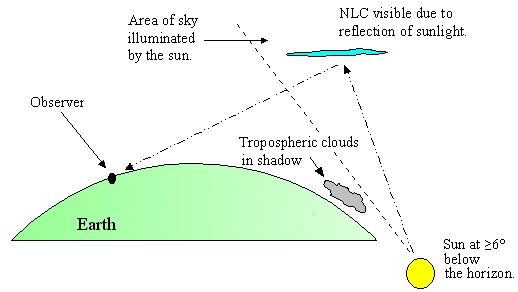
“It’s like Waterworld,” said Benito Ramos, head of the Philippines national disaster agency, referring to a Hollywood movie about a flooded world.

Schools , financial markets, and public and private offices were ordered shut, including outsourcing firms whose corporate clients are mainly from the United States and Europe.

Disaster officials said over half of Manila was swamped by floods as high as three metres, worsened by a high tide and the release of water from dams in surrounding provinces.

President Benigno Aquino, in an emergency meeting briefly interrupted by a power failure at the main army base in Manila, ordered officials to exert maximum effort to aid residents in flooded areas. Officials have deployed army troops, police and emergency workers with rubber boats and amphibious trucks.

The monsoon rains, which dumped about 300 mm (12 inches) or three times the daily average of 80-100 mm from late Monday to Tuesday, were the heaviest in three years, the weather bureau said.

Most major roads in Manila were inundated by knee- to waist-deep floodwaters. Some flights were delayed or cancelled. Power, water and communications in flooded areas were disrupted.

Some of the affected residents were marooned on the roofs of their houses.

“There are about 5,000 people here,” said Ester Ronabio, a public school teacher and volunteer in one of the temporary shelter areas in low-lying Marikina City in the eastern part of Manila. “We can’t control the flow of people.”

In a sign of the difficult scramble to move people to safety, Aquino appealed to an anti-graft court to release dozens of rubber boats held as evidence in a case against senior police officials for use in evacuation efforts.

Residents of Manila expressed concern the rains were a repeat of Typhoon Ketsana which killed more than 700 people and destroyed $1 billion worth of private and public property.

“The floods are so deep where we live, we don’t want a repeat of Typhoon Ketsana a few years ago,” Melanio David, a father of four, told Reuters. “We got scared so we evacuated last night.”

Flash Flood in Philippines on Tuesday, 07 August, 2012 at 05:30 (05:30 AM) UTC.

Description
Torrential rains pounding the Philippine capital on Tuesday paralyzed traffic as waist-deep floods triggered evacuations of tens of thousands of residents and the government suspended work in offices and schools. Incessant downpours set off by the seasonal monsoon overflowed major dams and rivers in Manila and nine surrounding provinces and put authorities on alert. The death toll from last week’s Typhoon Saola, which battered Manila and the northern Philippines for several days, has climbed steadily to 51. The head of the government’s rescue agency, Benito Ramos, said there were no immediate reports of new casualties early Tuesday after the rains pounded already saturated Manila for more than 24 hours. Vehicles and even heavy trucks struggled to navigate water-clogged roads, where hundreds of thousands of commuters were stranded overnight. Many cars were stuck in the muddy waters. The La Mesa dam, which supplies water to the capital of 12 million people, spilled excess water for a second time early Tuesday into the rivers flowing into Quezon city, a middle-class Manila suburb, as well as the neighborhoods of Malabon, Valenzuela and Caloocan, where several villages were submerged. Along the swollen Marikina River, police were deployed to move more than 5,000 residents away from the riverbanks in what Vice Mayor Jose Cadiz said was an enforced evacuation. The operation started after the City Hall sounded the alarm bell. The Philippine Stock Exchange in the financial district of Makati, which was also flooded, was closed Tuesday. Also closed was the U.S. Embassy along Manila Bay in the historic old city, which was drenched out last week when a storm surge pushed the water over the seawall. “The embassy is closed today due to excessive flooding in the streets and concern for the safety of our employees and consular applicants,” Ambassador Harry Thomas Jr. said in an announcement.
07.08.2012 Flash Flood India MultiStates, [States of Uttarakhand, Kerala, Himachal Pradesh and Jammu and Kashmir] Damage level Details

Flash Flood in India on Saturday, 04 August, 2012 at 04:06 (04:06 AM) UTC.

Back

Updated: Tuesday, 07 August, 2012 at 03:39 UTC
Description
Seven people, including five members of a family, were reportedly missing in landslides at various parts of Kannur and Kozhikode districts on Monday evening. The five-member family of Biju of Thundathil house was reportedly washed away at Aanakampoyil at Pulloorampara. There were unconfirmed reports that the body of Biju’s three-and-a-half-year-old son, Kuttan, had been recovered. Two people, identified as Gopalan and Varkey, were reported missing in the landslide at Kodencherry in the district. Rescue operations were going on till late in the night. Heavy rains accompanied by landslides wreaked havoc in Iritty and other high range regions of Kannur district on Monday. Landslides threw life out of gear in Vaniyambara in Ayyankunnu panchayat and in Pulloorampara near Thiruvambadi in Kozhikode. The landslides, besides causing heavy damage to several houses, crops and business establishments, also unleashed flash floods in Vaniyambara and Vallithode. A 10-year-old bridge at Odichikunnu was washed away. A car and a bike moving on the bridge at that time were also swept away. Two people who were inside the car swam to safety and five others were rescued by the local people and the fire force from Iritty. Panic prevailed in the place as people were told that the shutters of the Pazhassi Irrigation Project Division would be opened. The water level in the dam had been steadily rising. However, the officials were able to open only seven or eight shutters. The dam which had a capacity to store 27 metres of water was now already full up to 26 metres, officials said. The officials were trying to open the other shutters to divert the water through another irrigation canal in the area nearby. After inspecting the spot, ADM N.T. Mathew said that five families from Vaniyambara had been shifted to safe locations. “We will provide them free ration and other facilities”, he said. The officials were yet to make an assessment of the damage caused by heavy rains and landslides, he said. One house was totally destroyed in the heavy rains and four others were partially damaged. Crops, especially arecanut palms and plantains were damaged. Thalassery sub-collector Kesavendra Kumar also inspected the spot. Landslides at Pulloorampara and Thiruvambadi areas in Kozhikode district on Monday evening caused heavy damages.

************************************************************************************************************

Solar Activity

3MIN News August 7, 2012: Meteors, Quakes, Storms, Spaceweather

Published on Aug 7, 2012 by

TODAY’S LINKS
Fish Deaths Ohio: http://www.dispatch.com/content/stories/local/2012/08/06/Dead-fish-prompt-clo…

REPEAT LINKS
Spaceweather: http://spaceweather.com/ [Look on the left at the X-ray Flux and Solar Wind Speed/Density]

HAARP: http://www.haarp.alaska.edu/haarp/data.html [Click online data, and have a little fun]

SDO: http://sdo.gsfc.nasa.gov/data/ [Place to find Solar Images and Videos – as seen from earth]

SOHO: http://sohodata.nascom.nasa.gov/cgi-bin/soho_movie_theater [SOHO; Lasco and EIT – as seen from earth]

Stereo: http://stereo.gsfc.nasa.gov/cgi-bin/images [Stereo; Cor, EUVI, HI – as seen from the side]

SunAEON:http://www.sunaeon.com/#/solarsystem/ [Just click it… trust me]

SOLARIMG: http://solarimg.org/artis/ [All purpose data viewing site]

iSWA: http://iswa.gsfc.nasa.gov/iswa/iSWA.html [Free Application; for advanced sun watchers]

NOAA ENLIL SPIRAL: http://www.swpc.noaa.gov/wsa-enlil/cme-based/ [CME Evolution]

NOAA Bouys: http://www.ndbc.noaa.gov/

RSOE: http://hisz.rsoe.hu/alertmap/index2.php [That cool alert map I use]

JAPAN Radiation Map: http://jciv.iidj.net/map/

LISS: http://earthquake.usgs.gov/monitoring/operations/heliplots_gsn.php

Gamma Ray Bursts: http://grb.sonoma.edu/ [Really? You can’t figure out what this one is for?]

BARTOL Cosmic Rays: http://neutronm.bartol.udel.edu//spaceweather/welcome.html [Top left box, look for BIG blue circles]

TORCON: http://www.weather.com/news/tornado-torcon-index [Tornado Forecast for the day]

GOES Weather: http://rsd.gsfc.nasa.gov/goes/ [Clouds over America]

EL DORADO WORLD WEATHER MAP: http://www.eldoradocountyweather.com/satellite/ssec/world/world-composite-ir-…

PRESSURE MAP: http://www.woweather.com/cgi-bin/expertcharts?LANG=us&MENU=0000000000&…

HURRICANE TRACKER: http://www.weather.com/weather/hurricanecentral/tracker

INTELLICAST: http://www.intellicast.com/ [Weather site used by many youtubers]

NASA News: http://science.nasa.gov/science-news/science-at-nasa/

PHYSORG: http://phys.org/ [GREAT News Site!]

************************************************************************************************************

Space

  Earth approaching objects (objects that are known in the next 30 days)

Object Name Apporach Date Left AU Distance LD Distance Estimated Diameter* Relative Velocity
(2005 RK3) 08th August 2012 0 day(s) 0.1843 71.7 52 m – 120 m 8.27 km/s 29772 km/h
(2009 BW2) 09th August 2012 1 day(s) 0.0337 13.1 25 m – 56 m 5.27 km/s 18972 km/h
277475 (2005 WK4) 09th August 2012 1 day(s) 0.1283 49.9 260 m – 580 m 6.18 km/s 22248 km/h
(2004 SC56) 09th August 2012 1 day(s) 0.0811 31.6 74 m – 170 m 10.57 km/s 38052 km/h
(2008 AF4) 10th August 2012 2 day(s) 0.1936 75.3 310 m – 690 m 16.05 km/s 57780 km/h
37655 Illapa 12th August 2012 4 day(s) 0.0951 37.0 770 m – 1.7 km 28.73 km/s 103428 km/h
(2012 HS15) 14th August 2012 6 day(s) 0.1803 70.2 220 m – 490 m 11.54 km/s 41544 km/h
4581 Asclepius 16th August 2012 8 day(s) 0.1079 42.0 220 m – 490 m 13.48 km/s 48528 km/h
(2008 TC4) 18th August 2012 10 day(s) 0.1937 75.4 140 m – 300 m 17.34 km/s 62424 km/h
(2006 CV) 20th August 2012 12 day(s) 0.1744 67.9 290 m – 640 m 13.24 km/s 47664 km/h
(2012 EC) 20th August 2012 12 day(s) 0.0815 31.7 56 m – 130 m 5.57 km/s 20052 km/h
162421 (2000 ET70) 21st August 2012 13 day(s) 0.1503 58.5 640 m – 1.4 km 12.92 km/s 46512 km/h
(2007 WU3) 21st August 2012 13 day(s) 0.1954 76.0 56 m – 120 m 5.25 km/s 18900 km/h
(2012 BB14) 24th August 2012 16 day(s) 0.1234 48.0 27 m – 60 m 2.58 km/s 9288 km/h
1 AU = ~150 million kilometers,1 LD = Lunar Distance = ~384,000 kilometers Source: NASA-NEO


*************************************************************************************************************

Biological Hazards / Wildlife / Hazmat

07.08.2012 Biological Hazard China Hong Kong Special Administrative Region, Hong Kong [Tolo Harbour] Damage level Details

Biological Hazard in China on Tuesday, 07 August, 2012 at 09:42 (09:42 AM) UTC.

Description
A red tide was sighted in Hong Kong waters 3 August 3, an inter-departmental red tide working group reported. Staff of the Leisure and Cultural Services Department and Agriculture, Fisheries and Conservation Department (AFCD) sighted the red tide at Tolo Harbour, including the Yim Tin Tsai and Yim Tin Tsai (East) Fish Culture Zones. It still persists. No associated death of fish has been reported by mariculturists so far. “The red tide was formed by Scrippsiella trochoidea, which is common in Hong Kong waters and non-toxic,” a spokesman for the working group said. The AFCD urged mariculturists at Yim Tin Tsai, Yim Tin Tsai (East), Yung Shue Au and Lo Fu Wat to monitor the situation closely. Red tide is a natural phenomenon. The AFCD’s proactive phytoplankton monitoring programme will continue monitoring red tide occurrences to minimise the impact on the mariculture industry and the public.
Biohazard name: Red Tide
Biohazard level: 0/4 —
Biohazard desc.: This does not included biological hazard category.
Symptoms:
Status:
07.08.2012 HAZMAT Canada Province of Ontario, Limoges [Calypso Theme Waterpark ] Damage level

HAZMAT in Canada on Tuesday, 07 August, 2012 at 19:08 (07:08 PM) UTC.

Description
Thirteen children were taken to the Children’s Hospital of Eastern Ontario this afternoon, after an apparent chlorine leak at the Calypso Water Park, east of Ottawa. Ottawa paramedics spokesperson J.P. Trottier says 14 children, between the ages of 4 and 14, were complaining of irritated and burning eyes. Three had more serious symptoms, including nausea. Thirteen children were transported to CHEO. One was treated at the park by paramedics. The pool where the leak occurred has been closed, and an investigation is under way.
07.08.2012 HAZMAT USA State of Kentucky, [Blue Grass Army Depot] Damage level Details

HAZMAT in USA on Tuesday, 07 August, 2012 at 03:40 (03:40 AM) UTC.

Description
Low levels of a deadly nerve agent have been detected in a chemical weapons igloo containing M55 GB, or sarin, rockets at Blue Grass Army Depot in central Kentucky. The Army Chemical Materials Agency says there’s no danger to people in Madison or surrounding counties and that state and local emergency officials have been notified of the leak. Toxic chemical workers have connected a 1,000 cubic feet-per-minute filter to the igloo’s rear vent. The agency says the leak was discovered during weekly monitoring.

………………………………………….

Experts: Calif refinery fire will boost gas prices

By TERRY COLLINS, Associated Press

RICHMOND, Calif. (AP) — Analysts say a fire at one of the country’s biggest oil refineries will contribute to higher prices at the pump on the West Coast.

The fire at the Chevron refinery in Richmond, about 10 miles northeast of San Francisco, broke out Monday evening.

It sent plumes of black smoke over the San Francisco Bay area and sent scores of people to hospitals with breathing problems before it was out the following morning.

Tom Kloza, chief oil analyst at Oil Price Information Service, says Chevron’s refinery is big and important to the market.

With inventories of gasoline in the region already low compared with the rest of the country, Kloza says pump prices in California and elsewhere on the West Coast will soon average more than $4 per gallon.


*************************************************************************************************************

[In accordance with Title 17 U.S.C. Section 107, this material is distributed without profit, for research and/or educational purposes. This constitutes ‘FAIR USE’ of any such copyrighted material.]

Earthquakes

RSOE EDIS

Date/Time (UTC) Magnitude Area Country State/Prov./Gov. Location Risk Source Details
07.08.2012 07:26:17 2.9 North America United States Montana West Yellowstone There are volcano(s) nearby the epicenter. VulkĂĄn 0 VulkĂĄn 0 USGS-RSOE Details
07.08.2012 07:25:20 4.9 Pacific Ocean – West Philippines Mimaropa Maliig There are volcano(s) nearby the epicenter. VulkĂĄn 0 VulkĂĄn 0 EMSC Details
07.08.2012 07:26:38 4.9 Pacific Ocean – West Philippines Mimaropa Maliig There are volcano(s) nearby the epicenter. VulkĂĄn 0 VulkĂĄn 0 USGS-RSOE Details
07.08.2012 07:25:51 4.6 Asia Japan Fukushima Namie VulkĂĄn 0 VulkĂĄn 0 There are nuclear facilities nearby the epicenter. EMSC Details
07.08.2012 06:35:25 4.6 Asia Japan Fukushima Namie VulkĂĄn 0 VulkĂĄn 0 There are nuclear facilities nearby the epicenter. USGS-RSOE Details
07.08.2012 06:25:30 2.6 Europe Poland Silesian Voivodeship Bazanowice VulkĂĄn 0 There are airport(s) nearby the epicenter. VulkĂĄn 0 EMSC Details
07.08.2012 06:25:55 3.0 South-America Chile Antofagasta Calama VulkĂĄn 0 VulkĂĄn 0 VulkĂĄn 0 EMSC Details
07.08.2012 06:26:22 2.2 Europe Italy Calabria Salerni VulkĂĄn 0 VulkĂĄn 0 VulkĂĄn 0 EMSC Details
07.08.2012 05:20:20 2.2 Europe Italy Calabria Salerni VulkĂĄn 0 VulkĂĄn 0 VulkĂĄn 0 EMSC Details
07.08.2012 05:21:05 3.1 Europe Greece Epirus Kranea VulkĂĄn 0 There are airport(s) nearby the epicenter. VulkĂĄn 0 EMSC Details
07.08.2012 05:21:30 3.3 South-America Chile Antofagasta Calama There are volcano(s) nearby the epicenter. There are airport(s) nearby the epicenter. VulkĂĄn 0 EMSC Details
07.08.2012 06:26:45 2.5 Asia Turkey ??rnak Birlikkoy VulkĂĄn 0 VulkĂĄn 0 VulkĂĄn 0 EMSC Details
07.08.2012 04:21:44 4.8 South America Peru Huanuco Tingo Maria VulkĂĄn 0 VulkĂĄn 0 VulkĂĄn 0 USGS-RSOE Details
07.08.2012 04:20:19 4.7 South-America Peru Huanuco Tingo Maria VulkĂĄn 0 VulkĂĄn 0 VulkĂĄn 0 EMSC Details
07.08.2012 06:27:31 2.7 Caribbean Puerto Rico Vieques Esperanza VulkĂĄn 0 VulkĂĄn 0 VulkĂĄn 0 USGS-RSOE Details
07.08.2012 06:27:07 2.1 Asia Turkey Manisa Golmarmara There are volcano(s) nearby the epicenter. There are airport(s) nearby the epicenter. VulkĂĄn 0 EMSC Details
07.08.2012 04:20:45 3.0 South-America Chile Valparaíso San Antonio VulkĂĄn 0 VulkĂĄn 0 VulkĂĄn 0 EMSC Details
07.08.2012 03:30:31 2.3 North America United States California Greenfield VulkĂĄn 0 VulkĂĄn 0 VulkĂĄn 0 USGS-RSOE Details
07.08.2012 05:21:57 2.5 Asia Turkey Eski?ehir Alpu VulkĂĄn 0 There are airport(s) nearby the epicenter. VulkĂĄn 0 EMSC Details
07.08.2012 06:27:54 2.8 Caribbean Puerto Rico Aguadilla San Antonio VulkĂĄn 0 VulkĂĄn 0 VulkĂĄn 0 USGS-RSOE Details
07.08.2012 03:05:21 5.2 South America Chile Atacama Vallenar VulkĂĄn 0 There are airport(s) nearby the epicenter. VulkĂĄn 0 USGS-RSOE Details
07.08.2012 03:20:19 5.2 South-America Chile Atacama Vallenar VulkĂĄn 0 There are airport(s) nearby the epicenter. VulkĂĄn 0 EMSC Details
07.08.2012 02:40:26 4.9 Asia India Arun?chal Pradesh Along VulkĂĄn 0 VulkĂĄn 0 VulkĂĄn 0 USGS-RSOE Details
07.08.2012 03:20:45 5.0 Asia India Arun?chal Pradesh Along VulkĂĄn 0 VulkĂĄn 0 VulkĂĄn 0 EMSC Details
07.08.2012 02:20:21 4.7 Indonesian Archipelago Indonesia Maluku Utara Tobelo VulkĂĄn 0 VulkĂĄn 0 VulkĂĄn 0 EMSC Details
07.08.2012 01:40:24 4.7 Indonesian archipelago Indonesia Maluku Utara Tobelo VulkĂĄn 0 VulkĂĄn 0 VulkĂĄn 0 USGS-RSOE Details
07.08.2012 00:40:29 2.3 North America United States Alaska Beluga There are volcano(s) nearby the epicenter. VulkĂĄn 0 VulkĂĄn 0 USGS-RSOE Details
07.08.2012 04:21:05 2.0 Europe Greece North Aegean Agia Paraskevi VulkĂĄn 0 There are airport(s) nearby the epicenter. VulkĂĄn 0 EMSC Details
07.08.2012 00:15:25 2.3 Asia Turkey Van Toyga There are volcano(s) nearby the epicenter. There are airport(s) nearby the epicenter. VulkĂĄn 0 EMSC Details
07.08.2012 00:15:48 2.3 Europe Greece North Aegean Kedron VulkĂĄn 0 There are airport(s) nearby the epicenter. VulkĂĄn 0 EMSC Details
06.08.2012 23:35:28 2.1 North America United States Hawaii Volcano There are volcano(s) nearby the epicenter. VulkĂĄn 0 VulkĂĄn 0 USGS-RSOE Details
06.08.2012 23:35:50 2.4 North America United States Hawaii Volcano There are volcano(s) nearby the epicenter. VulkĂĄn 0 VulkĂĄn 0 USGS-RSOE Details
06.08.2012 23:45:28 2.0 North America United States Arizona Cibola There are volcano(s) nearby the epicenter. There are airport(s) nearby the epicenter. VulkĂĄn 0 USGS-RSOE Details
06.08.2012 23:10:29 3.0 North America United States Alaska Ugashik There are volcano(s) nearby the epicenter. VulkĂĄn 0 VulkĂĄn 0 USGS-RSOE Details
07.08.2012 00:16:10 2.1 Asia Turkey Manisa Golmarmara There are volcano(s) nearby the epicenter. There are airport(s) nearby the epicenter. VulkĂĄn 0 EMSC Details
06.08.2012 23:00:27 2.2 North America Canada British Columbia Princeton VulkĂĄn 0 There are airport(s) nearby the epicenter. VulkĂĄn 0 USGS-RSOE Details
06.08.2012 22:35:28 2.6 North America United States Alaska Port Alsworth There are volcano(s) nearby the epicenter. VulkĂĄn 0 VulkĂĄn 0 USGS-RSOE Details
06.08.2012 22:05:24 3.3 South-America Chile Valparaíso San Antonio VulkĂĄn 0 VulkĂĄn 0 VulkĂĄn 0 EMSC Details
06.08.2012 22:05:46 2.5 Europe Poland Lower Silesian Voivodeship Peclaw VulkĂĄn 0 There are airport(s) nearby the epicenter. VulkĂĄn 0 EMSC Details
06.08.2012 22:06:05 3.3 South-America Bolivia Potosí Villa Alota There are volcano(s) nearby the epicenter. There are airport(s) nearby the epicenter. VulkĂĄn 0 EMSC Details
06.08.2012 21:10:52 5.4 Indonesian archipelago Indonesia Maluku Utara Tobelo VulkĂĄn 0 There are airport(s) nearby the epicenter. VulkĂĄn 0 USGS-RSOE Details
06.08.2012 22:06:25 5.5 Indonesian Archipelago Indonesia Maluku Utara Tobelo VulkĂĄn 0 There are airport(s) nearby the epicenter. VulkĂĄn 0 EMSC Details
06.08.2012 21:15:27 3.9 North America United States Alaska Adak There are volcano(s) nearby the epicenter. VulkĂĄn 0 VulkĂĄn 0 USGS-RSOE Details
06.08.2012 21:00:27 2.8 Europe Italy Emilia-Romagna San Prospero VulkĂĄn 0 There are airport(s) nearby the epicenter. VulkĂĄn 0 EMSC Details
06.08.2012 21:11:11 3.8 Caribbean Dominican Republic La Altagracia San Rafael del Yuma VulkĂĄn 0 There are airport(s) nearby the epicenter. VulkĂĄn 0 USGS-RSOE Details
06.08.2012 21:00:49 3.0 Asia Turkey Antalya Beykonak VulkĂĄn 0 VulkĂĄn 0 VulkĂĄn 0 EMSC Details
06.08.2012 19:35:33 2.2 North America United States California La Jolla VulkĂĄn 0 There are airport(s) nearby the epicenter. There are nuclear facilities nearby the epicenter. USGS-RSOE Details
06.08.2012 18:55:33 2.1 North America United States Alaska Silver Springs There are volcano(s) nearby the epicenter. VulkĂĄn 0 VulkĂĄn 0 USGS-RSOE Details
06.08.2012 19:00:26 2.7 Asia Turkey ??rnak Bisbin VulkĂĄn 0 VulkĂĄn 0 VulkĂĄn 0 EMSC Details
06.08.2012 17:55:34 2.6 North America United States Alaska Petersville VulkĂĄn 0 VulkĂĄn 0 VulkĂĄn 0 USGS-RSOE Details

……………………………………………………

4.4-Magnitude Quake Rattles Scandinavian Sea

COPENHAGEN, Denmark August 6, 2012 (AP)

Danish geologists say a 4.4-magnitude quake has rattled the seabed between Denmark and Sweden, causing no damage or casualties.

Trine Dahl-Jensen of the Geological Survey of Denmark and Greenland (GEUS) said Monday’s quake was “pretty strong” by Danish standards.

Dahl-Jensen says such quakes happen once or twice a decade.

The epicenter was 20 kilometers (12.4 miles) southeast of the Danish island of Anholt in the Kattegat Sea.

Media in Denmark and Sweden reported that residents in the two Scandinavian countries woke up when they felt the earth shake at 0257 GMT (10:57 p.m. EDT Sunday).

Quake felt in rural Central Calif. community

The Associated Press

COALINGA, Calif. — A magnitude-4.5 earthquake has shaken a rural area of Central California.

A U.S. Geological Survey computer-generated report says Monday’s 12:36 a.m. quake was centered 16 miles south-southwest of Coalinga in the San Joaquin Valley and 123 miles southeast of San Jose.

A Coalinga police officer says several people have reported feeling the quake but there are no reports of damage.

Read more here: http://www.sacbee.com/2012/08/06/4697133/quake-felt-in-rural-central-calif.html#storylink=cpy

**********************************************************************************************************

Volcanic Activity

Visitors warned off erupting volcano

PALOMA MIGONE

White Island

STEAMING: GNS confirms that ‘volcanic eruption is underway’, although there is little or no ash being emitted.

White Island volcano has erupted, prompting GNS Science to advise visitors to take extra care.

The island, located about 50 kilometres off the coast of Whakatane, is an active volcano and a popular tourist spot.

Its web camera captured the small eruption from Crater Lake, GNS Science volcanologist Michael Ronsenberg said.

“These phenomena are not unknown for While Island, but this is the first substantial confirmation that small scale eruptions are now occurring on the island and confirms the risk to visitors has increased,” he said.

“Eruptions can occur at any time with little or no warning. We advise extra caution should be taken, if visiting the island.”

GNS has changed the volcano’s code from “experiencing signs of elevated unrest above known background levels” to “volcanic eruption is underway with no or minor ash emissions”.

The alert level has also changed from one to two due to “minor eruptive activity”.

It follows a code change last week when scientists discovered water levels in Crater Lake rose by about 3m to 5m overnight and the number of tremors had increased.

There was a particularly stronger seismic episode recorded Sunday morning, ending in a volcanic earthquake at 4.54am that day.

Rosenberg said: “[The earthquake] had a sound signal, which meant something happened on the surface. So we went back and looked at the camera images.”

“Obviously being at night time, there was no visual observations and initially we weren’t able to determine what that small event was.

“But we’ve narrowed it down and recognise that there has been full hydrothermal eruption.”

Rosenberg said there had not been any further eruptions, and the number of tremors had decreased.

“It’s now at similar levels to before the weekend.”

GNS Science was “paying close attention” to the volcano as the last “gentle eruption” had been in early 2001.

White Island also experienced a “moderate-sized explosion” in July 2000, when fresh lava was pushed out.

“In the past this kind of activity has increased to small eruptions that produce ash, and that ash could drift as far as the mainland,” Rosenberg said.

“We can’t predict what the volcano is going to do and we are not making any forecasts, but yes, it’s certainly possible that the activity could ramp up again.”

Underwater Volcano Found off West Iceland?

A mountain which the Icelandic Marine Research Institute (Hafró) discovered on the ocean floor west off the Snæfellsnes peninsula in West Iceland during an expedition earlier this summer may turn out to be a previously unknown volcano.

fishingship_ipa

A fishing ship with Snæfellsjökull, the glacier-covered volcano on the tip of Snæfellsnes in the background. Copyright: Icelandic Photo Agency.

“Multi-laser measurements […] revealed a large underwater mountain deep off the foot of the continental shelf approximately 120 nautical miles west of Snæfellsnes,” a statement from Hafró reads, according to Fréttablaðið.

The mountain, which is at a depth of 950 to 1,400 meters is around 450 meters high, similar to Ingólfsfjall in south Iceland. However, it extends over 300 square kilometers, which is ten times the square measure of Ingólfsfjall.

The shape of the mountain is very similar to that of table mountains and it appears to be geologically young.

“The analysis of a rock sample from the mountain will determine whether this is the case or whether it is a volcano connected with an old drift belt, which might mean that it is 20 million years old,” the statement continues.

During the expedition multi-laser measurements were made between West Iceland and Greenland to map the shape of the ocean floor in these commonly-used fishing grounds and explore the environment of powerful ocean currents.

A total of 9,000 square kilometers were covered during the 11-day expedition.

ESA

Mt Tongariro eruption: Code red

Can you help? If you have tips, photos or video of the eruption, please email us.

An aerial from a Mountain Air flight over the Tongariro National Park. Photo / Greg Bowker

Expand

An aerial from a Mountain Air flight over the Tongariro National Park. Photo / Greg Bowker

A thick ash cloud is covering much of the central North Island after Mt Tongariro erupted for the first time in more than a century late last night.

The volcanic alert level for Mt Tongariro has risen from 1 to 2, while the aviation colour code has been raised to red.

Roads are closed, flights are likely to be disrupted and nearby residents are advised to stay indoors as ash and rock spews from the mountain.

Turoa Ski Area manager Chris Thrupp told Firstline the ski field remains open and has not been advised to close. He said the ash has not drifted to Ruapehu, south of Tongariro.

“The ash is the concern – if the wind changes, which we don’t believe it will.”

GNS science is reporting that about 11.50pm on Monday night ash fall began to be reported in the volcano’s vicinity – it has since been reported as far east as SH5 near Te Haroto and in Napier.


Mt Tongariro eruption: Where will the ash go?

It is the first time the mountain has erupted since 1897.

GNS duty volcanologist Michael Rosenberg told Radio New Zealand that some people are reported to have left their houses on the southern shores of Lake Rotoaira, though no formal notices of evacuation have been issued so far by Civil Defence.

He said residents in the area have told GNS of hearing several loud explosions, lightning and plumes of smoke and police have been told by an onlooker that “a new hole in the side of the mountain” had formed.

They have also reported bright red rocks flying out of the mountain.

The eruption reportedly happened at the Te Mari Craters, which are close to the Ketetahi Hot Springs on the northern side of the mountain.

There have been no further eruptions since midnight, according to GNS seismic records.

Mr Rosenberg said while volcanologists have been monitoring small earthquakes under the mountain in the past few weeks, the eruption was “quite unexpected”.

Activity at the mountain is expected continue for some time, bit it was “anyone’s guess” whether there would be larger eruptions.

AREAS AFFECTED

Civil defence spokesman Vince Cholewa told Newstalk ZB ash could reach those living in Waikato, Hawke’s Bay, Gisborne, Manawatu-Wanganui, Bay of Plenty and Taranaki.

“The advice to people is to stay indoors, because volcanic ash can obviously be a health hazard, if they’re indoors please close windows and doors to try and limit the entry of ash.”

Mr Cholewa says at this stage not all areas alerted are affected by ash, but that situation could change.

“We’re working actively with GNS Science who operate the monitoring equipment on the mountains, and with police so all the information from the ground is being gathered, and decisions will be based on that information.

“Evacuations have not been ordered, please listen to the radio for advice from local authorities and police, any evacuations would be issued at that level, and based on the evidence from GNS Science.”

Police are sending search and rescue teams up Mt Tongariro at first light to check no one is stranded in huts. However, they say there have been no reports of injuries or damage.

ROADS

The police have closed State Highway 1 between Rangipo and Waiouru (Desert Road) and SH46 west of Rangipo. SH47 and 4 remain open at this stage as does SH5.

Motorists are being advised to avoid travel in the area and these closures will be re-assessed once daylight reveals the extent of the ash cloud.

Truck driver Bryn Rodda told Radio New Zealand thick dust meant there was poor visibility on the Desert Road when he passed through last night.

“I could see this big cloud – it looked like a fist, basically, at an angle across the sky – and about the wrist section of the fist there was an orange ball of flash that I saw.”
Clayton Bolt, a passing motorist told RadioLive that he saw a massive white cloud coming from the side of Mt Tongariro.

“I put my foot down. I said, I’m going.”

AVIATION

Civil Aviation Authority manager of meteorology Peter Lechner said the plume is leading off to the east and south east. affecting a zone of airspace stretching as far as from Tongariro to north of Gisborne then south to Hawkes Bay and possibly northern Wairarapa.

The CAA alerted all aircraft using a volcanic ash advisory system, working with MetService.

Mr Lechner said that ash can build up in the turbines of aeroplanes and helicopters, causing engines to stall.

“It can result in significant flight risk.”

WEATHER

WeatherWatch chief analyst Philip Duncan said westerlies will continue to blow the ash east to south east of the mountain.

“The winds don’t look especially strong over the next few days as the centre of a low crosses the North Island – the lighter the winds are the more ash will fall locally around the mountain and less likely to cause widespread disruptions further afield.”

The Ministry of Civil Defence & Emergency Management (MCDEM) is currently assessing information with the assistance of GNS scientific advisors.

It has not yet activated the National Crisis Management Centre which is called upon in times of emergency like the Christchurch earthquake.

WHITE ISLAND

New Zealand’s other high profile active volcano, White Island, also had its alert level raised from 1 to 2 on Monday after a small eruption was recorded in its crater lake.

– Herald Online

07.08.2012 Volcano Activity New Zealand Northland, [Tongariro Volcano] Damage level Details

Volcano Activity in New Zealand on Monday, 06 August, 2012 at 17:51 (05:51 PM) UTC.

Description
The volcanic alert level for Mt Tongariro has risen from 1 to 2 after the central North Island volcano erupted for the first time in more than a century late last night. GNS science is reporting that at approximately 11:50pm on Monday night ash fall began to be reported in the volcano’s vicinity – it has since been reported as far east as SH5 near Te Haroto and in Napier. GNS duty volcanologist Michael Rosenberg told Radio New Zealand that some people are reported to have left their houses on the southern shores of Lake Rotoaira, though no formal notices of evacuation have been issued so far by Civil Defense. He said residents in the area have told GNS of hearing several loud explosions, lightning and plumes of smoke and police have been told by an onlooker that “a new hole in the side of the mountain” had formed. They have also reported bright red rocks flying out of the mountain. The eruption reportedly happened at the Te Mari Craters, which are close to the Ketetahi Hot Springs on the northern side of the mountain. Civil defence spokesman Vince Cholewa told NewstalkZb ash could reach those living in Waikato, Hawke’s Bay, Gisborne, Manawatu-Wanganui, Bay of Plenty and Taranaki. “The advice to people is to stay indoors, because volcanic ash can obviously be a health hazard, if they’re indoors please close windows and doors to try and limit the entry of ash.” Mr Cholewa says at this stage not all areas alerted are affected by ash, but that situation could change. “We’re working actively with GNS Science who operate the monitoring equipment on the mountains, and with police so all the information from the ground is being gathered, and decisions will be based on that information. “Evacuations have not been ordered, please listen to the radio for advice from local authorities and police, any evacuations would be issued at that level, and based on the evidence from GNS Science.”

Due to possible danger to the public the police have closed SH1 between Rangipo and Waiouru (Desert Road) and SH46 west of Rangipo. SH47 and 4 remain open at this stage as does SH5. Motorists are being advised to avoid travel in the area and these closures will be re-assessed once daylight reveals the extent of the ash cloud. A truck driver has told Radio New Zealand that the ash cloud has caused thick dust and reduced visibility on the Desert Road. Bryn Rodda said he saw a large cloud rising from the mountain with orange flashes. Civil Aviation Authority manager of meteorology Peter Lechner told NewstalkZb the plume is leading off to the east and south east. “Flight operations to the west of the plume should remain unaffected, however operations to the eastern half of the North Island will have some difficulty at this stage.” Mr Lechner says a frontal system is on its way which should disperse the cloud, but that depends on whether there are further eruptions. Police are sending search and rescue teams up Mt Tongariro at first light to check no one is stranded in huts. However, they say there have been no reports of injuries or damage. The Ministry of Civil Defence & Emergency Management (MCDEM) is currently assessing information with the assistance of GNS scientific advisors. It has not yet activated the National Crisis Management Centre which is called upon in times of emergency like the Christchurch earthquake. New Zealand’s other high profile active volcano, White Island, also had its alert level raised from 1 to 2 on Monday after a small eruption was recorded in its crater lake.

***********************************************************************************************************

Extreme Temperatures/ Weather

Excessive Heat Warning

PHOENIX AZ

Excessive Heat Watch

LAS VEGAS NV
PHOENIX AZ

Heat Advisory

TULSA OK
PENDLETON OR
NORMAN OK
Today Heat Wave Bulgaria [Statewide] Damage level Details

Heat Wave in Bulgaria on Tuesday, 07 August, 2012 at 05:29 (05:29 AM) UTC.

Description
Historically high temperatures were recorded in 28 locations throughout Bulgaria on Monday, the country’s National Institute of Meteorology and Hydrology (NIMH) said. At 3 p.m. local time (0200 GMT), the temperature in Ruse by the Danube River was 41 degrees Celsius. Pleven in northern Bulgaria recorded 40 degrees Celsius, followed by Sandanski in the southwest of the country at 39.6 degrees Celsius. Meanwhile, temperatures in the capital Sofia also hit 34.6 degrees Celsius. Temperatures were unusually high even in the mountains, NIMH said. At Botev peak, temperatures reached 17.5 degrees Celsius, 25.2 degrees Celsius at Murgash peak, and 26.5 degrees Celsius at Rozhen peak. Record-high temperatures were reported also on the Black Sea coast in the towns of Ahtopol and Varna at 35 degree Celsius, and cape of Kaliakra at 32.8 degree Celsius. Temperatures will remain high on Tuesday, after which they should return to what is considered normal for the season, NIMH said.
06.08.2012 Extreme Weather USA State of Pennsylvania, Tunkhannock Township [Pocono Raceway] Damage level Details

Extreme Weather in USA on Monday, 06 August, 2012 at 14:51 (02:51 PM) UTC.

Description
NASCAR fans at Pocono Raceway were advised over public address systems and through social media to take cover when lightning and heavy rain hit the track near the end of the race. The warnings weren’t enough to avoid tragedy at the track on Sunday. Lightning strikes at Pocono after a rain-shortened NASCAR race killed one fan and injured nine others, one critically, racetrack officials said. Multiple lightning strikes occurred behind the racetrack’s grandstands and outside one of the gates as fans were leaving, Pocono spokesman Bob Pleban said. It wasn’t immediately clear how many of the fans were actually struck by the lightning itself or were injured by related jolts. “Unfortunately, a member of our raceway family here, a fan, has passed away,” Pocono President Brandon Igdalsky said in announcing the death. He provided no details about the victim but expressed condolences to his family. Igdalsky later posted on Twitter, “My family and I are praying for all those that were involved in the lightning strikes. … Difficult evening for all.” The victim was in or near his car in a parking lot after the race had ended when lightning struck the car, Monroe County Coroner Bob Allen said. Bystanders performed CPR on the man, who had gone into cardiac arrest, until paramedics arrived, Allen said. They took him to the track’s medical facility, where efforts to revive him failed. He was pronounced dead at a hospital.

The Pennsylvania 400 was called because of storms, with 98 of the 160 scheduled laps completed. As the storm approached, the track posted messages on its Twitter page to more than 22,000 followers near the end of the race encouraging fans to “seek shelter as severe lightning and heavy winds are in our area.” The attendance was estimated by the track at 85,000. Public address announcements were made before the storm and the end of the race for fans to take shelter and evacuate the grandstands, Pleban said. Racetrack officials were reviewing the logs of when the announcements were made, he said. There was no order to evacuate the track premises. Jeff Gordon, who won the race, said at a post-race news conference that he could hear a huge crack as he walked down the pit road during the storm. “You could tell it was very close,” he said. “I mean, that’s the thing that’s going to take away from the victory, is the fact that somebody was affected by that.” Kyle Manger, a spectator from New Jersey, told The Sporting News that he saw people hit by lightning near the Turn 3 grandstands. He said when the severe weather began, he and some friends ran to their truck. “The visibility was very poor and all of a sudden (I) saw a bolt of lightning right in front of our windshield,” he said. “When it became a little more visible, we saw two bodies next to a destroyed tent with people scrambling.” One person remained hospitalized in critical condition at Lehigh Valley Hospital Center, Pleban said. Three people were taken to hospitals with minor to moderate injuries, and five others were treated on the scene, he said. “We are deeply saddened that a fan has died and others were injured by lightning strikes following today’s race at Pocono,” NASCAR spokesman David Higdon said. “Our thoughts are with them as well as those affected by this unfortunate accident.” Gordon’s team, Hendrick Motorsports, also offered sympathies on Twitter, writing, “Our thoughts and prayers are with everyone affected by the lightning” at Pocono Raceway.

Red Flag Warning

FIRE WEATHER MESSAGE

GLASGOW MT
BILLINGS MT

Fire Weather Watch

POCATELLO ID
BOISE ID

Extreme Fire Danger

RAPID CITY SD
06.08.2012 Forest / Wild Fire Italy Sicily, [Zingaro National Park] Damage level Details

Forest / Wild Fire in Italy on Monday, 06 August, 2012 at 20:15 (08:15 PM) UTC.

Description
Around 900 holidaymakers from Italy and abroad were moved from hotels and camping areas as the fire hit the Zingaro National Park on the island’s northwest tip overlooking the Tyrrhenian Sea. “The Zingaro reserve went up in flames,” said Matteo Rizzo, Mayor of San Vito Lo Capo, just north of the park. Firefighters, forest patrols and volunteers worked for 12 hours to bring the fire under control and a school was opened in San Vito Lo Capo to house evacuees while others slept outdoors in the stifling heat. Mr Rizzo said the damage from the Zingaro blaze could have been reduced if firefighters had received air support. “I realise that there were a number of fires in Sicily and the situation was rather serious, but it is inconceivable that one of the most beautiful and oldest reserves in Sicily went up in smoke because no one lifted a finger.” Park officials said on Monday the reserve would remain closed to the public while they assessed the full extent of the park’s vegetation and wildlife which includes 40 different birds, rabbits, snakes and weasels. The reserve covers 4,000 acres and beneath its dramatic cliffs there are coves and grottoes stretching for four miles of the coast. One hotel owner said electricity and water supplies had been cut off and telephone lines were down while emergency workers continued to secure the area as temperatures soared close to 95F (35C).
06.08.2012 Forest / Wild Fire USA State of Washington, [Near to Chelan ] Damage level Details

Forest / Wild Fire in USA on Monday, 06 August, 2012 at 13:52 (01:52 PM) UTC.

Description
A wildfire that has burned about 1,000 acres of grass and brush near Chelan also threatens 14 homes or outbuildings. Chelan County sheriff’s Cpl. Jason Reinfeld told The Wenatchee World the owners were advised of the danger. The fire broke out about noon Sunday off Highway 97. State, federal and Chelan County crews are attacking the fire from the ground and air using two air tankers and three helicopters, which are dipping from the Columbia River.

***********************************************************************************************************

Storms, Flooding

Active tropical storm system(s)
Name of storm system Location Formed Last update Last category Course Wind Speed Gust Wave Source Details
Ernesto (AL05) Atlantic Ocean 02.08.2012 07.08.2012 Hurricane I 300 ° 102 km/h 120 km/h 5.49 m NOAA NHC Details

 Tropical Storm data

Share:
Storm name: Ernesto (AL05)
Area: Atlantic Ocean
Start up location: N 12° 36.000, W 50° 36.000
Start up: 02nd August 2012
Status: 01st January 1970
Track long: 2,163.67 km
Top category.:
Report by: NHC
Useful links:

Past track
Date Time Position Speed
km/h
Wind
km/h
Gust
km/h
Category Course Wave Pressure Source
02nd Aug 2012 04:08:45 N 12° 36.000, W 50° 36.000 30 56 74 Tropical Depression 285 16 1008 MB NHC
03rd Aug 2012 04:49:11 N 13° 24.000, W 58° 18.000 35 83 102 Tropical Storm 275 20 1005 MB NHC
04th Aug 2012 05:16:42 N 13° 54.000, W 65° 36.000 30 83 102 Tropical Storm 275 16 1003 MB NHC
05th Aug 2012 05:35:24 N 15° 24.000, W 72° 42.000 35 93 111 Tropical Storm 285 16 1007 MB NHC
06th Aug 2012 05:25:12 N 15° 0.000, W 79° 42.000 24 83 102 Tropical Storm 270 15 1003 MB NHC
Current position
Date Time Position Speed
km/h
Wind
km/h
Gust
km/h
Category Course Wave
feet
Pressure Source
07th Aug 2012 05:16:51 N 17° 0.000, W 82° 42.000 20 102 120 Hurricane I 300 ° 18 994 MB NHC
Forecast track
Date Time Position Category Wind
km/h
Gust
km/h
Source
08th Aug 2012 12:00:00 N 18° 54.000, W 89° 0.000 Tropical Depression 83 102 NHC
08th Aug 2012 00:00:00 N 18° 18.000, W 86° 48.000 Hurricane II 130 157 NHC
09th Aug 2012 00:00:00 N 19° 18.000, W 91° 6.000 Tropical Depression 65 83 NHC
10th Aug 2012 00:00:00 N 19° 30.000, W 94° 48.000 Hurricane I 111 139 NHC
11th Aug 2012 00:00:00 N 19° 24.000, W 97° 24.000 Tropical Depression 93 111 NHC
12th Aug 2012 00:00:00 N 19° 12.000, W 99° 24.000 Tropical Depression 37 56 NHC
Haikui (12W) Pacific Ocean 03.08.2012 07.08.2012 Typhoon I 280 ° 120 km/h 148 km/h 4.57 m JTWC Details

Tropical Storm data

Share:
Storm name: Haikui (12W)
Area: Pacific Ocean
Start up location: N 24° 24.000, E 139° 48.000
Start up: 03rd August 2012
Status: 01st January 1970
Track long: 1,009.14 km
Top category.:
Report by: JTWC
Useful links:

Past track
Date Time Position Speed
km/h
Wind
km/h
Gust
km/h
Category Course Wave Pressure Source
03rd Aug 2012 09:08:44 N 24° 24.000, E 139° 48.000 24 56 74 Tropical Depression 295 20 JTWC
04th Aug 2012 05:17:37 N 24° 54.000, E 134° 12.000 35 65 83 Tropical Storm 275 20 JTWC
04th Aug 2012 10:54:52 N 25° 30.000, E 132° 48.000 30 65 83 Tropical Storm 295 16 JTWC
05th Aug 2012 05:42:49 N 26° 48.000, E 129° 12.000 17 83 102 Tropical Storm 290 16 JTWC
06th Aug 2012 05:33:59 N 27° 12.000, E 126° 0.000 7 102 130 Tropical Storm 270 12 JTWC
Current position
Date Time Position Speed
km/h
Wind
km/h
Gust
km/h
Category Course Wave
feet
Pressure Source
07th Aug 2012 05:22:17 N 27° 24.000, E 123° 54.000 9 120 148 Typhoon I 280 ° 15 JTWC
Forecast track
Date Time Position Category Wind
km/h
Gust
km/h
Source
08th Aug 2012 00:00:00 N 28° 48.000, E 121° 42.000 Typhoon I 111 139 JTWC
08th Aug 2012 12:00:00 N 29° 30.000, E 120° 30.000 Tropical Depression 83 102 JTWC
09th Aug 2012 00:00:00 N 30° 12.000, E 119° 42.000 Tropical Depression 65 83 JTWC
10th Aug 2012 00:00:00 N 31° 6.000, E 120° 36.000 Tropical Depression 37 56 JTWC
13W Pacific Ocean 05.08.2012 07.08.2012 Tropical Depression 330 ° 83 km/h 102 km/h 4.57 m JTWC Details

 Tropical Storm data

Share:
Storm name: 13W
Area: Pacific Ocean
Start up location: N 23° 6.000, E 161° 36.000
Start up: 05th August 2012
Status: Active
Track long: 408.00 km
Top category.:
Report by: JTWC
Useful links:

Past track
Date Time Position Speed
km/h
Wind
km/h
Gust
km/h
Category Course Wave Pressure Source
05th Aug 2012 05:44:20 N 23° 6.000, E 161° 36.000 13 46 65 Tropical Depression 195 10 JTWC
06th Aug 2012 05:31:12 N 25° 48.000, E 162° 12.000 9 65 83 Tropical Storm 240 10 JTWC
Current position
Date Time Position Speed
km/h
Wind
km/h
Gust
km/h
Category Course Wave
feet
Pressure Source
07th Aug 2012 05:20:10 N 29° 0.000, E 161° 54.000 13 83 102 Tropical Depression 330 ° 15 JTWC
Forecast track
Date Time Position Category Wind
km/h
Gust
km/h
Source
08th Aug 2012 00:00:00 N 31° 36.000, E 159° 18.000 Tropical Depression 83 102 JTWC
08th Aug 2012 12:00:00 N 32° 54.000, E 157° 42.000 Tropical Depression 74 93 JTWC
09th Aug 2012 00:00:00 N 34° 48.000, E 155° 36.000 Tropical Depression 74 93 JTWC
10th Aug 2012 00:00:00 N 39° 42.000, E 151° 36.000 Tropical Depression 65 83 JTWC

……………………………………………..

Above 45 Killed by Typhoon in the Philippines

Imagen activa

Manila, Aug 6 (Prensa Latina) More than 45 people died and six others missing due to Typhoon Saola in the northern region of Philippines, reported on Monday the National Center for Disaster Prevention.

The rains and flooding caused further serious damage to 74 roads, 7, 000 homes and the evacuation of about 200, 000 people still housed in improvised centers, according to the press.

Landslides and overflowing dam flooded much of Manila, the capital, especially in the areas near the sea, other media reported as Rappler website.

Between May and November, during rainy season in the Philippines, the archipelago is hit by an average of 15 to 20 typhoons that affect the entire region of Southeast Asia.

sus/cmf/lac/pgh

Modificado el ( lunes, 06 de agosto de 2012 )

Flash Flood Watch

TALLAHASSEE FL

Flood Advisory

TIYAN GU
TALLAHASSEE FL
07.08.2012 Flash Flood India MultiStates, [States of Uttarakhand, Kerala, Himachal Pradesh and Jammu and Kashmir] Damage level Details

Flash Flood in India on Saturday, 04 August, 2012 at 04:06 (04:06 AM) UTC.

Description
Hundreds of people residing near Beas river have been evacuated to safe places after flash flood caused by torrential rain over Dhundi peaks at south portal of Rohtang tunnel flooded the Seri rivulet, a tributary to Beas river, on Friday at 8pm. People living close to river between Palchan and Kullu are being evacuated and traffic on national highway has been stopped. Till last report received from Palchan (near Dhundi) at 10.30pm, level of the river was rising continuously and police were evacuating the people from Bahang village, 6km from Manali. According to police, there is no report of any casualty. Sandeep Kumar, a resident of Bahang village, said people are trying to save the household accessories amid chaotic atmosphere and conditions have become even worse after power failure. “Everything was normal till late evening but the situation changed suddenly after 8pm when river water, mixed with sludge, started engulfing its banks. People are risking their lives to remove the household stuffs,” he said. An engineer working with a hydel project near Palchan said over phone that roaring sound of river is shaking the foundation of the houses. “Nobody is going to sleep tonight. Villagers have gathered at many places and are guarding the river banks with floodlights,” he said. According to villagers it is a cloudburst which might have caused devastation at its source on mountains. Kullu deputy commissioner Amitabh Awasthi said , police are patrolling the river banks and have directed people to move to safe places. “We have closed the traffic on national highway. We shall keep an eye on the situation throughout the night,” he said.
Today Flash Flood Philippines National Capital Region, Quezon City Damage level Details

Flash Flood in Philippines on Tuesday, 07 August, 2012 at 05:30 (05:30 AM) UTC.

Description
Torrential rains pounding the Philippine capital on Tuesday paralyzed traffic as waist-deep floods triggered evacuations of tens of thousands of residents and the government suspended work in offices and schools. Incessant downpours set off by the seasonal monsoon overflowed major dams and rivers in Manila and nine surrounding provinces and put authorities on alert. The death toll from last week’s Typhoon Saola, which battered Manila and the northern Philippines for several days, has climbed steadily to 51. The head of the government’s rescue agency, Benito Ramos, said there were no immediate reports of new casualties early Tuesday after the rains pounded already saturated Manila for more than 24 hours. Vehicles and even heavy trucks struggled to navigate water-clogged roads, where hundreds of thousands of commuters were stranded overnight. Many cars were stuck in the muddy waters. The La Mesa dam, which supplies water to the capital of 12 million people, spilled excess water for a second time early Tuesday into the rivers flowing into Quezon city, a middle-class Manila suburb, as well as the neighborhoods of Malabon, Valenzuela and Caloocan, where several villages were submerged. Along the swollen Marikina River, police were deployed to move more than 5,000 residents away from the riverbanks in what Vice Mayor Jose Cadiz said was an enforced evacuation. The operation started after the City Hall sounded the alarm bell. The Philippine Stock Exchange in the financial district of Makati, which was also flooded, was closed Tuesday. Also closed was the U.S. Embassy along Manila Bay in the historic old city, which was drenched out last week when a storm surge pushed the water over the seawall. “The embassy is closed today due to excessive flooding in the streets and concern for the safety of our employees and consular applicants,” Ambassador Harry Thomas Jr. said in an announcement.
06.08.2012 Flash Flood USA State of Tennessee, Johnson City Damage level Details

Flash Flood in USA on Monday, 06 August, 2012 at 12:18 (12:18 PM) UTC.

Description
Heavy rains pounded northeast Tennessee Sunday, including downtown Johnson City, where emergency crews in inflatable boats rescued people trapped in their homes and in their cars on flooded streets. Johnson City Schools announced their start on Monday is postponed because of the storm damage. The city’s garage complex flooded and several were buses under water, leading the city to cancel transit service for Monday. WTFM radio reported shelters were still open at schools in Unicoi and Jonesborough early Monday. Streams throughout the region overflowed across roads and into homes. Houses and apartments in several areas are surrounded by water at the Mall at Johnson City’s parking lot was covered by high water, stranding numerous vehicles. Sections of Washington, Carter and Unicoi counties also were flooded. The National Weather Service said three to four inches of rain fell within an hour’s time across upper northeast Tennessee during the height of the storm. And more rain was expected through the night. At least 10 people were rescued from their homes in Washington County, and in Unicoi County, officers and volunteer firefighters were evacuating other areas as well. In down downtown Johnson City, a portion of one street washed away into a creek, officials said. “Occasionally, we’ve been up to our gun belt in water, but it’s starting to subside,” said city police Lt. Gerald Harrell. “We are actively answering every call for service that we have. It may be taking us just a tad bit longer, but we’re getting to each and every one and we will get to each and every one,” Harrell said.Police urged people to stay home and avoid any local travel if possible and emergency shelters were open. Elizabethton also was hit hard, officials there said. “We’ve got flooding all over,” Carter County Sheriff Chris Mathes said. Unicoi County Sheriff Mike Hensley said when he first was called at 7 p.m. or so, it was just drizzling. “When I came in, it was just unreal. The water was coming up and I saw we were going to have serious, serious problems,” he said. About 4,000 customers, most in Johnson City, had no power but officials expected it to be restored quickly.


************************************************************************************************************

Epidemic Hazards / Diseases

05.08.2012 Epidemic Hazard Tanzania Kagera Region, [Nyakahanga area] Damage level Details

Epidemic Hazard in Tanzania on Sunday, 05 August, 2012 at 17:33 (05:33 PM) UTC.

Description
A team of medical experts from Dar es Salaam was yesterday dispatched to Kagera region to further examine the two patients believed to be suffering from the Ebola hemorrhagic fever. But as the team of medical experts was sent to Kagera region, the Ministry of Health and Social Welfare subsequently confirmed the outbreak of the deadly fever in the western part of the country. Confirming the reports, the Deputy Minister for Health and Social Welfare, Dr Seif Seleman Rashid, also said that a team of medical experts was still diagnosing a patient in efforts to establish the symptoms. In the meantime, reports from Nyakahanga designated hospital in Karagwe district, Kagera region indicate that there were two patients including a child, suspected to be suffering from the deadly fever that has rocked neighbouring Uganda. According to one of the doctors who diagnosed the patient at Karagwe’s Nyakahanga hospital, preliminary findings show that the victim might have contacted the Ebola virus. However, the doctor who requested anonymity told the Guardian on Sunday that ‘further medical examination’ would be conducted to gather more evidence about the possible outbreak of Ebola, adding that the patient had since been quarantined pending final results. According to the doctor, the ‘Ebola patient’ was brought to the hospital on Friday morning and, upon diagnosis, it was established that the patient had suffered from Ebola. The patient who is a six-year-old child was brought to the Mulongo hospital by his mother from a village close to the Uganda-Tanzania boarder after the child developed severe symptoms.

“We are doing further medical examination on a patient … we will tell the general public once it is confirmed that we are dealing with Ebola virus infections,” the doctor said, adding that currently the patient alleged to have been infected was admitted in a separate room and now lives in isolation from other patients at the hospital. He said preliminary check-ups found out that the diagnosis had all signs showed clear symptoms of Ebola – after which he ordered the patient to be admitted for closer monitoring locally, and further medical examination by medical experts from the ministry headquarters. He added that the patient had since been placed in a special intensive care room which is out of bounds for all other people — apart from his mother who is taking care of the patient. However, he said, this was a medical rule aimed at avoiding quick spread of the deadly disease Another patient also believed to have crossed the boarder from Uganda was admitted at the hospital as well, but medical investigations of his deteriorating health conditions were still not completed by Saturday evening. As a precaution, the doctor said his hospital team and the district health workers had since started warning people in surrounding villages to take immediate measures whenever they come across such patients. He has also warned the people living closer to the border with Uganda to be careful not to come into contact with any person whom they see vomiting or bleeding – clear signs of someone suffering from Ebola.

On Wednesday this week, Dr. Mwinyi told visibly alarmed legislators in Dodoma that a team of medical experts had been dispatched to the border with Uganda, fully equipped with protective gear and medical supplies. The minister advised the general public especially those living in the northern regions of Kagera, Mara, Mwanza and Kigoma — some of which share the border crossings with Uganda — to take precautions because the disease was highly contagious. Earlier, the World Health Organization (WHO) had alerted Tanzania on the Ebola threat, prompting the ministry to issue a press statement elaborating that Ebola (Ebola HF) was a severe, often-fatal disease in humans and nonhuman primates (monkeys, gorillas, and chimpanzees) that has appeared sporadically since its initial recognition in 1976. The disease is caused by infection with Ebola virus, named after a river in the Democratic Republic of the Congo (formerly Zaire), where it was first recognized. The virus is one of two members of a family of RNA viruses called the Filoviridae; there are five identified subtypes of the Ebola virus — four of which have been known to cause disease in humans: Ebola-Zaire, Ebola-Sudan, Ebola-Ivory Coast and Ebola-Bundibugyo. The fifth, Ebola-Reston, has caused disease in nonhuman primates, but not in humans.

Biohazard name: Ebola (susp.)
Biohazard level: 4/4 Hazardous
Biohazard desc.: Viruses and bacteria that cause severe to fatal disease in humans, and for which vaccines or other treatments are not available, such as Bolivian and Argentine hemorrhagic fevers, H5N1(bird flu), Dengue hemorrhagic fever, Marburg virus, Ebola virus, hantaviruses, Lassa fever, Crimean-Congo hemorrhagic fever, and other hemorrhagic or unidentified diseases. When dealing with biological hazards at this level the use of a Hazmat suit and a self-contained oxygen supply is mandatory. The entrance and exit of a Level Four biolab will contain multiple showers, a vacuum room, an ultraviolet light room, autonomous detection system, and other safety precautions designed to destroy all traces of the biohazard. Multiple airlocks are employed and are electronically secured to prevent both doors opening at the same time. All air and water service going to and coming from a Biosafety Level 4 (P4) lab will undergo similar decontamination procedures to eliminate the possibility of an accidental release.
Symptoms:
Status: suspected

05.08.2012 Epidemic Hazard Nepal Capital City, Kathmandu Damage level Details

Epidemic Hazard in Nepal on Saturday, 04 August, 2012 at 04:51 (04:51 AM) UTC.

Description
At least 10 people admitted to the Sukraraj Tropical and Disease Control Hospital in Nepali capital Kathmandu have tested positive for cholera. The hospital laboratory said Vibrio Cholera belonging to 01 Ogawa stereotype was detected in all the patients. Doctors at hospital attributed the spread of cholera and diarrhea infection in Kathmandu to contaminated water, according to Saturday’s Republica daily. “Most of the patients who came to the hospital said that they had drunk water supplied by Kathmandu Upatyaka Kahanepani Limited without boiling or treatment,” Tulsha Adhikari, a nursing staff said. She said whole families had been infected and some were brought to the hospital by their neighbors as all family members were sick.
Biohazard name: Cholera
Biohazard level: 2/4 Medium
Biohazard desc.: Bacteria and viruses that cause only mild disease to humans, or are difficult to contract via aerosol in a lab setting, such as hepatitis A, B, and C, influenza A, Lyme disease, salmonella, mumps, measles, scrapie, dengue fever, and HIV. “Routine diagnostic work with clinical specimens can be done safely at Biosafety Level 2, using Biosafety Level 2 practices and procedures. Research work (including co-cultivation, virus replication studies, or manipulations involving concentrated virus) can be done in a BSL-2 (P2) facility, using BSL-3 practices and procedures. Virus production activities, including virus concentrations, require a BSL-3 (P3) facility and use of BSL-3 practices and procedures”, see Recommended Biosafety Levels for Infectious Agents.
Symptoms:
Status: confirmed


************************************************************************************************************

Solar Activity


2MIN News August 6, 2012

Published on Aug 6, 2012 by

TODAY’S LINKS
Climate: http://www.weather.com/news/new-climate-change-study-20120805
Active region Map: http://solen.info/solar/images/charmap.jpg
China Images: http://news.xinhuanet.com/english/photo/2012-08/06/c_131763467_5.htm

REPEAT LINKS
Spaceweather: http://spaceweather.com/ [Look on the left at the X-ray Flux and Solar Wind Speed/Density]

HAARP: http://www.haarp.alaska.edu/haarp/data.html [Click online data, and have a little fun]

SDO: http://sdo.gsfc.nasa.gov/data/ [Place to find Solar Images and Videos – as seen from earth]

SOHO: http://sohodata.nascom.nasa.gov/cgi-bin/soho_movie_theater [SOHO; Lasco and EIT – as seen from earth]

Stereo: http://stereo.gsfc.nasa.gov/cgi-bin/images [Stereo; Cor, EUVI, HI – as seen from the side]

SunAEON:http://www.sunaeon.com/#/solarsystem/ [Just click it… trust me]

SOLARIMG: http://solarimg.org/artis/ [All purpose data viewing site]

iSWA: http://iswa.gsfc.nasa.gov/iswa/iSWA.html [Free Application; for advanced sun watchers]

NOAA ENLIL SPIRAL: http://www.swpc.noaa.gov/wsa-enlil/cme-based/ [CME Evolution]

NOAA Bouys: http://www.ndbc.noaa.gov/

RSOE: http://hisz.rsoe.hu/alertmap/index2.php [That cool alert map I use]

JAPAN Radiation Map: http://jciv.iidj.net/map/

LISS: http://earthquake.usgs.gov/monitoring/operations/heliplots_gsn.php

Gamma Ray Bursts: http://grb.sonoma.edu/ [Really? You can’t figure out what this one is for?]

BARTOL Cosmic Rays: http://neutronm.bartol.udel.edu//spaceweather/welcome.html [Top left box, look for BIG blue circles]

TORCON: http://www.weather.com/news/tornado-torcon-index [Tornado Forecast for the day]

GOES Weather: http://rsd.gsfc.nasa.gov/goes/ [Clouds over America]

EL DORADO WORLD WEATHER MAP: http://www.eldoradocountyweather.com/satellite/ssec/world/world-composite-ir-…

PRESSURE MAP: http://www.woweather.com/cgi-bin/expertcharts?LANG=us&MENU=0000000000&…

HURRICANE TRACKER: http://www.weather.com/weather/hurricanecentral/tracker

INTELLICAST: http://www.intellicast.com/ [Weather site used by many youtubers]

NASA News: http://science.nasa.gov/science-news/science-at-nasa/

PHYSORG: http://phys.org/ [GREAT News Site!]

************************************************************************************************************

Space

 Earth approaching objects (objects that are known in the next 30 days)

Object Name Apporach Date Left AU Distance LD Distance Estimated Diameter* Relative Velocity
(2006 MV1) 07th August 2012 0 day(s) 0.0612 23.8 12 m – 28 m 4.79 km/s 17244 km/h
(2005 RK3) 08th August 2012 1 day(s) 0.1843 71.7 52 m – 120 m 8.27 km/s 29772 km/h
(2009 BW2) 09th August 2012 2 day(s) 0.0337 13.1 25 m – 56 m 5.27 km/s 18972 km/h
277475 (2005 WK4) 09th August 2012 2 day(s) 0.1283 49.9 260 m – 580 m 6.18 km/s 22248 km/h
(2004 SC56) 09th August 2012 2 day(s) 0.0811 31.6 74 m – 170 m 10.57 km/s 38052 km/h
(2008 AF4) 10th August 2012 3 day(s) 0.1936 75.3 310 m – 690 m 16.05 km/s 57780 km/h
37655 Illapa 12th August 2012 5 day(s) 0.0951 37.0 770 m – 1.7 km 28.73 km/s 103428 km/h
(2012 HS15) 14th August 2012 7 day(s) 0.1803 70.2 220 m – 490 m 11.54 km/s 41544 km/h
4581 Asclepius 16th August 2012 9 day(s) 0.1079 42.0 220 m – 490 m 13.48 km/s 48528 km/h
(2008 TC4) 18th August 2012 11 day(s) 0.1937 75.4 140 m – 300 m 17.34 km/s 62424 km/h
(2006 CV) 20th August 2012 13 day(s) 0.1744 67.9 290 m – 640 m 13.24 km/s 47664 km/h
(2012 EC) 20th August 2012 13 day(s) 0.0815 31.7 56 m – 130 m 5.57 km/s 20052 km/h
162421 (2000 ET70) 21st August 2012 14 day(s) 0.1503 58.5 640 m – 1.4 km 12.92 km/s 46512 km/h
(2007 WU3) 21st August 2012 14 day(s) 0.1954 76.0 56 m – 120 m 5.25 km/s 18900 km/h
(2012 BB14) 24th August 2012 17 day(s) 0.1234 48.0 27 m – 60 m 2.58 km/s 9288 km/h
1 AU = ~150 million kilometers,1 LD = Lunar Distance = ~384,000 kilometers Source: NASA-NEO


*************************************************************************************************************

Biological Hazards / Wildlife /  Hazmat

Today HAZMAT USA State of Kentucky, [Blue Grass Army Depot] Damage level Details

HAZMAT in USA on Tuesday, 07 August, 2012 at 03:40 (03:40 AM) UTC.

Description
Low levels of a deadly nerve agent have been detected in a chemical weapons igloo containing M55 GB, or sarin, rockets at Blue Grass Army Depot in central Kentucky. The Army Chemical Materials Agency says there’s no danger to people in Madison or surrounding counties and that state and local emergency officials have been notified of the leak. Toxic chemical workers have connected a 1,000 cubic feet-per-minute filter to the igloo’s rear vent. The agency says the leak was discovered during weekly monitoring.

**************************************************************************************************************

Articles of Interest

06.08.2012 Power Outage South Korea [Statewide] Damage level Details

Power Outage in South Korea on Monday, 06 August, 2012 at 13:50 (01:50 PM) UTC.

Description
South Korea’s state power company issued a shortage warning on Monday, meaning that reserves are dangerously low, as electricity consumption rose sharply due to an unusual heatwave. The warning from the Korea Electric Power Company (KEPCO) was aimed at averting power cuts, the knowledge economy ministry said, urging households, factories and other users to cut consumption voluntarily. Temperatures have stayed above 35 degrees Celsius (95 F) for 10 consecutive days across the country, driving up air-conditioning use. It was the first such warning since last September, when more than 2.1 million households and other premises were hit with rolling power cuts lasting up to one hour. The ministry also resumed operations of the country’s oldest nuclear power plant at Gori. It had been closed for months due to scrutiny over its safety and protests by civic groups. “We are relieved to resume operations of the Gori reactor at a time when power consumption is expected to reach its peak,” Knowledge Economy Minister Hong Suk-Woo said in a statement. In February the Gori plant, built in 1978 near the southern city of Busan, briefly lost mains power and the emergency generator failed to kick in. The incident did not result in any radioactive leaks but it sparked an extensive probe amid concerns over nuclear safety following last year’s atomic crisis in Japan. South Korea operates 23 nuclear power plants which meet more than 35 percent of its electricity needs. Analysts say successive governments have failed to authorise major increases in the relatively low cost of electricity, encouraging wasteful consumption. KEPCO last Friday decided to raise rates by 4.9 percent, yielding to government pressure to limit the increase to less than five percent.

*************************************************************************************************************

[In accordance with Title 17 U.S.C. Section 107, this material is distributed without profit, for research and/or educational purposes. This constitutes ‘FAIR USE’ of any such copyrighted material.]

Earthquakes


RSOE EDIS


Date/Time (UTC) Magnitude Area Country State/Prov./Gov. Location Risk Source Details
03.08.2012 03:45:26 4.9 South-America Argentina Jujuy Abra Pampa There are volcano(s) nearby the epicenter. VulkĂĄn 0 VulkĂĄn 0 EMSC Details
03.08.2012 02:40:25 2.2 Middle-East Syria Tartus VulkĂĄn 0 There are airport(s) nearby the epicenter. VulkĂĄn 0 EMSC Details
03.08.2012 02:40:43 4.1 Asia Afghanistan Badakhshan Ashkasham VulkĂĄn 0 VulkĂĄn 0 VulkĂĄn 0 EMSC Details
03.08.2012 02:25:24 4.3 Asia Pakistan North-West Frontier Province Uzhnu VulkĂĄn 0 VulkĂĄn 0 VulkĂĄn 0 USGS-RSOE Details
03.08.2012 02:41:02 2.1 Asia Turkey Kütahya Pazarlar There are volcano(s) nearby the epicenter. There are airport(s) nearby the epicenter. VulkĂĄn 0 EMSC Details
03.08.2012 02:41:19 3.3 South-America Chile Valparaíso Hacienda La Calera VulkĂĄn 0 There are airport(s) nearby the epicenter. VulkĂĄn 0 EMSC Details
03.08.2012 01:55:29 4.5 Pacific Ocean – West Wallis and Futuna Vele VulkĂĄn 0 VulkĂĄn 0 VulkĂĄn 0 USGS-RSOE Details
03.08.2012 02:41:37 4.5 Pacific Ocean – West Wallis and Futuna Vele VulkĂĄn 0 VulkĂĄn 0 VulkĂĄn 0 EMSC Details
03.08.2012 01:41:07 2.7 North America United States Alaska Petersville VulkĂĄn 0 VulkĂĄn 0 VulkĂĄn 0 USGS-RSOE Details
03.08.2012 01:41:27 2.9 North America United States California Bodfish There are volcano(s) nearby the epicenter. There are airport(s) nearby the epicenter. VulkĂĄn 0 USGS-RSOE Details
03.08.2012 03:10:26 2.9 North America United States Alaska Nelson Lagoon There are volcano(s) nearby the epicenter. VulkĂĄn 0 VulkĂĄn 0 USGS-RSOE Details
03.08.2012 01:40:20 3.4 Europe Greece Attica Ydra There are volcano(s) nearby the epicenter. VulkĂĄn 0 VulkĂĄn 0 EMSC Details
03.08.2012 01:40:45 2.6 Asia Turkey Van Yuvacik VulkĂĄn 0 There are airport(s) nearby the epicenter. VulkĂĄn 0 EMSC Details
03.08.2012 00:50:30 2.1 North America United States Washington Vashon VulkĂĄn 0 There are airport(s) nearby the epicenter. VulkĂĄn 0 USGS-RSOE Details
03.08.2012 00:35:25 5.0 Middle-America Mexico Sinaloa San Miguel Zapotitlan VulkĂĄn 0 There are airport(s) nearby the epicenter. VulkĂĄn 0 EMSC Details
03.08.2012 00:36:55 4.8 Middle America Mexico Sinaloa Topolobampo VulkĂĄn 0 VulkĂĄn 0 VulkĂĄn 0 USGS-RSOE Details
03.08.2012 00:35:45 3.0 Europe Greece Peloponnese Nea Tirins There are volcano(s) nearby the epicenter. There are airport(s) nearby the epicenter. VulkĂĄn 0 EMSC Details
03.08.2012 00:36:07 3.0 Europe Greece Peloponnese Messini VulkĂĄn 0 There are airport(s) nearby the epicenter. VulkĂĄn 0 EMSC Details
03.08.2012 00:36:31 3.1 Europe Greece West Greece Sardinia VulkĂĄn 0 There are airport(s) nearby the epicenter. VulkĂĄn 0 EMSC Details
02.08.2012 23:50:24 3.4 North America United States Alaska Valdez VulkĂĄn 0 VulkĂĄn 0 VulkĂĄn 0 USGS-RSOE Details
02.08.2012 22:50:38 2.5 North America United States Hawaii Pa’auilo There are volcano(s) nearby the epicenter. VulkĂĄn 0 VulkĂĄn 0 USGS-RSOE Details
02.08.2012 22:00:57 2.1 North America United States California Bodfish There are volcano(s) nearby the epicenter. There are airport(s) nearby the epicenter. VulkĂĄn 0 USGS-RSOE Details
02.08.2012 22:30:22 2.8 Asia Turkey ?zmir Foca VulkĂĄn 0 There are airport(s) nearby the epicenter. VulkĂĄn 0 EMSC Details
02.08.2012 21:35:35 3.0 Middle America Mexico Baja California Alberto Oviedo Mota There are volcano(s) nearby the epicenter. There are airport(s) nearby the epicenter. VulkĂĄn 0 USGS-RSOE Details
02.08.2012 21:30:20 5.1 Asia India Arun?chal Pradesh Khonsa VulkĂĄn 0 VulkĂĄn 0 VulkĂĄn 0 EMSC Details
02.08.2012 21:31:07 5.0 Asia India Arun?chal Pradesh Khonsa VulkĂĄn 0 VulkĂĄn 0 VulkĂĄn 0 USGS-RSOE Details
02.08.2012 22:01:25 5.1 Asia India Arun?chal Pradesh Khonsa VulkĂĄn 0 VulkĂĄn 0 VulkĂĄn 0 USGS-RSOE Details
02.08.2012 20:55:27 2.5 North America United States California Bodfish There are volcano(s) nearby the epicenter. There are airport(s) nearby the epicenter. VulkĂĄn 0 USGS-RSOE Details
02.08.2012 21:30:39 2.0 Asia Turkey Bal?kesir Sindirgi There are volcano(s) nearby the epicenter. There are airport(s) nearby the epicenter. VulkĂĄn 0 EMSC Details
02.08.2012 22:30:51 4.7 Indonesian Archipelago Indonesia Aceh Meulaboh VulkĂĄn 0 VulkĂĄn 0 VulkĂĄn 0 EMSC Details
02.08.2012 20:30:20 2.7 Asia Turkey Yalova Kocadere VulkĂĄn 0 There are airport(s) nearby the epicenter. VulkĂĄn 0 EMSC Details
02.08.2012 19:50:27 4.2 Caribbean British Virgin Islands Road Town VulkĂĄn 0 There are airport(s) nearby the epicenter. VulkĂĄn 0 USGS-RSOE Details
02.08.2012 20:00:27 4.0 Caribbean British Virgin Islands Road Town VulkĂĄn 0 There are airport(s) nearby the epicenter. VulkĂĄn 0 USGS-RSOE Details
03.08.2012 02:25:51 2.3 North America Canada British Columbia Princeton VulkĂĄn 0 There are airport(s) nearby the epicenter. VulkĂĄn 0 USGS-RSOE Details
02.08.2012 19:25:25 3.0 Europe Greece Peloponnese Koroni VulkĂĄn 0 VulkĂĄn 0 VulkĂĄn 0 EMSC Details
02.08.2012 19:10:26 2.0 North America United States Alaska Petersville VulkĂĄn 0 VulkĂĄn 0 VulkĂĄn 0 USGS-RSOE Details
02.08.2012 19:25:46 3.9 Middle-East Iraq Al Ba?rah Umm Qasr VulkĂĄn 0 There are airport(s) nearby the epicenter. VulkĂĄn 0 EMSC Details
02.08.2012 19:26:07 2.0 Asia Turkey Mu?la Ula VulkĂĄn 0 There are airport(s) nearby the epicenter. VulkĂĄn 0 EMSC Details
02.08.2012 18:05:27 2.1 North America United States California Phelan VulkĂĄn 0 There are airport(s) nearby the epicenter. VulkĂĄn 0 USGS-RSOE Details
02.08.2012 18:45:36 4.6 Middle America Honduras Copán El Corpus There are volcano(s) nearby the epicenter. VulkĂĄn 0 VulkĂĄn 0 USGS-RSOE Details
02.08.2012 19:26:30 4.6 Middle-America Honduras Copán El Corpus There are volcano(s) nearby the epicenter. VulkĂĄn 0 VulkĂĄn 0 EMSC Details
02.08.2012 17:35:37 2.3 North America United States Alaska McCarthy There are volcano(s) nearby the epicenter. VulkĂĄn 0 VulkĂĄn 0 USGS-RSOE Details
02.08.2012 19:26:51 4.8 Indonesian Archipelago Indonesia Aceh Sinabang VulkĂĄn 0 VulkĂĄn 0 VulkĂĄn 0 EMSC Details
02.08.2012 18:50:37 4.8 Indonesian archipelago Indonesia Aceh Sinabang VulkĂĄn 0 VulkĂĄn 0 VulkĂĄn 0 USGS-RSOE Details
02.08.2012 17:25:21 4.4 Indonesian Archipelago Indonesia Maluku Amahai VulkĂĄn 0 VulkĂĄn 0 VulkĂĄn 0 EMSC Details
02.08.2012 17:25:58 2.5 Asia Turkey Van Toyga There are volcano(s) nearby the epicenter. There are airport(s) nearby the epicenter. VulkĂĄn 0 EMSC Details
02.08.2012 20:30:41 4.8 Asia India Andaman and Nicobar Islands Bamboo Flat VulkĂĄn 0 VulkĂĄn 0 VulkĂĄn 0 EMSC Details
02.08.2012 17:26:23 4.9 South-America Falkland Islands Goose Green Settlement VulkĂĄn 0 VulkĂĄn 0 VulkĂĄn 0 EMSC Details
02.08.2012 17:15:31 4.9 South America Falkland Islands Goose Green Settlement There are volcano(s) nearby the epicenter. VulkĂĄn 0 VulkĂĄn 0 USGS-RSOE Details
02.08.2012 17:26:47 2.6 Asia Turkey Siirt Erenkaya VulkĂĄn 0 There are airport(s) nearby the epicenter. VulkĂĄn 0 EMSC Details


……………………………………………

The western US state of Oregon has a 40 percent chance in the next half-century of suffering a massive earthquake on the scale of Japan’s 2011 disaster, a study said Wednesday.

The Pacific Northwest — from the Oregon-California border to Vancouver Island in Canada — has endured 19 huge earthquakes of around 8.7-9.2 magnitude over the past 10,000 years, Oregon State University researchers said.

An additional 22 major earthquakes have impacted only the southern part of the so-called Cascadia fault that runs from the Oregon areas of Coos Bay to Newport, the study said.

“The southern margin of Cascadia has a much higher recurrence level for major earthquakes than the northern end and, frankly, it is overdue for a rupture,” the study’s lead author Chris Goldfinger said in a statement.

The study, published online by the US Geological Survey, estimated a 40 percent chance of a major earthquake around Coos Bay, Oregon, over the next 50 years.

It said that the earthquake could be on the scale of the 9.0-magnitude earthquake that struck in the Pacific Ocean near Japan on March 11, 2011. Some 19,000 people died as the tremor set off a devastating tsunami.

But Oregon has far fewer preparations in place than Japan, which is one of the world’s most earthquake-prone nations.

The Oregon State University study billed itself as the most comprehensive yet, which is based on 13 years of research including assessments of sediment to determine past seismic events.

Oregon already had an oral history of earthquakes, with Native Americans speaking of a giant tremor in around 1700.

Earthquake preparedness has triggered a major political debate in Oregon, with advocates warning that many schools and other buildings would be woefully inadequate in the event of a giant disaster.

Critics say that the massive cost of upgrading Oregon’s infrastructure could be devoted to more pressing priorities for residents such as building roads.

**********************************************************************************************************

Volcanic Activity


02.08.2012 Volcano Activity New Zealand North Island, [Volcano Whakaari, White Island] Damage level
Details


Volcano Activity in New Zealand on Thursday, 02 August, 2012 at 10:35 (10:35 AM) UTC.

Description
GNS Science has issued a volcanic alert for White Island because of increased activity in the crater lake and numerous earthquakes. GNS Science duty volcanologist Michael Rosenberg says the risk of eruption has increased. “Eruptions can occur at any time with little or no warning. The recent changes in activity suggest that the hydrothermal system has become unstable, and as a result the risk has increased.” The aviation colour code has been changed from green to yellow, meaning the volcano “is experiencing signs of elevated unrest above known background levels”. The volcanic alert level remains at 1 – “departure from typical background surface activity”. There have been a number of earthquakes in the vicinity of the island since the beginning of July. Mr Rosenberg says until very recently the crater lake was almost empty, but between Friday July 27 and Saturday July 28 the level rose by about 3m to 5m. A recent ground survey has also showed the main crater floor may be slowly rising. “These phenomena are typical for White Island’s activity, but are the first substantial changes to occur in the last few years,” Mr Rosenberg says. The amount of sulphur gas being emitted from the volcano has also increased. But Mr Rosenberg says the crater lake has not been accessible for some months and GNS Science has been unable to measure temperature or chemistry changes. Mr Rosenberg warns people that White Island is an active volcano and people visiting the island need to take extra care. He says the activity at the island has no connection to the recent earthquakes and changes in gas flux at Mt Tongariro. GNS Science isVol monitoring the situation and will release more information as it becomes available. White Island is located 48km off the east coast of the North Island in the Bay of Plenty.


…………………………………..


photo

New Zealand – White Island

New Zealand – White Island: main crater and crater lake.

For more info about New Zealand see: members.virtualtourist.com/m/7c27b/1cb3bb/

Taken with a Rollei Prego 90 > scan

http://www.flickr.com/photos/vtveen/493555983/

White Island showing signs of unrest

MICHELLE COOKE


White Island volcano is showing signs of increased activity, GNS Science says.

The volcano, about 49 kilometres off the coast of Whakatane, is a popular tourist spot, but GNS volcanologist Michael Rosenberg says those visiting it should be cautious even though the alert level for the island had not changed.

“Eruptions can occur at any time with little or no warning. The recent changes in activity suggest that the hydrothermal system has become unstable, and as a result the risk has increased,” Rosenberg said.

GNS Science has changed the volcano’s code from a “normal, non eruptive state” to “experiencing signs of elevated unrest above known background levels”.

The volcano’s lake level quickly rose by about three to five metres sometime between Friday and Saturday last week, exposing a “vigorous” flow of gas and steam into the air, Rosenberg said.

It has risen in the past, but took much longer than the 24 hours it took to rise three to five metres on Friday and Saturday, he said.

During the past few weeks there had also been some minor volcanic tremor, including several hours on Saturday, Monday and Tuesday.

Last year and earlier this year the lake started to evaporate and exposed steam vents and two large muddy pools.

“These phenomena are typical for White Island’s activity, but are the first substantial changes to occur in the last few years,” Rosenberg said.

No-one lives on the privately-owned island but flights and boat-trips to the island are common.

***********************************************************************************************************

Extreme Temperatures/ Weather

Excessive Heat Warning


SPRINGFIELD MO
TULSA OK
WICHITA KS


Excessive Heat Watch


PORTLAND OR


Heat Advisory


KANSAS CITY/PLEASANT HILL MO
SAN ANGELO TX
SPRINGFIELD MO
TULSA OK
ST LOUIS MO
NORMAN OK
LUBBOCK TX
FORT WORTH TX
MOUNT HOLLY NJ

8/2/2012 — Severe weather across North America = Hail, Damaging winds, Possible Tornadoes

Published on Aug 2, 2012 by

Use the links here to monitor severe weather nationally, and internationally:

http://sincedutch.wordpress.com/2012/02/12/2122012-weather-monitoring-links-s…

We are seeing two areas currently under tornado warnings issued by the NWS …. just west of North Platte Nebraska.. a tornado warning .. storm is heading east / southeast currently (600pm cdt 8/2/2012)…

Also north, a series of strong cells breaking out throughout the day… extending far north into Canada near Saskatoon.. and even tornado warnings issued by the Canadian weather service just northwest of Regina.. heading ENE currently.

Strong cell thunderstorms, hail, and damaging winds are in several states across the lower 48… Montana, Idaho, British Columbia, Alberta, Saskatchewan, Manitoba, Ontario, Quebec, North Dakota, South Dakota, Colorado, Wyoming, Nebraska, New Mexico, Arizona, Utah, Nevada, California, Texas, Kansas, Oklahoma, Missouri, Illinois, Louisiana, Mississippi, Tennessee, Kentucky, Wisconsin, Alabama, Georgia, Florida, South Carolina, North Carolina, Virginia, Massachusetts, New Hampshire, Maine, and New Brunswick.

Red Flag Warning

FIRE WEATHER MESSAGE


GREAT FALLS MT
GLASGOW MT
BILLINGS MT
SALT LAKE CITY UT
POCATELLO ID
RIVERTON WY


Fire Weather Watch


SACRAMENTO CA
RENO NV
ELKO NV
MEDFORD OR
NORMAN OK

01.08.2012 Forest / Wild Fire Russia [Asia] Siberia, [Krasnoyarsk Krai, Tomsk Region, Tuva, Khakassia and Irkutsk Region] Damage level
Details

Forest / Wild Fire in Russia [Asia] on Saturday, 28 July, 2012 at 12:07 (12:07 PM) UTC.

Description
Firefighters in Russia’s Siberia had extinguished 45 forest fires covering 522 hectares of forest in the past 24 hours, but 131 wildfires were still burning on the area of almost 15,000 hectares, the regional forestry department said Friday. A total of 29 wildfires covering an area of more than 5,000 hectares were localized, and 14,948 hectares of forest continued to burn in the Krasnoyarsk Krai, Tomsk Region, Tuva, Khakassia and Irkutsk Region. Some 3,000 people, 412 units of fire-fighting equipment and 24 aircrafts have been mobilized to fight the blazes, which are believed to be caused by hot and dry weather in the region where the temperature reaches 35 degrees. Reports said the wildfires posed no threat to populated areas or industry.
02.08.2012 Forest / Wild Fire USA State of California, Murrieta Damage level
Details

Forest / Wild Fire in USA on Thursday, 02 August, 2012 at 10:32 (10:32 AM) UTC.

Description
A large home was destroyed and three firefighters were injured battling a brush fire today in a rural area just west of Murrieta caused by mowing equipment operated by a Riverside County agency. “Riverside County has been notified by fire officials that it appears the … fire was accidentally caused by a county Transportation Department worker mowing alongside Tenaja Road,” county Executive Office Public Information Officer Ray Smith said. “The county is providing its full cooperation as fire department officials continue their investigation,” Smith said. “Each year, the county works to reduce the chance of fire by clearing brush and weeds along roadsides. The fire is a tragedy for the residents whose homes are threatened and whose lives and families are being disrupted. County officials will do everything in their power to assist them.” The fire, which started around 11:30 a.m. at Tenaja and Via Volcano roads in the unincorporated community of Deluz, has scorched more than 400 acres. Voluntary, or “soft,” evacuations were in place throughout the afternoon for residents who did not feel safe, but no mandatory evacuations were ordered. By 7 p.m., the fire was 50 percent contained.

A two-story house was destroyed by the flames, which threatened numerous other residences that firefighters were able to protect. Most of the side roads in the area are dirt, with homes built along hillsides. One firefighter suffered a broken ankle and was taken to a hospital. Two other crew members suffered unspecified minor injuries. An emergency staging area was set up at Avenida La Cresta and Valle Vista, from which more than 300 personnel from multiple agencies, including the Riverside County, Murrieta and Los Angeles County fire departments and the Pechanga tribal fire unit deployed. By 6 p.m., a few units were being deactivated and going home, according to reports from the scene, though full containment was not expected until Thursday morning. Thirty-nine engine crews, six water tender companies and 11 hand crews battled the flames, which had the potential to spread to 1,500 acres, officials said. At mid-afternoon, seven water-dropping helicopters and six air tankers were called into action to help contain the blaze, according to the fire department.

…………………………………………………..

More of Indiana in extreme drought

Published on Aug 2, 2012 by

New data released Thursday says that more of the state is now classified as an exceptional drought. Chopper 8 tours the conditions in Monroe County over Lake Monroe.

***********************************************************************************************************

Storms, Flooding


Severe Thunderstorm Warning


GREENVILLE-SPARTANBURG SC 
RAPID CITY SD


Severe Thunderstorm Watch


RAPID CITY SD


 Active tropical storm system(s)
Name of sto

rm system

Location Formed Last update Last category Course Wind Speed Gust Wave Source Details
Saola (10W) Pacific Ocean 28.07.2012 02.08.2012 Tropical Depression 330 ° 83 km/h 102 km/h 4.88 m JTWC Details


Tropical Storm data

Share:
Storm name: Saola (10W)
Area: Pacific Ocean
Start up location: N 14° 24.000, E 127° 6.000
Start up: 28th July 2012
Status: 01st January 1970
Track long: 865.71 km
Top category.:
Report by: JTWC
Useful links:

Past track
Date Time Position Speed
km/h
Wind
km/h
Gust
km/h
Category Course Wave Pressure Source
30th Jul 2012 04:07:32 N 20° 0.000, E 124° 48.000 13 102 130 Tropical Storm 345 14 JTWC
Current position
Date Time Position Speed
km/h
Wind
km/h
Gust
km/h
Category Course Wave
feet
Pressure Source
02nd Aug 2012 15:47:44 N 25° 42.000, E 121° 18.000 11 83 102 Tropical Depression 330 ° 16 JTWC
Forecast track
Date Time Position Category Wind
km/h
Gust
km/h
Source
04th Aug 2012 00:00:00 N 28° 54.000, E 114° 42.000 Tropical Depression 37 56 JTWC


Damrey (11W) Pacific Ocean 29.07.2012 02.08.2012 Typhoon I 295 ° 120 km/h 148 km/h 5.49 m JTWC Details


Tropical Storm data

Share:
Storm name: Damrey (11W)
Area: Pacific Ocean
Start up location: N 26° 0.000, E 145° 18.000
Start up: 29th July 2012
Status: 01st January 1970
Track long: 1,605.37 km
Top category.:
Report by: JTWC
Useful links:

Past track
Date Time Position Speed
km/h
Wind
km/h
Gust
km/h
Category Course Wave Pressure Source
30th Jul 2012 04:07:12 N 25° 30.000, E 145° 6.000 7 74 93 Tropical Storm 255 8 JTWC
Current position
Date Time Position Speed
km/h
Wind
km/h
Gust
km/h
Category Course Wave
feet
Pressure Source
02nd Aug 2012 16:42:36 N 34° 36.000, E 120° 12.000 33 120 148 Typhoon I 295 ° 18 JTWC


AL05 Atlantic Ocean 02.08.2012 02.08.2012 Tropical Depression 280 ° 56 km/h 74 km/h 4.57 m NOAA NHC Details


Tropical Storm data

Share:
Storm name: AL05
Area: Atlantic Ocean
Start up location: N 12° 36.000, W 50° 36.000
Start up: 02nd August 2012
Status: Active
Track long: 0.00 km
Top category.:
Report by: NHC
Useful links:

Past track
Date Time Position Speed
km/h
Wind
km/h
Gust
km/h
Category Course Wave Pressure Source
02nd Aug 2012 04:08:45 N 12° 36.000, W 50° 36.000 30 56 74 Tropical Depression 285 16 1008 MB NHC
Current position
Date Time Position Speed
km/h
Wind
km/h
Gust
km/h
Category Course Wave
feet
Pressure Source
02nd Aug 2012 16:39:16 N 13° 0.000, W 54° 18.000 31 56 74 Tropical Depression 280 ° 15 1008 MB NHC
Forecast track
Date Time Position Category Wind
km/h
Gust
km/h
Source
04th Aug 2012 00:00:00 N 14° 6.000, W 63° 36.000 Tropical Depression 65 83 NHC
04th Aug 2012 12:00:00 N 14° 42.000, W 66° 48.000 Tropical Depression 74 93 NHC
05th Aug 2012 12:00:00 N 15° 42.000, W 73° 0.000 Tropical Depression 83 102 NHC
06th Aug 2012 12:00:00 N 17° 0.000, W 78° 0.000 Tropical Depression 93 111 NHC
07th Aug 2012 12:00:00 N 18° 30.000, W 82° 0.000 Hurricane I 111 139 NHC


…………………………………

02.08.2012 Tropical Storm Taiwan Multiple Regions, [Northern areas] Damage level
Details


Tropical Storm in Taiwan on Thursday, 02 August, 2012 at 05:14 (05:14 AM) UTC.

Description
A slow-moving typhoon spawning torrential rains slammed into eastern Taiwan early Thursday, flooding farmlands, disrupting transportation and turning the normally bustling capital of Taipei into a ghost town. The storm made landfall near the eastern coastal city of Hualien just before daybreak, before veering northward and hugging the coast. It was expected to pass near the northern port city of Keelung and skirt the Taipei suburbs by midday. Packing sustained winds of 118 km/h and gusts of 155 km/h, Saola’s slow speed — only 12 km/h — made it a virtual certainty that the heavy rains inundating northern Taiwan for the past 48 hours would continue through the weekend. That raised the prospect of potentially devastating flooding in areas that have already absorbed more than 1,000 millimeters of rain since Tuesday. Authorities ordered offices and businesses closed throughout northern Taiwan, including in Taipei. Normally busy streets in the capital were deserted during the morning rush hour, as cleanup crews laboured to clear them of hundreds of trees and branches felled during the night by Saola’s ferocious approach. Television footage showed hectare upon hectare of flooded farmland in low-lying coastal areas, punctuated by scenes of raging rivers and roads blocked by mudslides in the island’s mountainous centre. The Defence Ministry mobilized 48,000 soldiers to help mitigate the storm’s impact, dispatching many to help hard-pressed farmers try to save threatened fruit and vegetable harvests. Dozens of flights were cancelled at Taipei’s main international airport, and rail transport throughout the island was disrupted.


………………………………………….

24 dead in Philippines as ‘Gener’ moves to Taiwan

By Alexis Romero The Philippine Star

MANILA, Philippines – Typhoon “Gener” (international name: Saola) left at least 24 persons dead and almost 180,000 displaced as of Thursday afternoon, disaster management officials said.

The National Disaster Risk Reduction and Management Council (NDRRMC) said new fatalities were recorded in Ilocos Sur, Quezon, Bulacan, Negros Occidental, Iloilo, Negros Oriental and Misamis Oriental.

The latest fatality was identified as Venice Sinopen, a grade three pupil from San Ramon Sigay, Ilocos Sur, who died of drowning.

In Bataan, a certain Angelito Bicoy, 59, drowned and was recovered along the shoreline of barangay Sisiman in Mariveles last Tuesday.

Two new fatalities were also recorded in Bulacan namely Efren Salvacion, 41, of Obando and Patrick dela Rosa, 12, of Marilao. Both died of drowning.

Five persons from Visayas and Mindanao died after they were hit by fallen trees during the height of the typhoon.

They were Mary Jane Lima, 24, of Silay City, Negros Occidental; Madeline Caminade, 48, of Iloilo City; Emelia Pasugiron and Andrei Pasugiron, both from Bayawan City, Negros Oriental and Augusto Campo of Kinoguitan, Misamis Oriental.

The NDRRMC said 21 persons sustained injuries because of the typhoon. The injured persons are from Mimaropa, Cordillera and Western Visayas regions.

A total of 331,588 persons or 69,292 families in Ilocos, Cagayan, Central Luzon, Calabarzon, Mimaropa, Western Visayas, Central Visayas, Northern Mindanao, SOCCSKSARGEN and Metro Manila have been affected by the typhoon.

Of this, 37,225 families or 179,990 persons were displaced. While “Gener” has left the Philippine area of responsibility, 12,000 persons or 2,664 families are still inside 61 evacuation centers.

The amount of property damage caused by Gener remained at P2.13 million. The NDRRMC is still gathering reports from its field personnel on the extent of damage caused by the typhoon.

The number of houses damaged by the bad weather has risen to 2,785.

The NDRRMC said that as of Thursday afternoon, 802 passengers are still stranded in 25 vessels due to heavy rains.

The ferry boat Operations in Lallo, Cagayan, which has been disrupted by the bad weather, resumed on Wednesday afternoon.

As of Wednesday, 29 roads and three bridges in Ilocos, Cordillera, Cagayan, Central Luzon, Mimaropa, Western Visayas, Northern Mindanao and Metro Manila have been affected by the typhoon.

Classes from pre-school to high school levels were suspended Thursday in barangays Damapalit and Panghulo in Malabon City, and 15 schools in Valenzuela City.

In Bulacan, classes in all levels were suspended in Obando and San Ildefonso towns. On the other hand, pre-school and elementary classes were also suspended in Hagonoy West, Meycauayan, Hagonoy East and Paombong also in Bulacan and in Imus, Cavite.


02.08.2012 Hailstorm USA State of Indiana, Oakland City Damage level
Details


Hailstorm in USA on Thursday, 02 August, 2012 at 03:12 (03:12 AM) UTC.

Description
Residents of a southwestern Indiana county began cleaning up Wednesday following a severe storm that brought much-needed rain but also damaged homes, caused power outages and pummeled one community with hail during a parade. Gibson County Sheriff George Ballard said four people were slightly injured Tuesday in Oakland City when large hail swept through, sending attendees running for cover during the parade kicking off the community’s annual Sweet Corn Festival. Ballard said three of those were minor injuries treated on the scene while the fourth person, a woman, was taken to a hospital with a foot injury. Ballard told the Evansville Courier & Press the first storm warning came at 5:50 p.m., 10 minutes before the parade was scheduled to begin. He said the storm hit the town about 25 miles northeast of Evansville at around 6:20 p.m. with high winds and hail that National Weather Service observers reported in some cases were as large as baseballs. However, Oakland City Fire Chief Jim Deffendall said in a telephone interview that no storm warnings were in effect when the decision was made to let the parade start. Weather experts told parade organizers the storm would pass east of the community, but then it changed direction and hit the parade route, he said. The parade was halted less than halfway through the route, with participants running to nearby homes, Deffendall said. “By the time the sirens went off, it was on us,” Deffendall said. “We stopped it and made everyone get off the floats.” Deffendall said he and Oakland City Police Chief Alec Hinsley had the authority to cancel the parade.


……………………………………..

02.08.2012 Tornado Vietnam Bac Lieu Province, [The area was not defined.] Damage level
Details


Tornado in Vietnam on Thursday, 02 August, 2012 at 03:29 (03:29 AM) UTC.

Description
Freak tornadoes swept through three southern provinces early yesterday killing two people, injuring about 75 others and destroying nearly 700 homes. Thousands of people are reported to have been left homeless by the high-speed storms, which lasted for less than half an hour each. In Bac Lieu Province, a tornado took one life and injured another 12. Bac Lieu province have sent rescue forces to help the victims. Head of the Bac Lieu flood and storm control steering committee Lai Thanh An said that in two districts, Phuoc Long and Hong Dan, more than 200 houses were severely damaged by the wind. Earlier reports said that 50 homes in the province had also been totally destroyed. He said that in Phu Dong commune, 60 houses were damaged. The exact damage to farming in the province is still being assessed.


02.08.2012 Tornado Vietnam Soc Trang Province, [The area was not defined.] Damage level
Details


Tornado in Vietnam on Thursday, 02 August, 2012 at 03:27 (03:27 AM) UTC.

Description
Freak tornadoes swept through three southern provinces early yesterday killing two people, injuring about 75 others and destroying nearly 700 homes. Thousands of people are reported to have been left homeless by the high-speed storms, which lasted for less than half an hour each. In Soc Trang Province, residents reported that two tornadoes struck in one hour, killing one resident and injuring about 59 others. According to preliminary reports, Soc Trang suffered the worst damage. A total of 110 houses were completely destroyed and another 226 damaged, said a spokesman for the Soc Trang People’s Committee. One family in Soc Trang who lost a family member will receive VND4.5 million (US$210) from the Government, while those injured will receive VND3 million ($140).

…………………………………………………..

02.08.2012 Flash Flood USA State of Connecticut, Naugatuck Damage level
Details


Flash Flood in USA on Thursday, 02 August, 2012 at 03:24 (03:24 AM) UTC.

Description
A state of emergency was declared in Naugatuck Wednesday after flash flooding caused damage, street closures and evacuations. The flooding, which occurred after several inches of rain fell in a short period of time, prompted officials to open Naugatuck’s Emergency Operations Center at 4 p.m., according to Lt. Robert Harrison, Police Department spokesman. Hartford was notified, he said. Gov. Dannel P. Malloy toured flood damage Wednesday night, along with Naugatuck Mayor Robert Mezzo and other officials. Malloy offered Naugatuck some assistance in the form of state Department of Transportation vehicles and dump trucks to help with cleanup, Harrison said. Two apartment buildings, one on Prospect Street and the other on Trowbridge Place, were evacuated. He said flood waters “compromised the buildings,” in particular after water seeped into electrical systems. He said residents were not immediately allowed back into their apartments. A shelter was initially set up at the Naugatuck Senior Center with only one resident taking advantage of the shelter. That person was later relocated by the Red Cross to a local hotel, Harrison said. Other residents were able to find places to spend the night, he added. He didn’t have a count of how many people were displaced. Flood waters caused several roads to buckle as well as the collapse of a retaining wall on Rubber Avenue, he said. Mezzo, in his blog, said that as of 8 p.m. Wednesday several roads were “compromised.” He said Scott Street at Andrew Avenue was closed, as was Arch Street by the former Risdon property. Brook Street was partially closed, he said. Barricades were set up along Nettleton and Moore avenues and also along Wooster Street near Fairview Lane, restricting access to certain portions of the roads. “All other roads are open for travel,” Mezzo said. Exits 26, 27 and 28 off Route 8 were closed temporarily, but by 8 p.m. had been reopened, Harrison said. No injuries were reported.


02.08.2012 Flash Flood USA State of Arizona, [Phoenix – north] Damage level
Details


Flash Flood in USA on Thursday, 02 August, 2012 at 03:21 (03:21 AM) UTC.

Description
Flood waters in the Phoenix area were receding Wednesday, a day after firefighters rescued a baby and several other people who were trapped in their vehicles. A dust and monsoon storm late Tuesday carried pea-sized hail and forced the closure of a well-traveled highway, flooded homes, knocked out power to area residents and collapsed a backyard fence. Firefighters rescued nine people from four vehicles on a highway west of Interstate 17 near Phoenix. Drivers on that part of State Route 74 were rerouted Wednesday during morning rush-hour traffic onto an alternate east-west route that is used for trips to and from Las Vegas. The five-mile stretch of highway reopened Wednesday afternoon when storm runoff subsided. Phoenix Fire Capt. Scott McDonald said it took an hour to rescue the people from their vehicles Tuesday amid the fast-moving water that rose to 4 feet at one point, the Arizona Republic reported. Nearby, homes in Anthem quickly filled with water. Residents were cleaning up Wednesday from the storm that turned their streets into a muddy river, destroyed one home and felled trees. Vides’ neighbor was standing by a fence when it collapsed and the water knocked her over, sending her swimming. A slight chance of thunderstorms is forecast for the Phoenix area Friday and through the weekend. The National Weather Service says any storms that develop could produce lightning, gusty winds and heavy rainfall.


Flash Flood Warning


PEACHTREE CITY GA


Flood Advisory


INDIANAPOLIS IN
COLUMBIA SC
ALBUQUERQUE NM
MORRISTOWN TN


Coastal Flood Advisory


WILMINGTON NC

……………………………………………………

State of Emergency in Naugatuck

Some roads in Naugatuck are flooded.

State of Emergency in Naugatuck

Jake Lounsbury

Water covers Main Street in Naugatuck.

advertisement

The mayor of Naugatuck has declared a state of emergency after a freak rain storm caused flash floods Wednesday afternoon.

Emergency officials have been taking call after call for flooding in Naugatuck as a storm dumped more than five inches of rain.

The Naugatuck River went from 1.6 feet as of 2:30 p.m. to 6.6 feet as of 4 p.m. because of rain coming downstream from Naugautuck, according to NBC meteorologist Ryan Hanrahan.

There is a 6-foot deep sinkhole at Trowbridge Place in Naugatuck caused by the storm.

Mayor Bob Mezzo declared a state of emergency as of 4 p.m. and said many areas of the Borough were impassible.  Mezzo was updating damage reports on his blog.

A three-story apartment building at 83 Prospect Street was evacuated due to flooding, according to police.  The Senior Center at 300 Meadow Street was being used as a shelter.

Gov. Dannel Malloy traveled to Naugatuck to see the damage first hand.

Several people have tweeted photos of flooded roads.

One of the most dramatic is of Hoadley Avenue, where rushing water is carrying chunks of roadway down the street.

The state Department of Emergency Services and Public Protection warns against driving in areas where the water covers the roadway.

The depth of water is not always obvious. The road bed may be washed out under the water, and you could be stranded or trapped, according to a flood information sheet from the Federal Emergency Management Agency.


Taiwan flooded with almost 5 feet of typhoon rain

Associated Press

taiwan_typhoon.jpg

TAIPEI, Taiwan –  A tropical storm inched across northern Taiwan on Thursday after already dumping up to five feet of rain that has flooded farmland, swollen rivers and paralyzed life on much of the densely populated island of 23 million people.

Saola weakened from a typhoon to a tropical storm by late afternoon, but its slow movement and continuing heavy rains raised the prospect of devastating flooding in areas that have absorbed more than 58 inches of rain since Tuesday.

It has caused five deaths and left two people missing in Taiwan after killing 26 people in the Philippines.

In the day in the northeastern county of Ilan, rescuers used rubber boats and amphibious vehicles to help hundreds escape flooded homes.

Dozens of flights were canceled at Taipei’s main international airport, where heavy winds destroyed two jetways, and rail transport throughout the island was disrupted. All seven major reservoirs in Taiwan released large quantities of water to prevent flooding.

By nighttime, Saola was centered just off northern Taiwan, moving northwest toward China at 10 mph. It had sustained winds of 54 mph, gusting to 71 mph.

Offices and businesses were closed throughout northern Taiwan. In Taipei, normally busy streets were deserted except for cleanup crews clearing off fallen trees and branches. The Defense Ministry mobilized 48,000 soldiers to help mitigate the storm’s impact.

Television footage showed acre upon acre of flooded farmland in low-lying coastal areas, punctuated by scenes of raging rivers and roads blocked by mudslides in the island’s mountainous center.

The typhoon left at least 26 people dead in the Philippines and forced 180,000 to flee their homes. Coast guard and other disaster-response groups rescued 125 people from stricken sea vessels and flooded villages, according to Benito Ramos, who heads the government’s National Disaster Risk Reduction and Management Council.

China’s east coast was bracing for dual landfalls, Saola and Typhoon Damrey to its north. Coastal provinces were moving residents to safety in anticipation of flooding, the official Xinhua News Agency said.


************************************************************************************************************

Epidemic Hazards / Diseases


02.08.2012 Epidemic Hazard Uganda Western Uganda, [Kibaale District, Mbarara and the Capital City (Kampala)] Damage level
Details


Epidemic Hazard in Uganda on Thursday, 26 July, 2012 at 15:57 (03:57 PM) UTC.

Back

Updated: Thursday, 02 August, 2012 at 16:14 UTC
Description
The hospital at the center of an Ebola outbreak in Uganda is now dealing with 30 suspected cases, including five from Kibaale prison, Dr. Dan Kyamanywa said Thursday. Three patients at Kagadi hospital have been confirmed as having the virus, said Kyamanywa, a district health officer. Doctors are now testing the suspected cases urgently so they can separate confirmed cases from those who do not have the disease, Doctors Without Borders said. Suspected cases are still trickling into the hospital, Kyamanywa said. At least 16 people have died in the current outbreak. The five prisoners have been showing Ebola-like symptoms of vomiting, diarrhea and fever, the doctor said. “We do expect the number of suspected cases to increase,” he said. “It’s important to break transmission and reduce the number of contacts that suspected cases have.” There is a fear that the outbreak will spread to the capital, but it is unlikely, he said. Many patients fled Kagadi hospital when Ebola was confirmed, he said, and the hospital is struggling to respond to all the call-outs to suspected cases.

“Right now there is no treatment for Ebola, so the most effective measure we can take is to contain the spread of the disease,” said Olimpia de la Rosa, the Doctors Without Borders emergency coordinator for Uganda Ebola intervention. “That is why we need to start working immediately. Other cases need to be rapidly identified because containment is what can stop it,” said the expert from the aid group, which is also known as Medecins Sans Frontieres. The Ugandan government has asked people in western Uganda to travel by public transport only if it is necessary. The outbreak began in the Kibaale district in western Uganda. The deaths have stoked heightened fear about the spread of the virus, a highly infectious, often fatal agent spread through direct contact with bodily fluids. Symptoms can include fever, vomiting, diarrhea, abdominal pain, headache, a measles-like rash, red eyes and, at times, bleeding from body openings. Market day was canceled Wednesday after Uganda’s president warned people not to gather in large groups. Health officials urged the public to report any suspected cases, to avoid contact with anyone infected and to wear gloves and masks while disinfecting bedding and clothing of infected people. Officials also advised avoiding public gatherings in the affected district. Teams in Uganda are taking an aggressive approach, including trying to track down anyone who came into contact with patients infected with the virus and health workers have been gearing up for better protection of health workers and an influx of cases.

The workers include people from Uganda’s ministry of health, the U.S. Centers for Disease Control and Prevention and the World Health Organization. The outbreak initially went undetected because patients did not show typical symptoms, Ugandan Health Minister Dr. Christine Ondoa told CNN on Sunday. Patients had fevers and were vomiting, but did not show other typical symptoms, such as hemorrhaging. Diagnosis in an individual who has only recently been infected can be difficult since early symptoms, such as red eyes and skin rash, are seen more frequently in patients who have more common diseases, the CDC said. Uganda’s Ministry of Health declared the outbreak in Kibaale district Saturday after the Uganda Virus Research Institute identified the disease as the Sudan strain of Ebola hemorrhagic fever.


02.08.2012 Epidemic Hazard Kenya Province of Nyanza, Siaya Damage level
Details


Epidemic Hazard in Kenya on Thursday, 02 August, 2012 at 18:35 (06:35 PM) UTC.

Description
Anxiety has gripped Siaya residents after a 27-year-old man was admitted to hospital with symptoms of the deadly Ebola virus. The man, who was immediately put in a solitary ward in Siaya District Hospital, was admitted Wednesday [1 Aug 2012] morning with excessive blood oozing from his gums. “He is also passing bloody urine,” said Siaya Medical Superintendent Jacktone Omoto, who said that was a symptom associated with the haemorrhagic fever. Omoto said the patient’s blood sample was sent to the Kenya Medical Research Institute in Siaya for testing, and the results are expected on Friday [3 Aug 2012] at the earliest. Director of Public Health Shahnaaz Sharif has, in the meantime, called for calm as the country awaits the results of the tests. On Monday [30 Jul 2012], the government put on high alert Provincial Directors of Health and District Medical Officers in Western, Nyanza and the Rift valley, which border Uganda, over the outbreak of the deadly Ebola disease. Public Health Minister Beth Mugo is expected to give a ministerial statement on the specific measures the government has taken since the outbreak was reported in neighbouring Uganda about 3 weeks ago.
Biohazard name: Ebola (susp.)
Biohazard level: 4/4 Hazardous
Biohazard desc.: Viruses and bacteria that cause severe to fatal disease in humans, and for which vaccines or other treatments are not available, such as Bolivian and Argentine hemorrhagic fevers, H5N1(bird flu), Dengue hemorrhagic fever, Marburg virus, Ebola virus, hantaviruses, Lassa fever, Crimean-Congo hemorrhagic fever, and other hemorrhagic or unidentified diseases. When dealing with biological hazards at this level the use of a Hazmat suit and a self-contained oxygen supply is mandatory. The entrance and exit of a Level Four biolab will contain multiple showers, a vacuum room, an ultraviolet light room, autonomous detection system, and other safety precautions designed to destroy all traces of the biohazard. Multiple airlocks are employed and are electronically secured to prevent both doors opening at the same time. All air and water service going to and coming from a Biosafety Level 4 (P4) lab will undergo similar decontamination procedures to eliminate the possibility of an accidental release.
Symptoms:
Status: suspected


************************************************************************************************************

Solar Activity

2MIN News August 2, 2012: Hurricane/Cyclone Season, Quakes, Space weather

Published on Aug 2, 2012 by

TODAY’S LINKS
Fish Skin Cancer: http://phys.org/news/2012-08-skin-cancer-wild-fish-populations.html
US Quake Prediction: http://www.sciencedaily.com/releases/2012/08/120801132717.htm

REPEAT LINKS
Spaceweather: http://spaceweather.com/ [Look on the left at the X-ray Flux and Solar Wind Speed/Density]

HAARP: http://www.haarp.alaska.edu/haarp/data.html [Click online data, and have a little fun]

SDO: http://sdo.gsfc.nasa.gov/data/ [Place to find Solar Images and Videos – as seen from earth]

SOHO: http://sohodata.nascom.nasa.gov/cgi-bin/soho_movie_theater [SOHO; Lasco and EIT – as seen from earth]

Stereo: http://stereo.gsfc.nasa.gov/cgi-bin/images [Stereo; Cor, EUVI, HI – as seen from the side]

SunAEON:http://www.sunaeon.com/#/solarsystem/ [Just click it… trust me]

SOLARIMG: http://solarimg.org/artis/ [All purpose data viewing site]

iSWA: http://iswa.gsfc.nasa.gov/iswa/iSWA.html [Free Application; for advanced sun watchers]

NOAA ENLIL SPIRAL: http://www.swpc.noaa.gov/wsa-enlil/cme-based/ [CME Evolution]

NOAA Bouys: http://www.ndbc.noaa.gov/

RSOE: http://hisz.rsoe.hu/alertmap/index2.php [That cool alert map I use]

JAPAN Radiation Map: http://jciv.iidj.net/map/

LISS: http://earthquake.usgs.gov/monitoring/operations/heliplots_gsn.php

Gamma Ray Bursts: http://grb.sonoma.edu/ [Really? You can’t figure out what this one is for?]

BARTOL Cosmic Rays: http://neutronm.bartol.udel.edu//spaceweather/welcome.html [Top left box, look for BIG blue circles]

TORCON: http://www.weather.com/news/tornado-torcon-index [Tornado Forecast for the day]

GOES Weather: http://rsd.gsfc.nasa.gov/goes/ [Clouds over America]

EL DORADO WORLD WEATHER MAP: http://www.eldoradocountyweather.com/satellite/ssec/world/world-composite-ir-…

PRESSURE MAP: http://www.woweather.com/cgi-bin/expertcharts?LANG=us&MENU=0000000000&…

HURRICANE TRACKER: http://www.weather.com/weather/hurricanecentral/tracker

INTELLICAST: http://www.intellicast.com/ [Weather site used by many youtubers]

NASA News: http://science.nasa.gov/science-news/science-at-nasa/

PHYSORG: http://phys.org/ [GREAT News Site!]

************************************************************************************************************

Space


  Earth approaching objects (objects that are known in the next 30 days)

Object Name Apporach Date Left AU Distance LD Distance Estimated Diameter* Relative Velocity
(2000 RN77) 03rd August 2012 0 day(s) 0.1955 76.1 410 m – 920 m 9.87 km/s 35532 km/h
(2004 SB56) 04th August 2012 1 day(s) 0.1393 54.2 380 m – 840 m 13.72 km/s 49392 km/h
(2000 SD8) 04th August 2012 1 day(s) 0.1675 65.2 180 m – 400 m 5.82 km/s 20952 km/h
(2006 EC) 06th August 2012 3 day(s) 0.0932 36.3 13 m – 28 m 6.13 km/s 22068 km/h
(2006 MV1) 07th August 2012 4 day(s) 0.0612 23.8 12 m – 28 m 4.79 km/s 17244 km/h
(2005 RK3) 08th August 2012 5 day(s) 0.1843 71.7 52 m – 120 m 8.27 km/s 29772 km/h
(2009 BW2) 09th August 2012 6 day(s) 0.0337 13.1 25 m – 56 m 5.27 km/s 18972 km/h
277475 (2005 WK4) 09th August 2012 6 day(s) 0.1283 49.9 260 m – 580 m 6.18 km/s 22248 km/h
(2004 SC56) 09th August 2012 6 day(s) 0.0811 31.6 74 m – 170 m 10.57 km/s 38052 km/h
(2008 AF4) 10th August 2012 7 day(s) 0.1936 75.3 310 m – 690 m 16.05 km/s 57780 km/h
37655 Illapa 12th August 2012 9 day(s) 0.0951 37.0 770 m – 1.7 km 28.73 km/s 103428 km/h
(2012 HS15) 14th August 2012 11 day(s) 0.1803 70.2 220 m – 490 m 11.54 km/s 41544 km/h
4581 Asclepius 16th August 2012 13 day(s) 0.1079 42.0 220 m – 490 m 13.48 km/s 48528 km/h
(2008 TC4) 18th August 2012 15 day(s) 0.1937 75.4 140 m – 300 m 17.34 km/s 62424 km/h
(2006 CV) 20th August 2012 17 day(s) 0.1744 67.9 290 m – 640 m 13.24 km/s 47664 km/h
(2012 EC) 20th August 2012 17 day(s) 0.0815 31.7 56 m – 130 m 5.57 km/s 20052 km/h
162421 (2000 ET70) 21st August 2012 18 day(s) 0.1503 58.5 640 m – 1.4 km 12.92 km/s 46512 km/h
(2007 WU3) 21st August 2012 18 day(s) 0.1954 76.0 56 m – 120 m 5.25 km/s 18900 km/h
(2012 BB14) 24th August 2012 21 day(s) 0.1234 48.0 27 m – 60 m 2.58 km/s 9288 km/h
1 AU = ~150 million kilometers,1 LD = Lunar Distance = ~384,000 kilometers Source: NASA-NEO

*************************************************************************************************************

Sinkholes

Road gives way as Deadly Sinkhole opens up & swallows man in Taiwan (Aug 2, 2012)


*************************************************************************************************************

Biological Hazards / Wildlife / Hazmat


Thousands of Fish found dead in Lake Canyada, Iowa (Aug 2, 2012)

Fish Kill in Lake Canyada

Posted on: 10:07 pm, July 31, 2012, by , updated on: 08:22am, August 1, 2012

 http://wqad.com/2012/07/31/fish-kill-in-lake-canyada/

Lakes all over the state of Iowa are dealing with dead fish floating to the surface thanks the excessive heat and lack of rain we have seen.  The most recent fish kill in our area is Lake Canyada in Davenport.  Residents woke up Monday morning to the rancid smell of rotten fish.

Approximately 2000 fish were killed in the lake due to high heat and lack of rain fall.  The weather conditions depleted the amount of oxygen in the lake, killing mainly blue gills, some catfish and grass carp.

An Iowa DNR officer has checked the water and confirmed that it was nature and not pollution that killed the thousands of fish.

“If it was a fish kill related to chemicals or some other foreign substance in the lake, it would be in the 10’s of thousands in that 11 acre lake,” DNR officer Jeff Harrison tells us.  “So, it’s a natural occurring event.”

Lake Canyada is not alone.  Harrison says there have been 3 fish kills at Lake Odessa this year.  DNR has also stated that similar fish kills are being reported across the state of Iowa.

Read more about how the heat is affecting fishing – click here.


02.08.2012 Biological Hazard USA State of Texas, [Irion County] Damage level
Details


Biological Hazard in USA on Thursday, 02 August, 2012 at 10:42 (10:42 AM) UTC.

Description
A yearling female sheep in West Texas has been diagnosed with anthrax. This is the second confirmed case of anthrax in a Texas animal for 2012 and the first in livestock this year. The infected sheep was located near Mertzon, TX (Irion County,) which is approximately 26 miles southwest of San Angelo. The Texas Animal Health Commission (TAHC) has quarantined the premises. TAHC regulations require vaccinations of exposed livestock and proper disposal of carcasses before a quarantine can be released. Anthrax is a bacterial disease caused by Bacillus anthracis, whichis a naturally occurring organism with worldwide distribution, including Texas. It is not uncommon for anthrax to be diagnosed in livestock or wildlife in the southwestern part of the state. Basic sanitation precautions such as hand washing, wearing long sleeves and gloves can prevent accidental spread of the bacteria to people if handling affected livestock or carcasses. Acute fever followed by rapid death with bleeding from body openings are all common signs of anthrax in livestock. Carcasses may also appear bloated and appear to decompose quickly. Livestock or animals displaying symptoms consistent with anthrax should be reported to a private practitioner or TAHC official. “The TAHC will continue to closely monitor the situation for possible new cases across the state. Producers are encouraged to consult with their veterinary practitioner or local TAHC office about the disease and about preventative measures such as vaccination of livestock,” Dr. Dee Ellis, State Veterinarian, said.
Biohazard name: Anthrax
Biohazard level: 4/4 Hazardous
Biohazard desc.: Viruses and bacteria that cause severe to fatal disease in humans, and for which vaccines or other treatments are not available, such as Bolivian and Argentine hemorrhagic fevers, H5N1(bird flu), Dengue hemorrhagic fever, Marburg virus, Ebola virus, hantaviruses, Lassa fever, Crimean-Congo hemorrhagic fever, and other hemorrhagic or unidentified diseases. When dealing with biological hazards at this level the use of a Hazmat suit and a self-contained oxygen supply is mandatory. The entrance and exit of a Level Four biolab will contain multiple showers, a vacuum room, an ultraviolet light room, autonomous detection system, and other safety precautions designed to destroy all traces of the biohazard. Multiple airlocks are employed and are electronically secured to prevent both doors opening at the same time. All air and water service going to and coming from a Biosafety Level 4 (P4) lab will undergo similar decontamination procedures to eliminate the possibility of an accidental release.
Symptoms:
Status: confirmed


02.08.2012 HAZMAT China Hong Kong Special Administrative Regions, Hong Kong Damage level
Details


HAZMAT in China on Thursday, 02 August, 2012 at 10:23 (10:23 AM) UTC.

Description
Low-level radioactivity was discovered in a packaged oats product from Japan on sale at a retail outlet in Hong Kong, a spokesman for the Center for Food Safety (CFS) of the Food and Environmental Hygiene Department said Wednesday. After testing a sample from the package, the Hong Kong-based CFS said radioactivity levels were low enough that there is no health concern for anyone consuming the oatmeal. “The oats sample was collected from a local supermarket for radiation testing under the regular food surveillance program, the CFS spokesman said. “The test result showed that a low level of the radioactive substance, Caesium-137 (Cs-137), was detected at 7 Bq/kg.” The CFS spokesman said the radioactivity level is far below the 1,000 Bq/kg safety guideline established by the international Codex Alimentarius Commission. CFS did not order a recall of the product because the dietary exposure shows the internal dose of Cs-137 even at high consumption, figured at 90 grams per day, would not be enough to result in adverse health effects.

Hong Kong, one of two special administrative regions of the People’s Republic of China (the other being Macau), has been conducting daily tests for radioactivity of food from Japan since March 12, 2011. One day before that, a powerful 9.0 earthquake struck Japan, causing a devastating tidal wave and leading to the melt down of the Fukushima Daiichi Nuclear Power Plant. With the farmland environment around the Daiichi plant poisoned with radioactivity, Hong Kong CFS has conducted nearly 91,000 tests of food imported from Japan to weed out any that are radioactive. Just 171 Japanese food samples have been found to be radioactive by the Hong Kong testing program. With the packaged oats, high consumption would result in a radiation dose lower than one might receive during a chest X-ray. Hong Kong tests for Iodine-131, Caesium-134 and Caesium-137. It has detected these elements in fruits and vegetables, meat and aquatic products, and various beverages and cereals. In most cases, the findings do not exceed Codex levels or the importer for disposal surrendered the product. CFS said it will “review and adjust” the monitoring of food from Japan based on “recommendations from international authorities to safeguard food safety.”


**************************************************************************************************************

Articles of Interest

Strange “Fire Rainbow” Cloud Appears Over South Florida – July 31, 2012

Published on Aug 1, 2012 by

“So-called “fire rainbows” are neither on fire nor are they rainbows, but they sure are stunning.

They are technically known as iridescent clouds, a relatively rare phenomenon caused by clouds of water droplets of nearly uniform size, according to a release by NASA. These clouds diffract, or bend, light in a similar manner, which separates out light into different wavelengths, or colors.

That makes them similar to rainbow-colored glories, which are also formed by diffraction, and also produce an oscillating pattern of colors ranging from blue to green to red to purple and back to blue again.” read more: http://www.msnbc.msn.com/id/48451773/ns/technology_and_science-science/#.UBnS…

*************************************************************************************************************

[In accordance with Title 17 U.S.C. Section 107, this material is distributed without profit, for research and/or educational purposes. This constitutes ‘FAIR USE’ of any such copyrighted material.]

Earthquakes


RSOE EDIS


Date/Time (UTC) Magnitude Area Country State/Prov./Gov. Location Risk Source Details
20.07.2012 09:45:33 2.5 North America United States Hawaii Pahala There are volcano(s) nearby the epicenter. VulkĂĄn 0 VulkĂĄn 0 USGS-RSOE Details
20.07.2012 10:00:20 2.7 Asia Turkey Tokat Yesilyurt VulkĂĄn 0 There are airport(s) nearby the epicenter. VulkĂĄn 0 EMSC Details
20.07.2012 10:00:48 2.8 Asia Turkey Batman Sason There are volcano(s) nearby the epicenter. There are airport(s) nearby the epicenter. VulkĂĄn 0 EMSC Details
20.07.2012 10:01:10 2.5 Europe Greece West Greece Selianitika VulkĂĄn 0 There are airport(s) nearby the epicenter. VulkĂĄn 0 EMSC Details
20.07.2012 10:01:32 4.8 South-America Brazil Ceará Acarau VulkĂĄn 0 VulkĂĄn 0 VulkĂĄn 0 EMSC Details
20.07.2012 09:20:45 4.8 South America Brazil Ceará Acarau VulkĂĄn 0 VulkĂĄn 0 VulkĂĄn 0 USGS-RSOE Details
20.07.2012 09:10:32 4.9 Asia Japan Hutami There are volcano(s) nearby the epicenter. There are airport(s) nearby the epicenter. VulkĂĄn 0 USGS-RSOE Details
20.07.2012 10:01:52 5.0 Asia Japan Hutami There are volcano(s) nearby the epicenter. There are airport(s) nearby the epicenter. VulkĂĄn 0 EMSC Details
20.07.2012 08:55:26 5.8 Europe Russia Sakhalin Severo-Kuril’sk VulkĂĄn 0 VulkĂĄn 0 VulkĂĄn 0 EMSC Details
20.07.2012 08:57:37 6.3 Asia Russia Sakhalin Severo-Kuril’sk VulkĂĄn 0 VulkĂĄn 0 VulkĂĄn 0 USGS-RSOE Details
20.07.2012 08:30:31 2.5 North America United States Alaska Salamatof There are volcano(s) nearby the epicenter. VulkĂĄn 0 VulkĂĄn 0 USGS-RSOE Details
20.07.2012 08:55:48 5.9 Europe Russia Sakhalin Severo-Kuril’sk VulkĂĄn 0 VulkĂĄn 0 VulkĂĄn 0 EMSC Details
20.07.2012 08:35:22 6.1 Asia Russia Sakhalin Severo-Kuril’sk VulkĂĄn 0 VulkĂĄn 0 VulkĂĄn 0 USGS-RSOE Details
20.07.2012 08:56:09 3.4 South-America Chile Antofagasta Calama There are volcano(s) nearby the epicenter. There are airport(s) nearby the epicenter. VulkĂĄn 0 EMSC Details
20.07.2012 08:56:30 2.7 Europe Portugal Faro Sagres VulkĂĄn 0 VulkĂĄn 0 VulkĂĄn 0 EMSC Details
20.07.2012 07:55:28 2.5 South-America Chile Antofagasta Tocopilla VulkĂĄn 0 There are airport(s) nearby the epicenter. VulkĂĄn 0 EMSC Details
20.07.2012 07:55:52 3.4 Asia Turkey Karabük Gozyeri VulkĂĄn 0 There are airport(s) nearby the epicenter. VulkĂĄn 0 EMSC Details
20.07.2012 06:45:32 3.3 Europe France Pays de la Loire La Ferriere VulkĂĄn 0 There are airport(s) nearby the epicenter. VulkĂĄn 0 EMSC Details
20.07.2012 06:15:24 2.2 North America United States California Cloverdale There are volcano(s) nearby the epicenter. VulkĂĄn 0 VulkĂĄn 0 USGS-RSOE Details
20.07.2012 10:02:13 4.3 Asia Japan Miyagi Ishinomaki VulkĂĄn 0 There are airport(s) nearby the epicenter. There are nuclear facilities nearby the epicenter. EMSC Details
20.07.2012 06:45:54 2.9 South-America Chile Libertador General Bernardo O?Higgins Santa Cruz VulkĂĄn 0 There are airport(s) nearby the epicenter. VulkĂĄn 0 EMSC Details
20.07.2012 06:46:18 3.0 Europe Greece Central Macedonia Sarti VulkĂĄn 0 There are airport(s) nearby the epicenter. VulkĂĄn 0 EMSC Details
20.07.2012 06:46:43 2.2 Europe Poland Lower Silesian Voivodeship Rudna VulkĂĄn 0 There are airport(s) nearby the epicenter. VulkĂĄn 0 EMSC Details
20.07.2012 06:47:04 2.1 Asia Turkey Kütahya Simav There are volcano(s) nearby the epicenter. There are airport(s) nearby the epicenter. VulkĂĄn 0 EMSC Details
20.07.2012 06:47:25 2.1 Asia Turkey Kütahya Pazarlar There are volcano(s) nearby the epicenter. There are airport(s) nearby the epicenter. VulkĂĄn 0 EMSC Details
20.07.2012 08:56:50 2.4 Europe Albania Lezhë Kurbnesh VulkĂĄn 0 There are airport(s) nearby the epicenter. VulkĂĄn 0 EMSC Details
20.07.2012 06:47:43 5.3 Europe Russia Sakhalin Severo-Kuril’sk There are volcano(s) nearby the epicenter. VulkĂĄn 0 VulkĂĄn 0 EMSC Details
20.07.2012 06:00:28 5.3 Asia Russia Sakhalin Severo-Kuril’sk There are volcano(s) nearby the epicenter. VulkĂĄn 0 VulkĂĄn 0 USGS-RSOE Details
20.07.2012 05:45:26 3.7 South-America Chile Libertador General Bernardo O?Higgins Santa Cruz VulkĂĄn 0 VulkĂĄn 0 VulkĂĄn 0 EMSC Details
20.07.2012 05:45:59 3.7 South-America Argentina Salta San Antonio de los Cobres There are volcano(s) nearby the epicenter. VulkĂĄn 0 VulkĂĄn 0 EMSC Details
20.07.2012 05:46:25 2.2 Asia Turkey Kütahya Simav There are volcano(s) nearby the epicenter. There are airport(s) nearby the epicenter. VulkĂĄn 0 EMSC Details
20.07.2012 05:46:46 2.1 Asia Turkey Mu?la Marmaris VulkĂĄn 0 There are airport(s) nearby the epicenter. VulkĂĄn 0 EMSC Details
20.07.2012 05:47:08 2.4 Europe Greece North Aegean Samiopoula VulkĂĄn 0 There are airport(s) nearby the epicenter. VulkĂĄn 0 EMSC Details
20.07.2012 04:40:21 2.5 Asia Turkey Mu?la OEluedeniz VulkĂĄn 0 There are airport(s) nearby the epicenter. VulkĂĄn 0 EMSC Details
20.07.2012 04:40:45 4.6 Indonesian Archipelago Papua New Guinea Eastern Highlands Kainantu There are volcano(s) nearby the epicenter. VulkĂĄn 0 VulkĂĄn 0 EMSC Details
20.07.2012 03:45:21 4.6 Indonesian archipelago Papua New Guinea Eastern Highlands Kainantu There are volcano(s) nearby the epicenter. VulkĂĄn 0 VulkĂĄn 0 USGS-RSOE Details
20.07.2012 03:35:26 5.1 Europe Russia Sakhalin Severo-Kuril’sk VulkĂĄn 0 VulkĂĄn 0 VulkĂĄn 0 EMSC Details
20.07.2012 03:37:20 5.0 Asia Russia Sakhalin Severo-Kuril’sk VulkĂĄn 0 VulkĂĄn 0 VulkĂĄn 0 USGS-RSOE Details
20.07.2012 03:25:26 2.4 North America United States Alaska Nanwalek There are volcano(s) nearby the epicenter. VulkĂĄn 0 VulkĂĄn 0 USGS-RSOE Details
20.07.2012 03:35:45 2.6 Asia Turkey Van Yuvacik There are volcano(s) nearby the epicenter. There are airport(s) nearby the epicenter. VulkĂĄn 0 EMSC Details
20.07.2012 03:36:02 2.6 Asia Turkey Van Yuvacik There are volcano(s) nearby the epicenter. There are airport(s) nearby the epicenter. VulkĂĄn 0 EMSC Details
20.07.2012 03:36:53 3.0 Asia Taiwan Taiwan Daxi There are volcano(s) nearby the epicenter. VulkĂĄn 0 There are nuclear facilities nearby the epicenter. EMSC Details
20.07.2012 02:45:48 4.3 Middle East Iran Razavi Khorasan Kashmar VulkĂĄn 0 VulkĂĄn 0 VulkĂĄn 0 USGS-RSOE Details
20.07.2012 02:35:24 4.4 Middle-East Iran Razavi Khorasan Kashmar VulkĂĄn 0 VulkĂĄn 0 VulkĂĄn 0 EMSC Details
20.07.2012 05:47:32 2.5 Asia Turkey Van Yuvacik There are volcano(s) nearby the epicenter. There are airport(s) nearby the epicenter. VulkĂĄn 0 EMSC Details
20.07.2012 02:35:46 2.2 Asia Turkey ?zmir Foca VulkĂĄn 0 There are airport(s) nearby the epicenter. VulkĂĄn 0 EMSC Details
20.07.2012 02:36:08 4.5 Indonesian Archipelago Indonesia Papua Nabire VulkĂĄn 0 VulkĂĄn 0 VulkĂĄn 0 EMSC Details
20.07.2012 02:15:26 4.5 Indonesian archipelago Indonesia Papua Nabire VulkĂĄn 0 VulkĂĄn 0 VulkĂĄn 0 USGS-RSOE Details
20.07.2012 02:36:58 2.1 Middle America Mexico Baja California Alberto Oviedo Mota There are volcano(s) nearby the epicenter. There are airport(s) nearby the epicenter. VulkĂĄn 0 USGS-RSOE Details
20.07.2012 00:40:25 2.4 North America United States Hawaii Volcano There are volcano(s) nearby the epicenter. VulkĂĄn 0 VulkĂĄn 0 USGS-RSOE Details

**********************************************************************************************************

Volcanic Activity


Today Volcano Activity New Zealand Northland, [Mount Tongariro Volcano] Damage level
Details


Volcano Activity in New Zealand on Friday, 20 July, 2012 at 05:40 (05:40 AM) UTC.

Description
The volcanic alert level has been lifted for Mt Tongariro following a series of earthquakes. Small earthquakes were recorded beneath the central North Island mountain on July 13. They died down but flared up again on July 18 and increased in frequency yesterday and today. GNS volcanologist Brad Scott said the small earthquakes were all below magnitude 2.5, but they had increased monitoring due to the frequency. “Our historic seismic data has shown that these small volcanic earthquakes are common at Tongariro, but usually only occur at an average rate of 2 per year. We have recorded more than 20 since July 13.” Seismic activity indicating unrest was last detected at Tongariro during 2001. “Our routine volcano monitoring also includes the chemistry of the lakes, springs and fumaroles on Tongariro.” The most recent samples collected in May showed no anomalies, Mr Scott said. GNS Science had upgraded the volcanic alert level from zero to one, meaning activity had risen from typical background surface activity. Level two signals minor eruptive activity and level five indicates a large hazardous eruption in progress. Mt Ruapehu and White Island each have an alert level of one. The aviation colour code was also upgraded for Mt Tongariro from green to yellow, meaning the volcano is experiencing signs of elevated unrest above known background levels. This month’s quakes were clustered in a zone between Emerald Crater and the Te Māri craters at a depth of between two and seven kilometres. Volcanologists will set up portable seismic recorders around the eipcentres of the quakes and sample hot springs, crater lakes and fumarole in the area. Tongariro is made up of multiple volcanic cones constructed over a period of 275,000 years. There have been five reported eruptions from Te Māri craters and Red Crater between 1855 and 1896 and these have since been dormant.


19.07.2012 12:04 PM Batangas, Luzon, Philippines Taal Volcano Volcano Activity 0703-07= Stratovolcano 1977 No. 0 Details


Volcano Activity in Philippines on Thursday, 19 July, 2012 at 12:04 (12:04 PM) UTC.

Description
The Philippine Institute of Volcanology and Seismology (Phivolcs) recorded yesterday three volcanic tremors in Taal Volcano along with an increase in the water temperature in its main crater. The carbon dioxide emission of the main crater lake also rose to 627 tons per day on July 7, the agency added. In contrast, Mayon Volcano slumbered the whole day yesterday, with no tremor recorded and no danger of sudden eruption. However, both volcanoes are still under Alert Level 1. Meanwhile, at 6:15 a.m. yesterday, an earthquake swayed a remote town in Occidental Mindoro in contrast to the nine tremors that rocked the entire country on July 17. The solitary quake, which was a gentle magnitude 2.4, had an epicenter 11 kilometers deep at 26 kilometers southeast of Looc, Occidental Mindoro.


***********************************************************************************************************

Extreme Temperatures/ Weather / Drought


Excessive Heat Warning


TOPEKA KS

ST LOUIS MO
KANSAS CITY/PLEASANT HILL MO
TULSA OK


Excessive Heat Watch


TULSA OK


Heat Advisory


MEMPHIS TN
ABERDEEN SD
TOPEKA KS
ST LOUIS MO
KANSAS CITY/PLEASANT HILL MO
SIOUX FALLS SD
HASTINGS NE
NORTH PLATTE NE
LITTLE ROCK AR
WICHITA KS
TULSA OK
RAPID CITY SD
SPRINGFIELD MO
GOODLAND KS


At 107°F, Death Valley Sets Record for Hottest Daily Low

Death Valley. Photo: Ray Ordinario

While large parts of the United States battle high temperatures and drought, Death Valley, California, set an unusual new record last week, matching the hottest low temperature ever recorded on Earth. Jeff Masters on Wunderground.com says,

On Thursday morning, July 12, 2012 the low temperature at Death Valley, California dropped to just 107°F (41.7°C), after hitting a high of 128° (53.3°C) the previous day. Not only does the morning low temperature tie a record for the world’s warmest low temperature ever recorded, the average temperature of 117.5°F is the world’s warmest 24-hour temperature on record.

Flanked to the north, south, and west by the Sylvania, Owlshead, and Pinamint mountains, respectively, Death Valley National Park is largely cut off from predominantly south- or westward winds. As they rise up the outer edges of the mountains, water-laden winds from all around shed their water vapor. Normally, a large amount of sunlight’s energy is used to evaporate water vapor, but in Death Valley, the lack of moisture in the air and in the soil means that most of the sun’s energy feeds directly into its soaring temperatures.

This same lack of water usually drives desert temperatures down at night. The average low for July 12 from 1911 to 2008 is 87°F, and last year the warmest minimum temperature was 97°F.

Masters says,

Wednesday’s high of 128°F (53.3°C) was the 10th hottest temperature in U.S. history, and the hottest temperature measured in the U.S. since July 18, 2009, when Death Valley recorded another 128° reading. The only hotter temperatures in U.S. history were all measured at Death Valley, the most recent one being the 129° measured on July 6, 2007. The all-time high for Death Valley is the 134° reading of July 10, 1913.

Heat records like this always need to taken with a grain of salt, however, as there are places on Earth that are so hot or so remote that people don’t even want to venture in to set up the required monitoring equipment, according to CNN.


Red Flag Warning

FIRE WEATHER MESSAGE


POCATELLO ID
MEDFORD OR
BOISE ID


20.07.2012 Forest / Wild Fire Greece West Greece, [Patras city area] Damage level
Details


Forest / Wild Fire in Greece on Wednesday, 18 July, 2012 at 11:06 (11:06 AM) UTC.

Description
Authorities issued evacuation orders for villages in southwestern Greece on Wednesday where wildfires, aided by strong winds and soaring temperatures, have ravaged large areas. The blaze, burning mostly pine forest, sent smoke over the city of Patras, a port with some 220,000 inhabitants, where regional authorities have declared an emergency. Nine planes and one helicopter were involved in the firefighting effort at Argyra, some 15 kilometres (9 miles) east of Patras. Apostolos Katsifaras, regional governor for western Greece, said evacuation orders had been issued for villages in the rugged fire stricken area — likely to involve several hundred residents. “The conditions are very tough. We are using everything we have against the fire,” Katsifaras said. The state of emergency allows authorities to use additional resources, including Greece’s military.


20.07.2012 Forest / Wild Fire Portugal Atlantic Ocean – North, [Island of Madeira ] Damage level
Details


Forest / Wild Fire in Portugal on Thursday, 19 July, 2012 at 19:09 (07:09 PM) UTC.

Description
Wildfires have forced the evacuation of dozens of villagers from their homes in Madeira on Thursday, with the Portuguese authorities sending teams from the mainland to help overwhelmed local firefighters. Portugal had suffered from a severe drought this year before being hit by temperatures of up to 40C this week, which has triggered forest blazes on the mainland too. More than 300 firefighters were struggling on Thursday to put out wildfires near Tavira, a popular holiday destination in the Algarve region near the Spanish border. Authorities in Madeira have used planes and helicopters to combat the flames, including an aircraft sent by Spain’s civil defence. Portugal sent a military transport plane with 83 firefighters to Madeira, where the flames briefly threatened the outskirts of Funchal, the archipelago’s capital, on Wednesday night. The Portuguese interior minister, Miguel Macedo, is also in Madeira to co-ordinate the efforts. While Funchal was mostly out of danger on Thursday, television footage from the archipelago’s smaller island of Porto Santo showed houses catching fire and firefighters telling residents of Camacha to abandon the area. “The changing wind is strongly compromising the effort to put out the flames, and we only have five firemen there and one truck,” the local fire brigade chief, Afonso Nobrega, told the Lusa news agency. SIC television showed a local man shouting for help to get three women out of a building whose door was on fire. Enveloped in heavy smoke, local residents sprayed water on the outside of their homes while others fled. There have been no reports of deaths of serious injuries. This year’s drought, coupled with scorching weather, poses a threat that fires will escalate during the hottest period in late July and August.


Homeland Security: “Don’t want to be alarmists”

Published on Jul 19, 2012 by

On Daybreak, Anchor Lauren Lowrey asks some of your questions regarding the drought and water shortage to Indiana Department of Homeland Security and Indiana Department of Natural Resources.


Water shortage hits big business

Published on Jul 19, 2012 by

Big businesses are also affected by the drought and subsequent water shortage, especially those that need a lot of water to operate.

***********************************************************************************************************

Storms / Flooding / Tornadoes / Typhoon

Severe Thunderstorm Warning


BISMARCK ND


Flash Flood Watch


BALTIMORE MD/WASHINGTON DC
STATE COLLEGE PA
NEW ORLEANS LA
JACKSON KY
SPOKANE WA
PENDLETON OR
MISSOULA MT
TAMPA BAY AREA - RUSKIN FL
LAKE CHARLES LA


Flood Advisory


NASHVILLE TN
BISMARCK ND
SPOKANE WA
NASHVILLE TN

Saskatchewan Mayhem!! 5 tornadoes in Canada!

Published on Jul 19, 2012 by

Storm chaser Greg Johnson documented 5 incredible tornadoes in central Saskatchewan near Wadena. The storms that produced these tornadoes passed over Greg’s family farm near Lintlaw, Saskatchewan. Fortunately there were no injuries and the damage was minimal.

This video was streamed live at http://live.TVNweather.com.

Typhoon Khanun sweeps across Korea, 1 dead

The entrance to the Cheonggyecheon stream in central Seoul is blocked on Thursday morning after typhoon Khanun hit the nation. Typhoon Khanun dumped heavy rains on the nation on Thursday morning, leaving one dead, tens of thousands of households without electricity and major transportation systems at a halt before it subsided in the afternoon. — PHOTO: THE KOREA HERALD/ASIA NEWS NETWORK

(THE KOREA HERALD/ASIA NEWS NETWORK) – Typhoon Khanun dumped heavy rains on the nation on Thursday morning, leaving one dead, tens of thousands of households without electricity and major transportation systems at a halt before it subsided in the afternoon.

The government said that the first tropical storm of this year left less-than-feared damage.

The Korean Meteorological Administration cleared most of the typhoon alerts and warnings nationwide as of 1pm (12pm Singapore time).

The state weather agency said that the typhoon reached Korea on Wednesday where it lost its power and turned into an extratropical cyclone in the seas off Sokcho, Gangwon Province. Still, torrential downpours and strong winds were expected to continue until late Thursday night in some parts of the country, it said.

************************************************************************************************************

Radiation /  Nuclear


“High neutron flux” causes shutdown at New York nuke plant — “Neutrons are not equally spread around reactor core”


Title: Nine Mile Point Unit 1 shuts down
Source: The Post-Standard
Author: Debra J. Groom
Date: July 17, 2012

Officials with Constellation Energy Nuclear Group, the plant’s owner, originally thought the turbine that spins to make electricity had tripped. But the Nuclear Regulatory Commission said late Tuesday the shutdown was due to a high neutron flux in the plant’s reactor.

The cause of the condition is still under review.

[…]

Title: Four U.S. power reactors shut & NYC sweats during heat wave
Source: Reuters
Date: July 18, 2012

Constellation Nuclear Energy Group’s 630-megawatt Nine Mile Point 1 nuclear reactor in New York automatically shut on Tuesday due to high neutron flux — meaning neutrons are not equally spread around the reactor core.

Title: NRC: Event Notification Report for July 18, 2012
Source: Nuclear Regulatory Commission
Date: July 18, 2012

Facility: NINE MILE POINT
Region: 1 State: NY
Event Date: 07/17/2012
Event Time: 11:18 [EDT]

[…]

AUTOMATIC REACTOR SCRAM DUE TO HIGH NEUTRON FLUX

“On July 17 2012, at 1118 [EDT], Nine Mile Point Unit 1 experienced an automatic reactor scram due to high neutron flux as measured by the Average Power Range Monitoring system. The cause is currently under investigation.

[…]


************************************************************************************************************

Epidemic Hazards / Diseases


S.Leone cholera outbreak kills 62 in less than a month

(AFP) – 1 day ago

FREETOWN — Sierra Leone’s health ministry on Wednesday said an outbreak of cholera in the west African country has killed 62 people in less than a month.

The western area, including the capital Freetown, and “three towns in the northern and southern parts of the country have now been declared cholera outbreak areas”, said a ministry statement.

“Emergency referral centres have been set up and hospitals and health clinics have been boosted with drugs to combat any escalation of the problem.”

Between June 23 and Tuesday, 62 people have died and 3,721 cases have been reported in the areas concerned, statistics showed.

The highest number of cases was in the town of Port Loko, where 21 children under the age of five have died.

“The outbreak has been traced to unsanitary conditions, acute water shortages in many parts of the country and migration from affected regions,” a health official said.

The Sierra Leone Red Cross has mobilised some 400 volunteers to control the spread of the disease and educate communities on how to prevent it.

A recent report by the United Nations Children’s Fund (UNICEF) said the disease had also spread to neighbouring Guinea.

As the annual rainy season is getting underway, the water-borne disease has already left some 700 people dead in West and Central Africa with more than 29,000 cases reported, UNICEF said last week.

Mali and Niger have also been hard hit, with high levels of malnourishment as a result of a food crisis exacerbating the problem.

Poor water and sanitation systems give rise to the disease, an acute intestinal infection caused by ingesting contaminated food and water which causes acute diarrhea and vomiting and can kill in hours, according to the World Health Organisation.

************************************************************************************************************

Climate Change

Nasa satellite pictures show massive iceberg breaking free from glacier

************************************************************************************************************

Solar Activity

2MIN News July 19, 2012: Radiation Storm

Published on Jul 19, 2012 by

Thanks to everyone who shares info and articles with this community… your efforts help us all.

TODAYS LINKS
Dead Baby Crabs: http://www.inquisitr.com/278396/thousands-of-mystery-crabs-wash-ashore-in-haw…
Nuke Plant: http://enenews.com/high-neutron-flux-causes-shutdown-at-new-york-nuke-plant-n… and http://www.mcall.com/news/nationworld/pennsylvania/mc-limerick-nuclear-power-…
Death Valley: http://blogs.smithsonianmag.com/smartnews/2012/07/at-107f-death-valley-sets-r… [Thanks MrDaveJ420]
UFO Files: http://ufos.nationalarchives.gov.uk/ [Thanks p2sharri]

REPEAT LINKS
Spaceweather: http://spaceweather.com/ [Look on the left at the X-ray Flux and Solar Wind Speed/Density]

HAARP: http://www.haarp.alaska.edu/haarp/data.html [Click online data, and have a little fun]

SDO: http://sdo.gsfc.nasa.gov/data/ [Place to find Solar Images and Videos – as seen from earth]

SOHO: http://sohodata.nascom.nasa.gov/cgi-bin/soho_movie_theater [SOHO; Lasco and EIT – as seen from earth]

Stereo: http://stereo.gsfc.nasa.gov/cgi-bin/images [Stereo; Cor, EUVI, HI – as seen from the side]

SunAEON:http://www.sunaeon.com/#/solarsystem/ [Just click it… trust me]

SOLARIMG: http://solarimg.org/artis/ [All purpose data viewing site]

iSWA: http://iswa.gsfc.nasa.gov/iswa/iSWA.html [Free Application; for advanced sun watchers]

NOAA ENLIL SPIRAL: http://www.swpc.noaa.gov/wsa-enlil/cme-based/ [CME Evolution]

NOAA Bouys: http://www.ndbc.noaa.gov/

RSOE: http://hisz.rsoe.hu/alertmap/index2.php [That cool alert map I use]

JAPAN Radiation Map: http://jciv.iidj.net/map/

LISS: http://earthquake.usgs.gov/monitoring/operations/heliplots_gsn.php

Gamma Ray Bursts: http://grb.sonoma.edu/ [Really? You can’t figure out what this one is for?]

BARTOL Cosmic Rays: http://neutronm.bartol.udel.edu//spaceweather/welcome.html [Top left box, look for BIG blue circles]

TORCON: http://www.weather.com/news/tornado-torcon-index [Tornado Forecast for the day]

GOES Weather: http://rsd.gsfc.nasa.gov/goes/ [Clouds over America]

INTELLICAST: http://www.intellicast.com/ [Weather site used by many youtubers]

NASA News: http://science.nasa.gov/science-news/science-at-nasa/

PHYSORG: http://phys.org/ [GREAT News Site!]

  ALMOST X-FLARE :

Sunspot complex AR1520-1521 erupted again on July 19th, this time producing an M7-class solar flare that almost crossed the threshold into X-territory. NASA’s Solar Dynamics Observatory recorded the extreme ultraviolet flash: The explosion produced a bright coronal mass ejection: movie. The cloud should miss Earth. Although the explosion occurred on the other side of the sun’s western limb, our planet could feel some effects. The blast site is magnetically connected to Earth by backward-spiraling lines of magnetic force. Protons accelerated by the flare are being guided to us by those lines of magnetism, and a mild radiation storm is underway.  


************************************************************************************************************

Space


  Earth approaching objects (objects that are known in the next 30 days)

Object Name Apporach Date Left AU Distance LD Distance Estimated Diameter* Relative Velocity
(2008 OX1) 20th July 2012 0 day(s) 0.1873 72.9 130 m – 300 m 15.35 km/s 55260 km/h
(2010 GK65) 21st July 2012 1 day(s) 0.1696 66.0 34 m – 75 m 17.80 km/s 64080 km/h
(2011 OJ45) 21st July 2012 1 day(s) 0.1367 53.2 18 m – 39 m 3.79 km/s 13644 km/h
153958 (2002 AM31) 22nd July 2012 2 day(s) 0.0351 13.7 630 m – 1.4 km 9.55 km/s 34380 km/h
(2011 CA7) 23rd July 2012 3 day(s) 0.1492 58.1 2.3 m – 5.1 m 5.43 km/s 19548 km/h
(2012 BB124) 24th July 2012 4 day(s) 0.1610 62.7 170 m – 380 m 8.78 km/s 31608 km/h
(2009 PC) 28th July 2012 8 day(s) 0.1772 68.9 61 m – 140 m 7.34 km/s 26424 km/h
217013 (2001 AA50) 31st July 2012 11 day(s) 0.1355 52.7 580 m – 1.3 km 22.15 km/s 79740 km/h
(2012 DS30) 02nd August 2012 13 day(s) 0.1224 47.6 18 m – 39 m 5.39 km/s 19404 km/h
(2000 RN77) 03rd August 2012 14 day(s) 0.1955 76.1 410 m – 920 m 9.87 km/s 35532 km/h
(2004 SB56) 04th August 2012 15 day(s) 0.1393 54.2 380 m – 840 m 13.72 km/s 49392 km/h
(2000 SD8) 04th August 2012 15 day(s) 0.1675 65.2 180 m – 400 m 5.82 km/s 20952 km/h
(2006 EC) 06th August 2012 17 day(s) 0.0932 36.3 13 m – 28 m 6.13 km/s 22068 km/h
(2006 MV1) 07th August 2012 18 day(s) 0.0612 23.8 12 m – 28 m 4.79 km/s 17244 km/h
(2005 RK3) 08th August 2012 19 day(s) 0.1843 71.7 52 m – 120 m 8.27 km/s 29772 km/h
(2009 BW2) 09th August 2012 20 day(s) 0.0337 13.1 25 m – 56 m 5.27 km/s 18972 km/h
277475 (2005 WK4) 09th August 2012 20 day(s) 0.1283 49.9 260 m – 580 m 6.18 km/s 22248 km/h
(2004 SC56) 09th August 2012 20 day(s) 0.0811 31.6 74 m – 170 m 10.57 km/s 38052 km/h
(2008 AF4) 10th August 2012 21 day(s) 0.1936 75.3 310 m – 690 m 16.05 km/s 57780 km/h
37655 Illapa 12th August 2012 23 day(s) 0.0951 37.0 770 m – 1.7 km 28.73 km/s 103428 km/h
(2012 HS15) 14th August 2012 25 day(s) 0.1803 70.2 220 m – 490 m 11.54 km/s 41544 km/h
4581 Asclepius 16th August 2012 27 day(s) 0.1079 42.0 220 m – 490 m 13.48 km/s 48528 km/h
(2008 TC4) 18th August 2012 29 day(s) 0.1937 75.4 140 m – 300 m 17.34 km/s 62424 km/h
1 AU = ~150 million kilometers,1 LD = Lunar Distance = ~384,000 kilometers Source: NASA-NEO


*************************************************************************************************************

Biological Hazards / Wildlife


Today Epidemic Hazard India State of Gujarat, [Vadodara Region] Damage level
Details


Epidemic Hazard in India on Friday, 20 July, 2012 at 03:30 (03:30 AM) UTC.

Description
Crimean-Congo Hemorrhagic Fever (CCHF) has claimed seven lives in Gujarat. And according to the state government, about 18 people have been affected by CCHF. Replying to a question from Vadodara City MLA Bhupendra Lakhawala, the government said that after an incubation period of one to three days following a tick bite, flu-like symptoms appear, which may resolve in a week. In up to 75 per cent of cases, however, signs of hemorrhage appear three to five days after the onset of the illness if it is not contained properly. Officials said that symptoms characterizing the initial stage of CCHF include mood instability, agitation, and mental confusion. Other signs are nosebleed, bloody urine vomiting, and black stools. Liver becomes swollen and painful. Kidney failure and shock may occur, and sometimes acute respiratory distress syndrome is seen among CCHF patients. Recovery usually begins nine days after the appearance of symptoms. But in 30 per cent of cases, patients die in the second week of illness. The government’s reply stated that mammal and tick infection was common in sites of agriculture. Farm animals needed to be de-ticked before they are transported or delivered for slaughter. The government said that personal tick-avoidance measures had been recommended, such as the use of insect repellents, adequate clothing and body inspection for adherent ticks. The government said that the animal husbandry department had been roped in for implementing precautionary measures in areas where tick infestation had been reported. Areas where CCHF cases are reported are being thoroughly checked and made free of tick infestation, the government said. The government also said that a meeting involving private hospitals had been held. The meeting was chaired by health minister Jay Narayan Vyas.
Biohazard name: Crimean-Congo Hemorrhagic Fever (CCHF)
Biohazard level: 4/4 Hazardous
Biohazard desc.: Viruses and bacteria that cause severe to fatal disease in humans, and for which vaccines or other treatments are not available, such as Bolivian and Argentine hemorrhagic fevers, H5N1(bird flu), Dengue hemorrhagic fever, Marburg virus, Ebola virus, hantaviruses, Lassa fever, Crimean-Congo hemorrhagic fever, and other hemorrhagic or unidentified diseases. When dealing with biological hazards at this level the use of a Hazmat suit and a self-contained oxygen supply is mandatory. The entrance and exit of a Level Four biolab will contain multiple showers, a vacuum room, an ultraviolet light room, autonomous detection system, and other safety precautions designed to destroy all traces of the biohazard. Multiple airlocks are employed and are electronically secured to prevent both doors opening at the same time. All air and water service going to and coming from a Biosafety Level 4 (P4) lab will undergo similar decontamination procedures to eliminate the possibility of an accidental release.
Symptoms:
Status: confirmed


Today Biological Hazard Ireland Multiple areas, [Between north Galway and north Donegal] Damage level
Details


Biological Hazard in Ireland on Friday, 20 July, 2012 at 03:26 (03:26 AM) UTC.

Description
The algal bloom identified off the west coast is continuing to kill fish and shellfish in significant concentrations from north Galway to north Donegal. Up to 80 per cent of stock has been affected on some oyster farms in Donegal, and it is also having a negative impact on sea angling tourism, the Marine Institute has confirmed. The bloom is caused by Karenia mikimotoi, a phytoplankton of the dinoflagellate group which caused a red tide in 2005 that killed wild fish and shellfish. Samples of this new bloom, first detected in May, are being collected for Marine Institute monitoring by the Irish Coast Guard search and rescue helicopters. Marine Institute phytoplankton expert Joe Silke said the bloom was naturally occurring. It was not associated with pollution but contained a “toxic irritant” that damaged gills of shellfish, fish and invertebrates. Irish Farmers’ Association fish farm section chief executive Richie Flynn said if there was a “properly functioning” licensing system in place, farmers could take measures to move stock when such blooms occurred.
Biohazard name: Red Tide
Biohazard level: 0/4 —
Biohazard desc.: This does not included biological hazard category.
Symptoms:
Status:

………………………………………….

Thousand small fish found dead in Kasumi river Tokyo

Posted by Mochizuki

Fukushima Diary

Related to this article..10 thousand sardines found dead in South Kanagawa

On 7/17/2012, around one thousand of small fish such as Japanese dace were found dead for 500m of Kasumi river Aoume city Tokyo.
A citizen reported it to the city office at 17:15 of 7/17/2012.
According to their water-quality test, oxygen concentration is normal, chlorine or cyanogen were not detected.
Tokyo metropolitan government is going to check if a factory dumped waste water or agricultural chemical in the upper stream.

Last November, about 5000 of small fish such as Japanese dace were found dead at the same location too, but they could not identify the cause either.

H7N3 Control Measures Expand

MEXICO – The National Health, Food Safety and Food Quality Service (SENASICA) reported that as a result of the implementation of the National Animal Health Emergency Plan to contain and eradicate the outbreak of H7N3 avian influenza in Jalisco state, they have inspected 253 poultry farms, in 82 of which there was no presence of viruses, another 33 where the virus was confirmed, while the rest continue to be diagnosed. Senior editor, Chris Wright, reports.

SENASICA’s report, with information updated on 16 July, indicates that the 82 poultry farms which do not have the presence of exotic viruses have been issued an official certificate to allow them to move their products to market, since they do not represent a risk to poultry or consumers.

The farms that have confirmed the H7N3 avian influenza virus remain under quarantine and isolation, in order to control movement and prevent live birds, waste and litter from moving to virus-free regions.

SENASICA will keep the Emergency Plan in place on commercial farms and backyard poultry in the Los Altos region of Jalisco state, mainly in the towns of Acatic and Tepatitlan, with a flock of 16.5 million birds, primarily egg layers, of which 9.3 million are found within the surveillance area.

It has also expanded the scope of review into areas adjacent to the initial quarantine area in order to protect the birds in the buffer zone. As a method of control and eradication of the virus, 3.8 million birds have been depopulated under stringent animal health protocols established by international organizations.

This measure allows the containment of the virus in the area, said SENASICA.

They currently operate eight internal checkpoints and have increased to 43 the number of experts in the region carrying out the tasks of diagnosis, prevention, control and eradication of the virus.

SENASICA reiterates that the H7N3 influenza virus poses no risk to humans, whether they are in contact with birds or poultry products, such as meat and eggs, and that the control measures are intended to protect the commercial poultry production in the area.

National vaccine strategy in place

SENASICA conducted a working meeting with laboratories in the veterinary pharmaceutical industry involved in the production of H7N3 avian influenza vaccine to contain the H7N3 outbreak.

It was confirmed that three laboratories – Avimex, IASA and Ceva – will manufacture in Mexico some 80 million doses of the vaccine. Those will be available later this month to protect a population, initially, of 40 million birds. The production capacity of those companies may reach 350 million doses per month.

Domestic production of the vaccine is made from an H7N3 virus collected in 2006 by Mexican researchers from a wild migratory duck. When the current outbreak started, at the end of June, the duck virus was studied, finding that it could be used as vaccine seed and a pilot vaccine was prepared.

Earlier in the week, Merial Mexico indicated that the company is manufacturing 12 million doses of the vaccine in the European Union. These will be available for the Mexican poultry sector between late July and the first half of August.


Thousands Of Mystery Crabs Wash Ashore In Hawaii – Marine Biologists Baffled


mystery-crabs-hawaiiMillions of small purple crabs washed ashore on beaches in Hawaii, baffling marine biologists who cannot identify the pea-sized creatures. The crab-like visitors in Honolulu are possibly ’7-11′ or reef crabs in a larvae stage but local scientists are still unable to positively identify the creatures, WTVR reports. Reef crabs are common along the Hawaiian island but biologists readily admit to never having seen “anything like this” before and are searching for answers to the tiny purple crabs identity and their recent massive arrival by the thousands of the small animals on the beach.

Unfortunately many of the little purple crabs which washed ashore in Hawaii were already dead. Marine experts at the Waikiki Aquarium told Hawaii News Now that storms, influx of warm or cold water or pollution could have caused the arrival of the thousands of small purple crabs on the beach – but the Hawaiian islands have not experienced any of the three scenarios recently.

“If it was pollution it would have affected other species as well. So we really don’t know,” Waikiki Aquarium Director Dr. Andrew Rossiter told Hawaii New Now.

Hawaii Department of Land and Natural Resources speculate that air bubbles which occur when the “seas get rough” could have gotten caught in the crab’s shell, prohibiting them from diving to get away from the tides, according to Hawaii News Now.

The dead crabs can grow to an six inches across if the are truly young Reef crabs, but the thousands of little dead purple crabs were less than an inch long when found.

Watch Video here


*************************************************************************************************************

[In accordance with Title 17 U.S.C. Section 107, this material is distributed without profit, for research and/or educational purposes. This constitutes ‘FAIR USE’ of any such copyrighted material.]