Earthquakes
RSOE EDIS
| Date/Time (UTC) | Magnitude | Area | Country | State/Prov./Gov. | Location | Risk | Source | Details | ||
| 15.06.2012 08:40:33 | 2.9 | Europe | Greece | Aitolikon | EMSC | |||||
| 15.06.2012 08:40:54 | 3.8 | Europe | Italy | Spropolo | EMSC | |||||
| 15.06.2012 08:25:41 | 3.1 | North America | United States | Hawaii | Pähala | USGS-RSOE | ||||
| 15.06.2012 08:41:14 | 2.4 | Europe | Italy | Finale Emilia | EMSC | |||||
| 15.06.2012 08:41:32 | 3.8 | Asia | Taiwan | Tung-fu-ts’un | EMSC | |||||
| 15.06.2012 08:10:38 | 4.7 | South America | Chile | Region del Biobio | Quidico | USGS-RSOE | ||||
| 15.06.2012 08:41:54 | 4.7 | South-America | Chile | Quidico | EMSC | |||||
| 15.06.2012 07:40:30 | 2.5 | Asia | Turkey | Alakilise | EMSC | |||||
| 15.06.2012 08:20:45 | 2.8 | Caribean | Puerto Rico | Corcega | USGS-RSOE | |||||
| 15.06.2012 07:40:51 | 2.3 | Europe | Italy | Scortichino | EMSC | |||||
| 15.06.2012 07:41:12 | 2.4 | Europe | Italy | Medolla | EMSC | |||||
| 15.06.2012 07:35:34 | 4.4 | Asia | Japan | Fukushima-ken | Hisanohama | USGS-RSOE | ||||
| 15.06.2012 07:41:32 | 4.4 | Asia | Japan | Hisanohama | EMSC | |||||
| 15.06.2012 07:41:53 | 3.4 | Asia | Turkey | Kahya | EMSC | |||||
| 15.06.2012 07:42:15 | 2.1 | Asia | Turkey | Marmaraereglisi | EMSC | |||||
| 15.06.2012 06:55:33 | 2.7 | Middle America | Mexico | Estado de Baja California | Perez | USGS-RSOE | ||||
| 15.06.2012 07:42:36 | 2.4 | Europe | Italy | Capo d’Orlando | EMSC | |||||
| 15.06.2012 06:40:31 | 2.2 | Europe | Greece | Lipsoi | EMSC | |||||
| 15.06.2012 06:05:37 | 4.3 | South America | Peru | Departamento de Puno | Urcullo | USGS-RSOE | ||||
| 15.06.2012 06:41:03 | 4.3 | South-America | Peru | Urcullo | EMSC | |||||
| 15.06.2012 05:35:29 | 2.7 | Middle America | Mexico | Estado de Baja California | El Misterioso | USGS-RSOE | ||||
| 15.06.2012 05:35:50 | 4.3 | Pacific Ocean | Fiji | Vatoa | USGS-RSOE | |||||
| 15.06.2012 05:40:29 | 4.3 | Pacific Ocean – East | Fiji | Vatoa | EMSC | |||||
| 15.06.2012 07:42:55 | 2.0 | Europe | Greece | Dhiakofti | EMSC | |||||
| 15.06.2012 05:40:50 | 3.9 | Asia | Taiwan | Liu-chieh-pi | EMSC | |||||
| 15.06.2012 05:41:11 | 3.0 | Asia | Turkey | Kavakcali | EMSC | |||||
| 15.06.2012 04:35:23 | 3.8 | Asia | Taiwan | K’o-li-t’ung | EMSC | |||||
| 15.06.2012 04:35:43 | 2.4 | Europe | Italy | La Fruttarola | EMSC | |||||
| 15.06.2012 06:00:30 | 2.3 | North America | Canada | British Columbia | Princeton | USGS-RSOE | ||||
| 15.06.2012 04:36:04 | 3.3 | Asia | Taiwan | Chia-lu-lan | EMSC | |||||
| 15.06.2012 03:55:28 | 2.4 | North America | United States | Nevada | Lucky Boy (historical) | USGS-RSOE | ||||
| 15.06.2012 04:36:32 | 3.0 | Asia | Turkey | Petuna Harap | EMSC | |||||
| 15.06.2012 04:36:52 | 2.0 | Asia | Turkey | Kahya | EMSC | |||||
| 15.06.2012 03:35:27 | 5.9 | Indonesian Archipelago | Indonesia | Miangas | EMSC | |||||
| 15.06.2012 03:30:52 | 5.5 | Indonesian archipelago | Indonesia | Miangas | USGS-RSOE | |||||
| 15.06.2012 03:35:48 | 2.1 | Europe | Greece | Lipsoi | EMSC | |||||
| 15.06.2012 03:36:10 | 2.5 | Asia | Turkey | Avcibasi | EMSC | |||||
| 15.06.2012 02:35:27 | 3.0 | North America | United States | Hawaii | Makahalau | USGS-RSOE | ||||
| 15.06.2012 03:36:29 | 2.0 | Europe | Italy | Petracca | EMSC | |||||
| 15.06.2012 02:30:52 | 3.4 | Asia | Turkey | Dedeler | EMSC | |||||
| 15.06.2012 03:36:48 | 2.4 | Asia | Turkey | Ardeviz | EMSC | |||||
| 15.06.2012 03:37:07 | 2.2 | Asia | Turkey | Isikoren | EMSC | |||||
| 15.06.2012 03:37:25 | 2.1 | Asia | Turkey | Uzunyurt | EMSC | |||||
| 15.06.2012 02:31:14 | 2.3 | Asia | Turkey | Kosreli | EMSC | |||||
| 15.06.2012 07:43:16 | 2.2 | Europe | Bulgaria | Vladaya | EMSC | |||||
| 15.06.2012 01:30:24 | 2.3 | Europe | Italy | Galliera | EMSC | |||||
| 15.06.2012 00:50:33 | 2.7 | North America | United States | Alaska | Chelatna Lodge | USGS-RSOE | ||||
| 15.06.2012 01:30:45 | 3.5 | Asia | Turkey | Ucagac | EMSC | |||||
| 15.06.2012 01:31:11 | 2.1 | Asia | Turkey | Yenikoy | EMSC | |||||
| 15.06.2012 01:31:32 | 2.1 | Europe | Italy | Ponte Trevisani | EMSC | |||||
| 15.06.2012 00:35:59 | 2.0 | Middle America | Mexico | Estado de Baja California | La Puerta | USGS-RSOE | ||||
| 15.06.2012 00:25:27 | 2.0 | Europe | Italy | San Biagio | EMSC | |||||
| 15.06.2012 00:11:01 | 5.4 | Asia | China | Xinjiang Uygur Zizhiqu | Tarlak | USGS-RSOE | ||||
| 15.06.2012 00:25:48 | 5.5 | Asia | China | Yengisar | EMSC | |||||
| 15.06.2012 00:26:16 | 2.7 | Asia | Turkey | Bayir | EMSC | |||||
| 15.06.2012 00:26:36 | 2.3 | Asia | Turkey | Yukaricavdarlik | EMSC | |||||
| 15.06.2012 00:27:16 | 2.9 | Europe | Czech Republic | Zd’arsky Potok | EMSC | |||||
| 14.06.2012 23:30:29 | 3.0 | Middle America | Mexico | Estado de Baja California | Canon de Guadalupe | USGS-RSOE | ||||
| 14.06.2012 23:06:27 | 3.0 | Middle America | Mexico | Estado de Baja California | La Puerta | USGS-RSOE | ||||
| 14.06.2012 23:20:28 | 2.6 | Europe | Greece | Evpalion | EMSC | |||||
| 14.06.2012 23:20:54 | 3.7 | Asia | Turkey | Uzunyurt | EMSC | |||||
| 14.06.2012 23:07:10 | 2.5 | North America | United States | Oklahoma | Nichols Hills | USGS-RSOE | ||||
| 14.06.2012 23:21:13 | 4.1 | Asia | Taiwan | Liu-chieh-pi | EMSC | |||||
| 14.06.2012 23:21:39 | 5.5 | Indonesian Archipelago | Indonesia | Pasirputih | EMSC | |||||
| 14.06.2012 23:07:31 | 5.6 | Indonesian archipelago | Indonesia | Pasirputih | USGS-RSOE | |||||
| 14.06.2012 23:22:00 | 3.1 | Europe | Greece | Oropos | EMSC | |||||
| 14.06.2012 22:15:27 | 2.7 | Asia | Turkey | Avilcin | EMSC | |||||
| 14.06.2012 21:40:34 | 2.9 | Middle America | Mexico | Estado de Baja California | Cerro Prieto | USGS-RSOE | ||||
| 14.06.2012 22:15:48 | 3.4 | Asia | Taiwan | Liu-chieh-pi | EMSC | |||||
| 14.06.2012 22:16:09 | 4.8 | Asia | Taiwan | Nan-k’eng-t’ou | EMSC | |||||
| 14.06.2012 21:40:53 | 2.7 | North America | United States | Alaska | Drift River | USGS-RSOE | ||||
| 14.06.2012 22:16:35 | 2.0 | Asia | Turkey | Uzunyurt | EMSC | |||||
| 14.06.2012 22:16:56 | 4.2 | Asia | Turkey | Oymapinar | EMSC | |||||
| 14.06.2012 22:17:17 | 2.0 | Asia | Turkey | Baskonak | EMSC | |||||
| 14.06.2012 23:22:23 | 4.0 | Europe | Russia | Siamo | EMSC | |||||
| 14.06.2012 22:17:38 | 2.5 | Europe | Switzerland | Mieville | EMSC | |||||
| 14.06.2012 21:15:28 | 3.4 | Asia | Taiwan | Chung-pu-li | EMSC | |||||
| 14.06.2012 22:17:58 | 2.0 | Asia | Turkey | Karaca | EMSC | |||||
| 14.06.2012 21:15:49 | 4.0 | Asia | Taiwan | Hsi-lin-ts’un | EMSC | |||||
| 14.06.2012 20:30:38 | 2.1 | North America | United States | California | Ordway | USGS-RSOE | ||||
| 14.06.2012 21:16:12 | 3.3 | Asia | Turkey | Bayir | EMSC | |||||
| 14.06.2012 20:20:38 | 2.0 | North America | United States | Hawaii | ÂÃpua (historical) | USGS-RSOE | ||||
| 14.06.2012 20:10:33 | 3.1 | Asia | Turkey | Karaca | EMSC | |||||
| 14.06.2012 20:10:53 | 2.5 | Asia | Turkey | Duzalan | EMSC | |||||
| 14.06.2012 20:11:13 | 3.9 | Asia | Taiwan | Chia-lu-lan | EMSC | |||||
| 14.06.2012 20:11:34 | 2.4 | Asia | Turkey | Karakoy | EMSC | |||||
| 14.06.2012 20:11:55 | 3.4 | Asia | Turkey | Cardakli | EMSC | |||||
| 14.06.2012 20:12:17 | 3.7 | Asia | Taiwan | Nan-kang | EMSC | |||||
| 14.06.2012 19:09:29 | 2.0 | North America | United States | California | Glenoak Hills | USGS-RSOE | ||||
| 14.06.2012 20:12:38 | 2.3 | Asia | Turkey | Karaca | EMSC | |||||
| 14.06.2012 19:05:48 | 3.9 | Asia | Taiwan | Tung-fu-ts’un | EMSC | |||||
| 14.06.2012 19:06:09 | 2.8 | Asia | Turkey | Kahya | EMSC | |||||
| 14.06.2012 19:06:28 | 3.6 | Asia | Taiwan | Shan-hsing | EMSC | |||||
| 14.06.2012 19:06:47 | 3.4 | Europe | Greece | Legrena | EMSC | |||||
| 14.06.2012 19:30:43 | 4.4 | Asia | Turkey | Mugla Ili | Kahya | USGS-RSOE | ||||
| 14.06.2012 19:07:08 | 4.7 | Asia | Turkey | Gavuragili | EMSC | |||||
| 14.06.2012 19:07:29 | 2.6 | Europe | Italy | La Pettenella | EMSC | |||||
| 14.06.2012 18:25:47 | 2.0 | North America | United States | California | Irvine | USGS-RSOE | ||||
| 14.06.2012 19:07:48 | 4.3 | Asia | Taiwan | Liu-chieh-pi | EMSC | |||||
| 14.06.2012 19:08:09 | 5.2 | Asia | Taiwan | çĺąą | EMSC | |||||
| 14.06.2012 18:50:56 | 5.2 | Asia | Taiwan | T'ai-wan Sheng | è³å¯® | USGS-RSOE | ||||
| 14.06.2012 19:08:29 | 2.4 | Asia | Turkey | Duzalan | EMSC | |||||
| 14.06.2012 19:08:51 | 2.7 | Europe | Greece | Ayios Nikolaos | EMSC | |||||
| 14.06.2012 18:05:27 | 2.5 | Asia | Turkey | Pinaronu | EMSC | |||||
| 14.06.2012 18:07:28 | 2.7 | North America | United States | Alaska | Karluk | USGS-RSOE | ||||
| 14.06.2012 17:40:34 | 2.6 | North America | United States | Alaska | Kantishna | USGS-RSOE | ||||
| 14.06.2012 18:05:54 | 3.8 | Asia | Taiwan | Chia-lu-lan | EMSC | |||||
| 14.06.2012 18:06:16 | 2.4 | Asia | Turkey | Tutun | EMSC | |||||
| 14.06.2012 18:06:37 | 2.5 | Asia | Turkey | Yenikoy | EMSC | |||||
| 14.06.2012 18:06:56 | 2.0 | Europe | Greece | Glifa | EMSC | |||||
| 14.06.2012 17:05:25 | 4.8 | Indonesian Archipelago | Indonesia | Baron | EMSC | |||||
| 14.06.2012 17:05:51 | 2.1 | Asia | Turkey | Kahya | EMSC | |||||
| 14.06.2012 17:06:34 | 3.2 | Asia | Turkey | Kahya | EMSC | |||||
| 14.06.2012 17:06:55 | 2.0 | Asia | Turkey | Sogutlu | EMSC | |||||
| 14.06.2012 15:50:47 | 2.2 | North America | United States | California | Flamingo Heights | USGS-RSOE | ||||
| 14.06.2012 17:07:15 | 2.1 | Europe | Greece | Amaliapoli | EMSC | |||||
| 14.06.2012 16:00:38 | 2.9 | Europe | Greece | Xirokastellon | EMSC | |||||
| 14.06.2012 16:00:57 | 2.5 | Asia | Turkey | Uyanik | EMSC | |||||
| 14.06.2012 16:01:15 | 2.3 | Asia | Turkey | Beyyurdu | EMSC | |||||
| 14.06.2012 16:01:36 | 2.8 | Europe | France | Cabasson | EMSC | |||||
| 14.06.2012 15:00:31 | 2.1 | Asia | Turkey | Haydarli | EMSC | |||||
| 14.06.2012 15:00:51 | 2.6 | Europe | Italy | L’Orlanda | EMSC | |||||
| 14.06.2012 15:01:17 | 2.2 | Asia | Turkey | Bekit Mezraa | EMSC | |||||
| 14.06.2012 13:45:36 | 2.0 | North America | United States | California | Manix | USGS-RSOE | ||||
| 14.06.2012 13:55:36 | 3.5 | Asia | Turkey | Ortakoy | EMSC | |||||
| 14.06.2012 13:55:57 | 2.9 | Europe | Italy | Casa Furnetta | EMSC | |||||
| 14.06.2012 13:56:20 | 2.4 | Europe | Czech Republic | Velteze | EMSC | |||||
| 14.06.2012 13:56:41 | 5.3 | Pacific Ocean – East | Fiji | Matokana | EMSC | |||||
| 14.06.2012 13:20:31 | 5.4 | Pacific Ocean | Fiji | Matokana | USGS-RSOE | |||||
| 14.06.2012 13:57:02 | 2.4 | Asia | Turkey | Kahya | EMSC | |||||
| 14.06.2012 13:57:23 | 2.8 | Europe | Greece | Kamenitsotaiika | EMSC | |||||
| 14.06.2012 13:30:37 | 4.7 | Indonesian archipelago | Indonesia | Simatorkis | USGS-RSOE | |||||
| 14.06.2012 13:57:44 | 4.8 | Indonesian Archipelago | Indonesia | Simatorkis | EMSC | |||||
| 14.06.2012 13:58:06 | 2.0 | Asia | Turkey | Karakoy | EMSC | |||||
| 14.06.2012 13:58:31 | 2.1 | Asia | Turkey | Candir | EMSC | |||||
| 14.06.2012 13:58:50 | 2.0 | Europe | Romania | Glod | EMSC | |||||
| 14.06.2012 12:50:33 | 2.7 | Europe | France | Cabasson | EMSC | |||||
| 14.06.2012 12:20:31 | 2.5 | North America | United States | California | Tangair | USGS-RSOE | ||||
| 14.06.2012 21:25:38 | 3.6 | Caribbean | Dominican Republic | Provincia de La Altagracia | El Algibe | USGS-RSOE | ||||
| 14.06.2012 15:01:37 | 2.2 | Asia | Turkey | Hamitabat | EMSC | |||||
| 14.06.2012 12:50:52 | 2.2 | Asia | Turkey | Erduragi | EMSC | |||||
| 14.06.2012 12:51:12 | 2.7 | Asia | Turkey | Kislacik | EMSC | |||||
| 14.06.2012 11:50:29 | 2.3 | Europe | Italy | La Collevata | EMSC | |||||
| 14.06.2012 11:20:40 | 2.0 | North America | United States | Hawaii | Lae ÂApuki (historical) | USGS-RSOE | ||||
| 14.06.2012 11:21:00 | 2.4 | North America | United States | Alaska | King Salmon | USGS-RSOE | ||||
| 14.06.2012 15:01:56 | 2.7 | Europe | Greece | Kefalovrisi | EMSC | |||||
| 14.06.2012 11:50:48 | 2.8 | Asia | Turkey | Duzalan | EMSC | |||||
| 14.06.2012 11:51:09 | 2.7 | Asia | Turkey | Silopi | EMSC | |||||
| 14.06.2012 11:51:30 | 2.4 | Europe | Italy | Camposanto | EMSC | |||||
| 14.06.2012 10:45:32 | 2.2 | Asia | Turkey | Hidirbaba | EMSC | |||||
| 14.06.2012 11:51:51 | 3.5 | Europe | Cyprus | Arnadhi | EMSC | |||||
| 14.06.2012 10:05:39 | 2.1 | North America | United States | Hawaii | Hanaipoe | USGS-RSOE | ||||
| 14.06.2012 21:26:21 | 3.1 | Caribbean | U.S. Virgin Islands | Bordeaux (historical) | USGS-RSOE | |||||
| 14.06.2012 10:45:53 | 3.0 | Asia | Turkey | Baskoy | EMSC | |||||
| 14.06.2012 10:46:15 | 2.2 | Asia | Turkey | Guneycam | EMSC | |||||
| 14.06.2012 10:46:35 | 2.1 | Asia | Turkey | Kahya | EMSC | |||||
| 14.06.2012 21:26:40 | 2.6 | North America | United States | Alaska | Nikolski | USGS-RSOE | ||||
| 14.06.2012 09:40:28 | 2.3 | Middle-East | Syria | Mazra`at ash Shati’ | EMSC | |||||
| 14.06.2012 09:15:30 | 2.4 | North America | United States | Hawaii | Makahalau | USGS-RSOE | ||||
| 14.06.2012 09:40:49 | 3.8 | Asia | Turkey | Ortakoy | EMSC | |||||
| 14.06.2012 09:41:10 | 3.6 | Europe | Italy | Corte Romana | EMSC | |||||
| 14.06.2012 09:41:36 | 2.8 | Europe | Italy | La Balantina | EMSC | |||||
| 14.06.2012 09:41:56 | 2.6 | Asia | Turkey | Cavusdede | EMSC | |||||
| 14.06.2012 09:42:17 | 3.1 | Asia | Turkey | Silopi | EMSC | |||||
| 14.06.2012 21:10:40 | 3.1 | Caribbean | Puerto Rico | Pole Ojea | USGS-RSOE | |||||
| 14.06.2012 10:46:53 | 2.7 | Europe | Spain | Los Llanillos | EMSC | |||||
| 14.06.2012 13:59:08 | 2.6 | Europe | Greece | Koutsounara | EMSC | |||||
| 14.06.2012 10:47:13 | 4.7 | Indonesian Archipelago | Indonesia | Cibinua | EMSC | |||||
| 14.06.2012 11:52:13 | 2.3 | Europe | Greece | Ayios Ioannis | EMSC | |||||
| 14.06.2012 21:11:01 | 3.3 | Caribbean | Puerto Rico | El Morro | USGS-RSOE | |||||
| 14.06.2012 10:47:34 | 4.9 | Indonesian Archipelago | Indonesia | Padangunoih | EMSC | |||||
| 14.06.2012 09:42:39 | 2.0 | Europe | Greece | Oraia | EMSC | |||||
………………………………………….
Quake-hit Afghan village could become mass grave
by Staff Writers
Mullah Jan, Afghanistan (AFP)

|
An Afghan village where more than 70 people are believed to have been buried in an earthquake-triggered landslide could be declared a mass grave, an official said Wednesday.
Two shallow tremors less than half an hour apart on Monday unleashed a deluge of rock and earth that smashed into the remote village of Mullah Jan, in the mountainous Hindu Kush region.
Villagers say 71 people, all women and children, were trapped in the landslide, and a disaster management official has described the chances of anyone surviving as “slim or non-existent”.
Mechanical diggers were at the site trying to clear rubble to find bodies or survivors, but Nasir Kohzad, the head of the natural disaster agency of Baghlan province, said the scale of the task made it difficult.
“Part of a mountain has collapsed on a part of Mullah Jan village and there is over 60 metres of dirt to remove,” he told AFP.
Pictures from the scene showed earthmovers digging through mounds of brown dirt and rock with no visible signs of buried buildings.
Only three bodies have been recovered from Mullah Jan, Kohzad said, while a fourth was found in a neighbouring district.
Mullah Jan, the chief of the eponymous village, suggested declaring the site a mass grave and leaving the other victims’ bodies to rest, Kohzad said.
The first quake on Monday, with a magnitude of 5.4, struck at 9:32 am (0502 GMT) at a depth of 15 kilometres (10 miles) with the epicentre around 160 kilometres southwest of the town of Faizabad.
A more powerful tremor, measured at 5.7 magnitude, hit around 25 minutes later in almost exactly the same place, the US Geological Survey (USGS) said.
Northern Afghanistan and Pakistan are frequently hit by earthquakes, especially around the Hindu Kush range, which lies near the collision of the Eurasian and Indian tectonic plates.
A 7.6-magnitude earthquake in Pakistan in October 2005 killed 74,000 people and displaced 3.5 million.
Related Links
Bringing Order To A World Of Disasters
When the Earth Quakes
A world of storm and tempest
**********************************************************************************************************
Volcanic Activity
Hundreds briefly evacuate as volcano erupts in northeast Indonesia
BY BNO News
minews26.com
TERNATE, INDONESIA (BNO NEWS) — Hundreds of residents in northeastern Indonesia fled their homes on Wednesday after a brief eruption at Mount Gamkonora, spewing towering columns of ash and smoke and prompting officials to raise the volcano’s alert level to the second-highest state.
The 1,635-meter (5,364 feet) tall volcano, which is located on the west coast of Halmahera island in the Maluku Islands and is part of North Maluku province, began to erupt on Wednesday afternoon and sent thick ash clouds up to 3,000 meters (9,842 feet) high, although no lava flows were seen.
The Antara news agency reported that hundreds of residents living on the volcano’s slope evacuated the area following the eruption, but they returned hours later after officials determined their communities are not currently at risk. New evacuations could be ordered if activity at the volcano continues to increase.
Following Wednesday’s eruption, the country’s Volcanology and Geology Disaster Mitigation Center (PVMBG) decided to raise the volcano’s alert status to Siaga (level 3), the second-highest level. The agency uses a warning system with four levels of alert, with level 1 being the lowest and level 4 being the highest.
PVMBG said activity at Mount Gamkonora has been increasing for months, with more frequent volcanic earthquakes and an increase of magma activity near the surface. Authorities are still uncertain whether the current eruption will lead to a major event, but past eruptions at the volcano have nearly all been explosive.
Mount Gamkonora last erupted in July 2007, forcing the evacuation of nearly 10,000 people but causing no known casualties. The most notable eruption at the volcano took place in May 1673, when a massive eruption caused significant damage in the area and resulting tsunami waves which flooded nearby villages. An unknown number of people were killed.
Indonesia has more active volcanoes than any other country in the world and sits on the so-called Pacific Ring of Fire, a belt of intense volcanic and seismic activity.
One of Indonesia’s most active volcanoes is Mount Merapi, which is located on the island of Java near Jogjakarta, the country’s second-most visited area after Bali. Between October and November 2010, a series of eruptions took place at the volcano, killing at least 353 people and displacing more than 300,000 others.
| 14.06.2012 | Volcano Eruption | Indonesia | Halmahera, [Mount Gamkonora Volcano] |
Volcano Eruption in Indonesia on Thursday, 14 June, 2012 at 16:53 (04:53 PM) UTC.
| Description | |
| Hundreds of residents in northeastern Indonesia fled their homes on Wednesday after a brief eruption at Mount Gamkonora, spewing towering columns of ash and smoke and prompting officials to raise the volcano’s alert level to the second-highest state. The 1,635-meter (5,364 feet) tall volcano, which is located on the west coast of Halmahera island in the Maluku Islands and is part of North Maluku province, began to erupt on Wednesday afternoon and sent thick ash clouds up to 3,000 meters (9,842 feet) high, although no lava flows were seen. The Antara news agency reported that hundreds of residents living on the volcano’s slope evacuated the area following the eruption, but they returned hours later after officials determined their communities are not currently at risk. New evacuations could be ordered if activity at the volcano continues to increase. Following Wednesday’s eruption, the country’s Volcanology and Geology Disaster Mitigation Center (PVMBG) decided to raise the volcano’s alert status to Siaga (level 3), the second-highest level. The agency uses a warning system with four levels of alert, with level 1 being the lowest and level 4 being the highest.
PVMBG said activity at Mount Gamkonora has been increasing for months, with more frequent volcanic earthquakes and an increase of magma activity near the surface. Authorities are still uncertain whether the current eruption will lead to a major event, but past eruptions at the volcano have nearly all been explosive. Mount Gamkonora last erupted in July 2007, forcing the evacuation of nearly 10,000 people but causing no known casualties. The most notable eruption at the volcano took place in May 1673, when a massive eruption caused significant damage in the area and resulting tsunami waves which flooded nearby villages. An unknown number of people were killed. Indonesia has more active volcanoes than any other country in the world and sits on the so-called Pacific Ring of Fire, a belt of intense volcanic and seismic activity. One of Indonesia’s most active volcanoes is Mount Merapi, which is located on the island of Java near Jogjakarta, the country’s second-most visited area after Bali. Between October and November 2010, a series of eruptions took place at the volcano, killing at least 353 people and displacing more than 300,000 others. |
Volcano Eruption in Indonesia on Thursday, 14 June, 2012 at 16:53 (04:53 PM) UTC.
| Base data | |
| EDIS Number: | VE-20120614-35444-IDN |
| Event type: | Volcano Eruption |
| Date/Time: | Thursday, 14 June, 2012 at 16:53 (04:53 PM) UTC |
| Last update: | — |
| Cause of event: | |
| Damage level: | Unknown |
| Geographic information | |
| Continent: | Indonesian Archipelago |
| Country: | Indonesia |
| County / State: | Halmahera |
| Area: | Mount Gamkonora Volcano |
| City: | |
| Coordinate: | N 1° 22.801, E 127° 32.046 |
| Number of affected people / Humanities loss | |
| Foreign people: | Affected is unknown. |
| Dead person(s): | — |
| Injured person(s): | — |
| Missing person(s): | — |
| Evacuated person(s): | — |
| Affected person(s): | — |
***********************************************************************************************************
Extreme Temperatures/ Weather
| Today | Forest / Wild Fire | USA | State of New Mexico, [Round Mountain] |
Forest / Wild Fire in USA on Friday, 15 June, 2012 at 06:43 (06:43 AM) UTC.
| Description | |
| Firefighters continued to build containment lines around the Round Mountain Complex fire Thursday night just east of Tularosa on U.S. Highway 70, Otero County emergency services coordinator Paul Quairoli said. Quairoli said Otero County firefighters were called around 5 p.m. Thursday to the fire on the south side of U.S. Highway 70 East between mile markers 234 and 239. “The fire is about 25 percent contained,” he said. “We had between four and six separate fires in the area. The largest of the fires is 10 acres. Combined with all the fires, we’re about 16 acres total. The fires were burning on private, state and Bureau of Land Management lands. They were small spotted fires that turned into larger grass and brush fires.” He said resources from Otero County fire units, Tularosa Fire Department, U.S. Forest Service, New Mexico State Forestry, BLM and Mescalero responded. “We also had Bureau of Indian Affairs, state police and the sheriff’s department law enforcement respond as well,” Quairoli said. “We had a heavy air tanker and four heavy helicopters respond. We got the air resources from the Little Bear fire here right away. We attacked it aggressively. We had about 28 Otero County units respond to the fire.”
He said fire officials continue the investigation into the cause of the fire. “We’re putting in more fire lines and mopping up certain areas,” Quairoli said. “We have a lot of wet lines down because of the heavy tanker drops that we’re going to work for a long time. Right now we’re a unified command, but we’re going to be turning the command over to the BLM incident commander soon (Thursday night). There was one firefighter who went down with heat exhaustion.” He said he was unable to confirm that a second firefighter suffered from heat exhaustion. “Wednesday, the Otero County Commission confirmed that we’re going into a burn ban county-wide,” Quairoli said. “There are no fireworks within the boundaries of the Lincoln National Forest or basically in the mountain areas. We’re dry and a lot of large fires in the area and resources are short. We urge people to use common sense and precaution that fire doesn’t happen. Any fires in the county, we’re going to continue to extinguish it aggressively because of the dry, high risk and other large fires within the state.” |
Forest / Wild Fire in USA on Friday, 15 June, 2012 at 06:43 (06:43 AM) UTC.
| Base data | |
| EDIS Number: | WF-20120615-35450-USA |
| Event type: | Forest / Wild Fire |
| Date/Time: | Friday, 15 June, 2012 at 06:43 (06:43 AM) UTC |
| Last update: | — |
| Cause of event: | |
| Damage level: | Minor |
| Geographic information | |
| Continent: | North-America |
| Country: | USA |
| County / State: | State of New Mexico |
| Area: | Round Mountain |
| City: | |
| Coordinate: | N 35° 52.368, W 105° 38.084 |
| Number of affected people / Humanities loss | |
| Foreign people: | Affected is unknown. |
| Dead person(s): | — |
| Injured person(s): | — |
| Missing person(s): | — |
| Evacuated person(s): | — |
| Affected person(s): | — |
| Today | Heat Wave | Puerto Rico | [Statewide] |
Heat Wave in Puerto Rico on Friday, 15 June, 2012 at 03:14 (03:14 AM) UTC.
| Description | |
| Puerto Rico is in the midst of an unusually dry and record-setting hot stretch of weather. Some relief is on the horizon, but it will not be long-lasting. Record heat baked Puerto Rico’s capital of San Juan both Tuesday and Wednesday and threatens to do the same into Friday. Temperatures today are headed to near the day’s record high of 96 from 1983, then they will challenge Friday’s record of 94 degrees from the same year. This week’s record highs are actually not that far above the 88 degrees that San Juan typically warms to this time of year. What is really unusual and contributing to the heat is the absence of cooling showers and thunderstorms. Dry air has not only kept the Atlantic Basin free of organized tropical systems this month, but it has also limited the development of showers and thunderstorms over San Juan. No measurable rain has dampened the city so far this June, a month that typically records 4.40 inches of rain. That dry stretch will continue through Friday, and without the storminess and accompanying clouds, temperatures will no trouble challenging records. The recent lack of rain has also dried out vegetation, leading to a heightened fire danger. The good news is that the presence of high humidity is preventing the fire danger from being extreme. The bad news is that the combination of the heat and humidity is creating a very uncomfortable environment for those who must spend time outdoors. Residents are urged to avoid strenuous outdoor activities and to drink plenty of water before some relief finally arrives this weekend. The passage of a tropical wave will open the door for moisture to surge across Puerto Rico this weekend, leading to an increase in much-welcome showers and thunderstorms. The storminess, however, will not be here to stay. After additional spotty showers and thunderstorms follow early next week, latest indications point toward the return of a lengthy stretch of dry and hot weather for the second half of the week. |
Heat Wave in Puerto Rico on Friday, 15 June, 2012 at 03:14 (03:14 AM) UTC.
| Base data | |
| EDIS Number: | HT-20120615-35447-PRI |
| Event type: | Heat Wave |
| Date/Time: | Friday, 15 June, 2012 at 03:14 (03:14 AM) UTC |
| Last update: | — |
| Cause of event: | |
| Damage level: | Unknown |
| Geographic information | |
| Continent: | Caribean Sea |
| Country: | Puerto Rico |
| County / State: | |
| Area: | Statewide |
| City: | |
| Coordinate: | N 18° 13.250, W 66° 35.409 |
| Number of affected people / Humanities loss | |
| Foreign people: | Affected is unknown. |
| Dead person(s): | — |
| Injured person(s): | — |
| Missing person(s): | — |
| Evacuated person(s): | — |
| Affected person(s): | — |
| Today | Forest / Wild Fire | Canada | Province of Newfoundland and Labrador, [Sheshatshiu Region] |
Forest / Wild Fire in Canada on Friday, 15 June, 2012 at 03:11 (03:11 AM) UTC.
| Description | |
| The people of North West River and Sheshatshiu are being told to pack their bags and get ready to hit the road as a forest fire encroaches on the Labrador communities. The province issued an evacuation notice on Thursday: “Residents are encouraged to make the necessary preparations at home and heed warnings and instructions from local emergency officials in the community, as the forest fire situation continues.” The growing forest fire is burning some 30 km north of the towns. The Provincial Fire Weather Index said it is burning at “extreme levels.” About 1,700 people live in North West River and some 1,276 in Sheshatshiu. |
Forest / Wild Fire in Canada on Friday, 15 June, 2012 at 03:11 (03:11 AM) UTC.
| Base data | |
| EDIS Number: | WF-20120615-35445-CAN |
| Event type: | Forest / Wild Fire |
| Date/Time: | Friday, 15 June, 2012 at 03:11 (03:11 AM) UTC |
| Last update: | — |
| Cause of event: | |
| Damage level: | Unknown |
| Geographic information | |
| Continent: | North-America |
| Country: | Canada |
| County / State: | Province of Newfoundland and Labrador |
| Area: | Sheshatshiu Region |
| City: | |
| Coordinate: | N 53° 31.122, W 60° 8.778 |
| Number of affected people / Humanities loss | |
| Foreign people: | Affected is unknown. |
| Dead person(s): | — |
| Injured person(s): | — |
| Missing person(s): | — |
| Evacuated person(s): | — |
| Affected person(s): | — |
Gale Warning
EUREKA CA
POINT ARENA TO POINT CONCEPTION
POINT ST GEORGE TO POINT ARENA
NATIONAL WEATHER SERVICE SAN FRANCISCO BAY AREA
MEDFORD, OR
BALTIMORE CANYON TO HATTERAS CANYON OUT TO 36N 70W TO 34N 71W
JUNEAU AK
ANCHORAGE ALASKA
Red Flag Warning
FIRE WEATHER MESSAGE
SACRAMENTO CA
************************************************************************************************
Storms, Flooding, Landslides
High Wind Warning
LUBBOCK TX
Severe Thunderstorm Warning
TULSA OK
WICHITA KS
| Active tropical storm system(s) | ||||||||||
| Name of storm system | Location | Formed | Last update | Last category | Course | Wind Speed | Gust | Wave | Source | Details |
| Guchol (05W) | Pacific Ocean | 11.06.2012 | 15.06.2012 | Typhoon I. | 255 ° | 148 km/h | 185 km/h | 4.88 m | JTWC | |
Tropical Storm data
|
||||||||||||||||||||||||||||||||||||||||||||||||||||||||||||||||||||||||||||||||||||||||||||||||||||||||||||||||||||||||||||||||||||||||||||
|
||||||||||||||||||||||||||||||||||||||||||||||||||||||||||||||||||||||||||||||||||||||||||||||||||||||||||||||||||||||||||||||||||||||||||||
| Carlotta (03E) | Pacific Ocean – East | 14.06.2012 | 15.06.2012 | Tropical Storm | 330 ° | 102 km/h | 120 km/h | 4.27 m | NHC |
Tropical Storm data
|
||||||||||||||||||||||||||||||||||||||||||||||||||||||||||||||||||||||||||||||||||||||||||||||||||||||||
|
||||||||||||||||||||||||||||||||||||||||||||||||||||||||||||||||||||||||||||||||||||||||||||||||||||||||
………………….
Freakish Hail Storm Pummels Dallas 6/14/2012
Published on Jun 14, 2012 by sbnews777
The images look like snow, but Dallas residents will tell you it was no winter wonderland.
“Oh my gosh, this is the biggest hailstorm I have ever witnessed in my life,” shouted Hannah Jones while videotaping chunks of hail pelting her pool and backyard.
Dallas-area hail. (Photo courtesy: CBSDFW.com)
Supercell storms packing heavy rain and droves of damaging hail swept across parts of North Texas Wednesday evening. Some stones were as big as baseballs.
“It was horrible,” one woman told WFAA-TV. “It was like being bombed or something.”
The wild weather wrecked a historic movie theater, smashed windows and left evening commuters cursing Mother Nature as they scrambled for cover.
‘Drought-hit’ UK lifts hosepipe bans after two soggy months
by Staff Writers
London (AFP)

|
British gardeners have been told they can use their hosepipes again after drought prompted a two-month ban — but after weeks of pouring rain, their lawns will be looking fresh anyway.
Days after the ban was brought into force in early April, the skies opened — delivering the wettest April in over 100 years, and causing flooding in some areas.
Three of the seven water companies which imposed bans in early April will officially end them on Thursday.
The restrictions, covering the homes of some 20 million Britons, were introduced to combat drought in southern and eastern England after two consecutive dry winters.
“We have had two-and-a-half times the average rainfall for April, we have had steady showers in May and then monsoon downpours in June. That’s changed things,” said a spokesman for Thames Water, one of the firms lifting the ban.
Anglian Water and Southern Water are also lifting their bans, though South East Water, Sutton and East Surrey Water, Veolia Water Central and Veolia Water Southeast are maintaining them due to low groundwater levels.
The Environment Agency said the recent downpours, which soaked more than a million revellers who crammed into London to celebrate Queen Elizabeth II’s diamond jubilee this month, had boosted river levels and reservoir stocks.
More downpours are expected across Britain this week.
The Environment Agency has two flood warnings, meaning flooding is expected, and 19 flood alerts signalling possible flooding, in place across the country.
Related Links
Climate Science News – Modeling, Mitigation Adaptation
Coastal Flood Warning
BALTIMORE MD/WASHINGTON DC
Flood Warning
HASTINGS NE
TWIN CITIES/CHANHASSEN MN
GREAT FALLS MT
DODGE CITY KS
Taiwan flooding kills six people with two more missing

Taiwan has seen devastating floods after days of rain.
At least six people have been killed after flooding hit Taiwan.
Torrential rain brought floods to counties in numerous parts of the country, forcing thousands of people to evacuate their homes.
Taiwan’s Central Emergency Operation Center said more than 7,000 people were moved, with the help of the military, according to Reuters news agency.
The flooding caused landslides, as well as power cuts and water shortages to tens of thousands of homes.
The emergency centre said flooding had caused power cuts to more than 87,000 homes and water shortages to 12,000.
While it was reported that six people had died, a further two were said to be missing.

The Associated Press said two people had been killed in a makeshift shelter in a landslide in Taichung, while two more were killed in landslide in Nantou county.
Reuters said the agricultural loss to the country had been estimated at more than NT$172m ($5.76m/£3.69m).
Taiwan’s Central News Agency quoted President Ma Ying-jeou as saying those losses would be compensated.
He said this would take place through more generous subsidies and an easier application process for funding.
Taiwan’s Ministry of National Defense has more than 47,000 personnel ready for relief assistance, according to the Taipei Times.
The newspaper said 411 rivers across the country had been placed on red alert for mud flows with a further 416 on yellow alert.
| 1 | 15.06.2012 | Flood | Philippines | MultiProvinces, [Sarangani, North Cotabato, Maguindanao and Sultan Kudarat provinces] |
Ongoing
Flood in Philippines on Wednesday, 13 June, 2012 at 02:47 (02:47 AM) UTC.
| Description | |
| Two days of rain has flooded several villages and towns in southern Philippines and forced nearly 700 people to flee their homes on Tuesday. Benito Ramos, National Disaster Risk Reduction and Management Council head, said parts of Sarangani, North Cotabato, Maguindanao and Sultan Kudarat provinces were flooded after two days of pounding rain set off by a brewing tropical storm. Two men died while a total of 250 houses were destroyed when a flashflood hit two villages in Glan town, Sarangani province Tuesday. The flashflood struck the villages of Big Margus Proper and Pangyan Cross. The Armed Forces of the Philippines reported 50 families were also displaced by flashfloods. Sarangani Governor Miguel Rene Dominguez identified the victims as Sagapo Cabigding and Rolando Mata. A certain Rani Pregoner is also reported missing. Nineteen fishermen were also rescued by the authorities from the big waves that battered the area for several hours. The governor said that based on the report coming from Ben Solarte of the Provincial Disaster Risk Reduction Management Office, about 139 houses were totally damaged while 111 houses were partially destroyed by the floodwaters.
A flashflood also struck four villages in Kalamansig, Sultan Kudarat on Monday. It started around 9 p.m. and affected barangays Obial, Sta. Clara, Hinalaan, and Himulan. A total of 2,460 families were affected by the flooding, while 23 families were forcibly evacuated by the authorities. In Malaybalay, Bukidnon, a flashflood also struck barangays Cabangahan, Bangkud, Aglayan, and Linabo at 4:45 p.m. after Bugkaon River overflowed due to continuous heavy rains brought about by the shallow low pressure area. Some 44 families whose houses are situated near a riverbank in this city evacuated to higher grounds when floodwaters reached as high as 15 feet at around 1:30 a.m. Tuesday, residents said. Nurkaya Patadon, 42, one of the flood victims in this city, said many of their appliances and valuables were swept out to the Nuangan River, one of the longest rivers in North Cotabato. Patadon’s family, including 43 other families, decided to leave their homes for fear the waters might rise again due to torrential rains. Heavy rains started to pour at around 9:30 p.m. on Monday and continued until Tuesday afternoon, said Psalmer Bernalte, head of the Kidapawan City Emergency Response Unit (KidCeru), one of the groups that conducted rescue operations. Kasan Maruhom, one of the displaced residents, said that Tuesday’s flashfloods was the worst since 2000. “We never thought the floodwaters could rise as high as 15 feet. What happened was the worst. I’ve lived in this area for more than 30 years,” Maruhom said. Maruhom said he would transfer his family to Mundog Subdivision in Poblacion. Others, however, have problems finding areas for their relocation. “We don’t know where to go. We have no place to stay other than the riverbank. Our workplace is here in the Poblacion,” said Salik Quila, also one of the flood victims. Bernalte said the waters of Nuangan River, already considered a dead river in Kidapawan City, became turbulent as heavy rains continue to fall across North Cotabato due to low pressure area, which brought widespread rain showers and thunderstorms. Mayor Rodolfo Gantuangco has already ordered the immediate evacuation of the families living near the riverbanks, including Lapu-Lapu Street, Cotelco Village, and Licatan Subdivision, all in Poblacion here. “We’ve already given them orders in the past to leave the place, yet, they won’t listen,” Gantuangco said. Gantuangco said a relocation site in Barangay Balindog, about five kilometers away from the Poblacion, is set for the victims. He said they will declare this city under state of calamity so they can use a portion of their funds to help the flood victims. He added that he already ordered the City Social Welfare and Development Office and the City Disaster Risk Reduction Management Council to assess and evaluate the situation and immediately conduct relief operations on Wednesday. |
Flood in Philippines on Wednesday, 13 June, 2012 at 02:47 (02:47 AM) UTC.
| Base data | |
| EDIS Number: | FL-20120613-35428-PHL |
| Event type: | Flood |
| Date/Time: | Wednesday, 13 June, 2012 at 02:47 (02:47 AM) UTC |
| Last update: | Situation Update No. 1 on Friday, 15 June, 2012 at 03:19 UTC |
| Cause of event: | |
| Damage level: | Extreme |
| Geographic information | |
| Continent: | Pacific Ocean – West |
| Country: | Philippines |
| County / State: | MultiProvinces |
| Area: | Sarangani, North Cotabato, Maguindanao and Sultan Kudarat provinces |
| City: | |
| Coordinate: | N 7° 0.834, E 125° 5.268 |
| Number of affected people / Humanities loss | |
| Foreign people: | Affected is unknown. |
| Dead person(s): | 2 |
| Injured person(s): | — |
| Missing person(s): | 61 |
| Evacuated person(s): | 700 |
| Affected person(s): | — |
………………………………………..
Ruta 32 Remains Closed For Landslide
Ruta 32, the route that connects San José with Guapiles and Limón, is once again closed due to a landslide occurring at kilometre 30 in the area of the Zurquí, some 10 km east of the tunnel.

The road is expected to remain closed for most of the day today Thursday, as work crews clean up the debris strewn across the road.
The Consejo Nacional de Vialidad (CONAVI) says it is in the process of removing some 6.400 cubic metres of mud and other materials that coves some 8 metres (25 feet) of roadway.
The CONAVI says that the road will be re-open today if the weather conditions allow the work to continue and no new landslides occur.
************************************************************************************************************
Hazmat
| Today | HAZMAT | USA | State of New Hampshire, [Seabrook Station Nuclear Power Plant] |
HAZMAT in USA on Friday, 15 June, 2012 at 03:17 (03:17 AM) UTC.
| Description | |
| An ammonium hydroxide spill of less than a gallon in a stockroom at NextEra Energy Inc.’s nuclear power plant in Seabrook, N.H. required the plant to declare an “unusual event,” the lowest of four emergency categories. Plant spokesman Al Griffith says the spill happened about 1:45 p.m. Wednesday inside the administration building. He says there are no injuries and no danger to the public. The emergency was over in the early evening. It’s not clear how the spill happened. Cleaning materials are kept in the stockroom. The building is in a protected area. Plant operations were not affected. |
HAZMAT in USA on Friday, 15 June, 2012 at 03:17 (03:17 AM) UTC.
| Base data | |
| EDIS Number: | HZ-20120615-35448-USA |
| Event type: | HAZMAT |
| Date/Time: | Friday, 15 June, 2012 at 03:17 (03:17 AM) UTC |
| Last update: | — |
| Cause of event: | Ammonium hydroxide spill |
| Damage level: | Minor |
| Geographic information | |
| Continent: | North-America |
| Country: | USA |
| County / State: | State of New Hampshire |
| Area: | Seabrook Station Nuclear Power Plant |
| City: | |
| Coordinate: | N 42° 53.931, W 70° 50.988 |
| Number of affected people / Humanities loss | |
| Foreign people: | Affected is unknown. |
| Dead person(s): | — |
| Injured person(s): | — |
| Missing person(s): | — |
| Evacuated person(s): | — |
| Affected person(s): | — |
************************************************************************************************************
Epidemic Hazards / Diseases
HIV may have returned in ‘cured’ patient: scientists
by Staff Writers
Washington (AFP)

|
An American man whose HIV seemed to disappear after a blood marrow transplant for leukemia may be showing new hints of the disease, sparking debate over whether a cure was really achieved.
Scientists disagree over the latest findings on Timothy Brown, also known as the “Berlin patient,” presented at a conference in Spain last week, according to a report in the journal Science’s ScienceInsider blog.
Brown was given bone marrow transplants in 2006 that appeared to eradicate the human immunodeficiency virus from his body, leading his doctors to declare a “cure of HIV has been achieved” in the peer-reviewed journal Blood in 2010.
The transplants came from a donor with an unusual genetic mutation that is naturally resistant to HIV. About one in 100 Caucasian people have this mutation which prevents the molecule CCR5 from appearing on the cell surface.
The latest debate arose after virologist Steven Yukl of the University of California, San Francisco, gave a talk on June 8 at the International Workshop on HIV & Hepatitis Virus.
Yukl “highlighted the difficulties that they and several labs they collaborated with have had determining if Brown truly had eradicated the virus from his body,” said the ScienceInsider report.
“There are some signals of the virus and we don’t know if they are real or contamination, and, at this point, we can’t say for sure whether there’s been complete eradication of HIV,” Yukl was quoted as saying by ScienceInsider.
“The point of the presentation was to raise the question of how do we define a cure and, at this level of detection, how do we know the signal is real?”
However, some scientists interpreted the presentation to mean that a cure was not actually achieved, and that Brown may even have been re-infected with the virus that causes AIDS.
Alain Lafeuillade of the General Hospital in Toulon, France, issued a press release that described how Yukl and colleagues “challenged these results as they showed persistence of low levels of HIV viremia in this patient, and HIV DNA in his rectal cells.”
He noted that “these HIV strains were found to be different from those initially present in this patient back in 2006, and different from each other.”
While that could mean the HIV has “evolved and persist(ed) over the last 5 years, these data also raise the possibility that the patient has been re-infected,” Lafeuillade wrote.
“More studies are in progress to know if this seronegative HIV individual can infect other subjects if he has unsafe sex,” he concluded.
Yukl, quoted by ScienceInsider, said Lafeuillade misinterpreted the presentation.
“”We weren’t trying to say HIV was still there or he hadn’t been cured,” he said, noting the talk centered on how to interpret very sensitive test results on Brown’s blood cells, plasma and rectal tissue.
One of his collaborators, Douglas Richman of the University of California, San Diego, said he believes researchers have picked up contaminants.
“If you do enough cycles of PCR (polymerase chain reaction), you can get a signal in water for pink elephants,” Richman was quoted as saying.
Related Links
Epidemics on Earth – Bird Flu, HIV/AIDS, Ebola
Plague Rare in U.S., Surfacing in More Affluent Areas
![]() By Steven Reinberg
By Steven Reinberg
HealthDay Reporter | HealthDay
WEDNESDAY, June 13 (HealthDay News) — Although the plague is typically considered a remnant of the Middle Ages, when unsanitary conditions and rodent infestations prevailed amid the squalor of poverty, this rare but deadly disease appears to be spreading through wealthier communities in New Mexico, researchers report.
Why the plague is popping up in affluent neighborhoods isn’t completely clear, the experts added.
“Where human plague cases occur is linked to where people live and how people interact with their environment,” noted lead researcher Anna Schotthoefer, from the Marshfield Clinic Research Foundation in Wisconsin. “These factors may change over time, necessitating periodic reassessments of the factors that put people at risk.”
This latest study confirms previous reports that living within or close to the natural environments that support plague is a risk factor for human plague, Schotthoefer said.
Plague is caused by a fast-moving bacteria, known as Yersinia pestis, that is spread through flea bites (bubonic plague) or through the air (pneumonic plague).
The new report comes on the heels of the hospitalization on June 8 of an Oregon man in his 50s with what experts suspect is plague. According to The Oregonian, the man got sick a few days after being bitten as he tried to get a mouse away from a stray cat. The cat died days later, the paper said, and the man remains in critical condition.
For the new study, published in the July issue of Emerging Infectious Diseases, the researchers used U.S. Census Bureau data to pinpoint the location and socioeconomic status of plague patients.
About 11 cases of plague a year have occurred in the United States since 1976, with most cases found in New Mexico. Plague has also been reported in a handful of other states.
Although many cases were in areas where the habitat supports rodents and fleas, the researchers also found cases occurring in more upper-class neighborhoods. In the 1980s, most cases occurred where housing conditions were poor, but more recently cases have been reported in affluent areas of Santa Fe and Albuquerque, the investigators found.
“The shift from poorer to more affluent regions of New Mexico was a surprise, and suggests that homeowners in these newly developed areas should be educated about the risks of plague,” Schotthoefer said.
Schotthoefer noted that these more affluent areas where plague occurred were regions where new housing developments had been built in habitats that support the wild reservoirs of plague, which include ground squirrels and woodrats.
Bubonic plague starts with painful swellings (buboes) of the lymph nodes, which appear in the armpits, legs, neck or groin. Buboes are at first a red color, then they turn a dark purple color, or black. Pneumonic plague starts by infecting the lungs. Other symptoms include a very high fever, delirium, vomiting, muscle pains, bleeding in the lungs and disorientation.
In the 14th century, a plague called the Black Death killed an estimated 30 percent to 60 percent of the European population. Victims died quickly, within days after being infected.
Infectious disease expert Dr. Marc Siegel, an associate professor of medicine at NYU Langone Medical Center in New York City, said he doesn’t expect to see that kind of outbreak ever again.
“This is not a disease of the past, but you are never going to see a massive outbreak of plague in this country,” he said.
“We don’t have the public health problems we used to have and people would be quickly confined if there were ever a large number of cases,” Siegel explained.
Yet, it is not surprising to see plague in these more affluent areas, he noted.
“We know that plague only exists where you have wild animals, and once a reservoir of plague is already present it is likely to persist,” Siegel explained. “It isn’t only about squalor; it’s about where the reservoir is.”
However, if the disease is caught early it is treatable with antibiotics, Siegel added.
More information
For more information on plague, visit the U.S. National Library of Medicine.
*************************************************************************************************************
Climate Change
North-East Passage soon free from ice again
by Staff Writers
Bremerhaven, Germany (SPX)
 Sea ice thickness in the Laptev Sea at the end of the previous winter (April 20, 2012): The sea ice thickness was determined with the SMOS (Soil Moisture Ocean Saliniy) satellite that can resolve ice thicknesses up to 50 centimetres. The black line shows the mission’s flight track. SMOS-data: Lars Kaleschke, KlimaCampus, Hamburg University. |
The North-East Passage, the sea route along the North coast of Russia, is expected to be free of ice early again this summer. The forecast was made by sea ice physicists of the Alfred Wegener Institute for Polar and Marine Research in the Helmholtz Association based on a series of measurement flights over the Laptev Sea, a marginal sea of the Arctic Ocean.
Amongs experts the shelf sea is known as an “ice factory” of Arctic sea ice. At the end of last winter the researchers discovered large areas of thin ice not being thick enough to withstand the summer melt.
“These results were a great surprise to us”, says expedition member Dr. Thomas Krumpen. In previous measurements in the winter of 2007/2008 the ice in the same area had been up to one metre thicker. In his opinion these clear differences are primarily attributable to the wind: “It behaves differently from year to year.
If, as last winter, the wind blows from the mainland to the sea, it pushes the pack ice from the Laptev Sea towards the North. Open water areas, so-called polynyas, develop in this way before the coast. Their surface water naturally cools very quickly at an air temperature of minus 40 degrees.
New thin ice forms and is then immediately swept away again by the wind. In view of this cycle, differently sized areas of thin ice then develop on the Laptev Sea depending on wind strength and continuity”, explains Thomas Krumpen. (See info charts)
However, the expedition team was unaware of just how large these areas can actually become until they made the measurement flights in March and April of this year. In places the researchers flew over thin ice for around 400 kilometres.
The “EM Bird”, the torpedo-shaped, electromagnetic ice thickness sensor of the Alfred Wegener Institute, was hung on a cable beneath the helicopter. It constantly recorded the thickness of the floating ice. “We now have a unique data set which we primarily want to use to check the measurements of the earth investigation satellite SMOS”, says Thomas Krumpen.
The abbreviation SMOS (Soil Moisture and Ocean Salinity) is actually a satellite mission to determine the soil moisture of the mainland and salinity of the oceans. However, the satellite of the European Space Agency (ESA) can also be used to survey the Arctic sea ice.
“The satellite can be used above all to detect thin ice areas, as we have seen them, from space”, explains Thomas Krumpen.
The SMOS satellite measurements from March and April of this year confirm that the thin ice areas discovered by the expedition team were no locally restricted phenomenon: “A large part of the North-East Passage was characterised by surprisingly thin ice at the end of the winter”, says Thomas Krumpen.
The new findings of the successful winter expedition give cause for concern to the scientists: “These huge new areas of thin ice will be the first to disappear when the ice melts in summer. And if the thin ice melts as quickly as we presume, the Laptev Sea and with it a part of the North-East Passage will be free from ice comparatively early this summer”, explains the sea ice physicist.
In the past the Laptev Sea was always covered with sea ice from October to the end of the following July and was navigable for a maximum of two summer months. In 2011 the ice had retracted so far by the third week of July that during the course of the summer 33 ships were able to navigate the Arctic waters of Russia for the first time.
The North-East Passage is viewed by shipping companies to be a time and fuel saving alternative to the conventional Europe-Asia route. The connection from Rotterdam to Japanese Yokohama via the Nord-East Passage is some 3800 sea miles shorter than taking the Suez Canal and Indian Ocean route.
Related Links
SMOS at ESA
Sea ice thickness measurements at ESA
Alfred Wegener Institute for Polar and Marine Research in the Helmholtz Associa
Beyond the Ice Age
************************************************************************************************************
Solar Activity
2MIN News June 14, 2012
Published on Jun 14, 2012 by Suspicious0bservers
TODAYS LINKS
NuStar: http://news.nationalgeographic.com/news/2012/06/120613-nasa-nustar-launches-x…
Habitat Loss: http://www.sciencedaily.com/releases/2012/06/120613102247.htm
Ancient Electricity: http://www.sciencedaily.com/releases/2012/06/120613133247.htm
Magnetic Star Shutdown: http://phys.org/news/2012-06-magnetic-fields-stars.html
Big Bang Bust: http://www.news.com.au/technology/sci-tech/big-bang-theory-a-bust-scientist-c…
Thyalwaysseek video: http://youtu.be/qMOLzQTXcv4
China Wheat Fires: http://earthobservatory.nasa.gov/IOTD/view.php?id=78256
Dallas Hail: http://www.weather.com/news/wednesday-severe-weather-20120613
Asteroid: http://www.universetoday.com/95815/big-and-bright-asteroid-to-pass-by-earth-j…
Chinese meditation: http://www.sciencedaily.com/releases/2012/06/120613183813.htm
REPEAT LINKS
Spaceweather: http://spaceweather.com/ [Look on the left at the X-ray Flux and Solar Wind Speed/Density]
HAARP: http://www.haarp.alaska.edu/haarp/data.html [Click online data, and have a little fun]
SDO: http://sdo.gsfc.nasa.gov/data/ [Place to find Solar Images and Videos – as seen from earth]
SOHO: http://sohodata.nascom.nasa.gov/cgi-bin/soho_movie_theater [SOHO; Lasco and EIT – as seen from earth]
Stereo: http://stereo.gsfc.nasa.gov/cgi-bin/images [Stereo; Cor, EUVI, HI – as seen from the side]
SunAEON:http://www.sunaeon.com/#/solarsystem/ [Just click it… trust me]
SOLARIMG: http://solarimg.org/artis/ [All purpose data viewing site]
iSWA: http://iswa.gsfc.nasa.gov/iswa/iSWA.html [Free Application; for advanced sun watchers]
NOAA ENLIL SPIRAL: http://www.swpc.noaa.gov/wsa-enlil/cme-based/ [CME Evolution]
RSOE: http://hisz.rsoe.hu/alertmap/index2.php [That cool alert map I use]
LISS: http://earthquake.usgs.gov/monitoring/operations/heliplots_gsn.php
Gamma Ray Bursts: http://grb.sonoma.edu/ [Really? You can’t figure out what this one is for?]
BARTOL Cosmic Rays: http://neutronm.bartol.udel.edu//spaceweather/welcome.html [Top left box, look for BIG blue circles]
TORCON: http://www.weather.com/news/tornado-torcon-index [Tornado Forecast for the day]
GOES Weather: http://rsd.gsfc.nasa.gov/goes/ [Clouds over America]
INTELLICAST: http://www.intellicast.com/ [Weather site used by many youtubers]
NASA News: http://science.nasa.gov/science-news/science-at-nasa/
PHYSORG: http://phys.org/ [GREAT News Site!]
INCOMING CMES:
On June 14th, for the second day in a row, sunspot AR1504 erupted and hurled a CME toward Earth. The fast-moving (1360 km/s) cloud is expected to sweep up a previous CME and deliver a combined blow to Earth’s magnetic field on June 16th around 10:16 UT. This animation shows the likely progression of the approaching storm:

According to the forecast track prepared by analysts at the Goddard Space Weather Lab, the CMEs will also hit Venus on June 15th and Mars on June 19th. Because Venus and Mars do not have global magnetic fields to protect them, both of those planets will probably lose tiny amounts of atmosphere when the CMEs strike.
Here on Earth, the impact is likely to trigger a geomagnetic storm around the poles. High-latitude sky watchers should be alert for auroras on June 16th
************************************************************************************************************
Space
ELECTRIC-BLUE NOCTILUCENT CLOUDS:
Data from NASA’s AIM spacecraft show that noctilucent clouds (NLCs) are like a great “geophysical light bulb.” They turn on every year in late spring, reaching almost full intensity over a period of no more than 5 to 10 days. News flash: The bulb is glowing. Flying photographer Brian Whittaker photographed these NLCs over Canada on June 13th:

“I was very happy to see my first noctilucent clouds of 2012,” says Whittaker. “They were visible to the north for about 3 hours as we flew between Ottawa and Newfoundland at 35,000 feet.”
These electric-blue clouds are hanging 85 km above Earth’s surface, at the edge of space itself. Their origin is still largely a mystery; various theories associate them with space dust, rocket exhaust, global warming–or some mixture of the three. One thing is sure. They’re baaack … for the summer of 2012.
Observing tips: NLCs favor high latitudes, although they have been sighted as far south as Colorado and Virginia. Look west 30 to 60 minutes after sunset when the Sun has dipped 6o to 16o below the horizon. If you see luminous blue-white tendrils spreading across the sky, you may have spotted a noctilucent cloud.
Earth approaching objects (objects that are known in the next 30 days) |
|||||||||
| Object Name | Apporach Date | Left | AU Distance | LD Distance | Estimated Diameter* | Relative Velocity | |||
| (2012 HN40) | 15th June 2012 | 0 day(s) | 0.1182 | 46.0 | 230 m – 510 m | 13.79 km/s | 49644 km/h | ||
| (2002 AC) | 16th June 2012 | 1 day(s) | 0.1598 | 62.2 | 740 m – 1.7 km | 26.71 km/s | 96156 km/h | ||
| 137120 (1999 BJ8) | 16th June 2012 | 1 day(s) | 0.1769 | 68.8 | 670 m – 1.5 km | 14.88 km/s | 53568 km/h | ||
| (2011 KR12) | 19th June 2012 | 4 day(s) | 0.1318 | 51.3 | 140 m – 310 m | 10.10 km/s | 36360 km/h | ||
| (2004 HB39) | 20th June 2012 | 5 day(s) | 0.1605 | 62.5 | 77 m – 170 m | 8.88 km/s | 31968 km/h | ||
| (2008 CE119) | 21st June 2012 | 6 day(s) | 0.1811 | 70.5 | 21 m – 46 m | 3.22 km/s | 11592 km/h | ||
| 308242 (2005 GO21) | 21st June 2012 | 6 day(s) | 0.0440 | 17.1 | 1.4 km – 3.1 km | 13.27 km/s | 47772 km/h | ||
| (2011 AH5) | 25th June 2012 | 10 day(s) | 0.1670 | 65.0 | 17 m – 39 m | 5.84 km/s | 21024 km/h | ||
| (2012 FA14) | 25th June 2012 | 10 day(s) | 0.0322 | 12.5 | 75 m – 170 m | 5.28 km/s | 19008 km/h | ||
| (2004 YG1) | 25th June 2012 | 10 day(s) | 0.0890 | 34.7 | 140 m – 310 m | 11.34 km/s | 40824 km/h | ||
| (2010 AF3) | 25th June 2012 | 10 day(s) | 0.1190 | 46.3 | 16 m – 36 m | 6.54 km/s | 23544 km/h | ||
| (2008 YT30) | 26th June 2012 | 11 day(s) | 0.0715 | 27.8 | 370 m – 820 m | 10.70 km/s | 38520 km/h | ||
| (2010 NY65) | 27th June 2012 | 12 day(s) | 0.1023 | 39.8 | 120 m – 270 m | 15.09 km/s | 54324 km/h | ||
| (2008 WM64) | 28th June 2012 | 13 day(s) | 0.1449 | 56.4 | 200 m – 440 m | 17.31 km/s | 62316 km/h | ||
| (2010 CD55) | 28th June 2012 | 13 day(s) | 0.1975 | 76.8 | 64 m – 140 m | 6.33 km/s | 22788 km/h | ||
| (2004 CL) | 30th June 2012 | 15 day(s) | 0.1113 | 43.3 | 220 m – 480 m | 20.75 km/s | 74700 km/h | ||
| (2008 YQ2) | 03rd July 2012 | 18 day(s) | 0.1057 | 41.1 | 29 m – 65 m | 15.60 km/s | 56160 km/h | ||
| (2005 QQ30) | 06th July 2012 | 21 day(s) | 0.1765 | 68.7 | 280 m – 620 m | 13.13 km/s | 47268 km/h | ||
| (2011 YJ28) | 06th July 2012 | 21 day(s) | 0.1383 | 53.8 | 150 m – 330 m | 14.19 km/s | 51084 km/h | ||
| 276392 (2002 XH4) | 07th July 2012 | 22 day(s) | 0.1851 | 72.0 | 370 m – 840 m | 7.76 km/s | 27936 km/h | ||
| (2003 MK4) | 08th July 2012 | 23 day(s) | 0.1673 | 65.1 | 180 m – 410 m | 14.35 km/s | 51660 km/h | ||
| (1999 NW2) | 08th July 2012 | 23 day(s) | 0.0853 | 33.2 | 62 m – 140 m | 6.66 km/s | 23976 km/h | ||
| 189P/NEAT | 09th July 2012 | 24 day(s) | 0.1720 | 66.9 | n/a | 12.47 km/s | 44892 km/h | ||
| (2000 JB6) | 10th July 2012 | 25 day(s) | 0.1780 | 69.3 | 490 m – 1.1 km | 6.42 km/s | 23112 km/h | ||
| (2010 MJ1) | 10th July 2012 | 25 day(s) | 0.1533 | 59.7 | 52 m – 120 m | 10.35 km/s | 37260 km/h | ||
| (2008 NP3) | 12th July 2012 | 27 day(s) | 0.1572 | 61.2 | 57 m – 130 m | 6.08 km/s | 21888 km/h | ||
| (2006 BV39) | 12th July 2012 | 27 day(s) | 0.1132 | 44.1 | 4.2 m – 9.5 m | 11.11 km/s | 39996 km/h | ||
|
|||||||||
*************************************************************************************************************
Biological Hazards / Wildlife
Niger farmland threatened by locusts: official
by Staff Writers
Niamey (AFP)

|
Large swathes of farmland are threatened by locusts in Niger even as the drought-prone African nation is grappling with a severe food crisis, a pest-control official said Wednesday.
“Unless swarms are destroyed very early, locusts will reproduce and reach the cropland,” Yahaya Garba, director of the CNLA agency in charge of pest-control, said in the latest bulletin of the UN Office for the Coordination of Humanitarian Affairs (OCHA) in Niger.
At least 500,000 hectares (1.2 million acres) of farmland and one million hectares (2.5 million acres) of pasture land could be devastated.
“Locusts are about to reach the Sahel (region), and notably northern Mali and Niger,” Garba said adding that the migratory species was invading the area from southeast Algeria and neighbouring Libya.
The first swarms were spotted in northern Niger late last month and have started to migrate south where most Niger farmland is concentrated.
More than 80 percent of Niger’s population of 15 million live on farm produce and six million are facing a new food crisis already, out of 18 million in the entire Sahel belt, according to United Nations figures.
“The fight (against the locusts) must be fought intensively and immediately,” warned Garba, appealing for international assistance.
There was a major risk that locusts invade the area from Mali where state agencies do not have access to locust reproduction zones as the north is under the control of armed rebel groups.
The UN’s Rome-based food agency said earlier this month that political insecurity and conflicts in North Africa were hindering efforts to control the swarms of desert locusts.
Niger last faced desert locust swarms in 2003-05.
Related Links
Farming Today – Suppliers and Technology
Beached whale dies in Vancouver (10 images)

| Today | Biological Hazard | Canada | Province of British Columbia, Comox [Comox coastal region] |
Biological Hazard in Canada on Friday, 15 June, 2012 at 06:46 (06:46 AM) UTC.
| Description | |
| A huge Red Tide has formed along the east coast of Vancouver Island, prompting a warning from the Department of Fisheries and Oceans. “I just want to inform the public about some closures due to Paralytic Shellfish Poisoning, also known as Red Tide that we have in the area,” explained Comox DFO Fisheries Officer Bryce Gillard. “We had a large section that was identified by the Canadian Food Inspection Agency that starts in an area about three kilometres south of Union Bay and it goes all the way down to Northwest Bay, just south of Parksville.” Gillard had this message for those planning on checking out the local shellfish festival this weekend. “It doesn’t affect the Shellfish Festival in Comox because all that product comes from a federally registered plant. There are still large areas of the coast which remain open for commercial harvest and recreational harvest. We always encourage people to call their local DFO office for Red Tide updates in the area.” Gillard says Red Tide is a dangerous toxin that affects the nervous system. “Red Tide is an algae that is in our water system and present all year round. Those toxins in bivalve shellfish can’t be eliminated by cooking them, they are toxins that remain in the meat.” | |
| Biohazard name: | Red Tide |
| Biohazard level: | 0/4 — |
| Biohazard desc.: | This does not included biological hazard category. |
| Symptoms: | |
| Status: | |
Biological Hazard in Canada on Friday, 15 June, 2012 at 06:46 (06:46 AM) UTC.
| Base data | |
| EDIS Number: | BH-20120615-35451-CAN |
| Event type: | Biological Hazard |
| Date/Time: | Friday, 15 June, 2012 at 06:46 (06:46 AM) UTC |
| Last update: | — |
| Cause of event: | |
| Damage level: | Unknown |
| Geographic information | |
| Continent: | North-America |
| Country: | Canada |
| County / State: | Province of British Columbia |
| Area: | Comox coastal region |
| City: | Comox |
| Coordinate: | N 49° 39.844, W 124° 51.907 |
| Number of affected people / Humanities loss | |
| Foreign people: | Affected is unknown. |
| Dead person(s): | — |
| Injured person(s): | — |
| Missing person(s): | — |
| Evacuated person(s): | — |
| Affected person(s): | — |
| Today | Biological Hazard | USA | State of Hawaii, [Sunset Beach Park, Waikiki at Duke Paoa Kahanamoku Beach Park] |
Biological Hazard in USA on Friday, 15 June, 2012 at 03:13 (03:13 AM) UTC.
| Description | |
| A box jellyfish advisory has been issued due to an invasion on Oahu beaches. Affected beaches include Sunset Beach Park, Waikiki at Duke Paoa Kahanamoku Beach Park, Waikiki at Kapiolani Beach Park, Waikiki at Kapiolani Park Beach Center, Waikiki at Kuhio Beach Park, Waikiki at San Souci Beach, and Waimea Bay Beach Park. Today is day three of a four day influx. As of 9:00 a.m., there have been 30 box jellyfish sightings in Waikiki, 50 at Waimea Bay and 50 at Sunset Beach. If you are stung, flush the affected area with copious amounts of white vinegar and use heat or cold for pain. Seek immediate medical attention if you experience breathing difficulty. | |
| Biohazard name: | Jellyfish invasion (Box) |
| Biohazard level: | 0/4 — |
| Biohazard desc.: | This does not included biological hazard category. |
| Symptoms: | |
| Status: | |
Biological Hazard in USA on Friday, 15 June, 2012 at 03:13 (03:13 AM) UTC.
| Base data | |
| EDIS Number: | BH-20120615-35446-USA |
| Event type: | Biological Hazard |
| Date/Time: | Friday, 15 June, 2012 at 03:13 (03:13 AM) UTC |
| Last update: | — |
| Cause of event: | |
| Damage level: | Unknown |
| Geographic information | |
| Continent: | North-America |
| Country: | USA |
| County / State: | State of Hawaii |
| Area: | Sunset Beach Park, Waikiki at Duke Paoa Kahanamoku Beach Park |
| City: | |
| Coordinate: | N 21° 16.249, W 157° 49.734 |
| Number of affected people / Humanities loss | |
| Foreign people: | Affected is unknown. |
| Dead person(s): | — |
| Injured person(s): | — |
| Missing person(s): | — |
| Evacuated person(s): | — |
| Affected person(s): | — |
**************************************************************************************************************
Articles of Interest
Too few salmon is far worse than too many boats for killer whales
by Staff Writers
Seattle WA (SPX)
 Researchers trail behind whales waiting for Tucker to indicate by leaning over the bow that he can smell whale poop. The boat on average stays between 450 yards to more than half a mile away from whales. Credit: Fred Felleman. |
Not having enough Chinook salmon to eat stresses out southern resident killer whales in the Pacific Northwest more than having boatloads of whale watchers nearby, according to hormone levels of whales summering in the Salish Sea.
In lean times, however, the stress level normally associated with boats becomes more pronounced, further underscoring the importance of having enough prey, according to Katherine Ayres, an environmental and pet-behavior consultant who led the research while a University of Washington doctoral student in biology. Ayres is lead author of a paper appearing online June 6, in the journal PLoS ONE.
In a surprise finding, hormone levels show that southern resident killer whales are best fed when they come into the Salish Sea in the late spring, Ayres said. The Salish Sea includes Puget Sound and the straits of Georgia, Haro and Juan de Fuca. Once there they get a necessary boost later in the summer while eating Chinook salmon at the height of the Fraser River run.
While Fraser River Chinook are an important food source, helping the southern resident killer whales may mean giving additional consideration to spring runs of Chinook salmon off the mouth of the Columbia River and other salmon runs off the West Coast, if that’s where the orcas are bulking up in the spring, Ayres said. “Resident” killer whales are fish-eating orcas, unlike the so-called “transient” orcas that eat marine mammals.
For the study, scientists analyzed hormonal responses to stress that were measurable in whale scat, or poop. Many samples were collected using a black Labrador named Tucker on board a small boat in the vicinity of individuals or groups of whales. Even a mile away, Tucker can pick up on the scent he’s been trained to recognize as the fishy smell distinctive to southern resident killer whales, a group of orcas listed as endangered by both Canada and U.S.
“This is the first study using scat-detection dogs to locate killer whale feces,” Ayres said. “The technique could be used to collect scat and study stress in other species of whales, always difficult subjects to study because the animals spend 90 percent of their time underwater.”
Since the population of southern resident killer whales declined nearly 20 percent between 1995 and 2001, scientists and managers have wondered if the animals weren’t thriving because of lack of food, the closeness of boats, toxins built up in their bodies or a combination of all three.
“Behavior is hard to interpret, physiology is easier,” said co-author Samuel Wasser, UW professor of biology and developer of the program using dogs like Tucker to detect scat for biological research. “Fish matter most to the southern resident killer whales. Even if boats are important to consider, the way you minimize that impact is to keep the fish levels high.”
It’s the same with toxins, Wasser said. The study being published in PLoS ONE specifically considered stress caused by inadequate prey and boats. But Wasser said that toxins accumulating in body fat will likely affect killer whales most when food is scarce and they start to use that stored fat, releasing toxins into their bodies when their physical condition already is in decline. When whales are well-fed, toxins should be less of a factor, he said. In the study researchers examined the level of two hormones to study physiological responses to boat and food stresses.
One type of hormone, glucocorticoids, are released in increasing amounts when animals face immediate challenges, whether it’s a shortage of food or the fight-or-flight response when threatened, Ayres said. When whale watching boats and other vessels were most numerous in the summer, glucocorticoids should have spiked if the whales were bothered. Instead glucocorticoids went down, driven by an increase in the number of Fraser River Chinook.
The other hormone, thyroid hormone, tunes metabolism depending on how much food is available, for example ramping down metabolism to lower the energy an organism expends when food is scarce, Ayres said. Unlike glucocorticoids, thyroid hormone levels do not respond directly to stresses such as boats being nearby. During summers, thyroid levels of Salish Sea whales dipped while they awaited the arrival of Fraser River Chinook, increased again when food became plentiful and declined once again as the Chinook run petered out.
Unexpectedly, the thyroid hormone measures showed the whales were best fed when they first arrive in the Salish Sea, better than at any time in the five months they spent there, Wasser said.
“We assume winter is a lean time, so to come into the Salish Sea at their nutritional high for the year, then clearly they have been eating something – a very rich food source – before they arrive,” Wasser said. “It appears another fish run is critical to them before they get here.”
Some evidence points to the Chinook returning to the Columbia River, although Wasser said that more spring data are needed.
The PLoS ONE paper follows a draft report issued May 3 by U.S. and Canadian fisheries experts considering to what extent salmon fishing is affecting the recovery of the southern resident killer whales. Wasser said the report pays too little attention to year-to-year salmon variability, but got it right when it said more needs to be known about what’s happening to the whales in the winter and, particularly, in early spring.
Among other things, the report said Chinook stocks are currently harvested at a rate of about 20 percent “so there is limited potential for increasing Chinook abundance by reducing fishing pressure,” according to the executive summary.
More extreme measures may be required that increase overall Chinook salmon stocks, Wasser said.
“To support a healthy population of southern residents we may need more salmon than simply the number of fish being caught by commercial and sport fishers,” Ayres said. “We may need to open up historical habitats to boost wild salmon, such as what is being done with the Elwha River and what is proposed for the Klamath River. That may be the only way to support the historic population size of southern residents, which is ultimately the goal of recovery.”
Other co-authors are Rebecca Booth of the UW; Jennifer Hempelmann, Candice Emmons, M. Bradley Hanson and Michael Ford of the National Oceanic and Atmospheric Administration’s Northwest Fisheries Science Center; Kari Koski of Soundwatch Boater Education Program and the Whale Museum, Friday Harbor; Robin Baird of Cascadia Research Collective, Olympia; and Kelley Balcomb-Bartok, who helped get the study off the ground through collaboration with the Center for Whale Research.
Related Links
University of Washington
Follow the Whaling Debate
*************************************************************************************************************
[In accordance with Title 17 U.S.C. Section 107, this material is distributed without profit, for research and/or educational purposes. This constitutes ‘FAIR USE’ of any such copyrighted material.]


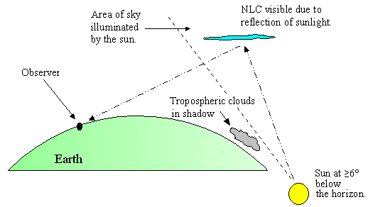