Tag Archive: Northern Hemisphere


Earth Watch Report Banner photo FSPEarthWatchReport900x228Blogger_zps53ef6af0.jpg

……………………………………………………………………………….


Accuweather

NASA: North Atlantic ‘Cold Blob’ May be Culprit Behind Ocean Current Slowdown

By Mark Leberfinger, AccuWeather.com Staff Writer
November 17, 2015; 12:34 AM ET

A major player in the transportation of heat in the Atlantic Ocean is slowing down and may affect higher latitude climates in the Northern Hemisphere, according to a NASA analysis of satellite data.

The “cold blob” that developed off Greenland may be the drag on the Atlantic Meridional Overturning Circulation (AMOC) by producing very chilly to record cold water, the National Oceanic and Atmospheric Administration (NOAA) said earlier this year.

Global warming may be responsible for AMOC’s slowdown but natural forces may also be at work, NASA said. AMOC is part of the complex circulation of currents that help take the warmer Gulf Stream water and move it through the basin.

Data from the Gravity Recovery and Climate Experiment (GRACE) satellites correspond with similar findings that were not satellite-based. The GRACE findings were published in the journal Geophysical Research Letters.

An AMOC slowdown would impact other currents throughout the Atlantic.


Read More Here

Earth Watch Report Banner photo FSPEarthWatchReport900x228Blogger_zps53ef6af0.jpg

 ……………………………………………………………………………….

New maps show how habitats may shift with climate change

This map shows how marine habitat ranges will shift likely in a segment of the Northern Hemisphere. The length of the black arrows indicates the velocity of temperature change, and the color schemes correspond with the nature of the habitat migration, as follows. SINK: Migrations terminate due to some barrier, such as coastlines. SOURCE: Migrations do not terminate. CORRIDOR: Many migrations passing through. DIVERGENCE: Fewer migrations end than start. CONVERGENCE: More migrations start than end. Credit: Michael Burrows and Jorge Garcia Molinosor (Credit: Michael Burrows and Jorge Garcia Molinosor)

This map shows how marine habitat ranges will shift likely in a segment of the Northern Hemisphere. The length of the black arrows indicates the velocity of temperature change, and the color schemes correspond with the nature of the habitat migration, as follows. SINK: Migrations terminate due to some barrier, such as coastlines. SOURCE: Migrations do not terminate. CORRIDOR: Many migrations passing through. DIVERGENCE: Fewer migrations end than start. CONVERGENCE: More migrations start than end. Credit: Michael Burrows and Jorge Garcia Molinosor

As regional temperatures shift with climate change, many plants and animals will need to relocate to make sure they stay in the range of temperatures they’re used to.

For some species, this shift will mean a fairly direct adjustment toward higher latitudes to stay with cooler temperatures, but for many others, the path will take twists and turns due to differences in the rate at which temperatures change around the world, scientists say.

Now, a team of 21 international researchers has identified potential paths of these twists and turns by mapping out climate velocities— the speed and intensity with which climate change occurs in a given region — averaged from 50 years of satellite data from 1960 through 2009, and projected for the duration of the 21st century.

MSN Weather: What causes global warming?
MSN Weather: How global warming can make cold snaps even worse

“We are taking physical data that we have had for a long time and representing them in a way that is more relevant to other disciplines, like ecology,” said co-author Michael Burrows, a researcher at the Scottish Marine Institute. “This is a relatively simple approach to understanding how climate is going to influence ocean and land systems.”

Where species come and go

The resulting maps indicate regions likely to experience an influx or exodus of new species, or behave as a corridor or, conversely, a barrier, to migration. Barriers, such as coastlines or mountain ranges, could cause local extinctions if they prevent species from relocating, the team says.  [Maps: Habitat Shifts Due to Climate Change]

“For example, because those environments are not adjacent to or directly connected to a warmer place, those species from warmer places won’t be able to get there very easily,” Burrows told Live Science. “They might still get there in other ways, like on the bottoms of ships, but they won’t get there as easily.”

Read More Here

Enhanced by Zemanta

BPEarthWatch BPEarthWatch·

Published on Dec 28, 2013

Reports of a large meteor over the San Diego Area.http://amsmeteors.org/members/firebal….
Live Show Today on Blogtalk http://www.blogtalkradio.com/bpearthw… and Livestreamhttp://new.livestream.com @ 12 noon central 1 pm Eastern.. Look under BPEARTHWATCH.

…..

Observing

The Quadrantid meteor shower is one of the strongest meteor showers of the year, but observers can be disappointed if conditions are not just right. The point from where the Quadrantid meteors appear to radiate is located within the extinct constellation Quadrans Muralis. On modern star charts, this radiant is located where the constellations Hercules, Boötes, and Draco meet in the sky. The shower can appear almost nonexistent until about 11 p.m. Unfortunately, the radiant does not attain a very high altitude for most Northern Hemisphere observers before morning twilight puts an end to the show. The best observations are actually possible from countries with high northern latitudes, such as Canada, Finland, Sweden, and Norway. The display is virtually nonexistent for observers in the Southern Hemisphere.

The Quadrantids generally begin on December 28 and end on January 7, with maximum generally occurring during the morning hours of January 3/4. The Quadrantids are barely detectable on the beginning and ending dates, but observers in the Northern Hemisphere can see from 10 to around 60 meteors per hour at maximum. The maximum only lasts for a few hours.

There are other, weaker meteor showers going on around the same time as the Quadrantids. The Quadrantids are medium-paced when compared to meteors from other meteor showers. When you see a meteor, mentally trace it backwards. If you end up where Hercules, Boötes, and Draco meet in the sky then you have probably seen a Quadrantid meteor! If you are not sure where the Quadrantid radiant is in the sky, the following chart will help you find it from the Northern Hemisphere:

Location of the Quadrantids
For Northern Hemisphere Observers

This represents the view from mid-northern latitudes at about 1:00 a.m. local time around January 4. The graphic does not represent the view at the time of maximum, but is simply meant to help prospective observers to find the radiant location. The red line across the bottom of the image represents the horizon. (Image produced by the Author using SkyChart III and Adobe Photoshop.)

Read More Here

…..

timcline.org

FIREBALL 12-26-2013….

The big Iowa fireball on 12-26-2013….

In the image below,,the fireball is the bright streak in the upper right corner,,just above the horizon….This would be north towards Des Moines….

meteor

meteor

Watch Video Here

…..

Spaceweather.com


All Sky Fireball Network

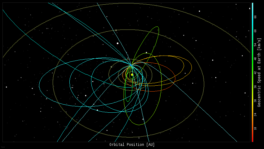
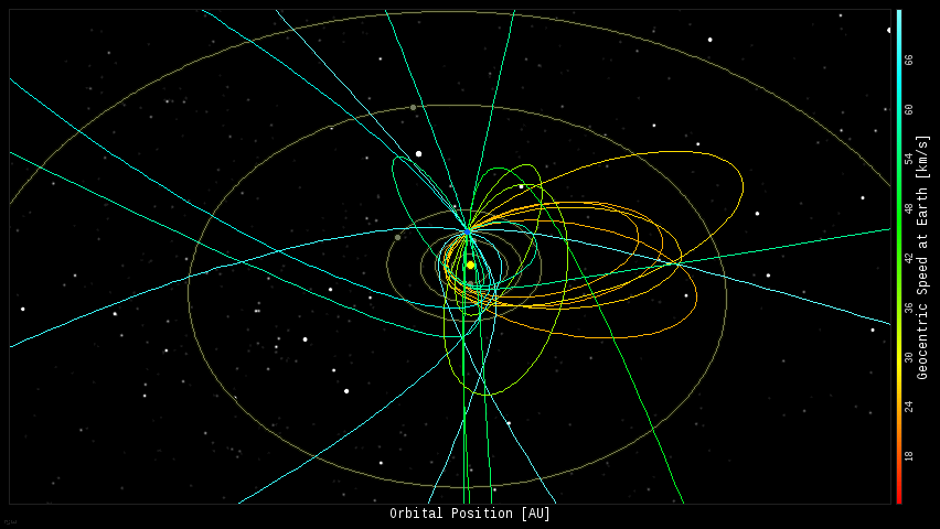
Every night, a network of NASA all-sky cameras scans the skies above the United States for meteoritic fireballs. Automated software maintained by NASA’s Meteoroid Environment Office calculates their orbits, velocity, penetration depth in Earth’s atmosphere and many other characteristics. Daily results are presented here on Spaceweather.com.

On Dec. 27, 2013, the network reported 16 fireballs.
(13 sporadics, 2 December Leonis Minorids, 1 December Hydrid)

In this diagram of the inner solar system, all of the fireball orbits intersect at a single point–Earth. The orbits are color-coded by velocity, from slow (red) to fast (blue). [Larger image] [movies]

On Dec. 26, 2013, the network reported 24 fireballs.
(21 sporadics, 3 December Leonis Minorids)

In this diagram of the inner solar system, all of the fireball orbits intersect at a single point–Earth. The orbits are color-coded by velocity, from slow (red) to fast (blue). [Larger image] [movies]


…..

Enhanced by Zemanta

EcoAlert: Changes in Earth’s Orbit Appear to be Key to Antarctic Warming

Antarctica-warming-660
Image Credit:  Adventure Journal

Analysis of an ice core taken by the National Science Foundation- (NSF) funded West Antarctic Ice Sheet (WAIS) Divide drilling project reveals that warming in Antarctica began about 22,000 years ago, a few thousand years earlier than suggested by previous records. This timing shows that West Antarctica did not “wait for a cue” from the Northern Hemisphere to start warming, as scientists had previously supposed.

For more than a century scientists have known that Earth’s ice ages are caused by the wobbling of the planet’s orbit, which changes its orientation to the sun and affects the amount of sunlight reaching higher latitudes.

The Northern Hemisphere’s last ice age ended about 20,000 years ago, and most evidence had indicated that the ice age in the Southern Hemisphere ended about 2,000 years later, suggesting that the South was responding to warming in the North.
But research published online Aug. 14 in the journal Nature shows that Antarctic warming began at least two, and perhaps four, millennia earlier than previously thought.

Most previous evidence for Antarctic climate change had come from ice cores drilled in East Antarctica, the highest and coldest part of the continent. However, a U.S.-led research team studying the West Antarctic core found that warming there was well underway 20,000 years ago.

WAIS Divide is a large-scale and multi-year glaciology project supported by the U.S. Antarctic Program (USAP), which NSF manages. Through USAP, NSF coordinates all U.S. science on the southernmost continent and aboard vessels in the Southern Ocean and provides the necessary logistics to make the science possible.


Read More Here

Enhanced by Zemanta

Science Daily


Feb. 25, 2013 — The world has suffered from severe regional weather extremes in recent years, such as the heat wave in the United States in 2011 or the one in Russia 2010 coinciding with the unprecedented Pakistan flood. Behind these devastating individual events there is a common physical cause, propose scientists of the Potsdam Institute for Climate Impact Research (PIK). The study will be published this week in the Proceedings of the National Academy of Sciences and suggests that man-made climate change repeatedly disturbs the patterns of atmospheric flow around the globe’s Northern hemisphere through a subtle resonance mechanism.


Meridional windfield over four different timespans. (Credit: Image courtesy of Potsdam Institute for Climate Impact Research (PIK))


“An important part of the global air motion in the mid-latitudes of the Earth normally takes the form of waves wandering around the planet, oscillating between the tropical and the Arctic regions. So when they swing up, these waves suck warm air from the tropics to Europe, Russia, or the US, and when they swing down, they do the same thing with cold air from the Arctic,” explains lead author Vladimir Petoukhov.

“What we found is that during several recent extreme weather events these planetary waves almost freeze in their tracks for weeks. So instead of bringing in cool air after having brought warm air in before, the heat just stays. In fact, we observe a strong amplification of the usually weak, slowly moving component of these waves,” says Petoukhov. Time is critical here: two or three days of 30 degrees Celsius are no problem, but twenty or more days lead to extreme heat stress. Since many ecosystems and cities are not adapted to this, prolonged hot periods can result in a high death toll, forest fires, and dramatic harvest losses.

Anomalous surface temperatures are disturbing the air flows….


Read Full Article Here

WHITE OUT

 
by Staff Writers
Paris (ESA)


Time series of Northern Hemisphere June snow cover (red), June sea-ice extent (black) and September sea-ice extent (grey). Thick lines denote five-year running mean. Relative to a 1979-2000 baseline, June snow cover – also known as ‘snow areal extent’ – has declined by 17.6%, whereas September sea-ice has declined by 13.0%. Credits: C. Derksen and R. Brown, Environment Canada (Data from the US National Snow and Ice Data Center and Rutgers University Global Snow Lab)

Santa Claus may someday need wheels for his sleigh – satellites show a decreasing amount of snow in the Northern Hemisphere. A new analysis of snow cover observed by satellites shows record lows in Eurasia for June each year since 2008. In addition, three of the past five years have seen record low cover in North America.

This is the lowest June snow extent since satellite observations began some 45 years ago. June snow cover is found to be falling much faster than expected from climate models, and is disappearing even quicker than summertime Arctic sea-ice.

These results, published in Geophysical Research Letters in October and based on snow chart data from the US National Oceanic and Atmospheric Administration (NOAA), are consistent with indications of a decline in monthly-average snow mass, published last year as part of ESA’s GlobSnow project.

The results show that the maximum amount of snow across the Northern Hemisphere is slowly falling, while spring snow – particularly at high latitudes – is melting significantly earlier.

GlobSnow produced a long time-series of snow mass from 1979 to 2012, as well as a time-series of snow cover from 1995 to 2012.