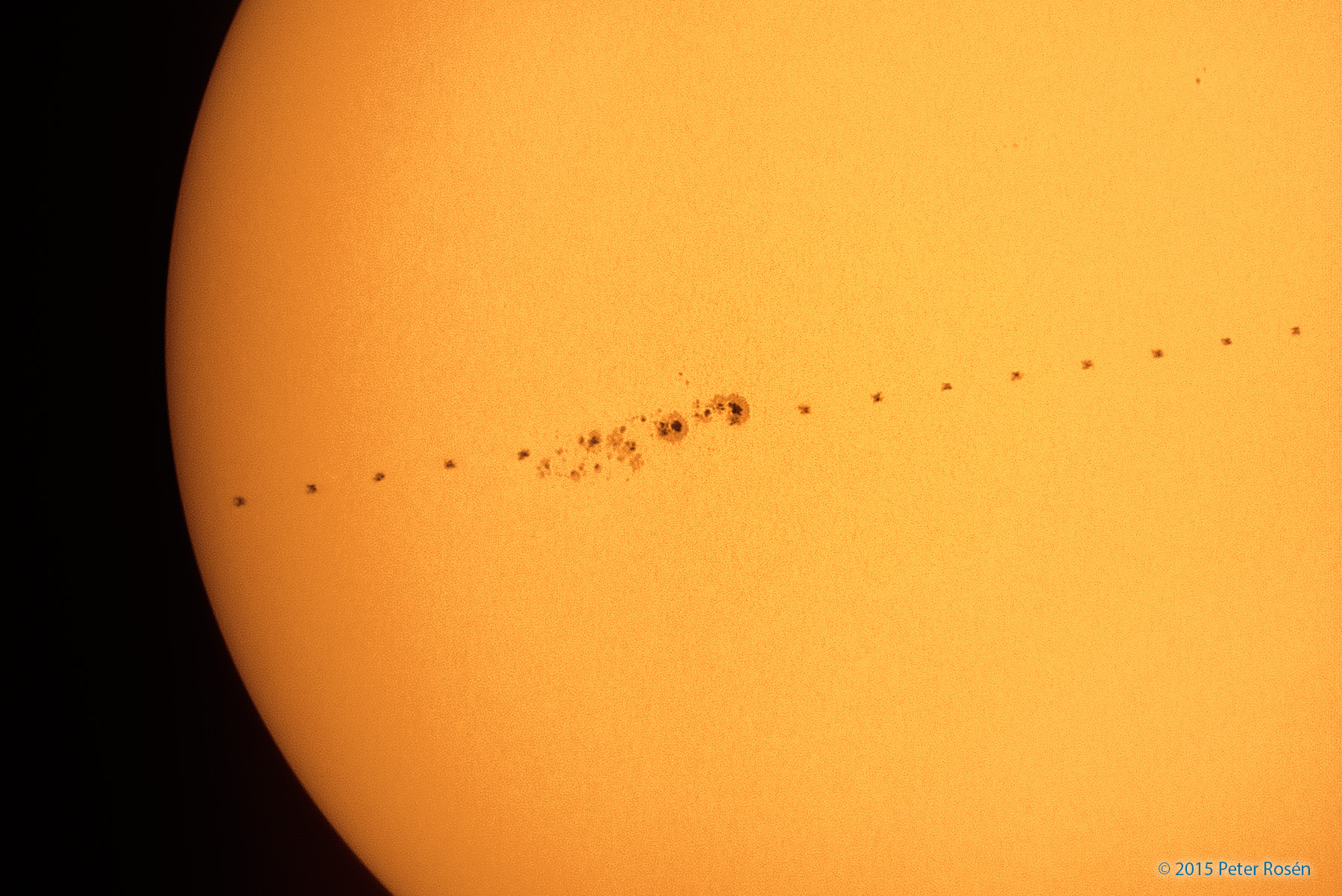
Sunspot AR2443 is so big, it is attracting the attention of astrophotographers around the world. Earlier today when Peter Rosén of Stockholm, Sweden, photographed the sprawling complex, he found a spaceship hiding among its dark cores. Seriously. Take a close look at the image below:
Can’t find the spaceship? Click here and here. “It is the International Space Station,” explains Rosén. “I caught it making a split-second transit of the giant sunspot.”
Indeed, AR244 is huge. From end to end it measures almost 200,000 km. Many of the dark cores are as large as terrestrial continents–and a couple are as large as Earth itself. These dimensions make it an easy target for backyard solartelecopes.
Of greater interest is the sunspot’s potential for explosive activity. The spotty complex has a ‘beta-gamma’ magnetic field that harbors energy for strong M-class solar flares. Any such explosions will be geoeffective as the sunspot turns squarely toward Earth in the days ahead.
Orbital Sciences Corp’s Antares rocket before its planned launch in Wallops Island, Virginia. Photograph: Bill Ingalls/Nasa/Getty Images
A strong solar storm is interfering with the latest grocery run to the International Space Station.
On the bright side, the orbiting lab has won a four-year extension, pushing its projected end-of-lifetime to at least 2024, a full decade from now.
“This is a big plus for us,” said Nasa’s human exploration chief, Bill Gerstenmaier.
On Wednesday, Orbital Sciences Corp delayed its space station delivery mission for the third time.
The company’s unmanned rocket, the Antares, was set to blast off from Wallops Island, Virginia, with a capsule full of supplies and science experiments, including ants for an educational project. But several hours before Wednesday afternoon’s planned flight, company officials took the unusual step of postponing the launch for fear solar radiation could doom the rocket.
Orbital Sciences’ chief technical officer, Antonio Elias, said solar particles might interfere with electronics equipment in the rocket, and lead to a launch failure.
Although the solar storm barely rated moderate, some passenger jets were being diverted from the poles to avoid potential communication and health issues. GPS devices also were at risk.
But the six men aboard the space station were safe from the solar fallout, Nasa said, and satellites also faced no threat. The Cygnus cargo ship aboard the rocket, for example, is built to withstand radiation from solar flare-ups.
Expedition 38 crew member Rick Mastracchio (L) checks out the spacesuit that he will wear during a spacewalk with crew member Mike Hopkins, in the Quest airlock in the International Space Station in this undated image taken from video from NASA TV, Dec. 20, 2013.
Reuters
December 23, 2013
CAPE CANAVERAL, FLORIDA — Astronauts aboard the International Space Station are planning a second and final spacewalk early Tuesday to fix the outpost’s cooling system, a NASA official said.
NASA astronauts Rick Mastracchio and Mike Hopkins are expected to leave the station’s Quest airlock to install a new ammonia pump, space station flight director Judd Frieling said during an interview on NASA Television on Monday.
During an initial spacewalk on Saturday, Mastracchio and Hopkins removed a failed pump, accomplishing about half the work planned for the second spacewalk. That prompted the National Aeronautics and Space Administration to drop plans for a third spacewalk, provided that no problems occur on Tuesday.
“It’s apparent now that we’ll be able to get most of our critical objectives done tomorrow [Tuesday],” said Frieling.
CAPE CANAVERAL, Fla. (AP) — NASA has ordered up a series of urgent spacewalks to fix a broken cooling line at the International Space Station, a massive repair job that could stretch to Christmas Day.
Station managers decided Tuesday to send two American astronauts out as soon as possible to replace a pump with a bad valve. The task will require two and possibly three spacewalks on Saturday, Monday and next Wednesday — Christmas Day.
“The next week will be busy with space walks so not much tweeting from here,” NASA astronaut Rick Mastracchio said from space via Twitter soon after the decision was announced.
The spacewalks are taking priority over the launch of a supply ship from Virginia. The commercial delivery had been scheduled for this week, but is now delayed until at least mid-January.
Officials stressed that the six occupants of the International Space Station were in no danger after the shutdown, and that the orbiting complex was in a stable situation.
CAPE CANAVERAL, Florida (AP) — Half of the International Space Station’s cooling system suddenly shut down during the weekend, forcing the astronauts to power down equipment and face the likelihood of urgent spacewalking repairs.
After huddling Sunday, NASA managers gave preliminary approval for a pair of spacewalks, the first of which would take place later this week. Two of the Americans on board were already scheduled to conduct a spacewalk Thursday for routine maintenance, though the repairs would supersede the original chores.
Officials stressed that the six occupants were in no danger, and that the orbiting complex was in a stable situation.
The trouble arose Saturday night, when one of the two ammonia-fed cooling loops shut down. Alarms sounded throughout the sprawling outpost as the circuit breaker for the pump in that line tripped, causing the pump to stop working.
The cooling system is critical for on-board operations. The two ammonia lines ensure that all the station’s electronic equipment does not overheat and with one of those out of commission, there is no safeguard in case of a second failure.
Astronaut Tracy Caldwell Dyson hustled through the equipment shutdown procedures and, with crewmate Douglas Wheelock, installed a jumper cable to keep all the rooms cool.
Russia may build its own space station with International Space Station (ISS) units after 2020 if the ISS partners choose not to extend the project and there is political will to do so, a source from the national space industry said on Monday.
“A new orbital station of Russia is under consideration. Apart from doing research, it will assemble interplanetary expedition complexes for missions to the Moon, Mars and Lagrangian points,” he said.
The Multirole Laboratory Module (MLM) is supposed to be connected to the ISS in 2014 although “the project has been experiencing certain problems,” he said.
“This is a landmark module for Russia’s manned program.”
“We will create a node unit with a service life of 30 years in 2014-2015. The MLM, two research and power modules, the node and, possibly, the ISS service module will make up a national orbital station to operate during the period from 2020 until 2040,” the source said.
“The prospective manned spaceship [on which the Energia Corporation is working] will have a trial unmanned mission by 2020,” he added.
European Space Agency
ESA’s XMM-Newton space telescope has helped to identify a star and a black hole that orbit each other at the dizzying rate of once every 2.4 hours, smashing the previous record by nearly an hour.The black hole in this compact pairing, known as MAXI J1659-152, is at least three times more massive than the Sun, while its red dwarf companion star has a mass only 20% that of the Sun. The pair is separated by roughly a million kilometres.The duo were discovered on 25 September 2010 by NASA’s Swift space telescope and were initially thought to be a gamma-ray burst. Later that day, Japan’s MAXI telescope on the International Space Station found a bright X-ray source at the same place.
More observations from ground and space telescopes, including XMM-Newton, revealed that the X-rays come from a black hole feeding off material ripped from a tiny companion.
Several regularly-spaced dips in the emission were seen in an uninterrupted 14.5 hour observation with XMM-Newton, caused by the uneven rim of the black hole’s accretion disc briefly obscuring the X-rays as the system rotates, its disc almost edge-on along XMM-Newton’s line of sight.
From these dips, an orbital period of just 2.4 hours was measured, setting a new record for black hole X-ray binary systems. The previous record-holder, Swift J1753.5–0127, has a period of 3.2 hours.
The black hole and the star orbit their common centre of mass. Because the star is the lighter object, it lies further from this point and has to travel around its larger orbit at a breakneck speed of two million kilometres per hour – it is the fastest moving star ever seen in an X-ray binary system. On the other hand, the black hole orbits at ‘only’ 150 000 km/h.
“The companion star revolves around the common centre of mass at a dizzying rate, almost 20 times faster than Earth orbits the Sun. You really wouldn’t like to be on such a merry-go-round in this Galactic fair!” says lead author Erik Kuulkers of ESA’s European Space Astronomy Centre in Spain.
His team also saw that they lie high above the Galactic plane, out of the main disc of our spiral Galaxy, an unusual characteristic shared only by two other black-hole binary systems, including Swift J1753.5–0127.
“These high galactic latitude locations and short orbital periods are signatures of a potential new class of binary system, objects that may have been kicked out of the Galactic plane during the explosive formation of the black hole itself,” says Dr Kuulkers.
Returning to MAXI J1659−152, the quick response of XMM-Newton was key in being able to measure the remarkably short orbital period of the system.
“Observations started at tea-time, just five hours after we received the request to begin taking measurements, and continued until breakfast the next day. Without this rapid response it would not have been possible to discover the fastest rotation yet known for any binary system with a black hole,” adds Norbert Schartel, ESA’s XMM-Newton project scientist.
A black hole is formed when a star implodes with enough force to overcome the nuclear strong force. If the neutron core of a supernova is greater than about 2 solar masses, the core will collapse into a black hole.
Structure of a black hole:
-The photon sphere traps light particles in orbit around the black hole
-Inside the event horizon light particles cannot escape
-The event horizon’s diameter is 6 km for every 1 solar mass the black hole contains
– Gravitational lensing of background stars occurs out to a distance twice the radius of the event horizon
X-ray binaries may be black holes pulling material from their companion stars. Cygnus X-1 may be a binary star pair containing a black hole.
Gravitation waves from black holes may be detectable and may tell us about the processes occurring during the birth of a black hole.
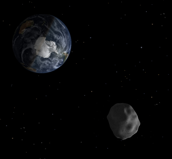
Asteroid 2012 DA14 Zooms just 17,200 miles above Earth on Feb. 15, 2013 in this artist’s concept: Credit: NASA/JPL
Our home planet is due for a record setting space encounter on Friday (Feb. 15) of this week, when a space rock roughly half a football field wide skirts very close by Earth at break neck speed and well inside the plethora of hugely expensive communications and weather satellites that ring around us in geosynchronous orbit.
“There is no possibility of an Earth impact” by the Near Earth Asteroid (NEO) known as 2012 DA 14, said Don Yeomans, NASA’s foremost asteroid expert at a media briefing. Well that’s good news for us – but a little late for the dinosaurs.
At its closest approach in less than 4 days, the 45 meter (150 feet) wide Asteroid 2012 DA14 will zoom by within an altitude of 27,700 kilometers (17,200 miles). That is some 8000 km (5000 miles) inside the ring of geosynchronous satellites, but far above most Earth orbiting satellites, including the 6 person crew currently working aboard the International Space Station.
Although the likelihood of a satellite collision is extremely remote, NASA is actively working with satellite providers to inform them of the space rocks path.
The razor thin close shave takes place at about 2:24 p.m. EST (11:24 a.m. PST and 1924 UTC) as the asteroid passes swiftly by at a speed of about 7.8 kilometers per second (17,400 MPH)- or about 8 times the speed of a rifle bullet. For some perspective, it will be only about 1/13th of the distance to the moon at its closest.
“Asteroid 2012 DA14 will make a very close Earth approach, traveling rapidly from South to North and be moving at about two full moons per minute,” said Yeomans, who manages NASA’s Near-Earth Object Program Office at the Jet Propulsion Laboratory in Pasadena, Calif. “That’s very fast for a celestial object.”
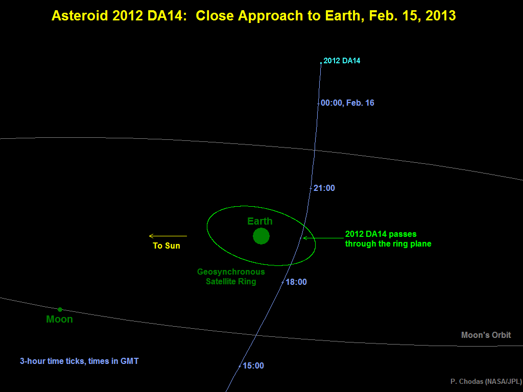
Diagram depicting the passage of asteroid 2012 DA14 through the Earth-moon system on Feb. 15, 2013. Credit: NASA/JPL-Caltech
No known asteroid has ever passed so near to Earth.
“This is a record predicted close approach for a known object this size,” stated Yeomans. “Such close flybys happen every 40 years on average. An actual Earth collision would happen about every 1200 years.”
Even though 2012 DA14 is coming remarkably close, it will still only appear as a point of light in the biggest of optical telescopes, because of its small size. Based on its brightness, astronomers estimate that it is only about 45 meters (150 feet) across. It will brighten only to magnitude 7.5, too faint to be seen with the naked eye, but easily visible with a good set of binoculars or a small telescope. The best viewing location for the closest approach will be Indonesia, from which the asteroid will be seen to move at a rate of almost 1 degree per minute against the star background. Eastern Europe, Asia and Australia are also well situated to see the asteroid around its closest approach.
The small near-Earth asteroid 2012 DA14 will pass very close to Earth on February 15, so close that it will pass inside the ring of geosynchronous weather and communications satellites.
NASA’s Near-Earth Object Program Office can accurately predict the asteroid’s path with the observations obtained, and it is therefore known that there is no chance that the asteroid might be on a collision course with Earth. Nevertheless, the flyby will provide a unique opportunity for researchers to study a near-Earth object up close.
Asteroid 2012 DA14 will be closest to Earth on Feb. 15, at about 11:24 p.m. PST (2 p.m. EST and 1924 UT), when it will be at a distance of about 27,700 kilometers (17,200 miles) above Earth’s surface.
Although this is close enough for the asteroid to pass inside the ring of geosynchronous satellites, located about 35,800 kilometers (22,200 miles) above the equator, it will still be well above the vast majority of satellites, including the International Space Station.
A look at how geologists are keeping an eye on California’s 800 mile-long San Andreas Fault which many believe is overdue for a major earthquake in the region that could destroy some of the most valuable real-estate in the world.
It’s beginning to look a lot like mid-summer, and it’s still May. Not good for farm fields or your lawn. Demand for water in Indianapolis is up 20 million gallons this week alone. And the heat is just beginning.
(Reuters) – Firefighters managed to protect the remaining homes in a southwestern New Mexico subdivision overnight, but some outlying buildings were engulfed by flames from a fire that burned on rough mountain terrain near the Arizona border.
Two fires merged in the Gila National Forest on Thursday and consumed 12,000 additional acres overnight, bringing the total burn area to 82,252 acres with none of it contained, said Public Information Officer Iris Estes.
Estes said firefighters were able to build fire lines toward the north, and expected gusty winds of 15 to 28 miles per hour to move the flames in that direction by midday.
Efforts overnight managed to preserve the more than 45 remaining vacation homes in the area. A total of twelve homes and 13 outlying buildings have been destroyed so far, Estes said.
“The fire is still burning in the subdivision, but they did a good job of getting in there and getting some structure protection in there,” Estes said.
Estes said the fire “spread out and moved in all directions” as it burned late Thursday, which allowed firefighters to get closer to the blaze and build fire lines with bulldozers.
“It didn’t make a run in any one direction, so we’re hoping it will continue to do that today,” she said.
More than 500 people are currently fighting the blaze. Voluntary evacuations were in effect for the nearby town of Mogollon.
May 26 (Reuters) – Subtropical Storm Beryl churned toward the U.S. southeast coast on Saturday, threatening heavy rains and dangerous surf on Sunday to northeastern Florida, Georgia and South Carolina, the U.S. National Hurricane Center said.
Beryl was centered about 230 miles (375 km) east-southeast of Charleston, South Carolina, carrying maximum sustained winds of 45 mph (75 kph). It was moving southwest with tropical storm force winds extending about 115 miles (185 km) from the storm’s center.
Tropical storm warnings were in effect for Sunday from the Volusia/Brevard County line in northern Florida to Edisto Beach, South Carolina.
Forecasters predict the storm will eventually turn back toward the Atlantic on Monday or Tuesday, posing no threat to oil and gas production facilities in the U.S. Gulf of Mexico.
The hurricane center said dangerous surf conditions and unusually high tides are possible along the coasts of northern Florida, Georgia and South Carolina over the Memorial Day weekend.
Beryl is being called a subtropical storm, which usually have a broader wind field than tropical storms and shower and thunderstorm activity farther removed from the storm’s center.
Beryl formed off the South Carolina coast late on Friday and is the second named storm of the Atlantic hurricane season, which has had an early start. The season officially runs from June 1 to Nov. 30. (Reporting by Kevin Gray; Editing by Vicki Allen)
Tokyo soil so contaminated with radiation it would be considered nuclear waste in US
By Ethan A. Huff,
(NaturalNews) Radioactive fallout from the Fukushima Daiichi nuclear disaster continues to show up at dangerously high levels in the city of Tokyo, which is located roughly 200 miles from the actual disaster site. According to an analysis of five random soil samples recently taken by nuclear expert Arnie Gundersen, the soil around Tokyo is so contaminated with Fukushima radiation that it would be considered nuclear waste here in the U.S.
During a recent trip to Tokyo, Gundersen collected soil samples from a sidewalk, a children’s playground, a rooftop, a patch of moss by the side of a road, and the lawn of a judicial building. After sending those samples in for testing, it was revealed that each one had high levels of radioactive cesium-134 (CS134) and cesium-137 (CS137), while three of the samples contained high levels of cobalt-60 (CO60). One of the samples also tested positive for uranium-235 (U235).
“[W]hen I was in Tokyo, I took some samples […] and sent them to the lab,” said Gundersen in a recent video report. “And the lab determined that all of them would be qualified as radioactive waste here in the United States and would have to be shipped to Texas to be disposed of.”
Despite the fact that radioactive plumes from Fukushima have largely drifted seaward based on wind patterns, a considerable amount of this radiation traveled southward towards Tokyo and elsewhere. The findings also confirm the reality that Fukushima radiation has likely had significant global spread as well, which confirms earlier reports of samples taken on the U.S. West Coast (http://www.naturalnews.com/035731_Fukushima_radiation_America.html).
Analysis of Solar Active Regions and Activity from 24/2100Z
to 25/2100Z: Solar activity was low. A few nominal C-class flares
occurred. Two new active Regions, 1491 (N23W29) and 1492 (S13E65)
were numbered today. A few CMEs were observed during the period,
but all appear to be limb events and non-geoeffective.
The next Venus transit across the sun won’t occur until December 2117.
By Mike Wall, SPACE.com
SLOW MOVE: Watching the tiny silhouette of the planet Venus slowly cross the face of the sun (here in 2004) doesn’t evoke the same drama and excitement as experiencing a total solar eclipse. (Photo: Imelda B. Joson and Edwin L. Aguirre)
A NASA sun-watching spacecraft will have an unbeatable view of June’s historic Venus transit, but some of the probe’s scientists are taking measures to get a great look for themselves here on Earth, too.
NASA’s Solar Dynamics Observatory (SDO) satellite will watch from space as Venus crosses the sun’s face on June 5 (June 6 in the Eastern Hemisphere) — the last such Venus transit until December 2117. Not content to live vicariously through their spacecraft, some SDO scientists are headed to Alaska to watch the seven-hour event in its entirety.
“For the United States, only Hawaii and Alaska will see the entire transit,” said SDO project scientist Dean Pesnell, of NASA’s Goddard Space Flight Center in Greenbelt, Md. “There’s a solar physics meeting in Anchorage, Alaska, the week after the transit. So we said, ‘Well, let’s go to Alaska and see the transit.'”
Venus transits occur in pairs that are eight years apart, but these dual events take place less than once per century. The last transit happened in 2004, and the next won’t come until 2117. So next month’s transit is the last chance for skywatchers to see Earth’s so-called sister planet trek across the solar disk. [Venus Transit of 2004: 51 Amazing Photos]
Venus transits have played a large role in astronomical history. Scientists and explorers, for example, mounted large expeditions to observe the 18th century’s two transits, which occurred in 1761 and 1769.
The idea was to time the Venus transit precisely from many different spots around the globe, then use the principle of parallax to calculate the distance from Earth to the sun — a quantity that had eluded scientists for millenia. With that information in hand, the scale of the entire solar system would follow.
The 1761 and 1769 efforts both came up short, but measurements made with the help of photographs during the 19th century’s Venus transits finally gave researchers the data they needed.
For its part, SDO will observe the transit to learn more about Venus’ atmosphere and to help calibrate some of its instruments, Pesnell said.
An outreach opportunity
Pesnell and his colleagues plan to watch the transit from Fairbanks, and they’re going to use the rare event as an education and outreach opportunity.
“We’re working with some amateur astronomers up there to set up a family science-oriented event in the city of Fairbanks,” Pesnell told SPACE.com, adding that the team will bring 10 to 20 different displays to teach people about the sun and SDO. “It’s been a fairly popular thing to take to cities.”
Those of us unable to make the trek to Alaska, Hawaii or other good transit-viewing locales around the world will still be able to watch the historic event as it happens. Pesnell said that NASA plans to webcast live footage of the transit from SDO, whose images should be spectacular.
“There are no clouds in space, so we’re guaranteed to have a pretty good view,” Pesnell said.
The $850 million SDO spacecraft launched in February 2010. The probe’s five-year mission is the cornerstone of a NASA science program called Living with a Star, which aims to help researchers better understand aspects of the sun-Earth system that affect our lives and society.
You can follow SPACE.com senior writer Mike Wall on Twitter: @michaeldwall. Follow SPACE.com for the latest in space science and exploration news on Twitter @Spacedotcom and on Facebook.
UPCOMING CLOSE APPROACHES TO EARTH
1 AU = ~150 million kilometers
1 LD = Lunar Distance = ~384,000 kilometers
A dead dolphin lying on a beach on the northern coast of Peru, close to Chiclayo, some 750 km north of Lima, in March 2012. Thousands of crustaceans were found dead off the coast of Lima following the mystery mass death of dolphins and pelicans, the Peruvian Navy said Friday
Thousands of crustaceans were found dead off the coast of Lima following the mystery mass death of dolphins and pelicans, the Peruvian Navy said Friday.
The cause of death is under investigation, said Industry and Fishing Minister Gladys Triveno, warning that “it would be premature to give a reason for this phenomenon.”
The Navy said it presented a report on the find to the Agency of Environmental Evaluation and Control to determine the cause.
Biologist Yuri Hooker of Cayetano Heredia University said the species found on Pucusana Beach, 60 kilometers (37 miles) south of Lima, was a type of red krill about three centimeters (1.2 inches) long.
“They live mostly along the coast of Chile up to the coast of northern Peru. What is happening is that these crustaceans are being affected by the warming of Pacific waters in the north of the country,” he said, adding that the phenomenon occurs “with some frequency.”
Hooker explained that the warmer temperatures led the shrimp-like creatures that usually live far away from the coast to move in closer to land, where they died.
Nearly 900 dolphins washed up along Peru’s northern coast between February and April. A government study said the marine mammals died of natural causes, while environmental groups insist the massive toll was linked to offshore oil exploration in the area.
Peruvian officials have suggested that the dolphins, along with 5,000 dead sea birds — mostly pelicans — died due to the effects of rising temperatures in Pacific waters, including the southern migration of fish eaten by the birds.
Hardly a day goes by in Sochi, Russia’s picturesque Black Sea resort, without a dead dolphin washing up on the beach.
With the tourist season just kicking off, the unexplained deaths have yet to draw much scrutiny.
But environmentalists are increasingly alarmed. The dolphin carcasses are also turning into a real holiday spoiler for vacationers drawn to the region’s scenic beaches and pristine vistas.
Russian tourist Aida Kobzh was shocked to discover a group of dead dolphins last week at her local beach in Sochi.
“Everyone stood there and stared at the dead little dolphins lying belly up. Poor creatures!” Kobzh says. “There were some on the beach but also in the water, they were floating there, dead.
Little Official Interest
The dolphins started washing up along Russia’s Black Sea coast several weeks ago. They have also been spotted on Ukrainian shores.
Environmentalists are now talking about the biggest dolphin die-off to date in the region, with an estimated 300 animals dead so far.
Local authorities have made no serious attempt to investigate the deaths, saying the animals are too decayed by the time they reach the shore for laboratory tests to be conducted.
Officials have blamed poachers and fishing nets. They say the unusually cold winter has driven dolphins from the Sea of Azov to the warmer Black Sea.
Some experts, like local zoologist Konstantin Andramonov, point to a possible killer virus.
“The death toll is constantly growing, unfortunately,” Andramonov says. “We are now witnessing the same in Ukraine. There is a hypothesis that we are dealing with an infectious disease that occurs roughly every 20 years.”
Ecosystem In Danger
Most experts, however, believe the real culprit is ever-increasing pollution in the Black Sea region.
Valery Brinikh, who works for the prominent environmental group Ecological Watch, says the scale of the dolphin deaths belies official accounts faulting poachers and fishing nets.
“This happens every year in Sochi — sometimes there are more deaths, sometimes fewer,” Brinikh says. “But the scale this time suggests unnatural causes, probably sea pollution or a loss of orientation of the dolphins, which can also be linked to pollution.”
Environmentalists say pollution levels have risen dramatically around Sochi since the city was selected to host the 2014 Winter Olympic Games.
They have long warned that unbridled construction is inflicting irreparable ecological damage to Sochi’s unique ecosystem.
Olga Noskovets, a local ecologist, suspects that the authorities are perfectly aware it is pollution that is killing the dolphins.
She says pollution levels are highest in areas close to the Olympic construction sites that dot Sochi and its outskirts.
Black-And-Blue Sea
According to Noskovets, the most affected area is Sochi’s Lazarevsky district, where tourist Aida Kobzh recently spotted the dead dolphins.
“The biggest hazard is posed by a river that runs through the Lazarevsky district, an area with a high concentration of sanatoriums, including for children,” says Noskovets. “The infamous Olympic dump lies nearby, and it has no waste-treatment system. This small mountain stream, which used to have fish, is now cloudy, brown and foamy. It collects waste and carries it to beaches that once counted among the most beautiful in the area.”
Noskovets says the dolphin die-off should act as a wake-up call. She says the authorities must urgently sound the alarm and warn visitors about the health hazards of bathing on certain Black Sea beaches before the tourist season reaches its peak.
“If sea creatures that are adapted to life in the sea react this way, what will the consequences be for humans?” Noskovets says. “Every year, numerous people suffer poisoning incidents after bathing in the sea, and these are always blamed on food poisoning. It is a nasty lie from our authorities, who are afraid of telling the truth — that the Black Sea is simply being poisoned.”
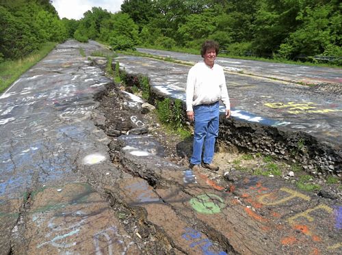
David DeKok, author of “Fire Underground,” a book about the town, poses Thursday on abandoned Route 61 in Centralia, Columbia County.
By Michael Rubinkam / The Associated Press
CENTRALIA, Pa. — It’s an anniversary the few remaining souls who live here won’t be celebrating.
Fifty years ago on Sunday, a fire at the town dump ignited an exposed coal seam and still burns today. It set off a chain of events that eventually led to the demolition of nearly every building in Centralia — a whole community of 1,400 simply gone.
All these decades later, the Centralia fire maintains its grip on the popular imagination, drawing visitors from around the world who come to gawk at twisted, buckled Route 61, at the sulfurous steam rising intermittently from ground that’s warm to the touch, at the empty, lonely streets where nature has reclaimed what coal-industry money once built. It’s a macabre story that has long provided fodder for books, movies and plays — the latest one debuting in March at a theater in New York.
Yet to the handful of residents who still occupy Centralia, who keep their houses tidy and their lawns mowed, this borough in the mountains of northeastern Pennsylvania is no sideshow attraction. It’s home, and they’d like to keep it that way.
“That’s all anybody wanted from day one,” said Tom Hynoski, who’s among the plaintiffs in a federal civil rights lawsuit aimed at blocking the state of Pennsylvania from evicting them.
Centralia was already a coal-mining town in decline when the fire department set the town’s landfill ablaze on May 27, 1962, in an ill-fated attempt to tidy up for Memorial Day. The fire wound up igniting the coal outcropping and, over the years, spread to the vast network of mines beneath homes and businesses, threatening residents with poisonous gases and dangerous sinkholes.
After a contentious battle over the future of the town, the side that wanted to evacuate won out. By the end of the 1980s, more than 1,000 people had moved and 500 structures were demolished under a $42 million federal relocation program.
But some holdouts refused to go — even after their houses were seized through eminent domain in the early 1990s. They said the fire posed little danger to their part of town, accused government officials and mining companies of a plot to grab the rights to billions of dollars’ worth of anthracite coal, and vowed to stay put.
After years of letting them be, state officials decided a few years ago to take possession of the homes. The state Department of Community and Economic Development said Friday it’s in negotiations with one of the five remaining homeowners; the others are continuing to resist, pleading their case in federal court.
Residents say the state has better things to spend its money on. A handwritten sign along the road blasts Gov. Tom Corbett, the latest chief executive to inherit a mess that goes back decades.
“You and your staff are making budget cuts everywhere,” the sign says. “How can you allow [the state] to waste money trying to force these residents out of their homes? These people want to pay their taxes and be left alone and live where they choose!”
Whether it’s safe to live there is subject to debate.
Tim Altares, a geologist with the Pennsylvania Department of Environmental Protection, said that while temperatures in monitoring boreholes are down — possibly indicating the fire has followed the coal seam deeper underground — the blaze still poses a threat because it has the potential to open up new paths for deadly gases to reach the remaining homes.
“It’s very difficult to quantify the threat, but the major threat would be infiltration of the fire gases into the confined space of a residential living area. That was true from the very beginning and will remain true even after the fire moves out of the area,” Mr. Alteres said.
Nonsense, say residents who point out they’ve lived for decades without incident.
Carl Womer, 88, whose late wife, Helen, was the leader of a faction that fiercely resisted the government buyout, disagrees the fire poses any threat.
“What mine fire?” Mr. Womer asked dismissively as he hosed down his front porch, preparing, he said, for a Memorial Day picnic. “If you go up and see a fire, you come back and tell me.”
Author and journalist David DeKok, who has been writing about Centralia for more than 30 years, said that while he believes Mr. Womer’s house is too close to the fire to safely live there, Mr. Hynoski and his neighbors are far enough away.
“I don’t think there’s any great public safety problem in letting those people stay there,” said Mr. DeKok, author of “Fire Underground,” a book on the town.
Many former residents, meanwhile, prefer to talk about the good times, their nostalgia taking on a decidedly golden hue.
“I loved it. I always liked Centralia from the time I was old enough to understand what it was,” said Mary Chapman, 72, who left in 1986 but returns once a month to the social club at the Centralia fire company.
“If you came out of your house and you couldn’t get your car started, the neighbor would come out and he’d help you. You didn’t even have to ask,” Ms. Chapman continued. “Of course the neighbors knew your business, but they also were there to help you, too.”
[In accordance with Title 17 U.S.C. Section 107, this material is distributed without profit, for research and/or educational purposes. This constitutes ‘FAIR USE’ of any such copyrighted material.]
The Hunger Site – Your click helps to feed the hungry
Wheatgrass Kits.com
FAIR USE NOTICE
The material on this site is provided for educational and informational purposes. It may contain copyrighted material the use of which has not always been specifically authorized by the copyright owner. It is being made available in an effort to advance the understanding of scientific, environmental, economic, social justice and human rights issues etc. It is believed that this constitutes a 'fair use' of any such copyrighted material as provided for in section 107 of the US Copyright Law. In accordance with Title 17 U.S.C. Section 107, the material on this site is distributed without profit to those who have an interest in using the included information for research and educational purposes. If you wish to use copyrighted material from this site for purposes of your own that go beyond 'fair use', you must obtain permission from the copyright owner. The information on this site does not constitute legal or technical advice.
Any materials (ie. graphics, articles , commentary) that are original to this blog are copyrighted and signed by it's creator. Said original material may be shared with attribution. Please respect the work that goes into these items and give the creator his/her credit. Just as we share articles , graphics and photos always giving credit to their creators when available. Credit and a link back to the original source is required.
If you have an issue with anything posted here or would prefer we not use it . Please contact me. Any items that are requested to be removed by the copyright owner will be removed immediately. No threats needed or lawsuit required. If there is a problem and you do not wish your work to be showcased then we will happily find an alternative from the many sources readily available from creators who would find it amenable to having their work presented to the subscribers of this feed.
Thank you for your time and attention, blessings to all :)


By MARCIA DUNN 12/17/13 06:32 PM ET EST