Earthquakes
RSOE EDIS
| Date/Time (UTC) | Magnitude | Area | Country | State/Prov./Gov. | Location | Risk | Source | Details | ||
| 27.05.2012 10:25:28 | 4.9 | Asia | Japan | Erimo | EMSC | |||||
| 27.05.2012 10:50:41 | 4.8 | Asia | Japan | Hokkaido | Erimo | USGS-RSOE | ||||
| 27.05.2012 10:25:49 | 2.2 | Europe | Italy | Crevalcore | EMSC | |||||
| 27.05.2012 10:00:25 | 4.3 | Caribbean | U.S. Virgin Islands | Bovoni | USGS-RSOE | |||||
| 27.05.2012 10:26:09 | 4.3 | Caribbean Sea | U.S. Virgin Islands | Bovoni | EMSC | |||||
| 27.05.2012 10:40:39 | 4.3 | Caribean | U.S. Virgin Islands | Bovoni | USGS-RSOE | |||||
| 27.05.2012 09:50:36 | 4.4 | Caribean | U.S. Virgin Islands | Nazareth | USGS-RSOE | |||||
| 27.05.2012 09:15:35 | 2.7 | North America | United States | Alaska | Beluga | USGS-RSOE | ||||
| 27.05.2012 09:20:29 | 2.9 | Asia | Turkey | Alacak | EMSC | |||||
| 27.05.2012 09:20:54 | 2.9 | Europe | Greece | Kattavia | EMSC | |||||
| 27.05.2012 09:21:12 | 3.1 | Europe | Italy | Scortichino | EMSC | |||||
| 27.05.2012 09:45:31 | 2.5 | Caribbean | Puerto Rico | Corcega | USGS-RSOE | |||||
| 27.05.2012 08:20:29 | 2.7 | Europe | Greece | Megalon Livadhion | EMSC | |||||
| 27.05.2012 08:20:50 | 3.5 | Europe | Romania | Bradetu | EMSC | |||||
| 27.05.2012 08:21:10 | 2.0 | Asia | Turkey | Karaca | EMSC | |||||
| 27.05.2012 08:21:30 | 2.9 | Europe | Italy | Ghisione | EMSC | |||||
| 27.05.2012 08:21:48 | 2.1 | Europe | Italy | La Pettenella | EMSC | |||||
| 27.05.2012 07:45:36 | 2.0 | North America | United States | Alaska | Yakutat | USGS-RSOE | ||||
| 27.05.2012 08:22:10 | 3.0 | Asia | Turkey | Alakilise | EMSC | |||||
| 27.05.2012 08:22:29 | 2.2 | Europe | Italy | Il Motto | EMSC | |||||
| 27.05.2012 08:22:51 | 4.6 | South-America | Peru | Nunez | EMSC | |||||
| 27.05.2012 07:40:35 | 4.7 | South America | Peru | Departamento de Ica | San Clemente | USGS-RSOE | ||||
| 27.05.2012 08:23:12 | 2.8 | Asia | Turkey | Inlice | EMSC | |||||
| 27.05.2012 08:30:30 | 3.1 | Caribbean | Puerto Rico | Jose P H Hernandez (subdivision) | USGS-RSOE | |||||
| 27.05.2012 07:22:17 | 3.1 | Pacific Ocean | New Zealand | Sumner | GEONET | |||||
| 27.05.2012 06:55:28 | 2.7 | North America | United States | California | Indio Hills | USGS-RSOE | ||||
| 27.05.2012 07:20:30 | 2.7 | Europe | Italy | Bellariva | EMSC | |||||
| 27.05.2012 07:20:51 | 2.6 | Europe | Italy | La Pettenella | EMSC | |||||
| 27.05.2012 06:10:29 | 5.3 | Indonesian archipelago | Indonesia | Seai | USGS-RSOE | |||||
| 27.05.2012 06:15:35 | 5.3 | Indonesian Archipelago | Indonesia | Bulatmonga | EMSC | |||||
| 27.05.2012 05:47:20 | 2.2 | North America | United States | California | Whitmore Hot Springs | USGS-RSOE | ||||
| 27.05.2012 06:15:56 | 2.5 | Europe | Greece | Nafpaktos | EMSC | |||||
| 27.05.2012 06:05:29 | 2.9 | Caribbean | Puerto Rico | Aguacate | USGS-RSOE | |||||
| 27.05.2012 05:48:19 | 4.3 | Europe | Sweden | (( Skaraborgs Lan )) | Vastbacken | USGS-RSOE | ||||
| 27.05.2012 06:16:19 | 4.2 | Europe | Sweden | Vastbacken | EMSC | |||||
| 27.05.2012 06:16:40 | 2.2 | Europe | Italy | Ponte Trevisani | EMSC | |||||
| 27.05.2012 06:17:01 | 2.8 | Asia | Turkey | Bekdemir | EMSC | |||||
| 27.05.2012 06:17:22 | 2.1 | Europe | Italy | Casa Novara | EMSC | |||||
| 27.05.2012 06:17:43 | 2.2 | Europe | Italy | Mirabello | EMSC | |||||
| 27.05.2012 06:18:04 | 2.0 | Europe | Italy | La Pettenella | EMSC | |||||
| 27.05.2012 05:15:29 | 3.2 | Europe | Italy | Stellata | EMSC | |||||
| 27.05.2012 05:15:52 | 2.3 | Europe | Italy | Finale Emilia | EMSC | |||||
| 27.05.2012 05:16:16 | 2.2 | Europe | Italy | La Massara | EMSC | |||||
| 27.05.2012 05:16:37 | 2.7 | Europe | Italy | La Massara | EMSC | |||||
| 27.05.2012 04:15:23 | 2.2 | Europe | Italy | Finale Emilia | EMSC | |||||
| 27.05.2012 05:16:59 | 2.4 | Asia | Turkey | Agarti | EMSC | |||||
| 27.05.2012 04:10:26 | 2.0 | North America | United States | Alaska | Kantishna | USGS-RSOE | ||||
| 27.05.2012 04:10:47 | 4.4 | Asia | Japan | Iwate-ken | Sasu | USGS-RSOE | ||||
| 27.05.2012 04:15:42 | 4.4 | Asia | Japan | Sasu | EMSC | |||||
| 27.05.2012 04:40:31 | 2.7 | Caribbean | British Virgin Islands | Belle Vue | USGS-RSOE | |||||
| 27.05.2012 04:16:03 | 2.4 | Europe | Italy | Chiusa | EMSC | |||||
| 27.05.2012 05:17:19 | 2.3 | Asia | Turkey | Karliyamac | EMSC | |||||
| 27.05.2012 04:16:30 | 2.3 | Europe | Italy | San Giacomo Roncole | EMSC | |||||
| 27.05.2012 03:11:39 | 2.2 | Europe | Italy | Pollara | EMSC | |||||
| 27.05.2012 02:55:26 | 2.2 | North America | United States | California | Desert Sands Mobile Home Park | USGS-RSOE | ||||
| 27.05.2012 03:12:00 | 2.3 | Europe | Italy | Gavello | EMSC | |||||
| 27.05.2012 03:12:21 | 2.8 | Europe | Greece | Mikroulaiika | EMSC | |||||
| 27.05.2012 03:12:41 | 2.9 | Asia | Turkey | Alakilise | EMSC | |||||
| 27.05.2012 03:25:30 | 2.4 | North America | United States | Alaska | Akutan | USGS-RSOE | ||||
| 27.05.2012 03:13:02 | 2.7 | Europe | Italy | Quarantoli | EMSC | |||||
| 27.05.2012 03:40:28 | 3.1 | Caribbean | Puerto Rico | Soroco | USGS-RSOE | |||||
| 27.05.2012 02:10:24 | 2.0 | Europe | Italy | Castrovillari | EMSC | |||||
| 27.05.2012 02:10:44 | 2.3 | Asia | Turkey | Korucuk | EMSC | |||||
| 27.05.2012 02:11:05 | 2.5 | Europe | Greece | Schoinas | EMSC | |||||
| 27.05.2012 02:11:26 | 2.5 | Europe | Italy | San Nicola | EMSC | |||||
| 27.05.2012 01:05:39 | 2.3 | Europe | Italy | Villa Magri | EMSC | |||||
| 27.05.2012 02:35:27 | 3.4 | Caribbean | British Virgin Islands | The Settlement | USGS-RSOE | |||||
| 27.05.2012 01:06:00 | 2.1 | Europe | Italy | Santa Bianca | EMSC | |||||
| 27.05.2012 04:16:51 | 2.4 | Asia | Turkey | Sarac | EMSC | |||||
| 27.05.2012 01:06:22 | 2.3 | Europe | Italy | Case Oratorio | EMSC | |||||
| 27.05.2012 03:00:50 | 2.9 | Pacific Ocean | New Zealand | Woodville County | Clifton | GEONET | ||||
| 27.05.2012 01:06:40 | 2.1 | Europe | Italy | Casa Alta | EMSC | |||||
| 27.05.2012 00:05:37 | 2.0 | Europe | Czech Republic | Karvina | EMSC | |||||
| 27.05.2012 00:05:58 | 5.5 | Asia | Japan | Kitamura | EMSC | |||||
| 27.05.2012 00:10:26 | 5.5 | Asia | Japan | Tokyo-to | Kitamura | USGS-RSOE | ||||
| 27.05.2012 00:10:32 | 5.5 | Asia | Japan | Tokyo-to | Kitamura | USGS-RSOE | ||||
| 27.05.2012 00:06:20 | 2.6 | Asia | Turkey | Satibey | EMSC | |||||
| 27.05.2012 01:07:02 | 3.0 | Europe | Greece | Kattavia | EMSC | |||||
| 27.05.2012 00:06:41 | 2.0 | Europe | Italy | Camposanto | EMSC | |||||
| 27.05.2012 08:23:34 | 3.2 | Africa | Djibouti | Medeho | EMSC | |||||
| 27.05.2012 00:07:03 | 3.1 | Asia | Turkey | Kozluca | EMSC | |||||
| 27.05.2012 00:07:24 | 3.9 | Europe | Greece | Karpathos | EMSC | |||||
| 27.05.2012 00:07:45 | 2.1 | Europe | Italy | Il Motto | EMSC | |||||
| 27.05.2012 01:07:21 | 2.6 | Europe | Romania | Nereju Mic | EMSC | |||||
| 27.05.2012 00:08:06 | 3.1 | Europe | Greece | Kattavia | EMSC | |||||
| 27.05.2012 00:08:31 | 2.0 | Europe | Italy | Mirabello | EMSC | |||||
| 27.05.2012 00:08:50 | 3.9 | Europe | Italy | Melara | EMSC | |||||
| 27.05.2012 00:09:16 | 2.2 | Europe | Italy | Casa Beccaguta | EMSC | |||||
| 27.05.2012 00:09:36 | 2.1 | Europe | Italy | Barchessone | EMSC | |||||
| 26.05.2012 23:30:30 | 4.5 | South America | Chile | Region de Antofagasta | Oficina Oriente | USGS-RSOE | ||||
| 27.05.2012 00:09:57 | 4.5 | South-America | Chile | Oficina Oriente | EMSC | |||||
| 26.05.2012 23:05:27 | 3.4 | Europe | Greece | Lardos | EMSC | |||||
| 26.05.2012 23:05:49 | 2.4 | Asia | Turkey | Kursunlu | EMSC | |||||
| 26.05.2012 23:06:17 | 5.0 | Asia | Japan | Kitamura | EMSC | |||||
| 26.05.2012 22:20:35 | 5.0 | Asia | Japan | Tokyo-to | Kitamura | USGS-RSOE | ||||
| 26.05.2012 21:55:39 | 2.6 | North America | United States | California | Dales | USGS-RSOE | ||||
| 26.05.2012 22:00:34 | 2.0 | Europe | Italy | Lustignano | EMSC | |||||
| 26.05.2012 22:00:56 | 3.6 | Europe | Greece | Lindos | EMSC | |||||
| 26.05.2012 21:45:36 | 2.3 | North America | United States | Alaska | Meadow Lakes | USGS-RSOE | ||||
| 26.05.2012 23:06:38 | 3.0 | Asia | Turkey | Ispir | EMSC | |||||
| 26.05.2012 21:35:40 | 2.1 | North America | United States | California | Eagle Mountain | USGS-RSOE | ||||
| 26.05.2012 22:01:17 | 2.3 | Europe | Italy | L’Orlanda | EMSC | |||||
| 26.05.2012 20:55:34 | 2.1 | Europe | Italy | L’Orlanda | EMSC | |||||
| 26.05.2012 22:01:38 | 2.8 | Asia | Turkey | Sofular | EMSC | |||||
| 26.05.2012 20:55:55 | 2.4 | Europe | Italy | La Fruttarola | EMSC | |||||
| 26.05.2012 19:55:35 | 3.5 | Europe | Greece | Kattavia | EMSC | |||||
| 26.05.2012 20:56:17 | 3.1 | Asia | Turkey | Tabanli | EMSC | |||||
| 26.05.2012 19:55:56 | 2.5 | Asia | Turkey | Cinarli | EMSC | |||||
| 26.05.2012 19:56:18 | 3.0 | Europe | France | Sainte-Anne | EMSC | |||||
| 26.05.2012 19:56:40 | 4.9 | Indonesian Archipelago | Indonesia | Pulaugelondi | EMSC | |||||
| 26.05.2012 19:58:44 | 5.0 | Indonesian archipelago | Indonesia | Pulaugelondi | USGS-RSOE | |||||
| 26.05.2012 22:01:57 | 3.9 | Europe | Russia | Obryvistoye | EMSC | |||||
| 26.05.2012 20:57:08 | 2.3 | North America | United States | Missouri | Hortense | USGS-RSOE | ||||
| 26.05.2012 19:57:01 | 2.0 | Europe | Italy | L’Orlanda | EMSC | |||||
| 26.05.2012 18:52:34 | 2.1 | North America | United States | California | Mount Signal | USGS-RSOE | ||||
| 26.05.2012 19:57:22 | 3.2 | Europe | Italy | La Fruttarola | EMSC | |||||
| 26.05.2012 19:57:43 | 3.3 | Asia | Turkey | Oglansini | EMSC | |||||
| 26.05.2012 18:50:34 | 2.2 | Europe | Italy | Il Motto | EMSC | |||||
| 26.05.2012 18:50:55 | 2.7 | Europe | Italy | La Campa | EMSC | |||||
| 26.05.2012 20:56:37 | 4.2 | Europe | Russia | Sarychevo | EMSC | |||||
| 26.05.2012 18:51:15 | 2.6 | Asia | Turkey | Cukurgol Yaylasi | EMSC | |||||
| 26.05.2012 18:51:36 | 2.6 | Asia | Turkey | Yanalti | EMSC | |||||
| 26.05.2012 17:45:27 | 4.4 | Asia | China | Sagankuduk | EMSC | |||||
| 26.05.2012 16:45:29 | 2.2 | Europe | Italy | Acqua di Santa Domenica | EMSC | |||||
| 26.05.2012 16:45:49 | 2.4 | Europe | Italy | La Pettenella | EMSC | |||||
| 26.05.2012 16:15:41 | 2.1 | North America | United States | Hawaii | PuaÂäkala | USGS-RSOE | ||||
| 26.05.2012 19:58:05 | 2.5 | Europe | Greece | Methoni | EMSC | |||||
| 26.05.2012 15:45:26 | 2.5 | Europe | Greece | Kryovrysi | EMSC | |||||
| 26.05.2012 18:51:56 | 2.4 | Europe | Greece | Kaloi Limenes | EMSC | |||||
| 26.05.2012 14:35:40 | 2.6 | North America | United States | Alaska | Anaktuvuk Pass | USGS-RSOE | ||||
| 26.05.2012 14:15:33 | 3.4 | North America | United States | Hawaii | Punaluu Kahawai | USGS-RSOE | ||||
| 26.05.2012 14:41:53 | 3.3 | Pacific Ocean | New Zealand | Woodville County | New Brighton | GEONET | ||||
| 26.05.2012 14:40:34 | 2.3 | Europe | Italy | Vallacquosa | EMSC | |||||
| 26.05.2012 14:40:54 | 2.2 | Europe | Italy | La Campa | EMSC | |||||
| 26.05.2012 13:40:29 | 2.0 | Europe | Italy | Dosso | EMSC | |||||
| 26.05.2012 13:40:48 | 5.0 | Pacific Ocean – East | Northern Mariana Islands | Shomushon | EMSC | |||||
| 26.05.2012 13:35:40 | 4.8 | Pacific Ocean | Northern Mariana Islands | Shomushon | USGS-RSOE | |||||
| 26.05.2012 17:21:30 | 3.0 | North America | United States | Alaska | Happy Valley | USGS-RSOE | ||||
| 26.05.2012 12:35:28 | 3.3 | Europe | Greece | Kaloi Limenes | EMSC | |||||
| 26.05.2012 12:10:35 | 2.0 | North America | United States | Nevada | Garfield (historical) | USGS-RSOE | ||||
| 26.05.2012 13:41:06 | 4.5 | Europe | Russia | Khalaktyrka | EMSC | |||||
| 26.05.2012 17:45:50 | 2.1 | Europe | Greece | Kato Nisi | EMSC | |||||
| 26.05.2012 11:30:36 | 2.9 | Asia | Turkey | Ciftlikkoy | EMSC | |||||
| 26.05.2012 11:30:57 | 3.9 | Europe | Greece | Kaloi Limenes | EMSC | |||||
| 26.05.2012 11:31:18 | 2.8 | Europe | Italy | La Campa | EMSC | |||||
| 26.05.2012 11:20:39 | 4.6 | Europe | Greece | Nomos )) (( Piraios | Kaloi Limenes | USGS-RSOE | ||||
| 26.05.2012 11:31:39 | 4.5 | Europe | Greece | Kaloi Limenes | EMSC | |||||
| 26.05.2012 16:46:17 | 2.5 | Europe | Greece | Agia Marina | EMSC | |||||
How The Earth Was Made.San Andreas Fault
Uploaded by 999yellowstone
A look at how geologists are keeping an eye on California’s 800 mile-long San Andreas Fault which many believe is overdue for a major earthquake in the region that could destroy some of the most valuable real-estate in the world.
**********************************************************************************************************
Extreme Temperatures/ Weather
Record-setting heat starts summer off early
Published on May 25, 2012 by wish
It’s beginning to look a lot like mid-summer, and it’s still May. Not good for farm fields or your lawn. Demand for water in Indianapolis is up 20 million gallons this week alone. And the heat is just beginning.
Firefighters save some homes from New Mexico wildfire
By Zelie Pollon
SANTA FE, New Mexico
(Reuters) – Firefighters managed to protect the remaining homes in a southwestern New Mexico subdivision overnight, but some outlying buildings were engulfed by flames from a fire that burned on rough mountain terrain near the Arizona border.
Two fires merged in the Gila National Forest on Thursday and consumed 12,000 additional acres overnight, bringing the total burn area to 82,252 acres with none of it contained, said Public Information Officer Iris Estes.
Estes said firefighters were able to build fire lines toward the north, and expected gusty winds of 15 to 28 miles per hour to move the flames in that direction by midday.
Efforts overnight managed to preserve the more than 45 remaining vacation homes in the area. A total of twelve homes and 13 outlying buildings have been destroyed so far, Estes said.
“The fire is still burning in the subdivision, but they did a good job of getting in there and getting some structure protection in there,” Estes said.
Estes said the fire “spread out and moved in all directions” as it burned late Thursday, which allowed firefighters to get closer to the blaze and build fire lines with bulldozers.
“It didn’t make a run in any one direction, so we’re hoping it will continue to do that today,” she said.
More than 500 people are currently fighting the blaze. Voluntary evacuations were in effect for the nearby town of Mogollon.
(Editing by Greg McCune and Vicki Allen)
Fast-moving wildfire in Michigan consumes 9,500 acres
Associated Press
The fire is one of two major wildfires in the area.
High Wind Warning
CHEYENNE WY
RIVERTON WY
ALBUQUERQUE NM
Gale Warning
ANCHORAGE AK
Freeze Warning
FLAGSTAFF AZ
Excessive Heat Watch
MOUNT HOLLY NJ
Red Flag Warning
FIRE WEATHER MESSAGE
PUEBLO CO
NORTH PLATTE NE
GOODLAND KS
MIDLAND/ODESSA TX
TALLAHASSEE FL
CHEYENNE WY
DENVER CO
ALBUQUERQUE NM
Fire Weather Watch
EL PASO TX/SANTA TERESA NM
***********************************************************************************************************
Storms, Flooding
| Active tropical storm system(s) | ||||||||||
| Name of storm system | Location | Formed | Last update | Last category | Course | Wind Speed | Gust | Wave | Source | Details |
| Sanvu | Pacific Ocean | 21.05.2012 | 27.05.2012 | Tropical Storm | 60 ° | 93 km/h | 120 km/h | 3.66 m | JTWC |
Tropical Storm data
|
||||||||||||||||||||||||||||||||||||||||||||||||||||||||||||||||||||||||||||||||||||||||||||||||||||||||||||||||||||||||||||||||||||||||||||||||||||
|
||||||||||||||||||||||||||||||||||||||||||||||||||||||||||||||||||||||||||||||||||||||||||||||||||||||||||||||||||||||||||||||||||||||||||||||||||||
| Beryl | Atlantic Ocean | 26.05.2012 | 27.05.2012 | Tropical Storm | 230 ° | 83 km/h | 102 km/h | 3.66 m | NHC |
Tropical Storm data
|
|||||||||||||||||||||||||||||||||||||||||||||||||||||||||||||||||||||||
|
|||||||||||||||||||||||||||||||||||||||||||||||||||||||||||||||||||||||
Subtropical Storm Beryl swirls toward U.S. southeast coast
MIAMI
May 26 (Reuters) – Subtropical Storm Beryl churned toward the U.S. southeast coast on Saturday, threatening heavy rains and dangerous surf on Sunday to northeastern Florida, Georgia and South Carolina, the U.S. National Hurricane Center said.
Beryl was centered about 230 miles (375 km) east-southeast of Charleston, South Carolina, carrying maximum sustained winds of 45 mph (75 kph). It was moving southwest with tropical storm force winds extending about 115 miles (185 km) from the storm’s center.
Tropical storm warnings were in effect for Sunday from the Volusia/Brevard County line in northern Florida to Edisto Beach, South Carolina.
Forecasters predict the storm will eventually turn back toward the Atlantic on Monday or Tuesday, posing no threat to oil and gas production facilities in the U.S. Gulf of Mexico.
The hurricane center said dangerous surf conditions and unusually high tides are possible along the coasts of northern Florida, Georgia and South Carolina over the Memorial Day weekend.
Beryl is being called a subtropical storm, which usually have a broader wind field than tropical storms and shower and thunderstorm activity farther removed from the storm’s center.
Beryl formed off the South Carolina coast late on Friday and is the second named storm of the Atlantic hurricane season, which has had an early start. The season officially runs from June 1 to Nov. 30. (Reporting by Kevin Gray; Editing by Vicki Allen)
Tropical Storm Warning
ATLANTIC FROM 27N TO 31N W OF 77W-
CAPE FEAR TO 31N OUT TO 32N 73W TO 31N 74W
MELBOURNE FL
CHARLESTON SC
JACKSONVILLE FL
Tropical Storm Watch
JACKSONVILLE FL
Hurricane Statement
CHARLESTON SC
JACKSONVILLE FL
Winter Storm Warning
GREAT FALLS MT
MISSOULA MT
BILLINGS MT
Flash Flood Warning
DULUTH MN
DULUTH MN
TWIN CITIES/CHANHASSEN MN
Flash Flood Watch
SIOUX FALLS SD
OMAHA/VALLEY NE
DULUTH MN
TWIN CITIES/CHANHASSEN MN
CHARLESTON SC
Flood Warning
TWIN CITIES/CHANHASSEN MN
DULUTH MN
SIOUX FALLS SD
************************************************************************************************************
Radiation
![]()
Tokyo soil so contaminated with radiation it would be considered nuclear waste in US
By Ethan A. Huff,
(NaturalNews) Radioactive fallout from the Fukushima Daiichi nuclear disaster continues to show up at dangerously high levels in the city of Tokyo, which is located roughly 200 miles from the actual disaster site. According to an analysis of five random soil samples recently taken by nuclear expert Arnie Gundersen, the soil around Tokyo is so contaminated with Fukushima radiation that it would be considered nuclear waste here in the U.S.
During a recent trip to Tokyo, Gundersen collected soil samples from a sidewalk, a children’s playground, a rooftop, a patch of moss by the side of a road, and the lawn of a judicial building. After sending those samples in for testing, it was revealed that each one had high levels of radioactive cesium-134 (CS134) and cesium-137 (CS137), while three of the samples contained high levels of cobalt-60 (CO60). One of the samples also tested positive for uranium-235 (U235).
“[W]hen I was in Tokyo, I took some samples […] and sent them to the lab,” said Gundersen in a recent video report. “And the lab determined that all of them would be qualified as radioactive waste here in the United States and would have to be shipped to Texas to be disposed of.”
You can view the complete report here:
http://www.fairewinds.com
Despite the fact that radioactive plumes from Fukushima have largely drifted seaward based on wind patterns, a considerable amount of this radiation traveled southward towards Tokyo and elsewhere. The findings also confirm the reality that Fukushima radiation has likely had significant global spread as well, which confirms earlier reports of samples taken on the U.S. West Coast (http://www.naturalnews.com/035731_Fukushima_radiation_America.html).
************************************************************************************************************
Solar Activity
2MIN News May26: More North Pole Quakes??? Solar/Planetary Update
Published on May 26, 2012 by Suspicious0bservers
http://www.nasa.gov/mission_pages/fires/main/usa/nm-20120525.html
http://www.reuters.com/article/2012/05/25/us-nuclear-iran-uranium-idUSBRE84O0…
http://phys.org/news/2012-05-oil-alaska-source-renewable-energy.html
Spaceweather: http://spaceweather.com/ [Look on the left at the X-ray Flux and Solar Wind Speed/Density]
HAARP: http://www.haarp.alaska.edu/haarp/data.html [Click online data, and have a little fun]
SDO: http://sdo.gsfc.nasa.gov/data/ [Place to find Solar Images and Videos – as seen from earth]
SOHO: http://sohodata.nascom.nasa.gov/cgi-bin/soho_movie_theater [SOHO; Lasco and EIT – as seen from earth]
Stereo: http://stereo.gsfc.nasa.gov/cgi-bin/images [Stereo; Cor, EUVI, HI – as seen from the side]
SunAEON:http://www.sunaeon.com/#/solarsystem/ [Just click it… trust me]
SOLARIMG: http://solarimg.org/artis/ [All purpose data viewing site]
iSWA: http://iswa.gsfc.nasa.gov/iswa/iSWA.html [Free Application; for advanced sun watchers]
NOAA ENLIL SPIRAL: http://www.swpc.noaa.gov/wsa-enlil/cme-based/ [CME Evolution]
RSOE: http://hisz.rsoe.hu/alertmap/index2.php [That cool alert map I use]
Gamma Ray Bursts: http://grb.sonoma.edu/ [Really? You can’t figure out what this one is for?]
BARTOL Cosmic Rays: http://neutronm.bartol.udel.edu//spaceweather/welcome.html [Top left box, look for BIG blue circles]
TORCON: http://www.weather.com/news/tornado-torcon-index [Tornado Forecast for the day]
GOES Weather: http://rsd.gsfc.nasa.gov/goes/ [Clouds over America]
INTELLICAST: http://www.intellicast.com/ [Weather site used by many youtubers]
NASA News: http://science.nasa.gov/science-news/science-at-nasa/
PHYSORG: http://phys.org/ [GREAT News Site!]
SOLAR ACTIVITY UPDATE: New Sunpot 1492 Popping With C Flares (May 26th, 2012).
Published on May 25, 2012 by Skyywatcher88
Analysis of Solar Active Regions and Activity from 24/2100Z
to 25/2100Z: Solar activity was low. A few nominal C-class flares
occurred. Two new active Regions, 1491 (N23W29) and 1492 (S13E65)
were numbered today. A few CMEs were observed during the period,
but all appear to be limb events and non-geoeffective.
************************************************************************************************************
Space
Dragon Capsule Docks To International Space Station
Published on May 25, 2012 by TheDailyConversation
SpaceX’s Dragon capsule approaches and makes its inaugural rendezvous with the International Space Station.
Scientists to watch Venus transit from Alaska on June 5
The next Venus transit across the sun won’t occur until December 2117.

SLOW MOVE: Watching the tiny silhouette of the planet Venus slowly cross the face of the sun (here in 2004) doesn’t evoke the same drama and excitement as experiencing a total solar eclipse. (Photo: Imelda B. Joson and Edwin L. Aguirre)
http://c.brightcove.com/services/viewer/federated_f9?isVid=1
| UPCOMING CLOSE APPROACHES TO EARTH | |||||||||||||||||||||||||||||||||||||||||||||||||||||||||||||||||||||||||||||||||||||||||||||||||||||||||||||||||||||||||||||||||||||||||||||||||||||||||||||||||||||||||||||||||||||||||||||||||||||||||||||||||||||||||||||||||||||||||||||||||||||||||||||||||||||||||||||||||||||||||||||||||||||||||||||||||||||||||||||||||||||||||||||||||||||||||||||||||||||||||||||||||||||||||||||||||||||||||||||||||||||||||||||||||||||||||||||||||||||||||||||||||||||||||||||||||||||||||||||||||||||||||||||||||||||||||||||||||||||||||||||||||||||||||||||||||||||||||||||||||||||||
| 1 AU = ~150 million kilometers 1 LD = Lunar Distance = ~384,000 kilometers
* Diameter estimates based on the object’s absolute magnitude. |
*************************************************************************************************************
Biological Hazards/Wildlife
Thousands of shellfish found dead in Peru
![]()
 A dead dolphin lying on a beach on the northern coast of Peru, close to Chiclayo, some 750 km north of Lima, in March 2012. Thousands of crustaceans were found dead off the coast of Lima following the mystery mass death of dolphins and pelicans, the Peruvian Navy said Friday
Thousands of crustaceans were found dead off the coast of Lima following the mystery mass death of dolphins and pelicans, the Peruvian Navy said Friday.
The cause of death is under investigation, said Industry and Fishing Minister Gladys Triveno, warning that “it would be premature to give a reason for this phenomenon.”
The Navy said it presented a report on the find to the Agency of Environmental Evaluation and Control to determine the cause.
Biologist Yuri Hooker of Cayetano Heredia University said the species found on Pucusana Beach, 60 kilometers (37 miles) south of Lima, was a type of red krill about three centimeters (1.2 inches) long.
“They live mostly along the coast of Chile up to the coast of northern Peru. What is happening is that these crustaceans are being affected by the warming of Pacific waters in the north of the country,” he said, adding that the phenomenon occurs “with some frequency.”
Hooker explained that the warmer temperatures led the shrimp-like creatures that usually live far away from the coast to move in closer to land, where they died.
Nearly 900 dolphins washed up along Peru’s northern coast between February and April. A government study said the marine mammals died of natural causes, while environmental groups insist the massive toll was linked to offshore oil exploration in the area.
Peruvian officials have suggested that the dolphins, along with 5,000 dead sea birds — mostly pelicans — died due to the effects of rising temperatures in Pacific waters, including the southern migration of fish eaten by the birds.
Black Sea Ecologists Alarmed By Dolphin Deaths
Radio Free Europe, Radio Liberty

An increasingly common sight on Russia’s and Ukraine’s Black Sea coast.
Hardly a day goes by in Sochi, Russia’s picturesque Black Sea resort, without a dead dolphin washing up on the beach.
With the tourist season just kicking off, the unexplained deaths have yet to draw much scrutiny.
But environmentalists are increasingly alarmed. The dolphin carcasses are also turning into a real holiday spoiler for vacationers drawn to the region’s scenic beaches and pristine vistas.
Russian tourist Aida Kobzh was shocked to discover a group of dead dolphins last week at her local beach in Sochi.
“Everyone stood there and stared at the dead little dolphins lying belly up. Poor creatures!” Kobzh says. “There were some on the beach but also in the water, they were floating there, dead.
Little Official Interest
The dolphins started washing up along Russia’s Black Sea coast several weeks ago. They have also been spotted on Ukrainian shores.
Environmentalists are now talking about the biggest dolphin die-off to date in the region, with an estimated 300 animals dead so far.
Local authorities have made no serious attempt to investigate the deaths, saying the animals are too decayed by the time they reach the shore for laboratory tests to be conducted.
Officials have blamed poachers and fishing nets. They say the unusually cold winter has driven dolphins from the Sea of Azov to the warmer Black Sea.
Some experts, like local zoologist Konstantin Andramonov, point to a possible killer virus.
“The death toll is constantly growing, unfortunately,” Andramonov says. “We are now witnessing the same in Ukraine. There is a hypothesis that we are dealing with an infectious disease that occurs roughly every 20 years.”
Ecosystem In Danger
Most experts, however, believe the real culprit is ever-increasing pollution in the Black Sea region.
Valery Brinikh, who works for the prominent environmental group Ecological Watch, says the scale of the dolphin deaths belies official accounts faulting poachers and fishing nets.
“This happens every year in Sochi — sometimes there are more deaths, sometimes fewer,” Brinikh says. “But the scale this time suggests unnatural causes, probably sea pollution or a loss of orientation of the dolphins, which can also be linked to pollution.”
Environmentalists say pollution levels have risen dramatically around Sochi since the city was selected to host the 2014 Winter Olympic Games.
They have long warned that unbridled construction is inflicting irreparable ecological damage to Sochi’s unique ecosystem.
Olga Noskovets, a local ecologist, suspects that the authorities are perfectly aware it is pollution that is killing the dolphins.
She says pollution levels are highest in areas close to the Olympic construction sites that dot Sochi and its outskirts.
Black-And-Blue Sea
According to Noskovets, the most affected area is Sochi’s Lazarevsky district, where tourist Aida Kobzh recently spotted the dead dolphins.
“The biggest hazard is posed by a river that runs through the Lazarevsky district, an area with a high concentration of sanatoriums, including for children,” says Noskovets. “The infamous Olympic dump lies nearby, and it has no waste-treatment system. This small mountain stream, which used to have fish, is now cloudy, brown and foamy. It collects waste and carries it to beaches that once counted among the most beautiful in the area.”
Noskovets says the dolphin die-off should act as a wake-up call. She says the authorities must urgently sound the alarm and warn visitors about the health hazards of bathing on certain Black Sea beaches before the tourist season reaches its peak.
“If sea creatures that are adapted to life in the sea react this way, what will the consequences be for humans?” Noskovets says. “Every year, numerous people suffer poisoning incidents after bathing in the sea, and these are always blamed on food poisoning. It is a nasty lie from our authorities, who are afraid of telling the truth — that the Black Sea is simply being poisoned.”
**************************************************************************************************************
Articles of Interest
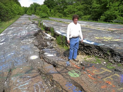
CENTRALIA, Pa. — It’s an anniversary the few remaining souls who live here won’t be celebrating.
Fifty years ago on Sunday, a fire at the town dump ignited an exposed coal seam and still burns today. It set off a chain of events that eventually led to the demolition of nearly every building in Centralia — a whole community of 1,400 simply gone.
All these decades later, the Centralia fire maintains its grip on the popular imagination, drawing visitors from around the world who come to gawk at twisted, buckled Route 61, at the sulfurous steam rising intermittently from ground that’s warm to the touch, at the empty, lonely streets where nature has reclaimed what coal-industry money once built. It’s a macabre story that has long provided fodder for books, movies and plays — the latest one debuting in March at a theater in New York.
Yet to the handful of residents who still occupy Centralia, who keep their houses tidy and their lawns mowed, this borough in the mountains of northeastern Pennsylvania is no sideshow attraction. It’s home, and they’d like to keep it that way.
“That’s all anybody wanted from day one,” said Tom Hynoski, who’s among the plaintiffs in a federal civil rights lawsuit aimed at blocking the state of Pennsylvania from evicting them.
Centralia was already a coal-mining town in decline when the fire department set the town’s landfill ablaze on May 27, 1962, in an ill-fated attempt to tidy up for Memorial Day. The fire wound up igniting the coal outcropping and, over the years, spread to the vast network of mines beneath homes and businesses, threatening residents with poisonous gases and dangerous sinkholes.
After a contentious battle over the future of the town, the side that wanted to evacuate won out. By the end of the 1980s, more than 1,000 people had moved and 500 structures were demolished under a $42 million federal relocation program.
But some holdouts refused to go — even after their houses were seized through eminent domain in the early 1990s. They said the fire posed little danger to their part of town, accused government officials and mining companies of a plot to grab the rights to billions of dollars’ worth of anthracite coal, and vowed to stay put.
After years of letting them be, state officials decided a few years ago to take possession of the homes. The state Department of Community and Economic Development said Friday it’s in negotiations with one of the five remaining homeowners; the others are continuing to resist, pleading their case in federal court.
Residents say the state has better things to spend its money on. A handwritten sign along the road blasts Gov. Tom Corbett, the latest chief executive to inherit a mess that goes back decades.
“You and your staff are making budget cuts everywhere,” the sign says. “How can you allow [the state] to waste money trying to force these residents out of their homes? These people want to pay their taxes and be left alone and live where they choose!”
Whether it’s safe to live there is subject to debate.
Tim Altares, a geologist with the Pennsylvania Department of Environmental Protection, said that while temperatures in monitoring boreholes are down — possibly indicating the fire has followed the coal seam deeper underground — the blaze still poses a threat because it has the potential to open up new paths for deadly gases to reach the remaining homes.
“It’s very difficult to quantify the threat, but the major threat would be infiltration of the fire gases into the confined space of a residential living area. That was true from the very beginning and will remain true even after the fire moves out of the area,” Mr. Alteres said.
Nonsense, say residents who point out they’ve lived for decades without incident.
Carl Womer, 88, whose late wife, Helen, was the leader of a faction that fiercely resisted the government buyout, disagrees the fire poses any threat.
“What mine fire?” Mr. Womer asked dismissively as he hosed down his front porch, preparing, he said, for a Memorial Day picnic. “If you go up and see a fire, you come back and tell me.”
Author and journalist David DeKok, who has been writing about Centralia for more than 30 years, said that while he believes Mr. Womer’s house is too close to the fire to safely live there, Mr. Hynoski and his neighbors are far enough away.
“I don’t think there’s any great public safety problem in letting those people stay there,” said Mr. DeKok, author of “Fire Underground,” a book on the town.
Many former residents, meanwhile, prefer to talk about the good times, their nostalgia taking on a decidedly golden hue.
“I loved it. I always liked Centralia from the time I was old enough to understand what it was,” said Mary Chapman, 72, who left in 1986 but returns once a month to the social club at the Centralia fire company.
“If you came out of your house and you couldn’t get your car started, the neighbor would come out and he’d help you. You didn’t even have to ask,” Ms. Chapman continued. “Of course the neighbors knew your business, but they also were there to help you, too.”
*************************************************************************************************************
[In accordance with Title 17 U.S.C. Section 107, this material is distributed without profit, for research and/or educational purposes. This constitutes ‘FAIR USE’ of any such copyrighted material.]


