Cyclone threatens to disrupt search for missing MH370
April 21, 2014
Australian Navy officer Morgan Macdonald stands in a rigid hull inflatable boat as he observes markers dropped from a Royal New Zealand Air Force (RNZAF) P3K Orion, after an object was sighted in the southern Indian Ocean. – Reuters pic, April 21, 2014.A tropical cyclone was threatening to hamper the search for the missing Malaysia Airlines flight today, as a submarine drone neared the end of its mission scouring the southern Indian Ocean sea bed with still no sign of wreckage.
The search for flight MH370, which vanished on March 8 with 239 people on board, has narrowed to a 10 sq km patch of sea floor about 2,000 km west of the Australian city of Perth.
Search authorities and the Australian and Malaysian governments have said a series of sonar signals, or “pings”, traced to the area may have emanated from the plane’s “black box” and present the most credible lead as to its whereabouts.
However no pings have been detected in almost two weeks and authorities now fear that, with the flight data recorder’s battery several weeks past its expected expiry date, the black box may not emit further signals.
A US Navy remote controlled submarine, the Bluefin-21, was on its ninth mission scanning the largely unmapped stretch of sea bed where the pings are believed to have come from, with still no trace found, Australian search officials said today.
“Bluefin-21 has searched approximately two-thirds of the focused underwater search area to date. No contacts of interest have been found to date,” the Joint Agency Coordination Centre said in a statement.
MH370 search to be most costly ever at $100 mln: analysts
by Staff Writers Sydney (AFP) April 18, 2014
Malaysia warns of ‘huge’ cost in MH370 search Kuala Lumpur (AFP) April 17, 2014 – Malaysia warned Thursday that the cost of the search for flight MH370’s wreckage in the vast depths of the Indian Ocean will be “huge”, the latest sobering assessment by authorities involved in the challenging effort.“When we look at salvaging (wreckage) at a depth of 4.5 kilometres (2.8 miles), no military out there has the capacity to do it,” Transport and Defence Minister Hishammuddin Hussein told reporters in Kuala Lumpur.”We have to look at contractors, and the cost of that will be huge.”
The search in a remote stretch of ocean far off western Australia was enlivened in the past two weeks by the detection of signals believed to be from the Malaysia Airlines plane’s flight data recorders on the seabed.
But the transmissions have gone silent before they could be pinpointed, raising the spectre of a costly and extensive search of a large swathe of ocean floor at extreme depths.
Prime Minister Tony Abbott of Australia, which is leading the multi-national search, had earlier warned in an interview published Thursday that an autonomous US Navy sonar device that began scanning the seabed for wreckage on Monday would be given one more week.
If nothing is found, authorities would reassess how next to proceed in the unprecedented mission to find the plane, Abbott said in the Wall Street Journal.
The Bluefin-21 completed its first full scanning mission early Thursday.
An initial attempt was aborted when the sub hit its maximum depth at 4.5 kilometres. A second was cut short by unspecified “technical” troubles.
Hishammuddin said he agreed with Abbott, saying “there will come a time when we need to regroup and reconsider”.
“But in any event, the search will always continue. It’s just a matter of approach,” said Hishammuddin, who did not specify what any alternative approach would be.
Australia’s search chief Angus Houston said earlier this week that authorities already were looking at possible alternative methods, including undersea devices that can go deeper than the Bluefin-21, but he also gave no specifics.
The Beijing-bound Malaysia Airlines flight with 239 people aboard inexplicably veered off its Kuala Lumpur-Beijing course on March 8, and is believed to have crashed in the Indian Ocean.
The search for missing Malaysia Airlines Flight MH370 is set to be the most expensive in aviation history, analysts say, as efforts to find the aircraft deep under the Indian Ocean show no signs of slowing.
The Boeing 777 vanished on March 8 with 239 people on board, after veering dramatically off course en route from Kuala Lumpur to Beijing and is believed to have crashed in the sea off Australia.
Australia, which is leading the search in a remote patch of water described as “unknown to man”, has not put a figure on spending, but Malaysia has warned that costs will be “huge”.
“When we look at salvaging (wreckage) at a depth of 4.5 kilometres (2.8 miles), no military out there has the capacity to do it,” Transport and Defence Minister Hishammuddin Hussein said Thursday.
“We have to look at contractors, and the cost of that will be huge.”
Ravikumar Madavaram, an aviation expert at Frost & Sullivan Asia Pacific, said Malaysia, Australia and China, which had the most nationals onboard the flight, were the biggest spenders and estimated the total cost up to now at about US$100 million (72 million euros).
“It’s difficult to say how much is the cost of this operation … but, yes, this is definitely the biggest operation ever (in aviation history).
“In terms of costs this would be the highest,” he told AFP.
– Hopes rest on submersible –
In the first month of the search — in which the South China Sea and Malacca Strait were also scoured by the US, Malaysia, Singapore and Vietnam — the Pentagon said the United States military had committed US$7.3 million to efforts to find the plane.
Meanwhile the Indian Ocean search, in which assets have also been deployed by Australia, Britain, China, South Korea, Japan and New Zealand, has failed to find anything conclusive.
Hopes rest on a torpedo-shaped US Navy submersible, which is searching the ocean floor at depths of more than 4,500 metres (15,000 feet) in the vicinity of where four signals believed to have come from black box recorders were detected.
David Gleave, an aviation safety researcher at Britain’s Loughborough University, said the costs “will be of the order of a hundred million dollars by the time we’re finished, if we have found it (the plane) now”.
But he said the longer it took to find any wreckage, the more costs would mount because scanning the vast ocean floor “will take a lot of money because you can only search about 50 square kilometres (19 square miles) a day”.
by Staff Writers Perth, Australia (AFP) April 18, 2014
The mini-sub searching for missing flight MH370 has reached record depths well beyond its normal operating limits, officials said Friday as it dived on its fifth seabed mission.
With no results to show since the Boeing 777 carrying 239 people disappeared on March 8, Australia’s Prime Minister Tony Abbott has set a one-week deadline to locate the plane which is believed to have crashed in a remote area of the Indian Ocean west of Perth.
Searchers have extended the hunt beyond the normal 4,500 metre (15,000 feet) depth range of the US Navy’s Autonomous Underwater Vehicle (AUV) called Bluefin-21.
“The AUV reached a record depth of 4,695 meters during mission four,” the US Navy said. “This is the first time the Bluefin-21 has descended to this depth.
“Diving to such depths does carry with it some residual risk to the equipment and this is being carefully monitored,” a statement said.
Australia’s Joint Agency Coordination Centre (JACC) announced that the mini-sub had been deployed on a new mission as operations run round the clock.
“Data analysis from the fourth mission did not provide any contacts of interest,” it added.
The unmanned Bluefin-21 which maps the seafloor by sonar, has searched 110 square kilometres (43 square miles) to date, JACC said.
The UAV, which hit a technical snag on Tuesday had also re-surfaced Monday after breaching a pre-programmed maximum depth of 4.5 kilometres (2.8 miles).
JACC said Thursday night that the US manufacturer of the UAV, Phoenix International, had advised the risk was “acceptable”.
“This expansion of the operating parameters allows the Bluefin-21 to search the sea floor within the predicted limits of the current search area,” it said.
The Malaysia Airlines jet is believed to have crashed in the ocean after mysteriously vanishing while en route between Kuala Lumpur and Beijing.
Hopes for finding the plane have focused on the Bluefin-21 after signals believed to be from the plane’s flight data recorders on the seabed fell silent in recent days.
The submersible is being deployed from an Australian vessel to scan an uncharted seafloor at extreme depths, but Abbott said the Bluefin-21 would be given about a week as questions are asked about the massive costs.
Dismayed families of missing MH370 passengers have vowed to ‘get noisier’
Network Writers
News Corp Australia
April 22, 20149:33AM
Malaysia to issue death certificates in missing plane
The Malaysian government prepares to issue death certificates for passengers of missing flight MH370 but some families cling to the hope their loved ones are alive. Mana Rabiee reports.
Shock … relatives of the missing MH370 passengers at the Metro Park Hotel in Beijing on April 21, 2014. Picture: Wang ZhaoSource: AFP
FAMILY members of passengers lost on missing Malaysia Airlines 370 have criticised the Malaysian government for an investigation they say has been mismanaged.
Appearing on US morning television, Sarah Bajc, the girlfriend of Flight 370 American passenger Philip Wood, told Today host Matt Lauer passengers’ loved ones all just “wanted to go back to square one”.
“We just don’t believe they’re using proper evaluative techniques to check the data,” she said. “It’s day 45 and we’re basically on the same position we were on on the first day.”
We don’t know anything for sure,” she said. “We want to go back and start over again, but with new people looking at the information.”
Ms Bajc sent an email to the media, on behalf of “the united families of MH370”, detailing their complaints and concerns.
Despair … Sarah Bajc with her boyfriend Philip Wood, who was a passenger on missing Malaysian flight MH370. Picture: FacebookSource: Supplied
Among their grievances is the suggestion by the government it issues death certificates or pay compensation before the plane is found.
“Until they have proof, they have an obligation to make regular prepayments to the families in need, and they have an obligation to exert themselves beyond dozing and snickering in resolving this case,” the email says.
The families say they are gaining strength and prepared to get noisier in their criticisms. The letter signs of “WE ARE IN UTTER OUTRAGE, DESPAIR AND SHOCK!”
The Acting Minister of Transport in Malaysia has posted a comment to Twitter that he hopes to discuss with Angus Houston the status of the remaining third of the search area being combed by the Bluefin-21 unmanned submersible.
I personally hope 2 discuss with Angus Houston on status of remaining 1/3 of area covered by the Blue Fin 21 soon @aikmalismail@mykamarul
— Hishammuddin Hussein (@HishammuddinH2O) April 21, 2014
DETAILS OF TODAY’S SEARCH
Bluefin-21 is still scouring the ocean depths on its ninth mission trying to locate wreckage from MH370.
So far it has searched about two thirds of the underwater area, with no contacts of interest found to date.
Up to 10 military aircraft and 10 ships will be part of today’s visual search approximately 1500 kilometres north west of Perth.
Scattered showers are predicted to continue with south easterly winds and sea swells of up to three metres.
Watch Video HereMalaysia’s acting transport minister Hishammuddin Hussein briefs the media on Friday on the latest developments in the search for Malaysia Airlines flight MH370. He says claims by US officials that the plane continued for several hours after its last transmission have not been verified
9.56pm GMT
Summary
We’re going to wrap up our live blog coverage for the day. Here’s a summary of where things stand:
• No tangible clue to the fate of Malaysia Airlines flight 370 had emerged after a week of searching. The plane disappeared north of Kuala Lumpur in the early hours of 8 March with 239 people aboard.
• US ships, helicopters and surveillance aircraft expanded a search on the Indian Ocean side of Malaysia. India sent flights with heat sensors over the remote Andaman Sea islands. “We just have to take it little by little,” a US Navy commander said.
• Flight 370 made significant changes in altitude and took more than one turn after losing contact with ground control, in a pattern that suggests someone was flying it, the New York Times reported, quoting “American officials and others familiar with the investigation.”
• The Indian Ocean search intensified, an Obama administration official said Thursday, based on radar readings and automated transmissions from the plane that registered on a satellite network.
• A satellite company said its network had picked up “routine, automated signals” from the plane, but executives would not say for how long. Such pings are only received when the normal data transmission is not operating, once per hour, the company, Inmarsat, told the Guardian.
9.31pm GMT
Malaysia Airlines flight 370 made significant changes in altitude and took more than one turn after losing contact with ground control, in a pattern that suggests someone was flying it, the New York Times reports, quoting “American officials and others familiar with the investigation”:
Radar signals recorded by the Malaysian military appear to show the missing airliner climbing to 45,000 feet, above the approved altitude limit for a Boeing 777-200, soon after it disappeared from civilian radar and made a sharp turn to the west, according to a preliminary assessment by a person familiar with the data.
The radar track, which the Malaysian government has not released but says it has provided to the United States and China, then shows the plane descending unevenly to an altitude of 23,000 feet, below normal cruising levels, as it approached the densely populated island of Penang, one of the country’s largest. There, the plane turned from a southwest-bound course, climbed to a higher altitude and flew northwest over the Strait of Malacca toward the Indian Ocean.
The Times story cautions that data from engines and radar is “incomplete and difficult to interpret.” Read the full piece here.
Updated at 9.41pm GMT
9.28pm GMT
US ships are moving into the Indian Ocean to undertake a search “due west” of Kuala Lumpur, US Navy Commander William Marks of the US 7th Fleet has just told CNN from aboard the USS Blue Ridge Command Ship, positioned “a little northwest of the Malacca Strait” at 5am local time.
“As you look west, and you transition west to the Indian Ocean, ships alone are really not quite much of a solution, because of the expanse of the ocean,” Marks told CNN. “You have to look at what other assets you have.”
Marks said the navy was using helicopters and surveillance aircraft to look for MH370. “We’re looking essentially west of Kuala Lumpur … due west,” he said.
A P8 Poseidon aircraft has reached the Bay of Bengal and is patrolling for debris, the Navy told the Guardian, and the USS Kidd destroyer also is in the area, Marks said, adding that the search party now includes 57 ships and 40-some aircraft from 13 countries.
“We just have to take it little by little,” Marks said. “That’s the best we can do out here.”
Updated at 9.39pm GMT
8.40pm GMT
Some theorists of the fate of MH370 have picked up on a South China Morning Post story from Friday that suggests an 8 March seismic event on the sea floor between Vietnam and Malaysia may have been tied somehow to the plane’s demise.
The SCMP includes what it says is a statement by Chinese seismologists explaining that “It was a non-seismic zone, therefore judging from the time and location of the event, it might be related to the missing MH370 flight.”
Not hardly true, according to US Geological Survey scientists. “The location coincides with a region of regularly occurring seismicity along the Sunda-Java trench,” the USGS said in a report quoted by NBC News.
“The bump from the plane hitting bottom of the ocean would not be noticeable,” earthquake expert John Vidale of the University of Washington told USA Today.
The location — southwest of Sumatra — is also prone to volcanoes, the USGS added.
Updated at 8.53pm GMT
6.30pm GMT
Guardian transport correspondent Gwyn Topham (@GwynTopham) has confirmed with the satellite company Inmarsat that its network registered “routine automated signals” from MH370.
“The signals, described as a series of ‘pings’ to the satellite, indicated that its communication system was still working, but not transmitting data,” Gwyn writes, and “such pings are only received when the normal data transmission is not operating, once per hour. The information would support theories that the plane’s system was deliberately switched off”:
David Coiley, vice president, aviation, at Inmarsat, said: “When the system is not transmitting or receiving data on the aircraft, it will send network signalling info to establish that the aircraft satellite communication is switched on, to say that the system could communicate. If we haven’t seen any activity from an aircraft or ship it’s a check. It’s a simple acknowledgement.
“The ping doesn’t say anything other than that the satellite communications is functioning.”
Coiley said an analogy was signalling that mobile phones use that is noticeable as interference (eg near radios) even when not in use, as they establish contact with networks.
Such signals would not transmit location but can indicate a position and distance relative to the satellite which could give a guide to a rough direction of travel over several hours.
The Inmarsat system is installed in over 90% of long haul passenger planes worldwide.
Coiley told Gwyn that any total absence of communication during normal aviation would be “a highly unusual situation. The systems are designed to allow people to communicate when they want to communicate, constantly.”
Updated at 6.39pm GMT
5.32pm GMT
The Associated Press quotes an unnamed US official as saying the MH370 transponder stopped “about a dozen minutes before a messaging system on the jet quit.” The official calls it “key evidence for [possible] human intervention,” AP reports.
It wasn’t clear what “messaging system” the report referred to, however. An unnamed senior Obama administration official was quoted Thursday as saying that the plane continued to send out some Aircraft Communications and Reporting System (ACARS) data for hours after it lost contact with ground control, and a satellite company said its network had registered “routine, automated signals” from the plane.
In other timelines, the loss of ACARS has been placed before the loss of the transponder. Malaysia Airlines chief executive Ahmad Jauhari Yahya said early Thursday that the last (ACARS) data were sent at 1:07 a.m., 14 minutes before the transponder signal was lost. Malaysian officials’ statements have proven inconsistent.
4.01pm GMT
Summary
• The search for MH370 grew on the Indian Ocean side of Malaysia as military radar readings and satellite readings appeared to suggest the plane flew west for hours. India began conducting overflights with heat sensors of the remote Andaman Sea islands.
• A satellite company said its network registered “routine, automated” signals from the flight. The Guardian is seeking confirmation of reports that the signals lasted hours.
• Two unnamed sources close to the investigation told Reuters that radar showed an unidentified aircraft believed to be MH370 following a route between navigational waypoints in the direction of the Andaman Islands. Malaysia requested additional raw radar data from its neighbors.
• Malaysian officials acknowledged speculation that the plane flew for hours after losing contact and said teams were “working on verifying that detailed information.”
• There has been no confirmed sighting of debris from MH370 a week after it disappeared with 239 passengers on board. The search operation now involves 57 ships, 48 aircraft, and 13 countries.
Updated at 4.09pm GMT
3.32pm GMT
The MH370 pilots were “a middle-aged family man passionate enough about flying to build his own simulator and a 27-year-old contemplating marriage who had just graduated to the cockpit of the Boeing 777,” the Associated Press reports:
Police have said they are looking at the psychological background of the pilots, their family life and connections as one line of inquiry into flight MH370’s disappearance, but there is no evidence linking them to any wrongdoing.
The plane was flown by Zaharie Ahmad Shah, 53, and Fariq Abdul Hamid, 27, who was featured in recent a CNN report:
Fariq, the son of a high-ranking civil servant in Selangor state, joined Malaysia Airlines in 2007. With just 2,763 hours of flight experience he had only recently started co-piloting the sophisticated Boeing 777.
He had a short brush with fame when he was filmed recently by a crew from “CNN Business Traveler.” Reporter Richard Quest called it a perfect landing of a Boeing 777-200, the same model as the twin-aisle plane that went missing. An online tribute page to the pilots shows a photo of Fariq in the cockpit with Quest, both smiling.
Neighbor Ayop Jantan said he had heard that Fariq was engaged and planning his wedding. The eldest of five children, his professional achievements were a source of pride for his father, said Ayop, a retiree.
Fariq’s superior, Zaharie, joined Malaysia Airlines in 1981 and has more than 18,000 flight hours.
Inmarsat, the £3bn satellite company, registered “routine, automated signals” from MH370 on its network, the company said in a brief statement on its website.
The statement does not mention for how long the signals were received or when they stopped.
14 March 2014: Inmarsat has issued the following statement regarding Malaysia Airlines flight MH370.
Routine, automated signals were registered on the Inmarsat network from Malaysia Airlines flight MH370 during its flight from Kuala Lumpur.
This information was provided to our partner SITA, which in turn has shared it with Malaysia Airlines.
For further information, please contact Malaysia Airlines.
“Such signals are very reliable,” but would not indicate location, an Inmarsat executive told NPR’s Frank Langfitt:
David Coiley, vice president of aviation at Inmarsat, declined in an interview to discuss the specifics of the Malaysia Airlines case. But he said that in general, such signals are very reliable. ‘I‘d say way over 99 percent. It’s highly unusual to get a false positive that the system was still operating when in fact it wasn’t,’ he said.” […]
Coiley, the Inmarsat executive, told Frank that the pings received by its satellites would not include data on altitude or a plane’s position.
Updated at 3.19pm GMT
2.55pm GMT
India’s navy says it has nearly doubled the number of ships and planes deployed to search the Andaman Sea, according to AFP.
It said six ships and five aircraft were now scouring for any sign of the vanished plane in the Andaman Sea, which surrounds India’s remote Andaman and Nicobar group of islands.
“We want to cover the area and it should be strictly done,” Indian naval spokesman DK Sharma told AFP.
India had earlier deployed three ships and three aircraft in the search.
The Indian ships and aircraft were looking in an area “designated” by the Malaysian navy in the southern region of the Andaman Sea, Sharma said.
File photographs of clouds hanging over the North Sentinel Island, in India’s southeastern Andaman and Nicobar Islands. India used heat sensors on flights over hundreds of uninhabited Andaman Sea islands on Friday, and will expand its search for the missing Malaysia Airlines jet farther west into the Bay of Bengal, officials said. Photograph: Gautam Singh/AP
In a Facebook update he paid tribute to the tireless efforts of those involved in the operation.
Malaysian Prime Minister Najib Razak prays for passengers and crew of missing Malaysia Airlines flight MH370 at mosque near Kuala Lumpur International Airport, Malaysia. Photograph: He Jingjia/REX
Tomnod is run by commercial satellite company DigitalGlobe, which soon after the plane’s disappearance repositioned two of its five satellites over its last known location in the Gulf of Thailand, and have since moved them as the search headed west.
Tomnod users are provided with a randomly chosen map from the search area and are told to drop a pin if they see signs of aeroplane wreckage, life rafts, oil slicks or anything that looks “suspicious”.
An algorithm then finds where there is overlap in tags from people who tagged the same location, and the most notable areas are shared with authorities. A Tomnod spokesperson said that as of Thursday every pixel had been looked at by human eyes at least 30 times.
Despite the huge online search party, the Tomnod hunt has so far have proved inconclusive. But that – and the fact crowdsourcing was disastrously discredited during the hunt for the Boston bombers and the search for adventurer Steve Fossett’s single-engine plane – hasn’t stopped millions of people searching the maps and tagging over 745,000 images they believe may be signs of the missing Malaysian Airlines plane.
Indian aircraft have searched over the Andaman and Nicobar Islands, after suggestions that the missing plane last headed towards the heavily forested archipelago, according to Reuters.
Popular with tourists and anthropologists alike, the islands form India’s most isolated state. They are best known for dense rainforests, coral reefs and hunter-gatherer tribes who have long resisted contact with outsiders.
Two sources told Reuters the unidentified aircraft appeared to be following a commonly used navigational route that would take it over the islands.
The Indian Navy has deployed two Dornier planes to fly across the island chain, a total area of 720 km (447 miles) by 52 km), Indian military spokesman Harmeet Singh said in the state capital, Port Blair. So far the planes, and a helicopter searching the coast, had found nothing.
“This operation is like finding a needle in a haystack,” said Singh, who is the spokesman for joint air force, navy and army command in the Andaman and Nicobar islands.
The Defence Ministry said the Eastern Naval Command would also search across a new area measuring 15 km by 600 km along the Chennai coast in the Bay of Bengal.
The shape of this area, located 900 km west of Port Blair, suggested the search was focusing on a narrow flight corridor.
Royal Malaysian Air Force Navigator captain, Izam Fareq Hassan and pilot major Ahmad Shazwan Mohammed show locations on a map during a search and rescue operation to find the missing Malaysia Airlines flight MH370 plane over the Strait of Malacca. Photograph: Mohd Rasfan/AFP/Getty Images
1.27pm GMT
The USS Kidd is en route to the western tip of the Strait of Malacca to aid the search at the request of the Malaysian government, writes the Guardian’s US security editor Spencer Ackerman.
It left from the Gulf of Thailand yesterday and the Navy expects it will be in the Strait by Saturday, according to navy spokeswoman Lauryn Dempsey.
Additionally, a P8 Poseidon surveillance plane is also on its way to the area, flying from Kadena Air Force Base in Japan.
These are the only planned US military assets aiding the search at the moment. The USS Pinckney, which was in the Gulf of Thailand to aid the search,
has now returned to the Strait of Singapore for pre-planned maintenance.
The Arleigh Burke-class guided-missile destroyers USS Kidd and USS Pinckney are seen en transit in the Pacific Ocean in this US Navy picture taken May 2011. Photograph: US NAVY/REUTERS
The Chinese are joining the westward focus of the search. The marine patrol ship Haixun 31 is heading for the Strait of Malacca, according to the state news agency Xinhua.
China’s marine patrol ship Haixun 31 is heading for Strait of Malacca to search for missing jet pic.twitter.com/ixrRezdLxe
Satellite data shows hijacked MH370 was last seen flying towards Pakistan OR Indian Ocean as investigators search pilots’ luxury homes and reveal one had home-made flight simulator
Officials confirmed missing plane was hijacked by one or several people
Could have turned off communication system and steered it off-course
Now believed plane could have flown for another seven hours
Malaysian Prime Minister Najib Razak refused to confirm the reports
Investigators working to establish motive and where plane was taken
Both captain and co-pilot are now said to be under investigation
Police raided the pair’s luxury homes in upmarket Kuala Lumpur suburb
PUBLISHED: 23:29 EST, 14 March 2014 | UPDATED: 15:32 EST, 15 March 2014
Investigators say the missing Malaysia Airlines jet was hijacked, steered off-course and could have reached Pakistan.
A Malaysian government official said people with significant flying experience could have turned off the flight’s communication devices.
The representative said that hijacking theory was now ‘conclusive’, and, as a result, police have raided the luxury homes of both the captain and the co-pilot.
The last known position of MH370 was pinpointed as it headed east over Peninsular Malaysia. Radar pings then suggest the plane could have then taken two paths along ‘corridors’ which are currently being searched, which are a fixed distance from the radar station in the Indian Ocean (left)
Entrance: The gates outside the home of co-pilot Fariq Abdul Hamid which has been searched by police
Journalists gathered outside Hamid’s home in Shah Alam as police turned their attention to those on board as part of the wide-ranging probe
Investigators have now raided the homes of both Capt. Zahari Ahmad Shah (left) and Fariq Abdul Hamid in the Malaysian capital of Kuala Lumpur
Zahari Ahmad Shah, 53, the pilot, and Fariq Abdul Hamid, 27, are now being investigated as police in Kuala Lumpur search for signs of foul play.
The search operation has now been focused on two ‘corridors’, one which extends from north west from Thailand to the Kazakstan-Turkmenistan border and the other which opens out into the southern Indian Ocean.
WHAT DOES NEW RADAR SIGNAL FROM SEVEN HOURS INTO FLIGHT MEAN?
The ‘corridors’ stretching north and south through the countries surrounding Malaysia are based on a satellite reading from seven and a half hours after the flight took off.
When the signal was received at 8.11am on March 8, the plane could have been anywhere along the red lines pictured above.
When the satellite in question received the signal, beamed into space, all it could tell would be how to adjust its systems to get a stronger read, an official told the Washington Post.
Combined with previous data, and the maximum flight distance of the plane, investigators have been able to plot a rough area from which they think the signal would have come.
The data cannot show where exactly the plane was, or which direction it was travelling in.
Countries in the plane’s potential flightpath have now joined a huge diplomatic effort to locate the missing passengers, but China described the revelation as ‘painfully belated’.
While Malaysian Prime Minister Najib Razak refused to confirm that flight MH370 was taken over, he admitted ‘deliberate action’ on board the plane resulted in it changing course and losing connection with ground crews.
The plane’s communication system was switched off as it headed west over the Malaysian seaboard and could have flown for another seven hours on its fuel reserves.
It is not yet clear where the plane could have been taken, however Mr Razak said the most recent satellite data suggests the plane could have headed to one of two possible flight corridors.
Countries in the plane’s potential flightpath have now joined a huge diplomatic effort to locate the missing passengers, but China described the revelation as ‘painfully belated’.
While Malaysian Prime Minister Najib Razak refused to confirm that flight MH370 was taken over, he admitted ‘deliberate action’ on board the plane resulted in it changing course and losing connection with ground crews.
The plane’s communication system was switched off as it headed west over the Malaysian seaboard and could have flown for another seven hours on its fuel reserves.
Compound: A view of the entrance to Capt. Zaharie Ahmad Shah’s residence. Police have been stationed outside for the last week
Luxury: Shah is said to live at the property with his wife Faisa
Officers are said to have spent two hours searching the pilot’s home today inside the luxury compound
Both pilots live in the upmarket Kuala Lumpur district of Laman Seri, about an hour’s drive from the city centre
A security guard stands at a main gate of the missing Shah’s house in Shah Alam, outside Kuala Lumpur
Shah’s property would have looked similar to this one and is set in an estate which is said to be popular with high-income earners
It is not yet clear where the plane was taken, however Mr Razak said the most recent satellite data suggests the plane could have headed to one of two possible flight corridors.
The last radar contact was made at 8.11am on March 8 along one of the corridors, seven hours and 31 minutes after take off, but the plane could have deviated further from these points.
U.S. investigators have not ruled out the possibility that the passengers are being held at an unknown location and suggest that faint ‘pings’ were being transmitted for several hours after the flight lost contact with the ground.
NASA has also joined the international search operation, analysing satellite data and images that have already been gathered.
Malaysian authorities and others are urgently investigating the two pilots and 10 crew members, along with the 227 passengers on board.
WHY DIDN’T RADAR FIND THE PLANE?
Radar coverage of the area where flight MH370 went missing is patchy and often not even switched on, according to aviation experts.
It has emerged today that civilian systems do not cover large swatches of the areas the plane could have gone, and that military systems are often left off to save money.
Air Vice Marshal Michael Harwood, a former RAF pilot, said: ‘Too many movies and Predator [drone] feeds from Afghanistan have suckered people into thinking we know everything and see everything.
‘You get what you pay for. And the world, by and large, does not pay.’
Air traffic control teams rely transponders signals to track planes- but investigators believe that the device was intentionally switched off on the missing aircraft.
Military systems, meanwhile, are often limited, switched off , or routinely ignore aircraft they do not think are suspicious.
A Rear Admiral in the Indian armed forces, which are aiding search efforts over the Andaman Islands, said: ‘It’s possible that the military radars were switched off as we operate on an “as required” basis.’
However, experts have suggested that a disappearing transponder signal would be treated more seriously over Europe or America, and that a parallel situation would be unlikely to develop.
Today, a police van with a large contingent of officers inside passed through a security gate at the entrance to the wealthy compound where father-of-three Captain Zaharie Ahmad Shah lives with his wife Faisa.
Four plain-clothed police officers were also, reportedly, seen at the home of the other pilot Fariq Abdul Hamid, 27.
Both pilots live in the upmarket Kuala Lumpur district of Laman Seri, about an hour’s drive from the city centre – and each was visited today by a team of detectives who arrived in a white ‘people mover’ vehicle.
The homes are substantial and are, said one resident, typical of high income earners.
It is believed a team of search specialists entered Shah’s house and spent two hours searching for signs of foul play, before moving into search the co-pilot’s home a short distance away.
The New Straits Times reported last night that before police turned up at Hamid’s home, his two brothers arrived there in a Mini Cooper, believed to belong to a friend.
They hurried into the house and remained there for a short time before hurrying away in the same car, taking with them transparent blue plastic bags containing clothes and toiletries.
Hamid’s father, Abdul Hamid left with them. An hour later, the plain clothed officers left the house carrying two brown bags.
The concentration by police on the homes of the Captain and the co-pilot adds to suspicion that one – or both – of them might have had been responsible for the plight of the aircraft.
However, if it was diverted into the Indian Ocean, the task of the search teams becomes more difficult, as there are hundreds of uninhabited islands and the water reaches depths of around 23,000ft.
The maximum range of the Boeing 777-200ER is 7,725 nautical miles or 14,305 km.
It is not clear how much fuel the aircraft was carrying though it would have been enough to reach its scheduled destination, Beijing, a flight of five hours and 50 minutes, plus some reserve.
Experts have previously said that whoever disabled the plane’s communication systems and then flew the jet must have had a high degree of technical knowledge and flying experience.
In Shah’s house a flight simulator has been set up and is understood to have interested police following up one line of investigation – that he had used the equipment to practice making his real-life Boeing 777 ‘invisible’ by turning off all communications.
by Agence France-Presse Posted on 05/14/2013 7:35 AM | Updated 05/14/2013 7:35 AM
GIANT STORM. NASA’s Aqua satellite captured this visible image of a well-rounded Tropical Cyclone Mahasen in the Northern Indian Ocean on May 15 at 07:55 UTC (3:55 a.m. EDT). Mahasen is northeast of Sri Lanka and moving northward. NASA Goddard MODIS Rapid Response TeamCHITTAGONG, Bangladesh – Bangladesh warned millions of people Monday, May 13, that a cyclone could barrel into their coastal homes later this week as authorities in Myanmar began moving potential victims to higher ground.
The Bangladesh Meteorological Department said that while it was too soon to predict where cyclonic storm Mahasen would hit, it raised its alert to four, meaning “there are increased chances that the cyclone will hit the coast”.
The department’s deputy head Shamsuddin Ahmed said Mahasen was currently in the Bay of Bengal, 1,355 kilometers (840 miles) south west of Chittagong, and could make landfall in the southeast of the country on Thursday.
“Mahasen is still a cyclonic storm. It has not gathered enough strength to become a severe cyclone. But it is likely to intensify further,” he told AFP.
The government has made preparations for the cyclone, but will wait until it has firmer information as to where it would make landfall before issuing any evacuation order, Chittagong provincial administrator Muhammad Abdullah said.
“We’ve alerted the people living in coastal areas, but have not evacuated any of them because we still don’t know where the cyclone will hit. But we’re fully prepared to face any situation,” he told AFP.
He said authorities have set up logistics support and kept cyclone preparedness volunteers, doctors and officials ready for the cyclone.
Around 30 million of Bangladesh’s population of 153 million live along the coast, and Chittagong is the country’s second largest city.
Monday’s warning from Bangladesh echoed a similar alert from Myanmar’s Department of Meteorology and Hydrology at the weekend.
NASA’s Aqua satellite captured this visible image of a well-rounded Tropical Cyclone Mahasen in the Northern Indian Ocean on May 15 at 07:55 UTC (3:55 a.m. EDT). Mahasen is northeast of Sri Lanka and moving northward. Credit: NASA Goddard MODIS Rapid Response Team NASA Sees a Strengthening Tropical Cyclone Mahasen
The first tropical cyclone in the Northern Indian Ocean this season has been getting better organized as seen in NASA satellite imagery. Tropical Cyclone Mahasen is projected to track north through the Bay of Bengal and make landfall later this week.
The Moderate Resolution Imaging Spectroradiometer (MODIS) instrument aboard NASA’s Aqua satellite captured a visible image of Tropical Cyclone Mahasen in the Northern Indian Ocean on May 15 at 07:55 UTC (3:55 a.m. EDT). The image was created by NASA’s MODIS Rapid Response Team at NASA’s Goddard Space Flight Center in Greenbelt, Maryland and showed Mahasen had consolidated over the last two days. Mahasen appeared rounded and its strongest thunderstorms appeared to be surrounding the center of circulation. The center also appears to be topped with a large dense overcast. The image showed Mahasen’s center was northeast of Sri Lanka, although a band of strong thunderstorms south of the storm’s center were affecting the island nation at the time of the image.
Tropical Cyclone Mahasen (TC 01B) is getting better organized. Winds are predicted to increase to hurricane force as the system moves further northward into the Bay of Bengal. TC Mahasen is now located east-northeast of Sri Lanka and is expected to impact areas from northeast India to Bangladesh and Myanmar.
According to latest report by Joint Typhoon Warning Center (JTWC), TC Mahasen is located approximately 721 nm southward of Calcutta, India. The system is moving north-northwestward at speed of 6 knots. Maximum sustainable winds are 55 knots with gusts up to 70 knots.
Indian Ocean IR satellite image of the system on May 12, 2013 (Credit: METEOSAT-7/CIMSS)
The cyclone is beginning to round the western edge of the subtropical ridge to the east. It is expected to slow down over the next 24 hours as it makes the turn before recurving northeastward on the poleward side of the ridge axis. TC Mahasen will gradually intensify as the vertical wind shear relaxes along the ridge axis. Additionally, the poleward outflow is expected to open up as the system becomes exposed to the prevailing westerlies.
Animated infrared satellite imagery shows the system has regained a central dense overcast feature that has, once again, obscured the low level circulation center. Upper level analysis indicates the system is 7 degrees south of the ridge axis in an area of moderate (20 knot) easterly vertical wind shear. However, the vertical wind shear is offset by robust westward outflow.
After the next 72 hours, TC Mahasen will gradually weaken as vertical wind shear increases before making landfall near Chittagong, Bangladesh. Land interaction will rapidly erode and dissipate the system.
TC Mahasen forecast track (Source: JTWC)
According to Indian Meteorological Department (IMD), under the influence of this system, rainfall at many places with isolated heavy rainfall would occur over Andaman and Nicobar Islands during next 48 hours. Squally winds speed reaching 40-45 km/h gusting to 60 km/h would prevail along Andaman and Nicobar Islands during next 48 hours. Sea condition will be rough to very rough along and off Andaman and Nicobar Islands during this period.
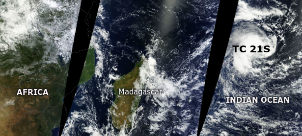
New tropical disturbance is taking shape in waters of Indian Ocean. According to latest report by Joint Typhoon Warning Center (JTWC), Tropical Cyclone 21S is located approximately 335 nm south- southwest of Diego Garcia, and is moving south-westward at speed of 11 knots.
MODIS satellite image captured on April 7, 213 (Credit: LANCE/MODIS/Worlview)
Animated infrared satellite imagery depicts a partially-exposed low-level circulation center located east of persistent deep convection. Sustainable winds of 35-40 knot were recorded over the western portion of the low level circulation center, which are wrapping into the center. Upper-level analysis indicates TC 21S is approximately five degrees equatorward of the subtropical ridge axis. Vertical wind shear remains moderate (15-20 knots), causing the deep convection to be sheared to the west. Animated water vapor imagery depicts moderate poleward outflow; however, equatorward outflow is limited due to troughing.
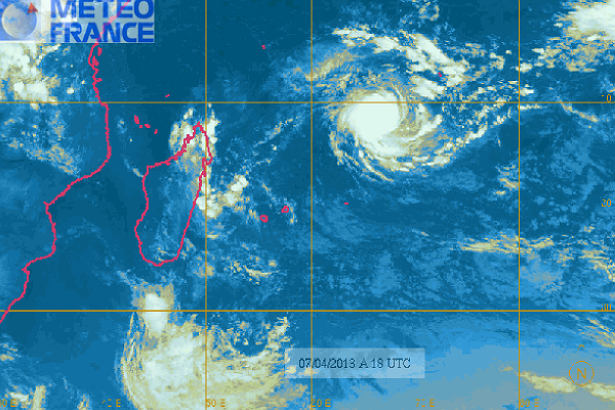
Meteosat’s Southwest Indian Ocean Infrared satellite image (Credit: Météo France)
At least 10 people have been killed in flash floods in Mauritius and more downpours could be on the way, officials and the Indian Ocean island’s meteorological service said on Sunday. The deaths occurred on Saturday and most of the victims were trapped in an underpass leading to the Caudan Waterfront, a commercial area in Port Louis. Prime Minister Navinchandra Ramgoolam said on Sunday that Port Louis had a torrential downpour with 152 mm falling in two hours. “The speed of the torrents of water has led to tragic loss of life and heavy damage to property,” he said, adding that he was declaring Monday a day of mourning. The Mauritius meteorological service said showers were expected overnight and on Monday, with isolated thunderstorms that could cause further floods.
At least 10 people have been killed in flash floods in Mauritius and more downpours could be on the way, officials and the island’s meteorological service has said.
Most of the victims were trapped in an underpass leading to the Caudan Waterfront, a commercial area in Port Louis.
Prime Minister Navinchandra Ramgoolam said Port Louis had had a torrential downpour, with 152 mm falling in two hours.”The speed of the torrents of water has led to tragic loss of life and heavy damage to property,” he said.
The Mauritius meteorological service said showers were expected overnight and on Monday, with isolated thunderstorms that could cause further floods.
Published: 9:19AM Monday April 01, 2013 Source: Reuters
At least 10 people have been killed in flash floods in Mauritius and more downpours could be on the way, officials and the Indian Ocean island’s meteorological service said today.
The deaths occurred on Sunday and most of the victims were trapped in an underpass leading to the Caudan Waterfront, a commercial area in Port Louis.
Prime Minister Navinchandra Ramgoolam said Port Louis had a torrential downpour with 152 mm falling in two hours.
“The speed of the torrents of water has led to tragic loss of life and heavy damage to property,” he said, adding that he was declaring Monday a day of mourning.
The Mauritius meteorological service said showers were expected overnight, with isolated thunderstorms that could cause further floods.
The Hunger Site – Your click helps to feed the hungry
Wheatgrass Kits.com
FAIR USE NOTICE
The material on this site is provided for educational and informational purposes. It may contain copyrighted material the use of which has not always been specifically authorized by the copyright owner. It is being made available in an effort to advance the understanding of scientific, environmental, economic, social justice and human rights issues etc. It is believed that this constitutes a 'fair use' of any such copyrighted material as provided for in section 107 of the US Copyright Law. In accordance with Title 17 U.S.C. Section 107, the material on this site is distributed without profit to those who have an interest in using the included information for research and educational purposes. If you wish to use copyrighted material from this site for purposes of your own that go beyond 'fair use', you must obtain permission from the copyright owner. The information on this site does not constitute legal or technical advice.
Any materials (ie. graphics, articles , commentary) that are original to this blog are copyrighted and signed by it's creator. Said original material may be shared with attribution. Please respect the work that goes into these items and give the creator his/her credit. Just as we share articles , graphics and photos always giving credit to their creators when available. Credit and a link back to the original source is required.
If you have an issue with anything posted here or would prefer we not use it . Please contact me. Any items that are requested to be removed by the copyright owner will be removed immediately. No threats needed or lawsuit required. If there is a problem and you do not wish your work to be showcased then we will happily find an alternative from the many sources readily available from creators who would find it amenable to having their work presented to the subscribers of this feed.
Thank you for your time and attention, blessings to all :)
 Australian Navy officer Morgan Macdonald stands in a rigid hull inflatable boat as he observes markers dropped from a Royal New Zealand Air Force (RNZAF) P3K Orion, after an object was sighted in the southern Indian Ocean. – Reuters pic, April 21, 2014.A tropical cyclone was threatening to hamper the search for the missing Malaysia Airlines flight today, as a submarine drone neared the end of its mission scouring the southern Indian Ocean sea bed with still no sign of wreckage.
 The search for flight MH370, which vanished on March 8 with 239 people on board, has narrowed to a 10 sq km patch of sea floor about 2,000 km west of the Australian city of Perth.


. Mahasen is northeast of Sri Lanka and moving northward. NASA Goddard MODIS Rapid Response Team")


