CEDAR RAPIDS, Iowa – Firefighters in Cedar Rapids rescued a dog from a floating piece of ice in the Cedar River Tuesday night.
At about 7:15 p.m., emergency crews responded to a report of a dog stranded on a chunk of ice floating on the Cedar River in the area of Otis Road, south of the Cargill Corn Milling facility.
Firefighters launched a boat carrying two firefighters and an animal control officer. When the crew reached the ice, the dog was frightened and continued to move from side to side of the ice to get away from rescuers.
Winter administered a fresh whipping to parts of the Northeast overnight, as a new storm brought more snow and high winds to the region.
The latest blast came as residents were still digging out from a major storm that caused at least 25 deaths, and at its height, left hundreds of thousands without power on the East Coast and in the South.
New England was absorbing the worst of the weekend storm, which was moving in Saturday evening. Up to 12 inches of snow fell in eastern Massachusetts, and parts of Maine and Rhode Island overnight, Weather Channel meteorologist Mark Swaim said.
New York City and Boston, which both saw flurries overnight, were waking up to lower than average temperatures: Upper 20s in Beantown and lower 30s in the Big Apple.
Massachusetts Gov. Deval Patrick on Saturday warned drivers to stay off the roads for a 12-hour period beginning at 5 p.m., saying, “It won’t be possible to keep up with the clearing of the roads.”
The newest storm spawned blizzard conditions in several places along the Massachusetts coastline, including Cape Ann, Hingham, Cape Cod and surrounding islands.
Another Winter Storm Batters East Coast
Nightly News
Boston Mayor Martin Walsh announced that the city would deploy more than 600 snow plows, trucks and other equipment by Saturday evening to deal with the storm. He said additional police officers, firefighters and paramedics would be on hand throughout the storm to ensure public safety.
Southeastern New Hampshire is under a winter storm warning through Sunday that could bring 6 to 10 inches of snow. The weather service said 1 to 2 inches of snow were possible on Saturday with as much as 8 inches overnight.
Further south, New York City New York City’s Central Park received 1 1/2 inches of new snow after getting nearly a foot of snow Thursday.
Good Samaritans help push a stranded motorist stuck in deep snow on Stefko Boulevard Thursday, Feb. 13, 2014 in Bethlehem, Pa. A wide swath of Pennsylvania awoke Thursday to a fresh coating of snow and a forecast for much more to come over the course of the day. (AP Photo/Chris Post)
BOSTON (AP) — Another winter storm began hitting southern New England on Saturday afternoon and meteorologists said the region will experience heavy snow, strong winds and blizzard conditions near the Massachusetts coast before the storm clears out on Sunday.
The National Weather Service said Massachusetts and parts of Rhode Island will bear the brunt of the storm, with 10 to 14 inches of snow.
“Connecticut will see heaviest snowfall amounts near the Rhode Island border, with lesser amounts as you head further west,” meteorologist William Babcock said. “So there might be 8 to 10 inches right along the Rhode Island border, maybe 4 to 6 around Willimantic and 2 to 4 around Hartford.”
At its peak, the storm will dump snow at the rate of up to 3 inches per hour, Babcock said.
Massachusetts Gov. Deval Patrick urged drivers to stay off the roads from 5 p.m. Saturday to 5 a.m. Sunday, and said “it won’t be possible to keep up with the clearing of the roads” during the storm.
The storm is expected to spawn blizzard conditions in several spots along the eastern Massachusetts coastline, including Cape Ann, Hingham, Cape Cod and surrounding islands.
“These areas could be seeing winds reaching up to 70mph, blowing snow and creating extremely poor visibility,” Babcock said. “People should be preparing for deteriorating conditions … People should be ready to stay off the roads and the good thing is a lot of this will be at night, when people are normally off the roads.”
The Rhode Island coast areas north and northwest of Boston will experience winds of up to 45mph that will blow the snow and create chilly conditions.
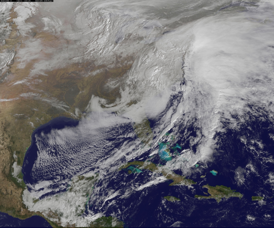
This visible image of the winter storm over the U.S. south and East Coast was taken by NOAA’s GOES-13 satellite on Feb. 13 at 1455 UTC/9:45 a.m. EST. Snow covered ground can be seen over the Great Lakes region and Ohio Valley. Image Credit: NASA/NOAA GOES Project
A deadly monster storm is battering virtually the entire US Eastern seaboard today, Thursday, Feb. 13, as it moves from the Southeast to the Northeast and into the New England states, wreaking havoc and causing miserable weather conditions for over 100 million Americas.
This afternoon, NASA and NOAA published a new image taken by a GOES satellite that showed the extent of the clouds associated with the massive winter storm over the US East Coast – see above and below.
Blizzard, white out and slippery conditions have already caused more than 18 deaths.
The killer storm has brought relentless waves of snow, sleet and ice over the past two days covering a vast swath stretching from inland to coastal areas as it moved up from the southern to northern states.
More than a foot of snow has already fallen in many areas today stretching from the Mid-Atlantic into the entire Northeast region.
Several states have declared states of emergency.
This is the season’s 12th snow storm. In many Northeast localities, the accumulated snowfall totals are three times the normal average. As a result many municipalities are running out of road salt.
And to add insult to injury, much more icy snow is falling overnight into Friday on top of the massive existing mounds and piles of frozen ice and snow that’s accumulated over the past few weeks of subfreezing temperatures.
There are also predictions for patches of “thunder snow” — which is a snow storm mixed with thunder and lightning!
Two major pileups and smaller fender-benders involving tractor-trailers and scores of cars blocked one side of an ice-coated Pennsylvania Turnpike outside Philadelphia on Friday, injuring at least 30 people and tying up traffic for hours.
The eastbound crashes were reported just before 8:30 a.m., in the middle of rush hour and about five hours after a storm that dropped a foot of snow in the area finally moved out.
Speed restrictions put in place during the storm had been lifted at 6 a.m., but rush-hour motorists said the roadway was very slick, calling into question whether it had been adequately treated. State police also suspect sun glare might have played a role.
The accidents created a five-mile traffic jam between the Bensalem and Willow Grove exits of the state’s primary east-west highway. The jam was cleared by the middle of the afternoon, and turnpike officials reopened the roadway in both directions by 4 p.m.
Stuck motorists turned off their engines to conserve gas. One of them, Chuck Wacker, 53, of Plymouth Meeting, counted about 30 smashed-up vehicles around him.
“It’s a pretty calm atmosphere right now,” he said. “People are sharing food and water.”
He said cars were spun around, gas tanks were cracked open and glass and plastic littered the road.
ATLANTA (AP) — In a dire warning Tuesday, forecasters said a potentially “catastrophic” winter storm threatened to bring a thick layer of ice to Georgia and other parts of the South, causing widespread power outages that could leave people in the dark for days.
Many people heeded the advice to stay home and off the roads, leaving much of metro Atlanta desolate during what is typically a busy morning commute. While only rain fell in the city, places 40 miles northwest saw 2 to 3 inches of snow. The rain was expected to turn to sleet and freezing rain and the ice coating was forecast for Wednesday.
When asked to elaborate on the “catastrophic” warning, Brian Hoeth, a meteorologist at the service’s southern regional headquarters in Fort Worth, Texas, said forecasters were talking about an ice storm that happens only once every 10 to 20 years for the area. Forecasters predicted crippling snow and ice accumulations as much as three-quarters of an inch in area from Atlanta to central South Carolina. Wind gusts up to 30 mph could exacerbate problems.
Aaron Strickland, emergency operations director for Georgia Power, said the utility is bringing in crews from Florida, Texas, Oklahoma and Michigan. Strickland, who has spent 35 years with Georgia Power, said he’s never seen an inch of ice in metro Atlanta.
“I’ve seen people forecast it, but it’s never come,” Strickland said. “And I’m hoping it don’t this time.”
President Barack Obama declared an emergency in Georgia, ordering federal agencies to help with the state and local response.
The quiet streets were a stark contrast to the scene just two weeks earlier when downtown roads were jammed with cars, drivers slept overnight in vehicles or abandoned them on highways. Students camped in school gymnasiums.
cWalkers cross the Hudson Memorial Bridge as a tractor trailer truck prepares to cross the Tennessee River into Decatur, Ala., Tuesday, Feb. 11, 2014. (AP Photo/The Decatur Daily, John Godbey)
ATLANTA—In a dire warning Tuesday, forecasters said a potentially “catastrophic” winter storm threatened to bring a thick layer of ice to Georgia and other parts of the South, causing widespread power outages that could leave people in the dark for days.
Many people heeded the advice to stay home and off the roads, leaving much of metro Atlanta desolate during what is typically a busy morning commute. While only rain fell in the city, places 40 miles northwest saw 2 to 3 inches of snow. The rain was expected to turn to sleet and freezing rain and the ice coating was forecast for Wednesday.
When asked to elaborate on the “catastrophic” warning, Brian Hoeth, a meteorologist at the service’s southern regional headquarters in Fort Worth, Texas, said forecasters were talking about an ice storm that happens only once every 10 to 20 years for the area. Forecasters predicted crippling snow and ice accumulations as much as three-quarters of an inch in area from Atlanta to central South Carolina. Wind gusts up to 30 mph could exacerbate problems.
Aaron Strickland, emergency operations director for Georgia Power, said the utility is bringing in crews from Florida, Texas, Oklahoma and Michigan. Strickland, who has spent 35 years with Georgia Power, said he’s never seen an inch of ice in metro Atlanta.
“I’ve seen people forecast it, but it’s never come,” Strickland said. “And I’m hoping it don’t this time.”
President Barack Obama declared an emergency in Georgia, ordering federal agencies to help with the state and local response.
The quiet streets were a stark contrast to the scene just two weeks earlier when downtown roads were jammed with cars, drivers slept overnight in vehicles or abandoned them on highways. Students camped in school gymnasiums.
“It looks like this time it’s not going to be bad until everyone’s home,” said Dustin Wilkes, 36, of Atlanta, who was one of the few people headed to the office.
Atlanta has a painful past of being ill-equipped to deal with snowy weather. Despite officials’ promises after a crippling ice storm in 2011, the Jan. 28 storm proved they still had many kinks to work out.
AP Photo: Atlanta Journal & Constitution, Curtis Compton
State agencies prepare for the approaching winter weather at the Georgia Emergency Management Agency State Operations Center on Monday, Feb. 10, 2014, in Atlanta.
By Christina A. Cassidy of Associated Press
Another round of rain, sleet and freezing rain is expected to begin walloping Atlanta and other parts of Georgia on Tuesday.
ATLANTA — Forecasters issued an unusually dire winter storm warning Tuesday for much of Georgia, but many residents were already heeding advice to stay home and off the roads, leaving much of metro Atlanta a ghost town during the usually busy morning commute.
New Winter Storm Aims for South
The storm could be a “catastrophic event” reaching “historical proportions,” the National Weather Service said in its warnings. Forecasters cited potentially crippling snow and ice accumulations, and they expected widespread power outages that could last for days. As much as three-quarters of an inch of ice is forecast for Atlanta, and wind gusts up to 25 mph could exacerbate problems.
Aaron Strickland, emergency operations director for Georgia Power, said the utility is already bringing in crews from Florida, Texas, Oklahoma and Michigan. Strickland, who has spent 35 years with Georgia Power, said he’s never seen an inch of ice in metro Atlanta.
“I’ve seen people forecast it, but it’s never come,” Strickland said. “And I’m hoping it don’t this time.”
Rain was falling Tuesday morning in Atlanta, with snow in north Georgia. Dustin Wilkes, 36, of Atlanta, was one of the few who headed to the office. “It looks like this time it’s not going to be bad until everyone’s home,” he said. He noticed his parking lot was mostly deserted.
It was a stark contrast to the storm that hit Atlanta two weeks earlier. Downtown streets were jammed with unmoving cars, highway motorists slept overnight in vehicles or abandoned them where they sat, and students were forced to camp in school gymnasiums.
Atlanta has a painful history of being ill-equipped to deal with snowy weather. Despite officials’ promises after a crippling ice storm in 2011, the Jan. 28 storm proved they still had many kinks to work out.
AP Photo: Atlanta Journal-Constitution, Ben Gray
Georgia Gov. Nathan Deal
Georgia Gov. Nathan Deal indicated Monday that he and other state officials had learned their lesson. Before a drop of freezing rain or snow fell, Deal declared a state of emergency for nearly a third of the state and state employees were told they could stay home. He expanded the declaration Tuesday to more than half the state’s counties.
On Monday, schools canceled classes, and Deal urged people who didn’t need to be anywhere to stay off the roads. Tractor-trailer drivers were handed fliers about the weather and a law requiring chains on tires in certain conditions.
“We are certainly ahead of the game this time, and that’s important,” Deal said. “We are trying to be ready, prepared and react as quickly as possible.”
Some residents thought officials moved too quickly. “I think they probably overreacted,” Wilkes said. “It’s to be expected.”
Travelers wait for flights at Hartsfield-Jackson International Airport in Atlanta, Thursday, Jan. 30, 2014.
By Associated Press
Hartsfield-Jackson Atlanta International Airport, the main hub for Delta Air Lines, led the nation in Tuesday flight cancellations with 368.
ATLANTA — As a winter storm with potential to coat the South with ice and snow moves in, nearly 900 flights have been cancelled at three of the region’s major airports.
Tracking service FlightAware shows that before dawn Tuesday, 894 flights for the day had been canceled into and out of the main airports in Atlanta, Dallas and Charlotte, N.C.
PUBLISHED: 01:34 EST, 9 February 2014 | UPDATED: 02:41 EST, 9 February 2014
Utility crews restored power to thousands of Pennsylvania homes Saturday and early Sunday, yet some customers in the dark for days after a tree-snapping ice storm may not regain power until early next week.
About 78,000 customers in Pennsylvania and Maryland remained without power early Sunday, and faced the prospect of yet another day without electric heat or light.
The majority of them are in the Philadelphia area, with utility PECO reporting about 77,500 outages, as of 1 a.m., down from about 155,000 earlier Saturday.
Frozen: About 78,000 customers in Pennsylvania and Maryland are still without power, and faced the prospect of yet another day without electric heat or light.
Snowed in: More than 1 million customers lost power at the ice storm’s peak
The latest outages include nearly 39,000 customers in hard-hit Chester County, or more than one in five customers.
Plumber Nate Petersen prepares a pump to shoot water into the incoming city water line, left pipe, that has been frozen at a south Minneapolis home. Roto Rooter was been inundated with calls since the cold snap and regular work has been put on hold because of burst pipes and even frozen sewer lines, according to plumbing manager Paul Teale.
A home in Brooklyn, N.Y., got colder and colder even as the owners turned up the heat, while a house in Paducah, Ky., had an inch of water in four rooms. They were both victims of water pipes that cracked in the deep freeze that has much of the nation in its icy grip.
America’s largest insurance company, State Farm, says it has had so many claims for frozen pipes — 28,000 in the Jan. 4-9 period of extreme cold — that it declared the situation a “catastrophe,” allowing it to bring in more adjusters to handle the overload. It said the payout for such claims can be as high as $15,000.
The American Insurance Association says 22 percent of all claims on home owner’s policies — 1 in 5 — are for cold weather damage, and its member companies pay out around $1.4 billion per year.
“We anticipate a large spike in frozen pipe claims,” said Peter Foley, the AIA’s vice president for claims. “In Washington, D.C., some of my colleagues have already had them in their own homes.”
Foley told NBC News that the problem with broken pipes is that very often you don’t notice them until the weather warms up and the ice thaws.
“The thing is, we are getting extreme cold temperatures in parts of the country where houses are not built to withstand it,” said Foley, whose own house in New Hampshire has water pipes under the floorboards, rather than running along exposed exterior walls.
Ilene Sacco, a homeowner in Brooklyn, can count herself lucky, even though she had to call out the plumber after she and her husband noticed is was getting a little bit cold, even when they turned up the radiators.
“Two pipes froze in the garage and one in the baseboard down the wall,” she said. “The one in the garage actually cracked … they had to cut out a piece and replace it.”
What saved her from more expensive damage was the fact that it stayed so cold outside. “There had been a chunk of ice in there. If it had melted, the water would have been all over the place.”
The Chicago skyline rises above the icy edge of Lake Michigan on Monday. The Midwest has been especially hard-hit by winter weather this month.
Why are the Midwest and the Southeast stuck in a deep freeze, while Alaska is suffering a perilous thaw this winter? The woes associated with this month’s unseasonably cold and warm temperatures all go back to the same root cause: a high-pressure ridge that’s been locked in for weeks over the American West. And if you think this winter’s weather is bad, just wait till this summer’s droughts kick in.
“A lot of this is connected,” said Brian Fuchs, a climatologist at the National Drought Mitigation Center in Lincoln, Neb. “As we’re seeing, the warmth and dryness in the West has implications all the way up to Alaska and also in areas to the east.”
The long-lasting ridge causes a kink in the jet stream, sending warm marine air from the Pacific up into Alaska and bringing cold Arctic air down into America’s heartland.
The effects are brutal: Midwesterners and Easterners already have suffered through a couple of cold waves, and this week’s big chill is disrupting air travel and spreading misery across a region stretching from Texas to Minnesota to the Carolinas. Meanwhile, Alaska’s thaw has triggered a mammoth avalanche, cutting off road access to the port of Valdez and stoking fears of flash floods.
Is it possible that this year’s drought and fire season will be even worse than last year’s? “The current water year, which started in October, is one of the driest on record that we’ve ever seen,” Fuchs told NBC News. “Even if we had near-record moisture from here on out, it would still be tough to make up the deficit.”
NASA via Cliff Mass
Two pictures from NASA’s Aqua satellite tell the tale for this year’s drought conditions in the western United States. The photo at left is Jan. 20, 2013. The photo at right is from Jan. 20, 2014. “Wow … what a difference,” says Cliff Mass, a weather researcher at the University of Washington.
Last year at this time, drought conditions were in effect for 54 percent of California’s land area, Fuchs said. Currently, 94 percent of the state is feeling the drought. “What’s happening in the western third of the U.S. is a strong, developing situation,” Fuchs said.
The Hunger Site – Your click helps to feed the hungry
Wheatgrass Kits.com
FAIR USE NOTICE
The material on this site is provided for educational and informational purposes. It may contain copyrighted material the use of which has not always been specifically authorized by the copyright owner. It is being made available in an effort to advance the understanding of scientific, environmental, economic, social justice and human rights issues etc. It is believed that this constitutes a 'fair use' of any such copyrighted material as provided for in section 107 of the US Copyright Law. In accordance with Title 17 U.S.C. Section 107, the material on this site is distributed without profit to those who have an interest in using the included information for research and educational purposes. If you wish to use copyrighted material from this site for purposes of your own that go beyond 'fair use', you must obtain permission from the copyright owner. The information on this site does not constitute legal or technical advice.
Any materials (ie. graphics, articles , commentary) that are original to this blog are copyrighted and signed by it's creator. Said original material may be shared with attribution. Please respect the work that goes into these items and give the creator his/her credit. Just as we share articles , graphics and photos always giving credit to their creators when available. Credit and a link back to the original source is required.
If you have an issue with anything posted here or would prefer we not use it . Please contact me. Any items that are requested to be removed by the copyright owner will be removed immediately. No threats needed or lawsuit required. If there is a problem and you do not wish your work to be showcased then we will happily find an alternative from the many sources readily available from creators who would find it amenable to having their work presented to the subscribers of this feed.
Thank you for your time and attention, blessings to all :)


")