5.1 quake rattles L.A., Orange County
A magnitude 5.1 earthquake centered in northern Orange County jostled the L.A. Basin, causing pictures to fall off walls, glass items to shatter and furniture to tumble. There were also reports of gas and water line damage and power outages.
Overturned vehicle
( Irfan Khan / Los Angeles Times / March 29, 2014 )
Caltrans workers and Brea police officers inspect a BMW that was overturned in a rock slide in Carbon Canyon after a magnitude 5.1 earthquake.
( Robert Gauthier / Los Angeles Times / March 28, 2014 )
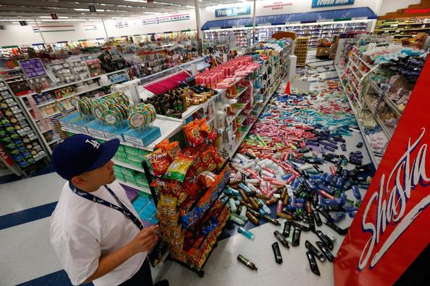
Cesar Zamora, night manager at the 99 Cent Only store on Imperial Highway, looks over aisles of fallen goods.
View Additional Photos Here
……
5.1 earthquake: Significant damage reported in some areas
By Louis Sahagun and Catherine Saillant
March 29, 2014, 1:18 p.m.
A series of temblors, punctuated by a magnitude 5.1 earthquake Friday night near La Habra, did more than just rattle nerves a few miles away in Fullerton, where residents had to deal with no water service, property damage and, in some cases, finding other accommodations.
Throughout the city, crews were working to repair broken water mains, leaking gas lines and other damage.
At least seven 8-inch water mains were broken, leaving an estimated 100 homes and businesses without water Saturday morning, officials said.
PHOTOS: 5.1 earthquake rattles L.A., Orange County
In the middle of the intersection of Gilbert Street and Rosecrans, a crew armed with shovels, earth movers and massive stainless water main clamps labored in a 12-by-20-foot hole eight feet under the pavement.
“We have five leaks as big as this one in this area alone,” worker Ed McClain said. “None of us slept a wink last night. We’ll keep going until these problems are fixed.”
Swaths of Gilbert Street had also been undermined by gushing water, leaving bowl-shaped depressions in the roadway.
Among those left high and dry was Sarah Lee, director of a nearby college preparatory business.
“Let me show you what we’re dealing with,” she said, turning the handle of the bathroom sink faucet. “Nothing.”
Lee then tapped the toilet handle and frowned: “Nothing.”
In the nearby community of Brea, which is served by the Fullerton Fire Department, a broken water main caused “moderate to heavy damage” at City Hall, said Fullerton fire Battalion Chief John Stokes.
In all, more than 70 people remained displaced at midday Saturday — 54 of them from an apartment complex in the 2600 block of Associated Road where 20 units were red-tagged after the building suffered a cracked foundation, Stokes said.
Read More Here
…..
Larger L.A. earthquake possible after 5.1 temblor, USGS says

Map shows a swarm of earthquakes that hit the La Habra area on Friday. (Len De Groot/Los Angeles Times / March 28, 2014)
By Rong-Gong Lin II
March 28, 2014, 9:48 p.m.
The 5.1 magnitude earthquake that rattled Southern California on Friday night raises the possibility that a larger quake is on the way, seismologists said.
The swarm of earthquakes began at 8:03 p.m., when a 3.6 earthquake hit. That ended up being a foreshock of the largest earthquake to hit, a magnitude 5.1 at 9:09 p.m. At least two more aftershocks hit, a 3.4 at 9:11 p.m. and a 3.6 at 9:30 p.m.
U.S. Geological Survey seismologist Lucy Jones said the 5.1 quake has a 5% chance of being a foreshock of an even larger quake.
Read More Here
…..

Authorities were tallying damage from a magnitude 5.1 earthquake that struck Southern California on Friday night.

A series of earthquakes peaking with a magnitude 5.1 shaker struck the Southland on Friday evening, causing a rock slide, water main…

A magnitude-5.1 earthquake centered in northern Orange County rippled across the Los Angeles Basin, and preliminary indications suggest…

Vin Scully was calling the Freeway Series at Dodger Stadium when the 5.1 earthquake Friday night made some news.

Preliminary data suggest Friday night’s 5.1 magnitude earthquake near La Habra occurred on the Puente Hills thrust fault, which…

The 5.1 magnitude earthquake that rattled Southern California on Friday night raises the possibility that a larger quake is on the way,…

California officials on Friday announced that they were beginning to draw tsunami flood maps in Huntington Beach, Crescent City and other…

California officials on Friday announced that they were beginning to draw tsunami flood maps in Huntington Beach, Crescent City and other…
A shallow magnitude 3.4 earthquake was reported Friday morning 20 miles from Coalinga, Calif., according to the U.S. Geological Survey….

Tom Heaton was sitting in his kitchen in Pasadena on Monday morning when an alert went off on his laptop warning him that an earthquake…

Mockery of Los Angeles’ response to the magnitude 4.4 earthquake that struck earlier this week continued on the late-night talk show circuit…

An oil and gas industry association blasted a push by several members of the Los Angeles City Council to investigate…

Do I have special powers? people have asked.

Work crews continued to scramble Tuesday to clean up crude oil that seeped from the ground and forced the closure of a Wilmington…

Three Los Angeles City Council members want city, state and federal groups to look into whether hydraulic fracturing and other forms of…

A magnitude 2.6 earthquake that hit Brentwood at 8:45 a.m. Tuesday was 11th aftershock since a magnitude 4.4 temblor struck in nearby Encino…

To be a TV news anchor in L.A. is to be under constant threat of being mocked on “Jimmy Kimmel Live” — most famously for how the anchors…

Any chance that Monday’s magnitude 4.4 temblor was a prelude to a larger, more powerful earthquake was reduced to 1% Tuesday morning.

They are not as familiar as the freeways, but Southern California’s major faults — such as the San Andrea
…..

 Daniel Scioli in Brasilia, Brazil, October 13, 2015. REUTERS/Adriano Machado –


![[File Photo]](https://i0.wp.com/KWTV.images.worldnow.com/images/8850820_G.jpg "[File Photo]")


