Earthquakes
RSOE EDIS
| Date/Time (UTC) | Magnitude | Area | Country | State/Prov./Gov. | Location | Risk | Source | Details | ||
| 04.09.2012 10:35:30 | 4.6 | Asia | China | Xinjiang Uygur Zizhiqu | Hotan | USGS-RSOE | ||||
| 04.09.2012 10:25:26 | 2.7 | Europe | Greece | Peloponnese | Stoupa | EMSC | ||||
| 04.09.2012 09:40:35 | 2.4 | North America | United States | Nevada | Black Rock City | USGS-RSOE | ||||
| 04.09.2012 09:35:36 | 2.3 | North America | United States | Alaska | Nanwalek | USGS-RSOE | ||||
| 04.09.2012 10:25:54 | 2.2 | Asia | Turkey | Amasya | Dedekoy | EMSC | ||||
| 04.09.2012 09:15:27 | 2.4 | North America | United States | Hawaii | Volcano | USGS-RSOE | ||||
| 04.09.2012 09:25:24 | 2.2 | Asia | Turkey | Istanbul | Mimarsinan | EMSC | ||||
| 04.09.2012 09:25:45 | 5.5 | Pacific Ocean – West | Philippines | Eastern Visayas | Sulangan | EMSC | ||||
| 04.09.2012 09:20:25 | 5.5 | Pacific Ocean – West | Philippines | Eastern Visayas | Sulangan | USGS-RSOE | ||||
| 04.09.2012 09:26:06 | 5.1 | Pacific Ocean – West | Philippines | Eastern Visayas | Sulangan | EMSC | ||||
| 04.09.2012 09:10:54 | 5.1 | Pacific Ocean – West | Philippines | Eastern Visayas | Sulangan | USGS-RSOE | ||||
| 04.09.2012 08:55:39 | 2.7 | North America | United States | Alaska | Chase | USGS-RSOE | ||||
| 04.09.2012 09:05:40 | 5.3 | Pacific Ocean – West | Philippines | Eastern Visayas | Sulangan | USGS-RSOE | ||||
| 04.09.2012 09:26:26 | 5.5 | Pacific Ocean – West | Philippines | Eastern Visayas | Sulangan | EMSC | ||||
| 04.09.2012 07:45:29 | 2.5 | North America | United States | Alaska | Chickaloon | USGS-RSOE | ||||
| 04.09.2012 07:55:37 | 4.5 | South America | Chile | Valparaíso | Los Andes | USGS-RSOE | ||||
| 04.09.2012 08:20:27 | 4.5 | South-America | Chile | Valparaíso | Los Andes | EMSC | ||||
| 04.09.2012 08:20:56 | 2.9 | Europe | Switzerland | Lucerne | Vitznau | EMSC | ||||
| 04.09.2012 06:55:32 | 2.0 | North America | United States | California | Yorba Linda | USGS-RSOE | ||||
| 04.09.2012 06:40:32 | 2.2 | North America | United States | California | Cloverdale | USGS-RSOE | ||||
| 04.09.2012 07:20:26 | 5.0 | Indonesian Archipelago | Indonesia | Bali | Jimbaran | EMSC | ||||
| 04.09.2012 06:56:02 | 5.0 | Indonesian archipelago | Indonesia | Bali | Jimbaran | USGS-RSOE | ||||
| 04.09.2012 06:25:46 | 2.1 | North America | United States | Alaska | Nikiski | USGS-RSOE | ||||
| 04.09.2012 07:20:56 | 2.6 | Asia | Turkey | Bursa | Yenice | EMSC | ||||
| 04.09.2012 06:15:19 | 2.8 | Europe | Italy | Calabria | Salerni | EMSC | ||||
| 04.09.2012 06:15:54 | 2.4 | Europe | Greece | North Aegean | Skouraiika | EMSC | ||||
| 04.09.2012 05:26:37 | 2.2 | North America | United States | California | Cobb | USGS-RSOE | ||||
| 04.09.2012 06:16:22 | 2.8 | South-America | Chile | Libertador General Bernardo O?Higgins | Santa Cruz | EMSC | ||||
| 04.09.2012 06:16:43 | 4.7 | Indonesian Archipelago | Indonesia | Maluku | Amahai | EMSC | ||||
| 04.09.2012 05:30:35 | 4.7 | Indonesian archipelago | Indonesia | Maluku | Amahai | USGS-RSOE | ||||
| 04.09.2012 05:14:02 | 2.0 | North America | United States | Alaska | Talkeetna | USGS-RSOE | ||||
| 04.09.2012 05:10:35 | 3.1 | Europe | Switzerland | Lucerne | Vitznau | EMSC | ||||
| 04.09.2012 05:06:15 | 2.8 | Caribbean | Puerto Rico | Cabo Rojo | Pole Ojea | USGS-RSOE | ||||
| 04.09.2012 07:21:20 | 2.2 | Europe | Greece | Peloponnese | Koroni | EMSC | ||||
| 04.09.2012 04:35:24 | 4.8 | Pacific Ocean | Fiji | Central | Suva | USGS-RSOE | ||||
| 04.09.2012 05:11:35 | 4.8 | Pacific Ocean – East | Tonga | Tongatapu | Vaini | EMSC | ||||
| 04.09.2012 05:12:21 | 3.4 | Europe | Bosnia and Herzegovina | Federation of Bosnia and Herzegovina | Zenica | EMSC | ||||
| 04.09.2012 08:50:38 | 2.5 | North America | United States | Oregon | Pistol River | USGS-RSOE | ||||
| 04.09.2012 04:05:19 | 2.4 | Europe | Italy | Sicily | Saponara Villafranca | EMSC | ||||
| 04.09.2012 03:06:32 | 2.2 | North America | United States | California | Brawley | USGS-RSOE | ||||
| 04.09.2012 03:35:57 | 5.4 | Pacific Ocean – West | Philippines | Caraga | Union | USGS-RSOE | ||||
| 04.09.2012 04:05:42 | 5.4 | Pacific Ocean – West | Philippines | Caraga | Union | EMSC | ||||
| 04.09.2012 08:21:16 | 3.8 | Europe | Russia | Krasnodarskiy | Sochi | EMSC | ||||
| 04.09.2012 03:05:31 | 2.5 | Europe | Spain | Andalusia | Estacion de Cartama | EMSC | ||||
| 04.09.2012 02:30:30 | 2.4 | North America | United States | California | Ridgecrest | USGS-RSOE | ||||
| 04.09.2012 02:20:30 | 2.0 | North America | United States | California | Pearsonville | USGS-RSOE | ||||
| 04.09.2012 02:20:53 | 4.6 | North America | United States | Alaska | Aleneva | USGS-RSOE | ||||
| 04.09.2012 03:05:52 | 4.6 | North-America | United States | Alaska | Kokhanok | EMSC | ||||
| 04.09.2012 03:06:11 | 4.6 | Indonesian Archipelago | Indonesia | Bali | Jimbaran | EMSC | ||||
| 04.09.2012 02:40:30 | 4.6 | Indonesian archipelago | Indonesia | Bali | Jimbaran | USGS-RSOE | ||||
………………………………..
Beverly Hills earthquake upgraded to 3.3; felt across L.A.

An earthquake early Monday centered in Beverly Hills was upgraded from to 3.2 to 3.3. and was felt around Los Angeles, according to the U.S. Geological Survey.
The temblor occurred at 3:26 a.m.
According to the USGS, the epicenter was one mile from West Hollywood, two miles from Century City and eight miles from Los Angeles Civic Center.
The USGS “Do You Feel It” site said the quake was most strongly felt on the Westside but also in the South Bay, downtown L.A. area and the San Fernando Valley.
In the past 10 days, there has been one earthquake magnitude 3.0 and greater centered nearby.
Read more about California earthquakes on L.A. Now.
— Ken Schwencke
Strong quake hits off Indonesia’s Bali
JAKARTA—A strong 6.4-magnitude earthquake struck off the Indonesian resort island of Bali early on Tuesday, but there was no tsunami warning and no immediate reports of damage or injuries.
The quake’s epicentre was at a shallow depth of eight kilometers (five miles), the US Geological Survey said, putting it 278 kilometers south of Denpasar, on Bali. The quake hit at 2:23 am (1823 GMT Monday).
Indonesia sits on the Pacific “Ring of Fire” where continental plates collide, causing frequent seismic and volcanic activity.

6.4 Mwp – SOUTH OF JAVA, INDONESIA
| Magnitude | 6.4 Mwp |
| Date-Time |
|
| Location | 10.785S 113.880E |
| Depth | 8 km |
| Distances |
|
| Location Uncertainty | Horizontal: 12.5 km; Vertical 3.7 km |
| Parameters | Nph = 227; Dmin = 258.3 km; Rmss = 1.04 seconds; Gp = 24° M-type = Mwp; Version = A |
| Event ID | us c000ce33 |
For updates, maps, and technical information, see:
Event Page
or
USGS Earthquake Hazards Program
National Earthquake Information Center
U.S. Geological Survey
http://neic.usgs.gov/
Summary
General
Depth: 8.8km (5.5mi)
Event Time
- 2012-09-03 18:23:04 UTC
- 2012-09-04 02:23:04 UTC+08:00 at epicenter
- 2012-09-03 13:23:04 UTC-05:00 system time
Nearby Cities
- 244km (152mi) S of Sidorukun, Indonesia
- 264km (164mi) S of Muncar, Indonesia
- 266km (165mi) S of Gambiran Satu, Indonesia
- 267km (166mi) S of Srono, Indonesia
- 924km (574mi) SE of Jakarta, Indonesia
ShakeMap
Data Contributors
LISS – Live Internet Seismic Server
GSN Stations
These data update automatically every 30 minutes. Last update: September 4, 2012 07:19:15 UTC
Seismograms may take several moments to load. Click on a plot to see larger image.
CU/ANWB, Willy Bob, Antigua and Barbuda

CU/BBGH, Gun Hill, Barbados

CU/BCIP, Isla Barro Colorado, Panama

CU/GRGR, Grenville, Grenada

CU/GTBY, Guantanamo Bay, Cuba

CU/MTDJ, Mount Denham, Jamaica

CU/TGUH, Tegucigalpa, Honduras

IC/BJT, Baijiatuan, Beijing, China

IC/ENH, Enshi, China

IC/HIA, Hailar, Neimenggu Province, China

IC/LSA, Lhasa, China

IC/MDJ, Mudanjiang, China

IC/QIZ, Qiongzhong, Guangduong Province, China

IU/ADK, Aleutian Islands, Alaska, USA

IU/AFI, Afiamalu, Samoa

IU/ANMO, Albuquerque, New Mexico, USA

IU/ANTO, Ankara, Turkey

IU/BBSR, Bermuda

IU/CASY, Casey, Antarctica

IU/CCM, Cathedral Cave, Missouri, USA

IU/CHTO, Chiang Mai, Thailand

IU/COLA, College Outpost, Alaska, USA

IU/COR, Corvallis, Oregon, USA

IU/CTAO, Charters Towers, Australia

IU/DAV,Davao, Philippines

IU/DWPF,Disney Wilderness Preserve, Florida, USA

IU/FUNA,Funafuti, Tuvalu

IU/GNI, Garni, Armenia

IU/GRFO, Grafenberg, Germany

IU/GUMO, Guam, Mariana Islands

IU/HKT, Hockley, Texas, USA

IU/HNR, Honiara, Solomon Islands

IU/HRV, Adam Dziewonski Observatory (Oak Ridge), Massachusetts, USA

IU/INCN, Inchon, Republic of Korea

IU/JOHN, Johnston Island, Pacific Ocean

IU/KBS, Ny-Alesund, Spitzbergen, Norway

IU/KEV, Kevo, Finland

IU/KIEV, Kiev, Ukraine

IU/KIP, Kipapa, Hawaii, USA

IU/KMBO, Kilima Mbogo, Kenya

IU/KNTN, Kanton Island, Kiribati

IU/KONO, Kongsberg, Norway

IU/KOWA, Kowa, Mali

IU/LCO, Las Campanas Astronomical Observatory, Chile

IU/LSZ, Lusaka, Zambia

IU/LVC, Limon Verde, Chile

IU/MA2, Magadan, Russia

IU/MAJO, Matsushiro, Japan

IU/MAKZ,Makanchi, Kazakhstan

IU/MBWA, Marble Bar, Western Australia

IU/MIDW, Midway Island, Pacific Ocean, USA

IU/NWAO, Narrogin, Australia

IU/OTAV, Otavalo, Ecuador

IU/PAB, San Pablo, Spain

IU/PAYG Puerto Ayora, Galapagos Islands

IU/PET, Petropavlovsk, Russia

IU/PMG, Port Moresby, Papua New Guinea

IU/PMSA, Palmer Station, Antarctica

IU/POHA, Pohakaloa, Hawaii

IU/PTCN, Pitcairn Island, South Pacific

IU/PTGA, Pitinga, Brazil

IU/QSPA, South Pole, Antarctica

IU/RAO, Raoul, Kermadec Islands

IU/RAR, Rarotonga, Cook Islands

IU/RCBR, Riachuelo, Brazil

IU/RSSD, Black Hills, South Dakota, USA

IU/SAML, Samuel, Brazil

IU/SBA, Scott Base, Antarctica

IU/SDV, Santo Domingo, Venezuela

IU/SFJD, Sondre Stromfjord, Greenland

IU/SJG, San Juan, Puerto Rico

IU/SLBS, Sierra la Laguna Baja California Sur, Mexico

IU/SNZO, South Karori, New Zealand

IU/SSPA, Standing Stone, Pennsylvania USA

IU/TARA, Tarawa Island, Republic of Kiribati

IU/TATO, Taipei, Taiwan

IU/TEIG, Tepich, Yucatan, Mexico

IU/TIXI, Tiksi, Russia

IU/TRIS, Tristan da Cunha, Atlantic Ocean

IU/TRQA, Tornquist, Argentina

IU/TSUM, Tsumeb, Namibia

IU/TUC, Tucson, Arizona

IU/ULN, Ulaanbaatar, Mongolia

IU/WAKE, Wake Island, Pacific Ocean

IU/WCI, Wyandotte Cave, Indiana, USA

IU/WVT, Waverly, Tennessee, USA

IU/XMAS, Kiritimati Island, Republic of Kiribati

IU/YSS, Yuzhno Sakhalinsk, Russia

**********************************************************************************************************
Volcanic Activity
Residents, Tourists Warned as Indonesia’s Anak Krakatau Activity Increases
 Anak Krakatau in the Sunda Strait, 130 kilometers west of Jakarta, was created by the same tectonic forces that led to the 1883 Krakatoa eruption that killed tens of thousands of people. (Reuters Photo)
Related articles
Krakatau Mountain Awaits 5:32pm Mar 9, 2012
7 Indonesian Volcanoes on Alert: Agency 4:19pm Jan 8, 2012
Tourists Warned to Stay Clear of Anak Krakatau Volcano 12:49pm Oct 4, 2011
Anak Krakatau Eruptions Do Not Pose Risk: Experts 12:55am Nov 15, 2010
Anak Krakatau’s Latest Rumbling Growing Pains 11:48pm Nov 9, 2010
Bandarlampung. Volcanic ash from the increasingly active Anak Krakatau has reached a number of areas in Lampung, prompting officials on Monday to issue a warning for local residents and tourists.
“The ash was carried by wind from the southeast to the south, reaching Bandarlampung,” Nurhuda, who heads the observation and information section of the Meteorology, Climatology and Geophysics Agency (BMKG) in Lampung, said according to state news agency Antara.
Nurhuda said the ash fell over several subdistricts in Bandarlampung, about 130 kilometers away from Anak Krakatau.
“It is rather unusual for the dust to be this thick,” said Juniardi, a resident of Bandarlampung who complained that the falling dust was also hampering visibility.
Officials warned that the ask posed health hazards and asked local residents to wear masks when going outdoors or driving motorcycles.
“We also advise fishermen and tourists not to come within a radius of 3 kilometers of Anak Krakatau. The thick plumes of smoke sent off by Krakatau contain toxic material that is hazardous for your health,” said Andi Suhardi, head of the Anak Krakatau observation post in Hargo Pancuran village.
A report from the volcanology office in Bandung shows that the activities of Anak Krakatau has been on the rise over the past few days, reaching almost 90 eruptions per day.
Nurhuda said the report showed the volcano spewed red hot lava up to 300 meters above its peak. “More than 100 volcanic quakes and tremors have been recorded,” he added.
Anak Krakatau, or child or Krakatau, about 130 kilometers west of Jakarta, was created by the same tectonic forces that led to the 1883 Krakatoa eruption that killed tens of thousands of people.
Antara
| 04.09.2012 | Volcano Eruption | Indonesia | Sunda Strait, [Anak Krakatoa Volcano] |
Volcano Eruption in Indonesia on Monday, 03 September, 2012 at 18:44 (06:44 PM) UTC.
| Description | |
| A new phase of activity has started at Krakatau volcano. A large explosion occurred early today and produced an ash plume that reached 14,000 ft (4.2 km) according to Darwin VAAC who first observed it at 01:32 GMT. Ash fall has reached Lampung and over several subdistricts in Bandarlampung, at about 130 kilometers distance. Authorities have issued a warning for local residents and tourists not to approach the volcano. “It is rather unusual for the dust to be this thick,” said Juniardi, a resident of Bandarlampung who complained that the falling dust was also hampering visibility, the Jakarta Globe writes. According to the news article, the activity of Anak Krakatau has been on the rise over the past few days, reaching almost 90 eruptions per day. Nurhuda said the report showed the volcano spewed red hot lava up to 300 meters above its peak. “More than 100 volcanic quakes and tremors have been recorded,” he added. |
***********************************************************************************************************
Extreme Temperatures/ Weather
| 03.09.2012 | Extreme Weather | Malta | [Statewide] |
Extreme Weather in Malta on Monday, 03 September, 2012 at 19:16 (07:16 PM) UTC.
| Description | |
| Unusually fierce storms swept through Malta on Monday, killing one man and dropping more rain on the Mediterranean island in two hours than its normal monthly average for September. The first storm triggered floods that swept away a man who had abandoned his car. Police said the man managed to make it to higher ground. Another man working in a field was fatally struck by lightning, however, as a second storm battered Malta in the afternoon. The storms caused substantial damage across the small Mediterranean archipelago, which includes the main island and sister islands of Gozo and Comino, with cars overturned, trees uprooted, houses flooded and walls collapsed. Malta’s meteorological office said 42.4 millimeters (1.67 inches) of rain fell, eclipsing the 40-millimeter average for the month of September. |
| 03.09.2012 | Forest / Wild Fire | USA | State of California, [Angeles National Forest] |
Forest / Wild Fire in USA on Monday, 03 September, 2012 at 02:54 (02:54 AM) UTC.
| Description | |
| A fire in the Angeles National Forest north of Glendora has spread to 700 acres since it began about 2:15 p.m. along East Fork Road, according to a spokesman for the U.S. Forest Service. The blaze was moving north toward the Sheep Mountain Wilderness Area, said John Wagner, an assistant public affairs officer with the forest service. An evacuation was underway at a mobile home park in the vicinity of the fire, Wagner said. He did not know how many residents had been evacuated. There were no reports of casualties or property damage. Wagner said seven air tankers from various agencies were battling the blaze. Fifteen engine companies from the Los Angeles County Fire Department were also fighting the fire, a spokesman said. |
***********************************************************************************************************
Storms / Flooding / Tornadoes
| Active tropical storm system(s) | ||||||||||
| Name of storm system | Location | Formed | Last update | Last category | Course | Wind Speed | Gust | Wave | Source | Details |
| Leslie (AL12) | Atlantic Ocean | 30.08.2012 | 04.09.2012 | Hurricane I | 0 ° | 102 km/h | 120 km/h | 3.66 m | NOAA NHC | |
Tropical Storm data
|
||||||||||||||||||||||||||||||||||||||||||||||||||||||||||||||||||||||||||||||||||||||||||||||||||||||||||||||||||||||||||||||||||||||||||||||||||||||||||||||||||||||||||||||||
|
||||||||||||||||||||||||||||||||||||||||||||||||||||||||||||||||||||||||||||||||||||||||||||||||||||||||||||||||||||||||||||||||||||||||||||||||||||||||||||||||||||||||||||||||
| John (EP10) | Pacific Ocean – East | 03.09.2012 | 04.09.2012 | Tropical Depression | 310 ° | 56 km/h | 74 km/h | 5.18 m | NOAA NHC |
Tropical Storm data
|
|||||||||||||||||||||||||||||||||||||||||||||||||||||||||||||||||||||||||||||||||||||||||||||||||||||||||||||||||||||||||||||||||
|
|||||||||||||||||||||||||||||||||||||||||||||||||||||||||||||||||||||||||||||||||||||||||||||||||||||||||||||||||||||||||||||||||
| AL13 | Atlantic Ocean | 04.09.2012 | 04.09.2012 | Tropical Depression | 310 ° | 56 km/h | 74 km/h | 3.05 m | NOAA NHC |
Tropical Storm data
|
|||||||||||||||||||||||||||||||||||||||||||||||||||||||||||||||||||||||||||||||||||||||||||||||||||||||||||||||||||||||||
|
|||||||||||||||||||||||||||||||||||||||||||||||||||||||||||||||||||||||||||||||||||||||||||||||||||||||||||||||||||||||||
…………………………
Hurricane Isaac: Utilities Report Thousands Still In The Dark Across Louisiana And Mississippi
NEW ORLEANS — Tens of thousands of customers remained in the dark Monday in Louisiana and Mississippi, nearly a week after Isaac inundated the Gulf Coast with a deluge that still has some low-lying areas under water.
Most of those were in Louisiana, where utilities reported more than 100,000 people without power. Thousands also were without power in Mississippi and Arkansas.
President Barack Obama visited Monday, a day ahead of the Democratic National Convention, and walked around storm damage in St. John the Baptist Parish, where subdivisions were soaked in water from Isaac.
“I know it’s a mess,” Obama said as he approached a resident in the Ridgewood neighborhood. “But we’re here to help.”
Republican presidential nominee Mitt Romney visited the state Friday.
In St. John the Baptist Parish, residents spent Labor Day dragging waterlogged carpet and furniture to the curb and using bleach and water to clean hopefully to prevent mold.
LaPlace resident Barbara Melton swept mud and debris from her home, which was at one point under 2 feet of water. The garbage, debris and standing water – combined with heat reaching the 90s – created a terrible stench.
“It’s hot, it stinks, but I’m trying to get all this mud and stuff out of my house,” she said.
Melton was grateful for the president’s visit.
“I think it’s awesome to have a president that cares and wants to come out and see what he can do,” Melton, 60, said.
A few houses away, Ed Powell said Isaac was enough to make him question whether to stay.
“I know Louisiana’s a gambling state, but we don’t want to gamble in this method because when you lose this way, you lose a lot.”
Powell said even if Obama comes up with a plan or solution to the flooding problem in his area, time is not on the residents’ side.
“Even if they narrow down what the problem is and begin to resolve the problem, it usually takes years. And between now and whenever, a lot of things can happen,” Powell said.
More than 2,800 people were at shelters in Louisiana, down from around 4,000. State officials were uncertain how many people would eventually need longer-term temporary housing. Kevin Davis, head of the state’s emergency office, said housing would likely include hotels at first, then rental homes as close as possible to their damaged property.
Progress was evident in many places, though lingering flooding remained a problem in low-lying areas.
Crews in the town of Lafitte intentionally breached a levee Sunday night in an effort to help flooding there subside, Jefferson Parish Councilman Chris Roberts told The Times-Picayune.
Much of Plaquemines Parish, a vulnerable finger of land that juts into the Gulf of Mexico, remained under as much as 5 feet of water, Parish President Billy Nungesser said. The Category 1 hurricane walloped the parish, and for many, the damage was worse than that from Katrina in 2005.
___
| 03.09.2012 | Flash Flood | India | State of Marharastra, [Marharastra-wide] |
Flash Flood in India on Monday, 03 September, 2012 at 18:51 (06:51 PM) UTC.
| Description | |
| Mumbai received a whopping 15 cm average rainfall in 12 hours since 8 a.m. Monday, even as one person was killed and normal life disrupted, officials said. Five people were killed in rain-related incidents in other parts of Maharashtra. Five persons were killed and another four injured when the wall of a temple crashed at Kaundinyapur village in Amravati district. The incident occurred Sunday evening and the bodies of the victims were removed from the debris early Monday. The incessant rains resulted in overflowing of Thane district’s Lake Tansa, a major source of drinking water for the 17 million people of the city, civic official said. Some parts of the city received between four to eight centimetres of rains since Monday morning, raising hopes that the water deficit would be wiped out this year. Several low-lying areas in the city and suburbs were waterlogged, slowing down vehicular movement and causing massive traffic snarls on both the national highways and other major roads. In the evening, five people were injured in a house-collapse in Chunabhatti area of central Mumbai as torrential rains continued. Water logging was reported from parts of Borivli, Kandivli, Jogeshwari, Andheri, Santacruz, Bhandup, Sion, Byculla and some areas in Dadar, Worli, Goregaon and Kurla experienced flooding.
Suburban train services were disrupted on the Western Railway, Central Railway and Harbour Line with average 20-30 minutes delays, hitting office workers and students. The evening peak hour witnessed chaos with a signal failure at Santacruz-CST on the Harbour Line route and trains virtually crawling to their destinations. People commuting from south Mumbai to their homes in the suburbs were stuck en route and reached their destinations only after long delays of one-two hours. Elsewhere in the state, most districts of the coastal Konkan, eastern districts of Vidarbha, northern parts of the state, Marathwada and western Maharasthra were lashed with heavy rains since morning, spelling cheers for the water-starved farming community. Torrential downpour in Thane’s major towns like Kalyan, Dombivli, Vasai, Virar, Palghar and Dahanu led to flooding on the roads with vehicular movements virtually crippled for hours. As a precautionary measure, some schools in the district were closed early to enable students reach their homes safely. Farmers in the parched districts of Marathwada smiled broadly as the region was lashed with rains after a gap of over three weeks and earnestly resumed their farming activities. The weather bureau has forecast similar heavy to very heavy rains over Mumbai and other parts of the state for the next two days. |
………………………..
Small twister confirmed in Indy
Published on Sep 3, 2012 by wish
The National Weather Service has confirmed a small twister near 16th and White River on Saturday.
************************************************************************************************************
Epidemic Hazards / Diseases
First Swine Flu Death in Ohio
Food Poisoning Bulletin
 The Ohio Department of Health announced on Friday that the country’s first known swine flu death took place in their state. A 61-year-old Madison county women was infected with the H3N2v virus and died. She had had direct contact with swine at the Ross County fair and had “multiple other underlying medical conditions” according to the statement.
There are currently 102 cases of the H3N2v virus in Ohio. The age range of patients is between 6 months and 61 years. Most of the patients had only a mild illness, and there have been few hospitalizations in this outbreak.
David Daniels, director of the Ohio Department of Agriculture, said, “swine flu is not uncommon, especially when temperatures have been high, as they have been this summer.” Dr. Tony Forshey, state veterinarian at the Ohio Department of Agriculture said “there are veterinarians in the barn at every fair. Heat-stressed swine are more likely to become ill and contagious.”
This type of flu is only transmissible through contact with live pigs. You cannot get the flu through properly handled and cooked pork. This virus is different from seasonal influenza, but it is transmitted in the same way: through coughing and sneezing by people who are infected. Most of the patients this year have been children.
To protect yourself, wash your hands with soap and water, especially after you’ve been around animals at the fair. Avoid touching eyes, nose, and mouth. Do not drink or eat near animals, and do not bring food into the barns when you visit a fair. And limit time around animals. Young children, pregnant women, the elderly, and those with weakened immune systems should avoid exposure to pigs and swine barns.
If you develop a flu-like illness, with symptoms including fever, tiredness, lack of appetite, coughing, runny nose, sore throat, nausea, vomiting, and diarrhea, see your healthcare provider. And make sure to tell her that you have been in contact with swine or other people who are sick. For questions or help, call the Ohio Department of Agirculture’s Division of Animal Health at 614-728-6220.
Isaac poses health concerns
Published on Sep 3, 2012 by wish
There are currently 16 reported cases of West Nile Virus.
************************************************************************************************************
Solar Activity
3MIN News Sept 3. 2012: Magnetic Storm Watch
Published on Sep 3, 2012 by Suspicious0bservers
Spaceweather: http://spaceweather.com/ [Look on the left at the X-ray Flux and Solar Wind Speed/Density]
HAARP: http://www.haarp.alaska.edu/haarp/data.html [Click online data, and have a little fun]
SDO: http://sdo.gsfc.nasa.gov/data/ [Place to find Solar Images and Videos – as seen from earth]
SOHO: http://sohodata.nascom.nasa.gov/cgi-bin/soho_movie_theater [SOHO; Lasco and EIT – as seen from earth]
Stereo: http://stereo.gsfc.nasa.gov/cgi-bin/images [Stereo; Cor, EUVI, HI – as seen from the side]
SunAEON:http://www.sunaeon.com/#/solarsystem/ [Just click it… trust me]
SOLARIMG: http://solarimg.org/artis/ [All purpose data viewing site]
iSWA: http://iswa.gsfc.nasa.gov/iswa/iSWA.html [Free Application; for advanced sun watchers]
NASA ENLIL SPIRAL: http://iswa.gsfc.nasa.gov:8080/IswaSystemWebApp/iSWACygnetStreamer?timestamp=…
NOAA ENLIL SPIRAL: http://www.swpc.noaa.gov/wsa-enlil/
NOAA Bouys: http://www.ndbc.noaa.gov/
NOAA Environmental Visualization Laboratory: http://www.nnvl.noaa.gov/Default.php
RSOE: http://hisz.rsoe.hu/alertmap/index2.php [That cool alert map I use]
JAPAN Radiation Map: http://jciv.iidj.net/map/
LISS: http://earthquake.usgs.gov/monitoring/operations/heliplots_gsn.php
Gamma Ray Bursts: http://grb.sonoma.edu/ [Really? You can’t figure out what this one is for?]
BARTOL Cosmic Rays: http://neutronm.bartol.udel.edu//spaceweather/welcome.html [Top left box, look for BIG blue circles]
TORCON: http://www.weather.com/news/tornado-torcon-index [Tornado Forecast for the day]
GOES Weather: http://rsd.gsfc.nasa.gov/goes/ [Clouds over America]
RAIN RECORDS: http://www.cocorahs.org/ViewData/ListIntensePrecipReports.aspx
EL DORADO WORLD WEATHER MAP: http://www.eldoradocountyweather.com/satellite/ssec/world/world-composite-ir-…
PRESSURE MAP: http://www.woweather.com/cgi-bin/expertcharts?LANG=us&MENU=0000000000&…
HURRICANE TRACKER: http://www.weather.com/weather/hurricanecentral/tracker
INTELLICAST: http://www.intellicast.com/ [Weather site used by many youtubers]
NASA News: http://science.nasa.gov/science-news/science-at-nasa/
PHYSORG: http://phys.org/ [GREAT News Site!]
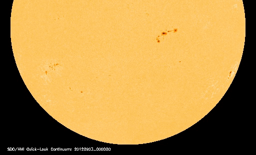
SUNSPOT AR1564:
The next strong flare could be just around the corner. Sunspot AR1564 is growing rapidly and has developed a ‘beta-gamma’ magnetic field that harbors energy for M-class flares. NASA’s Solar Dynamics Observatory took this picture of the active region during the early hours of Sept. 4th:
NOAA forecasters estimate a 40% chance of M-flares during the next 24 hours. Any eruptions will likely be Earth-directed as the active region is turning toward our planet.

Solar wind
speed: 422.7 km/sec
density: 15.2 protons/cm3
explanation | more data
Updated: Today at 0735 UT
X-ray Solar Flares
6-hr max: C2 0507 UT Sep04
24-hr: C2 0507 UT Sep04
explanation | more data
Updated: Today at: 0700 UT
![]()
Daily Sun: 04 Sep 12
![]()
Sunspot 1564 is suddenly growing. It has a ‘beta-gamma’ magnetic field that harbors energy for M-class solar flares. Credit: SDO/HMI
![]()
Sunspot number: 156
What is the sunspot number?
Updated 04 Sep 2012
Spotless Days
Current Stretch: 0 days
2012 total: 0 days (0%)
2011 total: 2 days (<1%)
2010 total: 51 days (14%)
2009 total: 260 days (71%)
Since 2004: 821 days
Typical Solar Min: 486 days
Update 04 Sep 2012
The Radio Sun
10.7 cm flux: 142 sfu
explanation | more data
Updated 04 Sep 2012
![]()
Current Auroral Oval:

Switch to: Europe, USA, New Zealand, Antarctica
Credit: NOAA/POES
![]()
Planetary K-index
Now: Kp= 3 quiet
24-hr max: Kp= 6 storm
explanation | more data
Interplanetary Mag. Field
Btotal: 2.8 nT
Bz: 1.5 nT north
explanation | more data
Updated: Today at 0737 UT
![]()
Coronal Holes: 04 Sep 12
![]()
There are no large coronal holes on the Earthside of the sun. Credit: SDO/AIA.
************************************************************************************************************
Space
SUBSIDING STORM:
A geomagnetic storm that began on Sept. 3rd when a coronal mass ejection (CME) hit Earth’s magnetic field is fitfully subsiding. The impact at 1200 UT (5 am PDT) induced significant ground currents in the soil of northern Scandinavia and sparked bright auroras around the Arctic Circle. Ole C. Salomonsen photographed the display over Naimakka, Finland, on Sept. 4th:

“There I was standing all alone deep in the Finish forest, just in awe of this display of light above my head,” says Salomonsen. “This is just one of many images of spectacular auroras I shot on this wonderful night.”
Earth approaching objects (objects that are known in the next 30 days) |
|||||||||
| Object Name | Apporach Date | Left | AU Distance | LD Distance | Estimated Diameter* | Relative Velocity | |||
| (2012 PX) | 04th September 2012 | 0 day(s) | 0.0452 | 17.6 | 61 m – 140 m | 9.94 km/s | 35784 km/h | ||
| (2012 EH5) | 05th September 2012 | 1 day(s) | 0.1613 | 62.8 | 38 m – 84 m | 9.75 km/s | 35100 km/h | ||
| (2011 EO11) | 05th September 2012 | 1 day(s) | 0.1034 | 40.2 | 9.0 m – 20 m | 8.81 km/s | 31716 km/h | ||
| (2007 PS25) | 06th September 2012 | 2 day(s) | 0.0497 | 19.3 | 23 m – 52 m | 8.50 km/s | 30600 km/h | ||
| 329520 (2002 SV) | 08th September 2012 | 4 day(s) | 0.1076 | 41.9 | 300 m – 670 m | 9.17 km/s | 33012 km/h | ||
| (2011 ES4) | 10th September 2012 | 6 day(s) | 0.1792 | 69.8 | 20 m – 44 m | 12.96 km/s | 46656 km/h | ||
| (2008 CO) | 11th September 2012 | 7 day(s) | 0.1847 | 71.9 | 74 m – 160 m | 4.10 km/s | 14760 km/h | ||
| (2007 PB8) | 14th September 2012 | 10 day(s) | 0.1682 | 65.5 | 150 m – 340 m | 14.51 km/s | 52236 km/h | ||
| 226514 (2003 UX34) | 14th September 2012 | 10 day(s) | 0.1882 | 73.2 | 260 m – 590 m | 25.74 km/s | 92664 km/h | ||
| (1998 QC1) | 14th September 2012 | 10 day(s) | 0.1642 | 63.9 | 310 m – 700 m | 17.11 km/s | 61596 km/h | ||
| (2002 EM6) | 15th September 2012 | 11 day(s) | 0.1833 | 71.3 | 270 m – 590 m | 18.56 km/s | 66816 km/h | ||
| (2002 RP137) | 16th September 2012 | 12 day(s) | 0.1624 | 63.2 | 67 m – 150 m | 7.31 km/s | 26316 km/h | ||
| (2009 RX4) | 16th September 2012 | 12 day(s) | 0.1701 | 66.2 | 15 m – 35 m | 8.35 km/s | 30060 km/h | ||
| (2005 UC) | 17th September 2012 | 13 day(s) | 0.1992 | 77.5 | 280 m – 640 m | 7.55 km/s | 27180 km/h | ||
| (2012 FC71) | 18th September 2012 | 14 day(s) | 0.1074 | 41.8 | 24 m – 53 m | 3.51 km/s | 12636 km/h | ||
| (1998 FF14) | 19th September 2012 | 15 day(s) | 0.0928 | 36.1 | 210 m – 480 m | 21.40 km/s | 77040 km/h | ||
| 331990 (2005 FD) | 19th September 2012 | 15 day(s) | 0.1914 | 74.5 | 320 m – 710 m | 15.92 km/s | 57312 km/h | ||
| (2009 SH2) | 24th September 2012 | 20 day(s) | 0.1462 | 56.9 | 28 m – 62 m | 7.52 km/s | 27072 km/h | ||
| 333578 (2006 KM103) | 25th September 2012 | 21 day(s) | 0.0626 | 24.4 | 250 m – 560 m | 8.54 km/s | 30744 km/h | ||
| (2002 EZ2) | 26th September 2012 | 22 day(s) | 0.1922 | 74.8 | 270 m – 610 m | 6.76 km/s | 24336 km/h | ||
| (2009 SB170) | 29th September 2012 | 25 day(s) | 0.1789 | 69.6 | 200 m – 440 m | 32.39 km/s | 116604 km/h | ||
| (2011 OJ45) | 29th September 2012 | 25 day(s) | 0.1339 | 52.1 | 18 m – 39 m | 4.24 km/s | 15264 km/h | ||
| (2012 JS11) | 30th September 2012 | 26 day(s) | 0.0712 | 27.7 | 270 m – 600 m | 12.60 km/s | 45360 km/h | ||
|
|||||||||
*************************************************************************************************************
Biological Hazards / Wildlife
| Today | Biological Hazard | India | State of Tamil Nadu, Coimbatore [Government Polytechnic College for Women] |
Biological Hazard in India on Tuesday, 04 September, 2012 at 02:59 (02:59 AM) UTC.
| Description | |
| Forty-six students of Government Polytechnic College for Women at Sidhapudur in the heart of Coimbatore city became ill on Monday following suspected food poisoning. They were admitted at two hospitals in the vicinity after they complained of severe vomiting and stomach pain. The students developed discomfort after having dinner at the college hostel cafeteria on Sunday. While 11 of them were admitted at Ramakrishna hospital on Sunday night itself, 35 students were rushed to the Coimbatore Medical College and Hospital (CMCH) at around 8 am on Monday. Seven of them are being kept in the Intensive Care unit at CMCH and Ramakrishna hospital. The doctors attending to the students said that most of them were admitted with complaints of vomiting, diarrhea and stomach pain. They were put on drips and medication. P Sivaprakasam, resident medical officer of CMCH said initial examinations had revealed that the students were suffering from food poisoning. He also said that they had consumed contaminated water. “They are recovering well and will be discharged in a couple of days,” he added.
A Kalpana, a third year student recovering at CMCH said that on Sunday night they were served tomato rice for dinner. For the past week the drinking water supply was not proper. Some students may have consumed contaminated water or it may have been used for cooking,” said another student on conditions of anonymity. “Just a few months ago the students had oragnised a public protest demanding good quality food. The case of food poisoning highlights the grim situation prevailing at the hostel,” she added. The doctors say that students fell ill because of consuming contaminated water. What has happened is unfortunate. We will look into the issue and ensure this does not happen again. Corrective measures will be put in place,” said B Padmini, principal of the college. There are 300 students residing at the hostel. Most hostel students are sports players, she said. “Students may have consumed pipe water instead of the boiled water made available to them. This is despite several reminders to drink only boiled water,” the principal added. Regarding the allegation of inadequate drinking water supply in the past one week, Padmini said that on certain days there was a disruption in supply. |
|
| Biohazard name: | Mass. Food Poisoning |
| Biohazard level: | 0/4 — |
| Biohazard desc.: | This does not included biological hazard category. |
| Symptoms: | |
| Status: | |
| 03.09.2012 | Biological Hazard | Kyrgyzstan | Chuy Oblast, [About 20 kilometers of the Kant Air Base] |
Biological Hazard in Kyrgyzstan on Monday, 03 September, 2012 at 18:47 (06:47 PM) UTC.
| Description | |
| Russia’s military officials say that efforts to prevent an anthrax epidemic have been increased at a Russian air base in Kyrgyzstan because of an outbreak of anthrax nearby. Officials from Russia’s Central Military District say one of the outbreaks is within 20 kilometers of the Kant Air Base in Kyrgyzstan’s northern region of Chui. He says all military buildings on the base — including apartments for officers and their families — have been disinfected and safety checks on food supplies have been increased. The move was undertaken after Kyrgyz health officials announced last week that several cases of anthrax had been confirmed in Chui and in the southern regions of Jalal-abad and Batken. | |
| Biohazard name: | Anthrax |
| Biohazard level: | 0/4 — |
| Biohazard desc.: | This does not included biological hazard category. |
| Symptoms: | |
| Status: | |
| 04.09.2012 | Biological Hazard | United Kingdom | Scotland, Saint-Andrews |
Biological Hazard in United Kingdom on Sunday, 02 September, 2012 at 19:19 (07:19 PM) UTC.
| Updated: | Monday, 03 September, 2012 at 07:41 UTC |
| Description | |
| A wildlife rescue organization says 13 whales have died following a mass stranding off the Scottish coast. British Divers and Marine Life Rescue said Sunday that the mammals were among a group of 26 pilot whales stranded at Pittenweem, in eastern Scotland. Coast guards, volunteer medics, fire crews and police are all also involved in efforts to rescue the 13 still living. But rescue coordinator Gareth Norman said that it was likely more of the whales would die. A further 24 pilot whales from the same pod are currently in shallow water three miles along the coast at Cellardyke. | |
Whales beach themselves in UK, US

Scientists and conservationists are once again puzzled over the behaviour of whales – with two different pods of pilot whales beaching themselves this weekend on either side of the Atlantic.
A pod of 26 pilot whales stranded themselves off the coast of Fife in Scotland.
Crowds of on-lookers gathered to watch the massive rescue and relief operation.
13 of the 26 whales did not make it.
And in a strange coincidence… another pod of whales beached themselves along the coast of south-central Florida in the U.S.
This time, 22 pilot whales stranded themselves near Fort Pierce.
Only five whales survived.
VERO BEACH, Fla., Sept. 2 (UPI) — Wildlife experts suspect an ailing alpha whale caused a pod of short-fin pilot whales to beach themselves in Florida this weekend.
Seventeen of the 22 mammals died in the surf at Avalon Beach State Park in St. Lucie County and five juveniles were taken to a rescue facility at nearby Florida Atlantic University, but were not expected to survive.
Blair Mase, who specializes in the study of whale stranding for the U.S. government, told TCPalm.com the tragedy was probably linked to the pod leader.
“This species has a tight social structure,” said Mase, a regional coordinator for the National Oceanographic and Atmospheric Administration. “Typically, they stay together as a group. So if one animal is sick, they all come ashore.”
Hundreds of people on the area either watched the stranding unfold. Many tried to help out by throwing wet towels on the whales to protect them from the sun, TCPalm.com said.
Mase it would not have done much good to push the whales off the sand. “If you push them into the water, they’ll just keep coming back and stranding themselves again,” she said.
*************************************************************************************************************
[In accordance with Title 17 U.S.C. Section 107, this material is distributed without profit, for research and/or educational purposes. This constitutes ‘FAIR USE’ of any such copyrighted material.]


